The Wild Fish Conservancy and other fishing groups have sent a request to the governors and fish & wildlife department directors and commissioners of Washington, Oregon, and California, and NOAA Fisheries, “urging the states to immediately implement emergency measures that would close all river reaches to all fishing, both recreational and commercial, that exceed 18°C (64.4°F), until water temperatures and flows return to more normal conditions”.1 The petition notes that the drought (they referred to as “weather abnormalities”) have caused low flows and high water temperatures in rivers, streams, and lakes.
“A report released today by the Conservancy indicates that current water temperatures in almost all salmon and trout bearing rivers and streams analyzed in Washington, Oregon, and California have exceeded thresholds which result in biological stress, indirect mortality, and reduced spawning success. Furthermore, lethal conditions were detected in 39 of 54 of the rivers and streams.”
CDFW, in its CDFW News Blog, recommended on June 22 that anglers not fish whenever water temperatures exceed 70°F. 2
While the threshold temperature for the decision not to fish is somewhat species dependent, anglers should give careful thought to where they fish in hot weather, low water conditions.
Northern California Lakes and Reservoirs
Popular trout fishing locations in northern California include Shasta, Oroville, Almanor, Davis, Eagle, Siskiyou, Bullards Bar, and Folsom reservoirs, as well as many smaller foothill and Sierra lakes and reservoirs. Nearly all of these waters have surface temperatures in the mid-seventies in summer. Although these are not wild trout fisheries and are sustained primarily by stocking, many are quality fisheries that have carryover trout prized by many fishermen. Catch-and-release should be discouraged in these waters in summer, as many of the trout (and salmon) caught would likely die if released. Some guides and private waters no longer offer fishing in these waters because of the warm water. Harvested fish should be immediately put on ice and not on stringers.
Northern California River and Streams
Northern California is rich in cold water stream fisheries sustained by large springs (e.g., Hat Creek, Fall River, upper Battle Creek, upper McCloud, and upper North Fork Feather), and by others sustained by cold-water reservoir releases (e.g., upper Lower Trinity River, upper Lower Sacramento River below Shasta, and lower Yuba River). These waters can sustain fisheries through the summer even in most drought years.
However there are some streams that should be closed, partially closed, or considered for closure on a case-by-case basis. These include the Klamath, lower Trinity, lower sections of the upper Sacramento and lower McCloud, the Pit above Shasta, and the lower Truckee rivers.
Some selected water temperature charts are included below. They are available on CDEC, DWR’s streamflow and reservoir website.3 Check the web before you head out.
Upper Sacramento River upstream of Shasta Reservoir

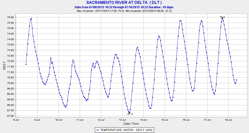
Lower Sacramento River below Redding.
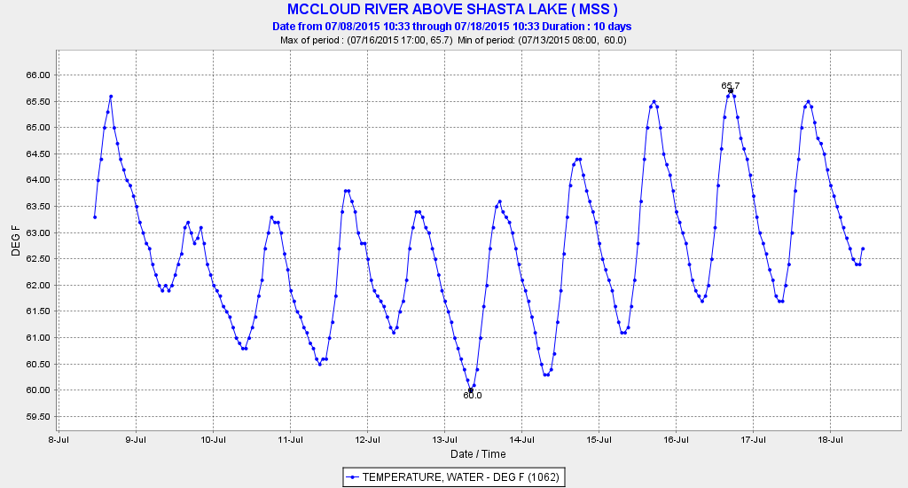
McCloud River above Shasta Reservoir

Lower Truckee River near Nevada border.
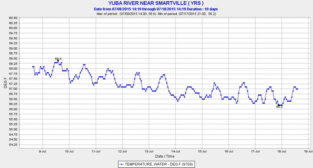
Lower Yuba River below Englebright Dam
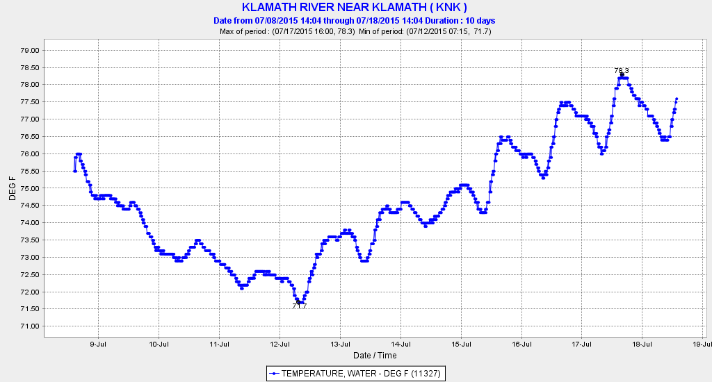
Lower Klamath River.
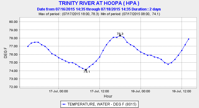
Lower Trinity River.
- http://wildfishconservancy.org/about/press-room/press-releases/extreme-water-temperatures-low-flows-in-pacific-northwest-rivers-creating-lethal-conditions-for-salmon ↩
- https://cdfgnews.wordpress.com/ (Search June 22, 2015) ↩
- http://cdec.water.ca.gov/river/rivcond.html It takes some trial and error to find the temperature plots, and not all stations have them. Generally, if you click on the title in blue below each graph it directs you to a list of data available for the station. The blue headers for each category of data are links, which opens up further graphing functions. ↩