This winter, a host of stakeholders are examining how Chico-area waterways and the Chinook salmon and steelhead trout that live in them are faring, after the intense burning of the July-September 2024 Park Fire. Two of the most interesting sets of observations will come from Deer Creek and Mill Creek, which are tributaries of the Sacramento River. These undammed creeks have long been known for their ability to support unique populations of Central Valley spring-run Chinook salmon and of steelhead trout. Learning how severely the fire impacted the fishes’ populations will determine what actions state, federal, Tribal, local, nonprofit, and resident partners take next.
The Park Fire impacted five separate watersheds: Big Chico Creek, Deer Creek, Mill Creek, Antelope Creek, and the South Fork of Battle Creek.
“The Deer Creek and Mill Creek spring-run populations of Chinook salmon are independent, self-sustaining wild runs. They’re genetically distinct from other Central Valley Chinook salmon populations. The Park Fire burned portions of upper Mill Creek in an extremely hot and catastrophic way,” said Matt Johnson, environmental scientist for California Department of Fish and Wildlife (CDFW).
Due to this set of circumstances, the recovery of Mill Creek in particular is likely to teach CDFW and other partners how fish respond to a heavy sediment load, irregular percentages of fire retardant, and reduced groundcover.
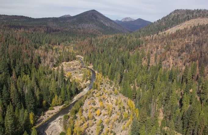
The watershed along Upper Mill Creek, taken via helicopter in October 2024, before the Park Fire. Image: Patrick Jarrett and California Department of Fish and Wildlife
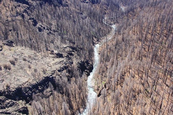
Impacts of the Park Fire along Mill Creek, photo taken from a helicopter in May 2025. Image: Patrick Jarrett and California Department of Fish and Wildlife
Background on the two waterways
Deer Creek and Mill Creek are the main waterways in foothills at the very southern end of the Shasta Cascade mountain range.
Mill Creek begins on the southern slopes of Lassen Peak and flows southwest for approximately 60 miles. Most of the creek flows through a deep canyon, except for a stretch at about the 5000-foot elevation where it flows through several meadows. Downstream of the canyon, Mill Creek flows for 8 miles through agricultural land. It joins the Sacramento River at Los Molinos. Mill Creek is generally located roughly 10 miles north and west of Deer Creek.
Deer Creek begins on Butt Mountain and flows southwest for about 60 miles. Deer Creek makes its way through meadows and dense forests. State Highway 32 runs along Deer Creek for many miles. Along Highway 32 and downstream of where creek and highway are close, Deer Creek flows through a rock canyon. Like Mill Creek, Deer Creek flows through agricultural land in its lower reaches before it joins the Sacramento River near the town of Vina.
Effects of the Park Fire
The Park Fire began in Bidwell Park in Chico on July 24, 2024 and spread north and northeast. It burned approximately 429,603 acres before it was fully contained in late September 2024.
“The fire-affected area is a mosaic of recovery. It contains spots where there were different fire intensities. At one point, there was an accidental drop of fire retardant in South Fork Battle Creek. I’m sure this washed into waterways throughout the watershed,” said Johnson.
Johnson said CDFW has not played a large part in the recovery of Deer and Mill Creeks, so far.
“We do not have the staff and funding to adequately assess and monitor watershed-scale impacts of this fire. We are doing what we can in an important watershed in our backyard,” said Johnson.
This fall, CDFW performed sediment monitoring in Deer and Mill Creeks before the rainy season.
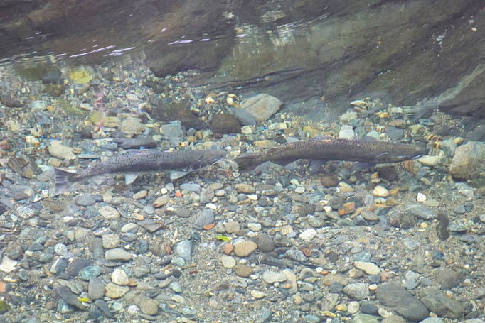
Spring-run Chinook salmon in Mill Creek in 2013. Image: Patrick Jarrett and California Department of Fish and Wildlife
Spring-run Chinook salmon in Deer Creek in 2013. This fish was found in an irrigation ditch and returned to Deer Creek. Image: Patrick Jarrett and California Department of Fish and Wildlife
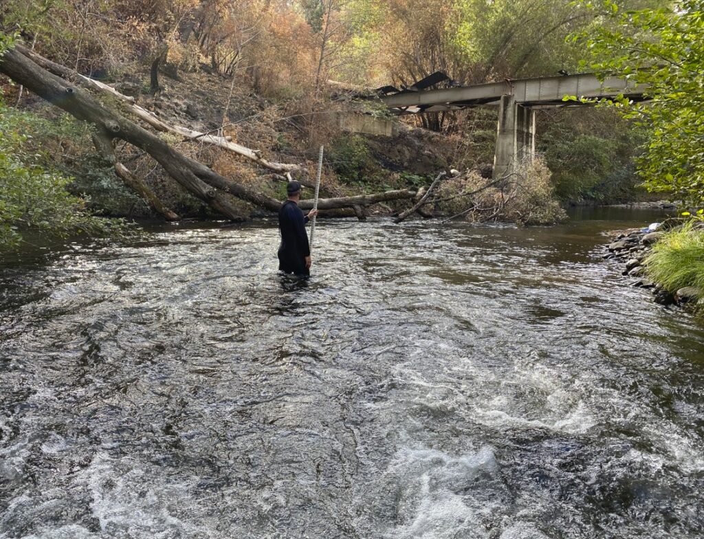
Mike Memeo, Senior Environmental Specialist for California Department of Fish and Wildlife, takes samples in Mill Creek for a sediment survey in 2024, after the Park Fire. Image: Patrick Jarrett and California Department of Fish and Wildlife
“In 2024, we did pre-fire sediment-load observation in a few key locations within the habitat for spring-run Chinook salmon. In 2025, we made the same types of observations in the same spots, to see the difference. We’re currently analyzing that data,” said Johnson.
The negative effects of the fire included higher sediment loads in water, ash runoff in water, and higher pH of water. All of these factors lead to poor water quality overall.
Fire retardants compromise water quality because fire retardants are generally acidic, with a pH as low as 5.0. When they run off into creeks, the pH of those waterways becomes lower. Wildfire ash, which also entered the creeks, has a pH of between 9 and 13, meaning it is more alkaline.
The fire retardant and ash are not evenly distributed and do not “cancel each other out” in a way that makes the environment hospitable for wildlife. When and where the low pH fire retardant washes into streams, the neutral water becomes more acidic. This makes it easier for metals like lead and arsenic to dissolve in the water. The high pH ash is corrosive and toxic. These factors contribute to an environment that is doubly dangerous for fish.
One area that has had a head start on recovery processes is Big Chico Creek. Residents and nonprofits in this area have the help of Butte Creek Resource Conservation District (Butte Creek RCD). With funding from Chico State University, Sierra Nevada Brewery, and Proposition 68, a state measure passed in 2018, Butte Creek RCD built a number of rock-log leaky weirs to assist in replacing ground cover, trap loose sediment, and stopping erosion.
CDFW is watching how those structures perform.
“We’re going to try to duplicate that effort. Our recovery plan will target some meadows that were impacted by the Park Fire. It’s all about preserving cold summer flows,” said Johnson.
CDFW is also looking to engage in more proactive forest thinning and prescribed fires, to take better care of the existing habitat that did not burn. The goal is to ensure that the areas around the creeks do not burn catastrophically again.
The effects of federal changes
The National Marine Fisheries Service (NMFS) usually coordinates with the state of California on a game plan to assist native fish species after large-scale incidents like the Park Fire. But NMFS’s presence in this area has been “non-existent” since January 2025 due to cuts by the Department of Government Efficiency (DOGE).
“There’s been no boots on the ground [from the federal government]. In addition, the latest shutdown of the federal government [(Oct. 1 to Nov. 12, 2025] further impacted NMFS’s engagement regarding spring-run Central Valley Chinook and Central Valley steelhead,” said Johnson.
The U.S. Department of Agriculture (USDA) also has a program to assess and treat severely burned areas. This is called Burned Area Emergency Response (BAER). But even when USDA implements this program, it typically only treats a portion of the burned area. In the case of Deer and Mill creeks, one focus area might be the ½ to ⅔ of the severely burned area on upper Mill Creek.
“There are issues with deteriorating roads that need to be fixed, culverts that need to be replaced, and certain stream crossings in this area. Many of the spots that need work are on federal land,” said Johnson.
Pre-fire concerns and hopeful signs
Prior to the Park Fire, Central Valley spring-run Chinook salmon populations in Deer Creek and Mill Creek were already on the brink of collapse. CDFW had been engaging in a year-round count of fish from both waterways, using video monitoring stations on the valley floor.
In the summertime, CDFW employees have snorkeled 25 miles of Deer Creek and engaged in walking surveys of 35 miles of Mill Creek, examining redds. The population estimate for Deer Creek in 2023 was 23 spring-run Chinook salmon. The population estimate for Mill Creek that year was 34 spring-run Chinook salmon. In 2024, the numbers varied slightly, but were still very depressed: 33 spring-run Chinook salmon in Deer Creek and 18 spring-run Chinook salmon in Mill Creek.
“This was probably not enough fish to sustain populations over time. Yet this year, we saw a boost in numbers, around 300 Chinook salmon in Deer Creek and 200 Chinook salmon in Mill Creek,” said Johnson.
The changes are due to a wet water year in 2023 and resulting improved migration survival of juvenile salmon throughout the Central Valley. Salmon that returned to Mill Creek and Deer Creek as adults in 2025 are largely fish that were juveniles in 2023. The complete closure of commercial fishing for salmon in California and the almost complete closure of recreational fishing for salmon in 2025 likely also contributed to improved numbers of adult spawners in 2025.
The higher population numbers for 2025 do not indicate that conditions in these creeks post-Park Fire are optimal for Chinook salmon and other native fish species. The higher numbers of fish are linked to the Chinook salmon returning home as adults from the Pacific Ocean. It remains to be seen how many eggs from salmon that spawn in 2025 will survive.
“We’re now in a wait-and-see moment. We’re hoping the eggs survive and the fish make it to juvenile and young adult stages, despite warmer temperatures, potential mass wasting of hillsides, and impacts on the water and sediment that negatively affect the redds,” said Johnson.
Community engagement and interest
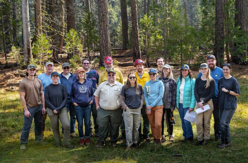
Community members are sharing their voices about how to address issues in the two creeks. State and federal agencies are likely to take local recommendations into consideration. The entities involved include community residents, Tribes, state and federal agencies, Resource Conservation Districts, corporations and nonprofits. All of these entities are engaging in part because of the work of the Sierra Institute, a nonprofit based in Taylorsville, California. The Sierra Institute supports landscape-scale restoration and local workforce development. It emphasizes community involvement and participation to improve conditions in natural environments.
Vincent Vitale, Rural Community Outreach Coordinator for the Sierra Institute, said the work relating to Deer and Mill Creeks is part of the West Lassen Headwaters Project. The South Lassen Watersheds Group (SLWG), which the Sierra Institute facilitates, is under this Project. The SLWG focuses on a million-acre footprint within the Project area. The SLWG has 25 different member entities, which include state and federal agencies, corporations, environmental non-profits, Tribes, and individual community members.
“The Sierra Institute has established a Memorandum of Understanding (MOU). It acts as a collaborative mechanism and organizational tool to bring diverse stakeholders and perspectives together. We are determining what it takes to steward these lands,” said Vitale.
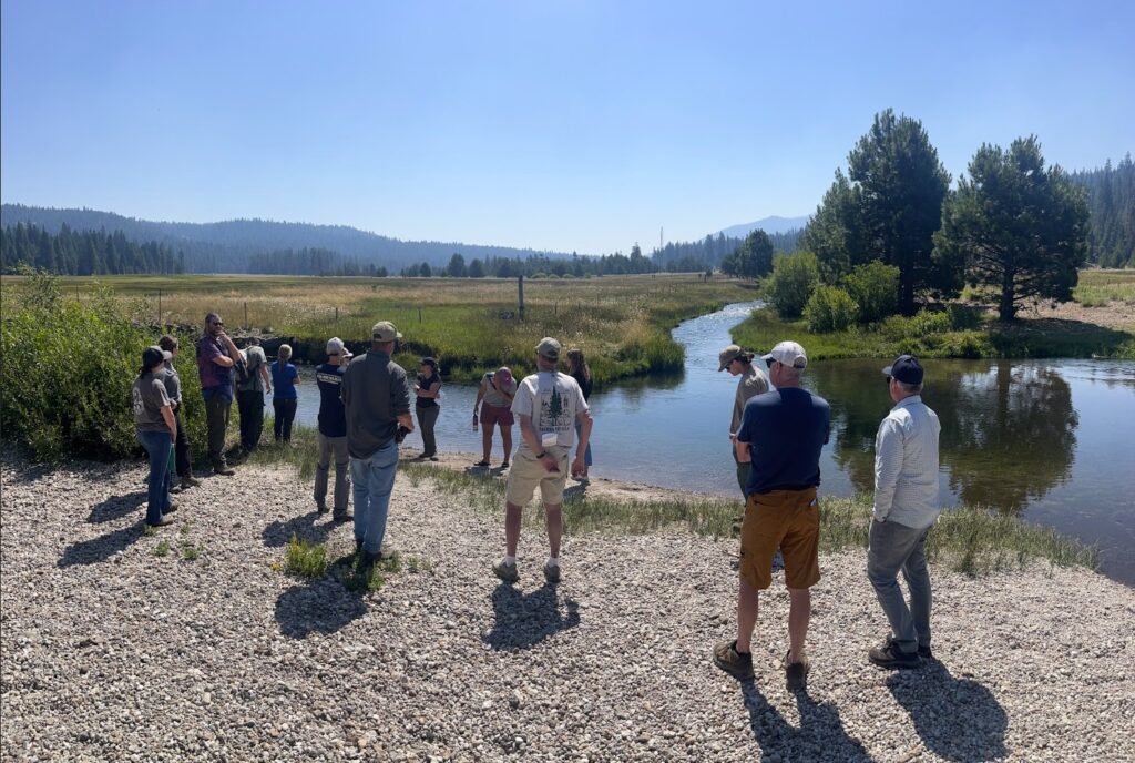
Members of the Hydrology and Aquatic Habitat Subcommittee, part of the South Lassen Watersheds Group, which is organized by the Sierra Institute, listen to speakers discuss meadow restoration to support watershed health in July 2025. Image: Sierra Institute
Members of the Hydrology and Aquatic Habitat Subcommittee of the South Lassen Watersheds Group on a field tour in southwest Lassen National Forest in October 2025. Image: Sierra Institute
The SLWG started in 2017, and meets once or twice during the winter months online. During the fall, spring, and summer, SLWG members meet two to three times per season, in the field.
“We visit spots of interest to see what’s going on throughout the region. That way we can observe the concerns and potential for land management throughout the upper watersheds,” said Vitale.
The U.S. Forest Service is a significant partner in the work, because much of the land is federal land.
The Sierra Institute, along with affiliated groups such as the SLWG, serves as a planning partner for both state and federal agencies.
“This year, however, has been challenging due to federal budget cuts and the October–November [2025 federal government] shutdown,” said Vitale.
The DOGE cuts and the shutdown led to reductions in federal staff, questions about job permanency for remaining staff, and long periods of uncertainty regarding staff and funding. It is unclear whether there will be stop orders on grants. It is also unclear whether all federal regional offices will continue to remain open.
“These changes could trigger a cascade of ripple effects, significantly impacting our agency partners. The Sierra Institute and the Lassen National Forest have completed the Environmental Assessment for the West Lassen Headwaters Project, a collaborative, landscape-scale effort covering 101,000 acres. With the decision [for this environmental assessment] signed on October 15th, a large swath of land is now ready for implementation,” said Vitale.
One plus for the Sierra Institute and local residents is that the U.S. Forest Service did not stop communication with SLWG during the shutdown.
“When the shutdown started, the U.S. Forest Service was already well into planning what actions to take to remediate the watersheds. The staff at Lassen National Forest made this a priority project. They directed the resources that were still in existence to continuing talks with SLWG,” said Vitale.
The Sierra Institute has learned the U.S. Forest Service is interested in reducing hazardous fuels around Mill Creek. It is also interested in engaging in clean-up around river banks and building and placing structures in creeks to mitigate future harmful effects, like high sediment load.
“We’re having at least one meeting just to think about the Deer Creek corridor. We want to address sediment capture and spawning habitat. The participants of the SLWG and the Sierra Institute are looking to pursue funding and submit grant applications to support implementation of such work,” said Vitale.
There may also be funding available from Proposition 4, a 2024 state measure that authorized $10 billion in bonds for safe drinking water, wildfire prevention, and protecting communities and natural lands from climate risks.
“The challenge is that there are a lot of entities competing for this pot of money,” said Vitale.
The area that will be the hardest to treat is the steep, rugged terrain around Deer Creek. It is hard to get vehicles into many locations, and different tools may be needed to alter the natural environment.
Howard Brown, a member of the Hydrology and Aquatic Habitat Subcommittee of the SLWG, has contributed a great deal of insight and experience to discussions.
“I worked for the U.S. Forest Service on the Lassen National Forest from 1994 to 2001. I am also a retired Branch Chief and Policy Advisor with the National Oceanic and Atmospheric Administration’s National Marine Fisheries Service. I played a significant role developing the 2014 Recovery Plan for The Evolutionarily Significant Units of Sacramento River Winter-run Chinook Salmon and Central Valley Spring-run Chinook Salmon and the Distinct Population Segment (DPS) of California Central Valley Steelhead,” said Brown.
Brown said that across their range in the Sacramento River Basin, spring-run Chinook salmon probably suffered more than steelhead from the Park Fire. This is because steelhead trout have other footholds and strongholds in watersheds throughout the Central Valley.
“Mill and Deer creeks represent some of the most significant streams for remaining [spring-run] populations,” said Brown.
He added that below 2,000 feet, the fire landscape is more resilient and remains an important part of ecosystem processes.
“But in the upper parts of the watershed, fire has essentially been removed from the ecosystem for 125 years. The risk and effects to landscapes and ecosystems from high severity wildfire is more significant,” said Brown.
The University of California, San Diego has worked with Pacific Gas & Electric Company and other entities to point a broad array of webcams at different parts of Lassen National Forest to help monitor wildfires.
“This network of cameras allows us to watch fires from different angles, like we did during the Park Fire. We saw the fire barreling down through the upper parts of Mill Creek and through the Big Bend Reach. This is one of the most important spawning reaches for Central Valley spring-run Chinook salmon. Sadly, we were able to observe the old growth forest get absolutely incinerated during the fire. We knew this would have devastating consequences for salmon habitat,” said Brown.
When SLWG members see a fire happening in real time, they can think about post-fire effects on creeks, roads, and forests, to consider how to address concerns later.
“We need to stabilize sediment delivery to streams through road treatments, sediment capturing structures and other erosion control actions. We also need to implement actions to improve salmon habitat and salmon survival through gravel augmentation. Some of that work will be done by private timber companies. Other projects should be completed by state and federal agencies. It’s going to take collaborative partnerships to effectively coordinate these actions,” said Brown.
Brown added that introducing prescribed burns onto the landscape is an important tool for making forests more fire-resilient. Such actions may help prevent catastrophic fires with negative effects on native fish species later.
A perspective from a local flyfisher
PJ Bock is a member of Chico Area Flyfishers, a local flyfishers’ club that was founded in 1972. He is also the owner of Bock Fly Fishing, a fish guide company that he established in 2020.
Bock has been fishing in Deer Creek for years, even before establishing his business. He concentrates on a 10-mile stretch along Highway 32 from the first bridge over Deer Creek, called “red bridge” or “orange bridge,” to a spot along either Highway 36 or Highway 89. This is a commonly fished area of the creek. There is a secret access point that locals often use to fish.
“This year, I noticed fishing steelhead trout wasn’t as good as I expected it to be. I don’t know if the Park Fire is 100 percent the reason for that or there are cyclical factors involved,” said Bock.
The fire heavily impacted Bock’s business.
“I often took clients to Deer Creek. Right when the fire started in July is the time I usually took clients to go up there. I couldn’t do that during the fire or any time afterwards. The area is recovering now. I will be able to take clients up there after the winter,” said Bock.
From Bock’s perspective, Big Chico Creek was more affected by the Park Fire than Deer Creek.
“I saw issues with sediment runoff. Usually fishing for smallmouth bass is good. This year, that was just abysmal,” said Bock.
It can be much harder to fish on Mill Creek, because the area is more rugged.
“Along that creek, it burned up to the headwaters. It closed down a stretch of Highway 36 along the creek,” said Bock.
Fortunately for Bock, fishing guides always have back-up spots.
“I book small stream clinics in the summer. Those will help if there are concerns in Deer Creek and other large creeks,” said Bock.
Bock said he is excited about restoration efforts in Deer and Mill Creeks. This year, he has been sharing more of his observations about fishing in the two creeks with Chico Area Flyfishers members.
“I’ve even taken a few members up to Deer Creek. This is a new thing, because a lot of members have been fishing out of the area, even in Mexico. What I’ve done to adjust after the fire, the work that the Butte Creek Resource Conservation District is doing, and news coverage of the Park Fire, is all encouraging local fishermen to have more of an understanding of what needs to happen for recovery, and how their input could make a difference,” said Bock.