Fremont Weir Fish Passage Update

The Fremont Weir fish passage improvements at the upper end of the Yolo Bypass (see previous posts for details1) are mandated in the National Marine Fisheries Service’s Central Valley Project and State Water Project joint biological opinion (2009 OCAP BO). The OCAP BO that allows limited take of endangered salmon, steelhead, and sturgeon for the wide array of water projects’ features (i.e. dams and water diversions), provided various improvements are made.

So far, as of the beginning of 2016 there have been no improvements or fixes at Fremont Weir, just more planning and discussion. Meanwhile, CDFW rescued hundreds of stranded salmon in the upper Bypass this fall. There has been no rescue of sturgeon since the Fremont Weir and Tisdale Weir rescue efforts in April 2011, when 24 endangered Green Sturgeon were rescued and radio tagged (21 eventually returned to the Pacific Ocean after migrating to spawning grounds in the upper Sacramento River2). Because of the drought, there have been no river flood flows over Fremont Weir into the Bypass since the April 2011 event. (Overflow of the Tisdale Weir into the Sutter Bypass did occur in Dec 2012 and Jan 2013.). However, salmon and sturgeon continue to be attracted to the Bypass by flows from local sources and to become stranded at the upper end of the Bypass.

“Fixes” under consideration for Fremont Weir include changes that would allow the Sacramento River to flood parts of the bypass at lower flows. The amount of water that might be diverted to the Yolo Bypass from the Sacramento River through prospective changes to the weir ranges from several hundred cfs to 6000 cfs. The larger end of the range of flows would be designed to provide for Bypass rearing of young salmon that would pass along with the water from the river to the Bypass. There is little doubt that young salmon do well in the over 40 miles of floodway habitats of the Bypass. The Delta also benefits from flow through the Bypass because of enhanced biological productivity.

It will take years to plan and implement such large sized enhancements in the Bypass. But an immediate solution to the adult salmon and sturgeon passage problem at Fremont Weir is not that complicated or contingent on other actions. OCAP BO Action 1.7– a Fremont Weir Ladder Project (reproduced below, with a deadline that is 5 years past) – should be implemented now


OCAP 

Action I.7. Reduce Migratory Delays and Loss of Salmon, Steelhead, and Sturgeon at Fremont Weir and Other Structures in the Yolo Bypass

Objective: Reduce migratory delays and loss of adult and juvenile winter-run, spring-run, CV steelhead and Southern DPS of green sturgeon at Fremont Weir and other structures in the Yolo Bypass.

Description of Action: By December 31, 2011, as part of the plan described in Action I.6.1, Reclamation and/or DWR shall submit a plan to NMFS to provide for high quality, reliable migratory passage for Sacramento Basin adult and juvenile anadromous fishes through the Yolo Bypass. By June 30, 2012, Reclamation and/or DWR shall obtain NMFS concurrence and, to the maximum extent of their authorities, and in cooperation with other agencies and funding sources, begin implementation of the plan, including any physical modifications. By September 30, 2009, Reclamation shall request in writing that the Corps take necessary steps to alter Fremont Weir and/or any other facilities or operations requirements of the Sacramento River Flood Control Project or Yolo Bypass facility in order to provide fish passage and shall offer to enter into a Memorandum of Understanding, interagency agreement, or other similar mechanism, to provide technical assistance and funding for the necessary work. By June 30, 2010, Reclamation shall provide a written report to NMFS on the status of its efforts to complete this action, in cooperation with the Corps, including milestones and timelines to complete passage improvements.

Rationale: The Yolo Bypass and Fremont Weir has been a documented source of migratory delay to, and loss of, adult winter-run, spring-run, CV steelhead and Southern DPS of green sturgeon. The existing fish passage structure is inadequate to allow normal passage at most operational levels of the Sacramento River. The project agencies must work with the Corps, which owns and operates Fremont Weir, to achieve improvements for fish. Other structures within the Yolo Bypass, such as the toe drain, Lisbon Weir, and irrigation dams in the northern end of the Tule Canal, also can impede migration of adult anadromous fish.

Additionally, stranding of juvenile salmonids and sturgeon has been reported in the Yolo Bypass in scoured areas behind the weir and in other areas. This action offsets unavoidable project effects on adult migration and minimizes the direct losses from flood management activities associated with operations.
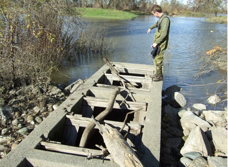


Photo of Fremont Weir Fish Ladder

Fremont Weir Fish Ladder (Looking North towards flooded Sacramento River)

Fremont Weir Ladder Project

Fremont Weir Fish Ladder Replacement. “The existing Fremont Weir Denil fish ladder will be removed and replaced with new salmonid passage facilities designed to allow for the effective passage of adult salmonids and sturgeon from the Yolo Bypass past the Fremont Weir and into the Sacramento River when the river overtops the weir. Specific design criteria of the ladder have not yet been determined. This facility will incorporate monitoring technologies to allow for collection of information to evaluate its efficacy at passing adult fishes.” From Draft BDCP CM 2 Yolo Bypass Fishery Enhancement, October 5, 2010.

The 2010 proposal cited above would have been insufficient, because any prospective fish passage improvement would have been limited to conditions when the weir would overtop (river elevation 33.5’). Present planning efforts are looking at options that provide flows and passage at river elevations from 14’ to 22’. The deeper the project goes, the more often passage can be provided. Elevation 14’ is likely the limit: otherwise water could flow in reverse (from the Bypass through the weir to the river). A 14’ elevation would allow passage in most dry years when such action is most needed. But even in a wet year overflow like 2011, a 14’ elevation would relieve Bypass stranding potential by increasing the passage window by 20%, and by offering better through-opening conditions for passage.

Options:

  1. Dig and line channel to river from existing 30-ft ele down to 14/15-ft ele.
  2. Rebuild existing 4-ft-wide, 4-ft-deep ladder from existing 33-ft top ele and 28-30 ft ele bottom, to 8-20 ft wide, 8-15 ft deep slot or open box-culvert weir.
  3. Dig and line 10-ft-wide channel from weir apron down into Bypass to large pond about 50 yards distance. Bottom of channel should be about 14-ft ele through weir apron (it is presently at 28-ft ele). Bypass pond and Tule Canal downstream of weir (top center in photo below) is about 15-20-ft surface ele, thus channel to pond may have to incorporate step-pools. Channel enhancements may also be required between pond and Tule Canal.
  4. The pond should be filled so fish do not become stranded
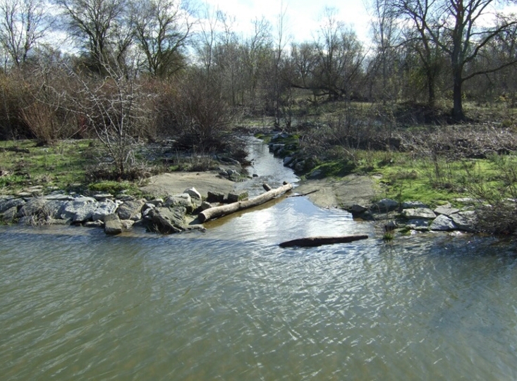
Photo on wier

Photo above looking South from top of weir toward target pond
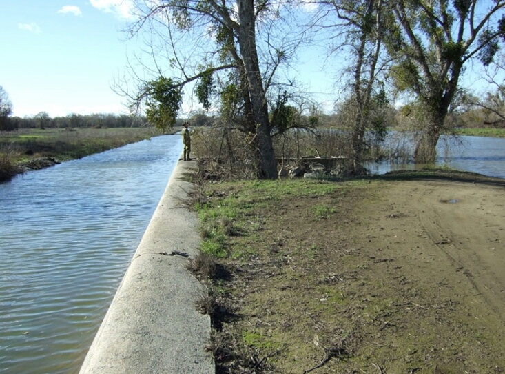
Photo of fish ladder

Ladder in center of photo. Bypass and apron to the left; River to the right (100 Yds).

  1. http://calsport.org/fisheriesblog/?p=497; http://calsport.org/fisheriesblog/?p=421
  2. Thomas, M. J., and others. 2013.  Stranding of Spawning Run Green Sturgeon in the Sacramento River: Post-Rescue Movements and Potential Population-Level Effects.  North American Journal of Fisheries Management 33:287–297.  ISSN: 0275-5947 print / 1548-8675 online. DOI: 10.1080/02755947.2012.75820.

Salmon Rescue in Yolo Bypass

A December 23, 2015 article in the Sacramento Bee1 describes salmon rescues occurring in the northern Yolo Bypass near the outlet of the Knights Landing Ridge Cut. The online SacBee article provides a video of the trapping and hauling process. I posted earlier about the stranding of salmon in the Bypass.2

It is encouraging that the California Department of Fish and Wildlife is addressing the immediate situation and that this effort is getting coverage in the press. However, the SacBee article contains several misconceptions about the problem:

  1. “Salmon are having problems with the drought identifying which route to go right now.” This problem is by no means unique to the drought. This stranding problem is far worse in wetter years when higher flows into the Yolo Bypass and Colusa Basin Drain attract far more salmon (and steelhead and sturgeon).
  2. “Beginning in 2013…” – the problem has been known for many decades.
  3. “That spring, biologists discovered that some 600 endangered winter-run salmon had gotten trapped 70 miles off course in the Colusa Basin Drain system” – the estimate was very rough, given that the agencies acknowledged the problem late in spring and surveyed only a few areas of the Colusa Basin. In addition, they were unable to count all the fish concentrations and to identify the genetics of all the fish.
  4. “Although conservationists captured and returned many of the fish to the river” – though the effort was commendable, many of the stray fish were not captured and returned.
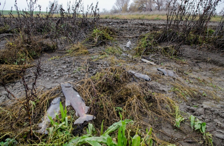
  5. “Since then, we’ve started building seasonally these traps that we can put in the channel to allow us to move them pretty efficiently” – when flows got high last winter in the Colusa Basin Drain, the trap was removed because it was ineffective. Many salmon passed the trap location (to die upstream in the Colusa Basin), and hundreds were stranded nearby and died (see photo below).
  6. “The traps are a temporary solution, but efforts are underway to permanently stop the fish from going off-course.” – The traps are better described as a Band-Aid than a solution. They do not work at higher flows when fish passage is greatest. Permanent solutions were prescribed in the 2008 National Marine Fisheries Service Biological Opinion for operation of the federal Central Valley Project and the State Water Project. If a permanent solution is in fact completed next summer as the SacBee article suggests, it can’t be soon enough.
Picture of stranded salmon

Salmon stranded at Knights Landing Ridge Cut Outlet in northern Yolo Bypass after high flows in December 2014.

It is Too Early to Turn On the Delta Pumps

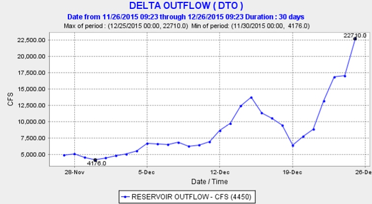
Delta export pumping has increased, jeopardizing endangered Winter Run salmon and Delta smelt. Yes, there is a lot of fresh water (and young salmon) pouring into and through the Delta from the recent storms. Delta outflow has risen from 5000 cfs to 22,700 cfs this month (Figure 1). So the state has started pumping more from the south Delta. State exports have risen from 500 cfs on 12/21 to 4000 on 12/23.

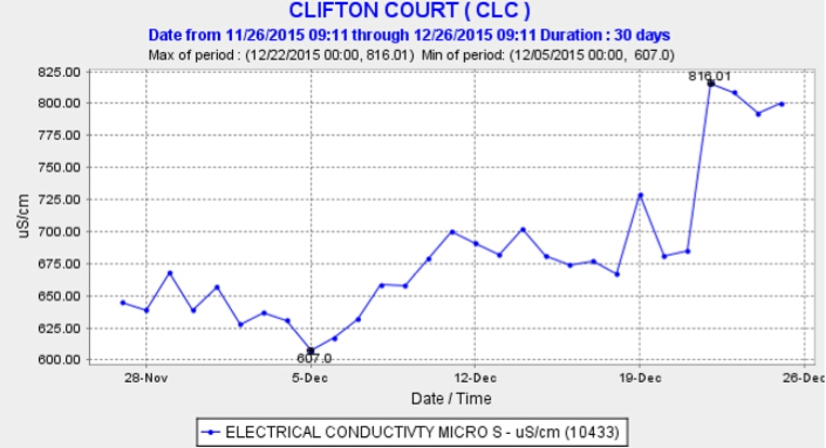
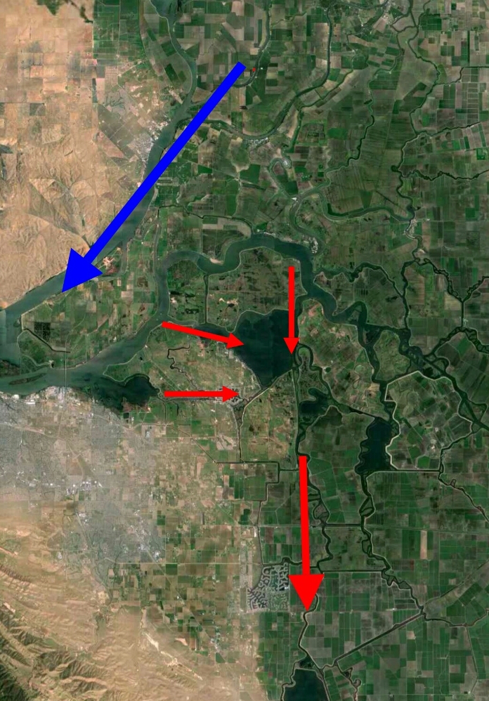
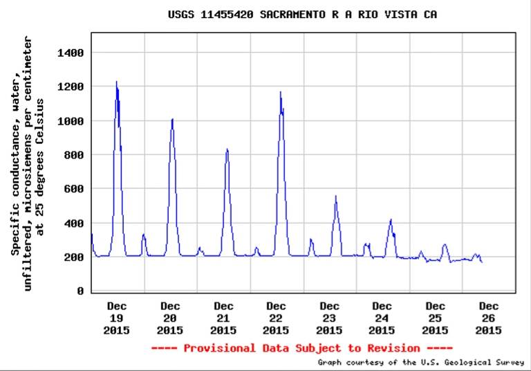
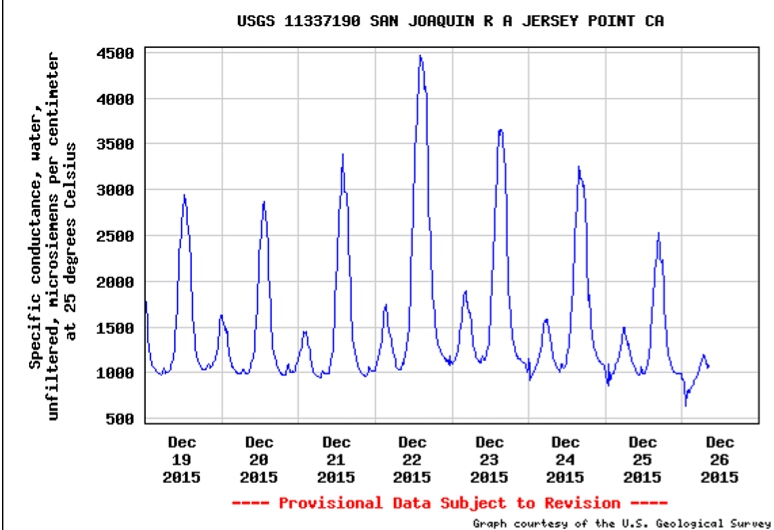
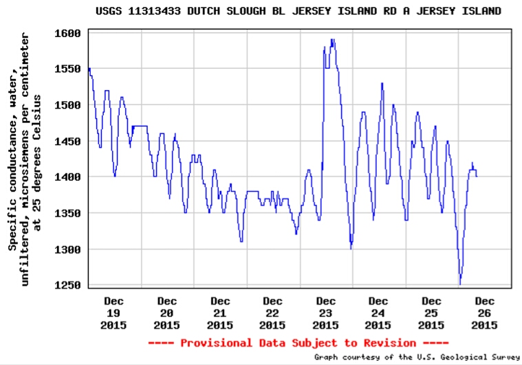
The problem is that the Low Salinity Zone (LSZ, 500-10,000 EC1) so critical to the Delta ecology has yet to be flushed west, out of the Delta. Turning up the pumps has actually increased the concentration of salt in export water (Figure 2) by pulling LSZ water from the north and west into the central and south Delta (Figure 3). Smelt and salmon concentrate in this zone. The LSZ has moved west from Rio Vista in the north Delta on the Sacramento River (Figure 4), but not from the west and central Delta on the San Joaquin side (Figure 5). Export pumps in the south Delta are pulling LSZ waters from the San Joaquin channel through False River and Dutch Slough (Figure 6).

Remnants of the Delta smelt population are in the central Delta.2 Winter Run salmon smolts began showing up at the export fish facilities in Clifton Court on 12/23. Both occurrences should be a stern warning, given the present poor state of these two endangered fish populations. Closure of the Delta Cross Channel earlier in December to protect migrating salmon actually aggravated the problem by limiting flushing of the central and west Delta and by trapping salmon and smelt in the central Delta. Exports should not be increased until the LSZ is west of Jersey Point. The Delta Cross Channel should remain open until the LSZ is west of Jersey Point. It is better for everyone if exports are pumping fresh water (

Graph of Delta outflow 2015

Figure 1. Delta outflow in December 2015.

Graph showing Electrical Conductivity at Clifton Court

Figure 2. EC of water exported from Clifton Court Forebay in south Delta in December 2015.

Map of flows

Figure 3. Aerial photo of Delta showing high Delta freshwater inflow and outflow from Sacramento River (blue arrow) and South Delta exports pulling brackish Low Salinity Zone water from central and west Delta San Joaquin channel to south Delta export pumps at Clifton Court Forebay (center bottom). The two eastward red arrows represent the False River (upper arrow) and Dutch Slough connections.

Graph of electrical conductivity at Rio Vista

Figure 4. EC at Rio Vista in north Delta on Sacramento River 12/19-12/26, 2015.

Graph of electrical conductivity at Jersey Point

Figure 5. EC at Jersey Point in the western Delta on San Joaquin River 12/19-12/26, 2015.

Graph of electrical conductivity at Dutch Slough

Figure 6. EC at Dutch Slough between the west and central Delta 12/19-12/26 2015. Note spike on 12/23 when south Delta exports were increased to 4000 cfs.

  1. EC is electrical conductivity expressed as microsiemens
  2. http://calsport.org/fisheriesblog/?p=570

Scott River – Crisis Update

In a recent post1 I related that the Scott River, a major salmon producing Klamath tributary in northern California near Yreka and Fort Jones, is again in crisis due to low fall flows in the present drought. I suggested that normal December storms might be too late to save the Fall Run Chinook, but would likely accommodate the later spawning Coho.

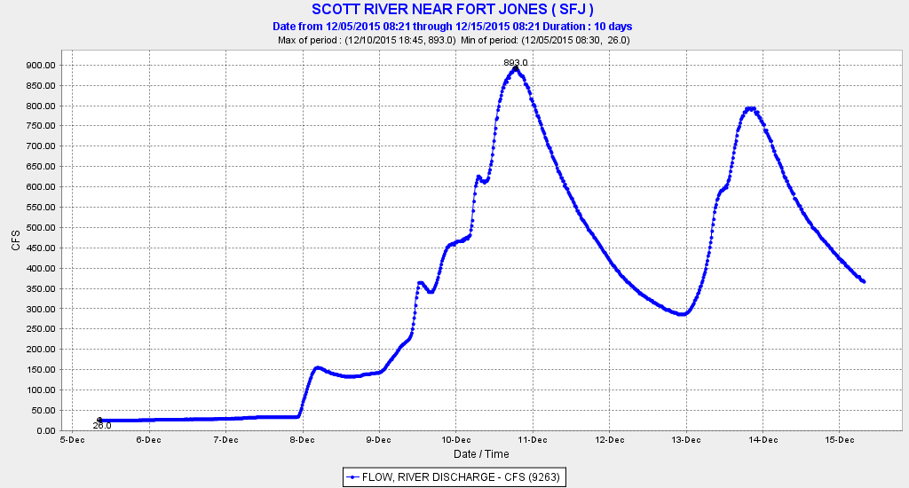
Two December storms (Figure 1) have come and helped the salmon. Counts near Fort Jones recently reached near 400 for Chinook and 200 for Coho. Neither number is good, but the Chinook number, though preliminary, is very low, as it should be several thousand or more. Waiting for several months to ascend the river to spawn has likely taken its toll on the Chinook. The storms were also nearly too late for Coho, but these circumstances are fairly normal for Coho.

Graph of December streamflow in Scott River below Fort Jones

Figure 1. December streamflow in Scott River below Fort Jones. (Source: CDEC)

The late storms made things very difficult for Chinook. In a recent newspaper article2 on the Scott, it was noted that late runs usually spawn in the lower river, downstream of the good spawning reaches. The lower river spawning grounds are subject to winter storm scouring. In the article, some sources blamed the low fall flows on agricultural groundwater pumping during the summer and fall, which lowered the water table in Scott Valley. Lack of summer snow storage in the adjacent mountain ranges was also a key factor.

But the article and its sources miss what my previous post suggested as a solution to the problem. Groundwater could have been pumped into the river in the Valley in substantial amounts in the fall using some of the irrigators’ idle pumps. A concerted pumping effort in October and November, for one to several weeks, could have gotten the Chinook up from the mouth into the Valley to the perennial flowing spawning tributaries and river reaches. The salmon could have spawned or have been ready to spawn when the rains did come.

The winter rains are already recharging the groundwater basin in the Scott Valley, so the costs of the effort in terms of next year’s water supply would have been minimal. The cost of electricity is minuscule in comparison with the loss of production of one of the Klamath’s most prolific salmon-producing tributaries.

Some Delta Smelt Back in the Delta

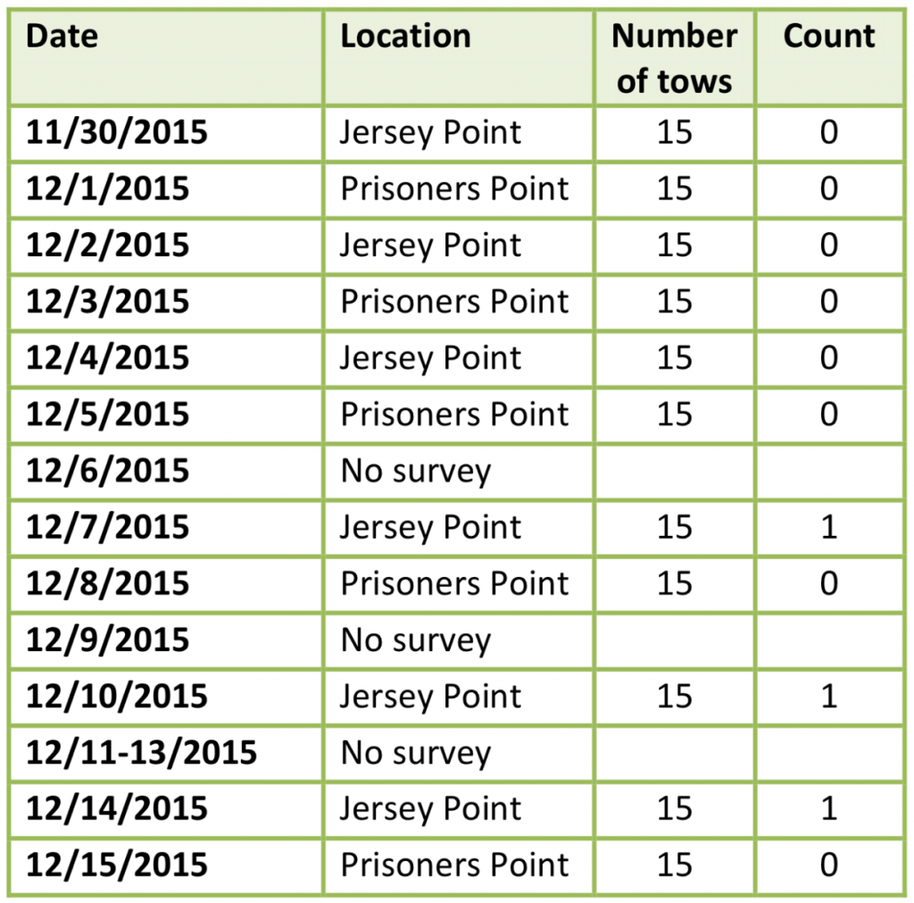
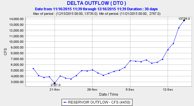
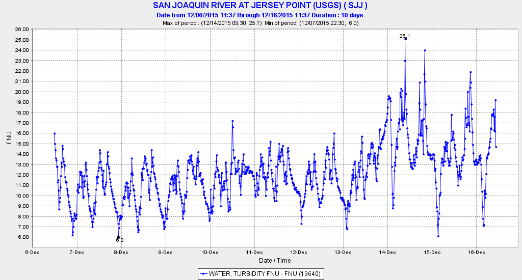
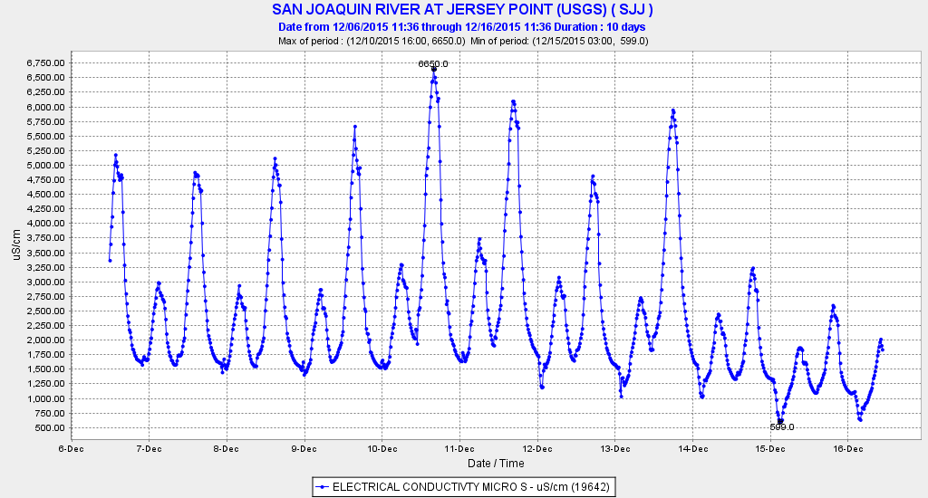
The US Fish and Wildlife Service’s early winter survey1 recently detected the first adult Delta Smelt of the water year in the Delta at Jersey Point on the lower San Joaquin River (Figure 1). The number collected in the survey through December 15th is 3, compared to 26 for the same period last year. Their appearance is on schedule and likely related to the first storm flow of the winter (Figures 2 and 3), and the freshening of the Delta (Figure 4).

Table of Smelt Count

Figure 1. Catch of adult Delta Smelt in early warning survey at two lower San Joaquin River stations in December 2015.

Graph of Delta freshwater outflow in December 2015

Figure 2. Delta freshwater outflow in December 2015. (Source: CDEC)

Graph of Turbidity of water at Jersey Point in December 2015

Figure 3. Turbidity of water at Jersey Pt in December 2015. (Source: CDEC)

Graph of Salinity (EC) at Jersey Point in December 2015

Figure 4. Salinity (EC) at Jersey Pt in December 2015. (Source: CDEC)