Experiment – Part 2 Yolo Bypass Flow

Recently I posted about an unprecedented experiment being undertaken as part of the State’s new Delta Smelt Resiliency Strategy July 2016. That experiment now underway (“Experiment 1”) involves increasing Delta outflow in the latter part of July, 2016. The Strategy also included the North Delta Food Web Adaptive Management Projects (“Experiment 2”), management actions that would benefit juvenile and sub-adult Delta smelt by enhancing the north Delta forage supply for Delta smelt. Experiment 2 involves enhancing flow through the Yolo Bypass to the north Delta by closing the Knights Landing Outfall Gates and routing water from the Sacramento River at Hamilton City (GCID intakes) via the Colusa Basin Drain system into the Yolo Bypass to promote food production in areas where Delta smelt are known to occur. The objective of Experiment 2 is to enhance flow and increase nutrient inputs into the tidal north Delta in the Cache Slough-Lower Bypass region. Future food web enhancement flows would also be considered for “additional months in ways that will not conflict with agricultural and waterfowl management actions based on the availability of water to augment flows in the Yolo Bypass. DWR will also explore options for increasing outflow from the Yolo Bypass during the spring.” Experiment 2 also commenced in July 2016 as an “Emergency Action to Help Delta Smelt”.

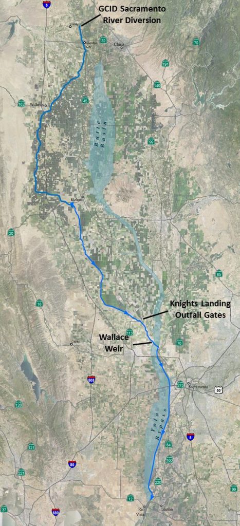
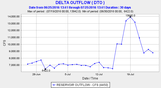
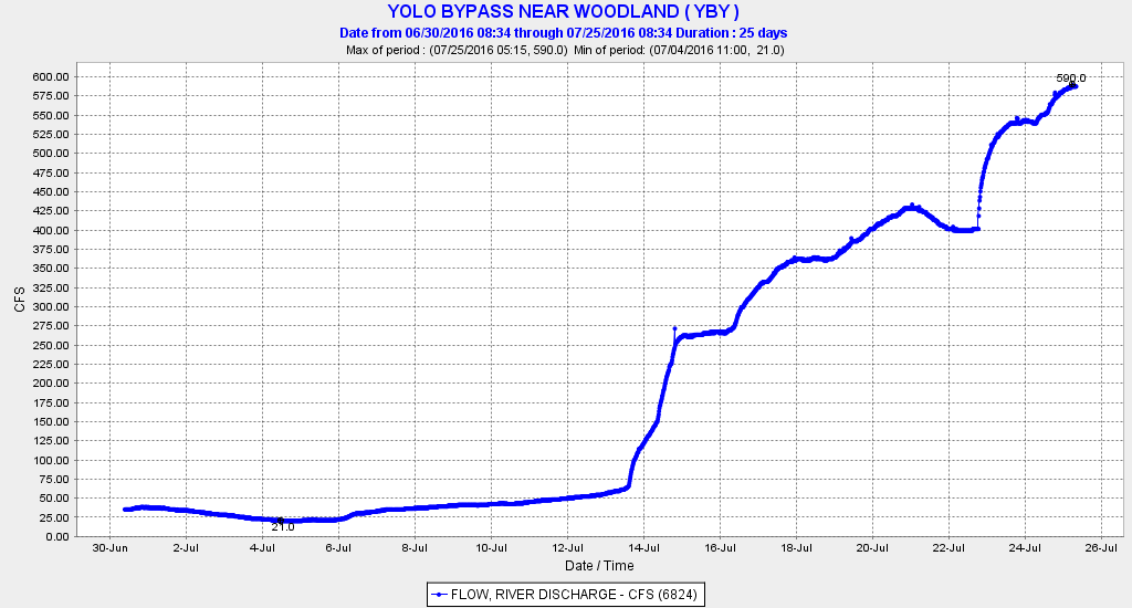
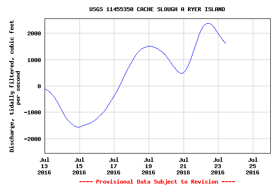
As it turned out, the two experiments were timed together, probably to complement one another. Colusa Basin Drain flows increased in mid-July in Experiment 2 via diversion from GCID intakes at Hamilton City (Figure 1). Delta outflow (Figure 2) was increased in Experiment 1 by reducing Delta exports on July 15. Flow through the Yolo Bypass was increased (Figure 3) by closing the Knights Landing Outfall Gates from the Colusa Basin Drain to the Sacramento River and routing the flow through the Knights Landing Ridge Cut to the upper Yolo Bypass on down to Cache Slough and the North Delta (see route in Figure 1). Net flow through lower Cache Slough (Figure 4) increased from the combined effect of the higher flow in Yolo Bypass and the increased flow through Miners Slough and Steamboat Slough that resulted from reduced exports.

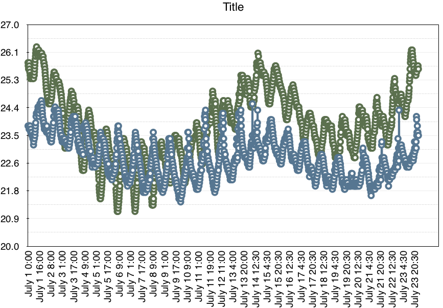
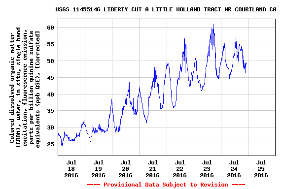
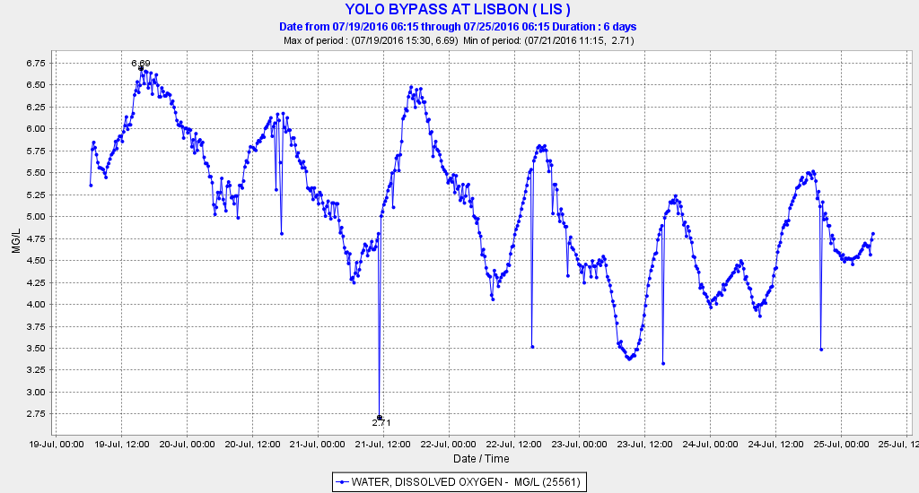
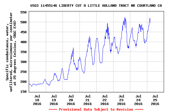
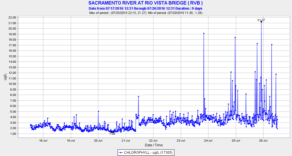
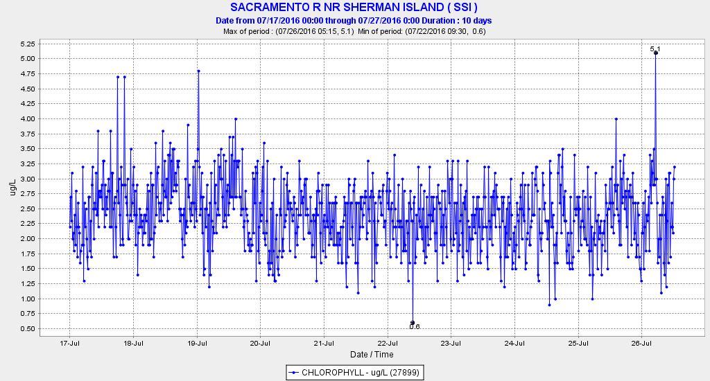
So is Experiment 2 having the desired effects? Water temperature in the upper and lower Bypass continue close to the 80°F mark due to high summer air temperatures, although the water temperature in the lower Bypass’s Tule Canal has been measurably higher than that in the adjacent Ship Channel (Figure 5). The higher flow in the Tule Canal likely carries a high organic load as is evident in the low night-time dissolved oxygen levels of 3 to 5 mg/l (Figure 6). Concentrations of salts (Figure 7) and organic matter (Figure 8) increase in the lower Bypass with higher flow. Plankton productivity as measured by chlorophyll levels in the lower Sacramento River channel at Rio Vista immediately below Cache Slough, though low (<10 micro-grams per liter), shows signs of increasing (Figure 9). However, several miles downstream in the channel at Sherman Island, there has been no sign of an increase in plankton (Figure 10). If an increase is indeed real, it is not clear if it is being caused by the higher Delta outflow, lower Delta exports, higher flow in the Bypass, or some combination thereof.

All in all, the warm nutrient- and organic-laden 500-600 cfs of water from the Colusa Basin agricultural drain moving down the Bypass appears to reach the tidal lower Bypass/Cache Slough complex. There, it mixes with higher net and tidal flows of Cache Slough and the Sacramento River. With 80,000 to 100,000 cfs going back and forth during the twice daily tide cycle between Cache Slough and Rio Vista, the Colusa Basin water from the Yolo Bypass is quickly mixed, and its signature is lost. The key question: is there sufficient “fertilizer” and extra plankton in this foreign water to stimulate plankton food production in the lower Yolo Bypass, Cache Slough and the north Delta to benefit Delta smelt? A reduction in river flow at Hamilton City from Experiment 2 might be considered an impact to Sacramento River fish unless additional water is specifically released from Shasta Reservoir for the experiment, or unless GCID water contractors forgo use of a portion of their allocated diversion at Hamilton City.

At a minimum, Experiment 2 has proved the efficacy of an action that might be even more effective from late fall to early spring when water used to stimulate plankton production in the Delta would augment the benefits of cooler, higher flows in the Sacramento River.

Figure 1. Path of flows diverted from the Sacramento River near Hamilton City. Water will move down through GCID's system, into the Colusa Basin Drain and Knights Landing Ridge Cut, through Wallace Weir and the Yolo Bypass, and into the Delta near Rio Vista. Source: http://www.norcalwater.org/wp-content/uploads/Smelt-action-fact-sheet.pdf

Figure 1. Path of flows diverted from the Sacramento River near Hamilton City. Water will move down through GCID’s system, into the Colusa Basin Drain and Knights Landing Ridge Cut, through Wallace Weir and the Yolo Bypass, and into the Delta near Rio Vista. Source: http://www.norcalwater.org/wp-content/uploads/Smelt-action-fact-sheet..pdf

Figure 2. Delta outflow July 2016.

Figure 2. Delta outflow July 2016.

Figure 3. Flow in the upper Yolo Bypass near Woodland July 2016.

Figure 3. Flow in the upper Yolo Bypass near Woodland July 2016.

Figure 4. Net tidally filtered flow in lower Cache Slough July 2016.

Figure 4. Net tidally filtered flow in lower Cache Slough July 2016.

Figure 5. Water temperature at adjacent stations in the lower Bypass Tule Canal (GREEN) and Ship Channel (BLUE) during July 2016.

Figure 5. Water temperature at adjacent stations in the lower Bypass Tule Canal (GREEN) and Ship Channel (BLUE) during July 2016.

Figure 6. Dissolved oxygen level in the Yolo Bypass Tule Canal at Lisbon 19-25 July 2016.

Figure 6. Dissolved oxygen level in the Yolo Bypass Tule Canal at Lisbon 19-25 July 2016.

Figure 7. Specific conductance of water in the lower Yolo Bypass at Liberty Cut late July 2016.

Figure 7. Specific conductance of water in the lower Yolo Bypass at Liberty Cut late July 2016.

Figure 8. Concentration of dissolved organic matter in lower Yolo Bypass at Liberty Cut late July 2016.

Figure 8. Concentration of dissolved organic matter in lower Yolo Bypass at Liberty Cut late July 2016.

Figure 9. Chlorophyll concentrations in the lower Sacramento River in north Delta at Rio Vista 18-28 July 2016.

Figure 9. Chlorophyll concentrations in the lower Sacramento River in north Delta at Rio Vista 18-28 July 2016.

Figure 10. Chlorophyll concentrations in the lower Sacramento River in north Delta at Sherman Island 17-28 July 2016.

Figure 10. Chlorophyll concentrations in the lower Sacramento River in north Delta at Sherman Island 17-28 July 2016.

Sac River Salmon Opener a Bust

The salmon season on the lower Sacramento River opened on July 16 with a yawn. As described in the Chico Enterprise, “the salmon aren’t biting”. One fish was confirmed caught. The article paraphrased an analysis by CDFW biologist Rob Titus, who referred to a plan to hold back releases from Shasta Reservoir to help juvenile salmon to migrate to the ocean. The article also stated that “the drought has had a deep impact on the fish population.”

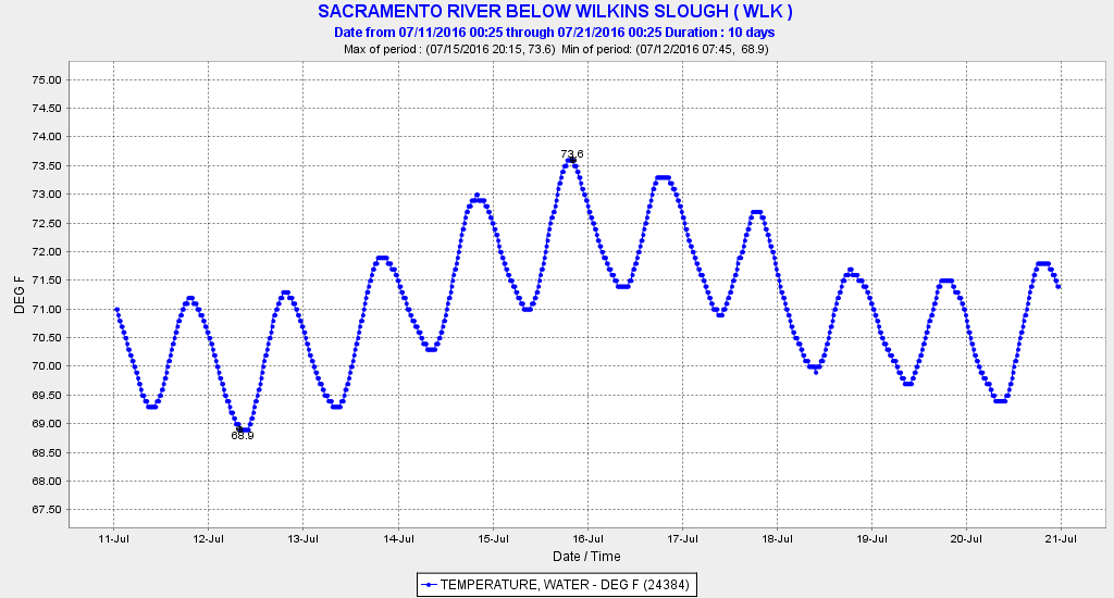
CDFW could have told everyone to stay home. The river flow was too low and the water temperatures were too high for salmon to move up the river. In a July 2 post, I warned about the low flows and warm water. In the lower river, flow was only 4000 cfs. Water temperature reached 72-74°F on opening day (see chart below), high enough to block migrating salmon. No CDFW biologist mentioned that while 10,000 cfs was being released from Shasta at the time, only 4,000 cfs was reaching the lower river.1 No one mentioned that the State Water Board is not enforcing the State standard of 68°F for the lower Sacramento.

image1

  1. As of 7/23, Sacramento River flow below Wilkins Slough had increased only slightly, to about 4400 cfs.

An Unprecedented Experiment – July 2016

State’s Delta smelt plan calls for more water flowing to sea” – This headline to a recent Sacramento Bee article speaks of the state and federal governments’ hope to get more water for Delta outflow to the Bay this summer to help Delta smelt after four devastating drought years.  Smelt are at record lows, and their endangered status under the state and federal endangered species acts requires an effort to help recover them.  When the Delta smelt plan was announced, this year’s Summer Delta Smelt Index had just come in at 0.0, the same as it was last summer.

A grand experiment began on July 15.  With Shasta Reservoir releases held low to save cold water for salmon, more Delta outflow for the experiment was provided by reducing exports from 9000 cfs to 2000 cfs.  Deliveries to South-of-Delta CVP and SWP contractors were cut to a minimum, even though the plan had promised: “[no] cuts to water supply planned.”

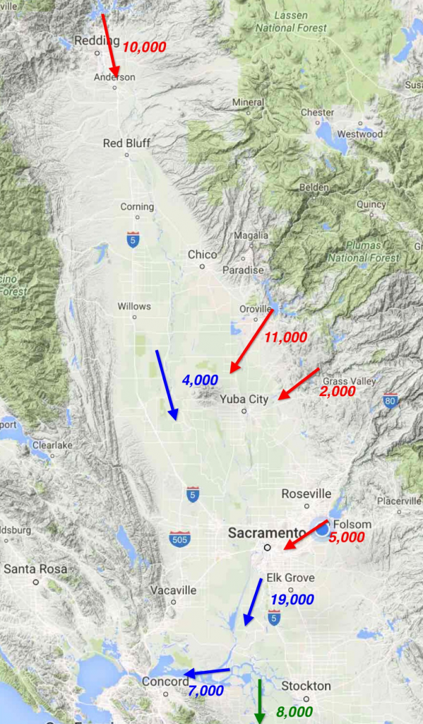
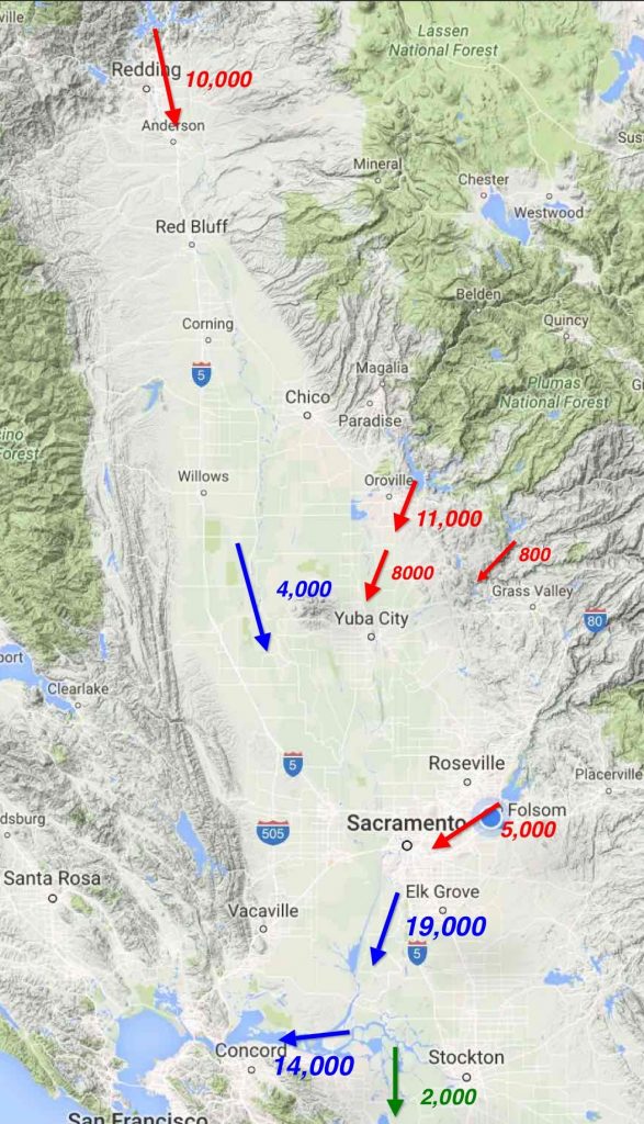
Conditions on July 12 can be seen in Figure 1.  Reservoir releases and some natural river flow totaled approximately 30,000 cfs.  Most (80%) of the 20,000 cfs of Delta inflow was coming from Oroville and Folsom reservoirs.  Of that amount, only 7000 cfs was leaving the Delta for the Bay (the required minimum outflow in July of a Below Normal year under state standards is 6500 cfs).  Approximately 6,000 cfs was being diverted from the upper Sacramento River below Redding.  Another 3,000 cfs was being diverted from the lower river and its tribs.  Another 4,000 cfs was diverted in the Delta.  Finally, the state SWP was pumping 7000 cfs and federal CVP was pumping 1000 cfs from the south Delta.

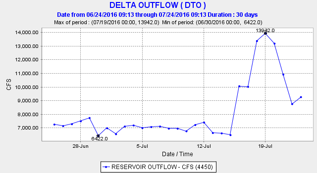
By July 15, conditions in the Delta changed.  Delta outflow doubled, while exports were reduced by 80% (Figure 2).

We often hear about “adaptive management” to test things to see if they help or not.   This is a big, very unprecedented adaptive management experiment.  The purpose is to help Delta smelt recover from a dramatic decline over the past two decades.  However, it will be difficult to help what is not there. There were few smelt out there a month ago; hopefully, there are still enough that the experiment will make a difference.

The important thing now with such an experiment is to make sure we learn everything we can from it.  The following are some questions that should be addressed.

  1. What changes occur in flow, nutrients, salinity and water temperature in the Delta and Bay?
  2. If there are no Delta smelt, what changes occur to the other pelagic organisms such as phytoplankton, zooplankton, shrimp, longfin smelt, striped bass, herring, anchovy, and threadfin shad?
  3. Will the change stimulate a plankton bloom that benefits the Bay-Delta estuary?

From the point of view of managing the experiment, it is good that other important factors such as Delta inflow remain unchanged, so that there are not too many variables to filter out as determinative in any response.  It will be difficult enough to determine the relative importance of higher outflow versus lower export.

Hydrology

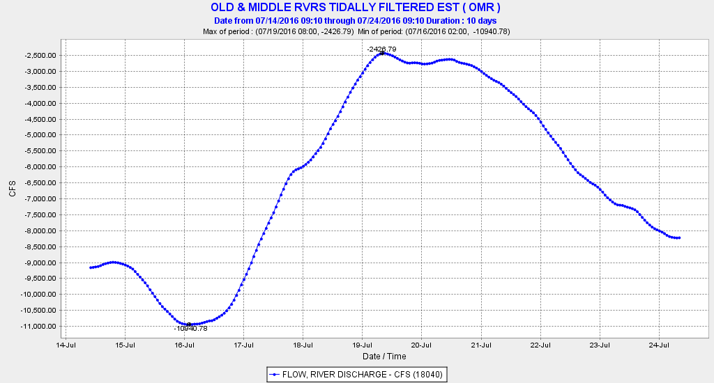
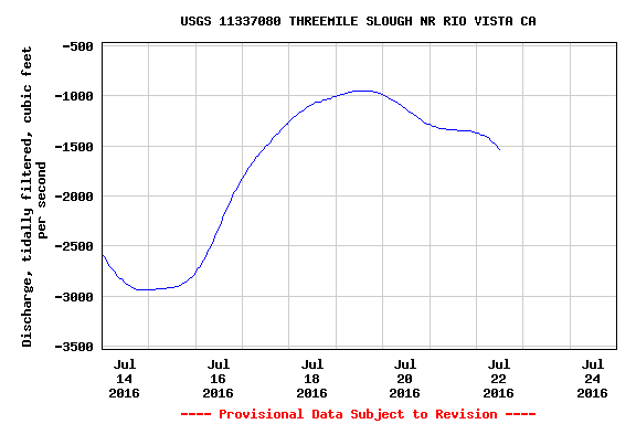
Preliminary results indicate that the experiment (as expected) had a noticeable effect on Delta hydrology.  By July 24, outflow had dropped back from its peak during the experiment of 14,000 cfs to 9000 cfs (Figure 3), as exports were again increased to about 7000 cfs, as shown in Old and Middle River tidally averaged flow (Figure 4).  Net lower San Joaquin River flow at Jersey Point initially increased sharply in response to the reduced exports (Figure 5).  The net flows diverted from the lower Sacramento to the lower San Joaquin via Threemile Slough were also reduced (Figure 6).

Salinity

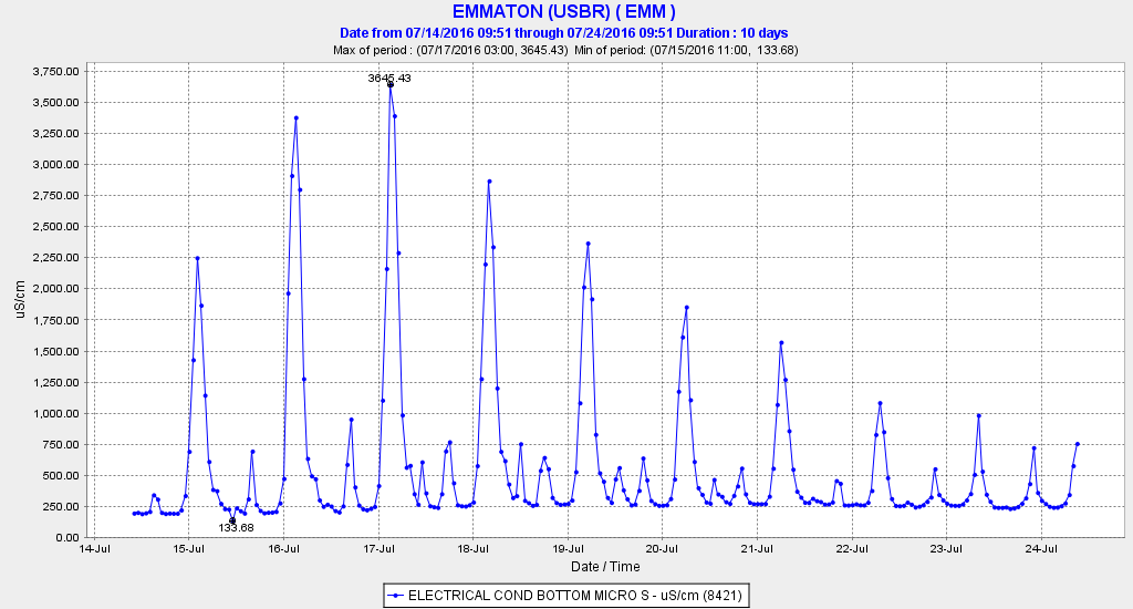
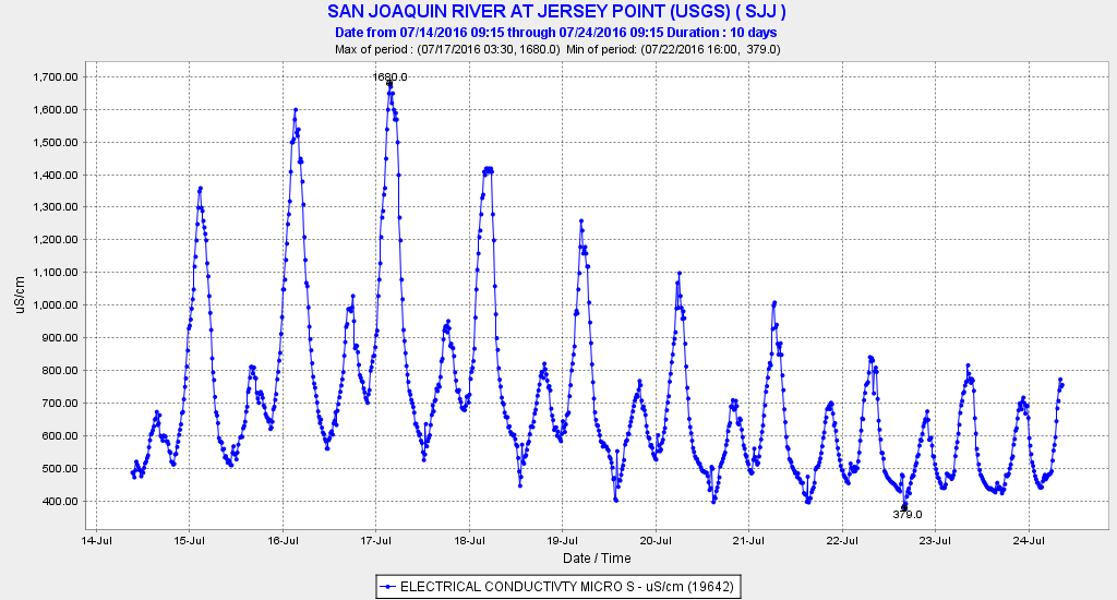
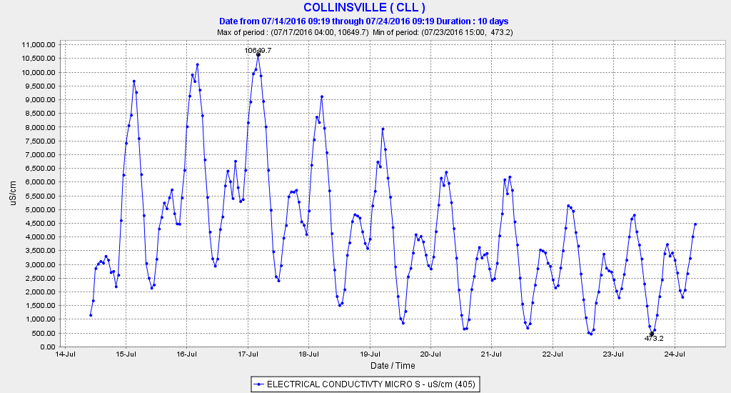
Salinity (EC) eventually responded to the higher outflows as the pulse of freshwater pushed westward.  Salinity on the lower Sacramento at Emmaton (Figure 7) and Jersey Point on the lower San Joaquin (Figure 8) declined measurably.  Salinity also declined downstream at the confluence of the two rivers near Collinsville in eastern Suisun Bay (Figure 9).

Water Temperature

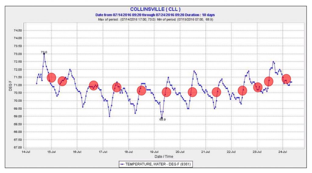
There has been slightly lower water temperature in the western Delta.  This is at least partially explained by cooler air temperatures during the experiment.  The water temperature at X2 (location of 2 ppt salinity or 2700 EC declined as X2 was located on-average further west during the experiment  (Figure 10).  However, that too could be explained by lower air temperatures.

Plankton Blooms

So far there is no evidence of enhanced plankton production by the experiment.  There has been little change in chlorophyll measured at selected gaging stations in the central and west Delta.

Fish

While results of Delta-wide fish surveys will not be available for some time, results of export salvage of two pelagic Delta species, striped bass and threadfin shad, showed sharp reductions as expected (Figures 11 and 12).

Figure 1. Water conditions in mid July 2016 in the Sacramento Valley and Delta before the experiment. Red denotes major water releases in cfs from the Valley’s four largest reservoirs. Blue denotes three key river flow locations: lower Sacramento River upstream of the Feather River, Freeport coming into the Delta, and Delta outflow. Green denotes south Delta exports.

Figure 1. Water conditions in mid July 2016 in the Sacramento Valley and Delta before the experiment. Red denotes major water releases in cfs from the Valley’s four largest reservoirs. Blue denotes three key river flow locations: lower Sacramento River upstream of the Feather River, Freeport coming into the Delta, and Delta outflow. Green denotes south Delta exports.

Figure 2. Flow conditions in the Sacramento Valley and Delta on 20 July 2016. Delta outflow is 14,000 cfs. Sacramento River flow above the mouth of the Feather River was 4,000 cfs. Sacramento River inflow to the Delta at Freeport is 19,000 cfs. (Note total Delta inflow was about 20,000 cfs. Total Central Valley reservoir releases and uncontrolled river inflows was over 30,000 cfs.). About two-thirds of the Delta inflow came from Feather Riverand American River reservoirs. Though only 2000 cfs was being exported from the south Delta projects, approximately 14,000 cfs of Sacramento Valley reservoir releases were being diverted for water supply from Sacramento Valley rivers and the interior Delta. Nearly all San Joaquin Valley reservoir releases were being diverted.

Figure 2. Flow conditions in the Sacramento Valley and Delta on 20 July 2016. Delta outflow is 14,000 cfs. Sacramento River flow above the mouth of the Feather River was 4,000 cfs. Sacramento River inflow to the Delta at Freeport is 19,000 cfs. (Note total Delta inflow was about 20,000 cfs. Total Central Valley reservoir releases and uncontrolled river inflows was over 30,000 cfs.). About two-thirds of the Delta inflow came from Feather Riverand American River reservoirs. Though only 2000 cfs was being exported from the south Delta projects, approximately 14,000 cfs of Sacramento Valley reservoir releases were being diverted for water supply from Sacramento Valley rivers and the interior Delta. Nearly all San Joaquin Valley reservoir releases were being diverted.

Figure 3. Delta outflow increased to 14,000 cfs during the July 15-23 experiment.

Figure 3. Delta outflow increased to 14,000 cfs during the July 15-23 experiment.

Figure 4. The tidally filter flow in the central Delta showed about a 6500 cfs reduction in the flow in Old and Middle River toward the south Delta export pumps.

Figure 4. The tidally filter flow in the central Delta showed about a 6500 cfs reduction in the flow in Old and Middle River toward the south Delta export pumps.

Figure 5. The experiment brought a sharp response in the tidally filtered flow at Jersey Point in the lower San Joaquin River in the western Delta.

Figure 5. The experiment brought a sharp response in the tidally filtered flow at Jersey Point in the lower San Joaquin River in the western Delta.

Figure 6. The experiment brought a reduction in net flows pulled from the lower Sacramento River to the lower San Joaquin via Threemile Slough.

Figure 6. The experiment brought a reduction in net flows pulled from the lower Sacramento River to the lower San Joaquin via Threemile Slough.

Figure 7. Salinity (EC) at Emmaton on the lower Sacramento River just north of Antioch 14-24 July, 2016.

Figure 7. Salinity (EC) at Emmaton on the lower Sacramento River just north of Antioch 14-24 July, 2016.

Figure 8. Salinity (EC) at Jersey Point on the lower San Joaquin River near Antioch 14-24 July, 2016.

Figure 8. Salinity (EC) at Jersey Point on the lower San Joaquin River near Antioch 14-24 July, 2016.

Figure 9. Salinity (EC) at Collinsville near the confluence of the lower Sacramento and San Joaquin channels in eastern Suisun Bay 14-24 July, 2016.

Figure 9. Salinity (EC) at Collinsville near the confluence of the lower Sacramento and San Joaquin channels in eastern Suisun Bay 14-24 July, 2016.

Figure 10. Water temperature (F) at Collinsville in eastern Suisun Bay 14-24 July, 2016. Red dots indicate water temperature when X2 was located at Collinsville

Figure 10. Water temperature (F) at Collinsville in eastern Suisun Bay 14-24 July, 2016. Red dots indicate water temperature when X2 was located at Collinsville

Figure 11. Salvage of striped bass at south Delta export facilities July 1-20, 2016.

Figure 11. Salvage of striped bass at south Delta export facilities July 1-20, 2016.

Figure 12. Salvage of threadfin shad at south Delta export facilities July 1-20, 2016.

Figure 12. Salvage of threadfin shad at south Delta export facilities July 1-20, 2016.

State Comes Through With Lower Exports

On July 12, the State came out with its plan to save smelt by reducing Delta exports and increasing Delta freshwater outflow. The next day, exports were increased 1000 cfs (from 8000 to 9000 cfs) and outflow was reduced 1000 cfs to 3000 cfs as measured by USGS. But on July 17, the State finally came through. The State dropped State Water Project (SWP) exports from 7000 to 4000, and the feds dropped Central Valley Project (CVP) exports from 1,600 to 800. Then on July 19, combined exports dropped another 3000 cfs, to less than 2000 cfs. Delta outflow is now nearly 14,000 cfs, the level it was in late July 2011, the last wet year. Though the change may have come too late, we will see come fall any response in the indices for longfin smelt and Delta smelt.

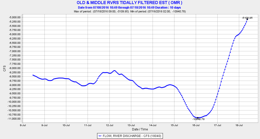
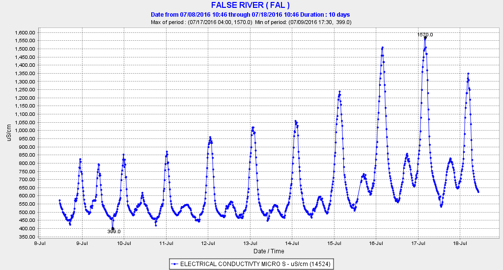
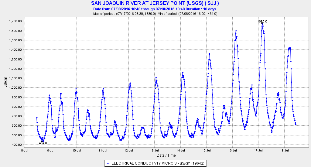
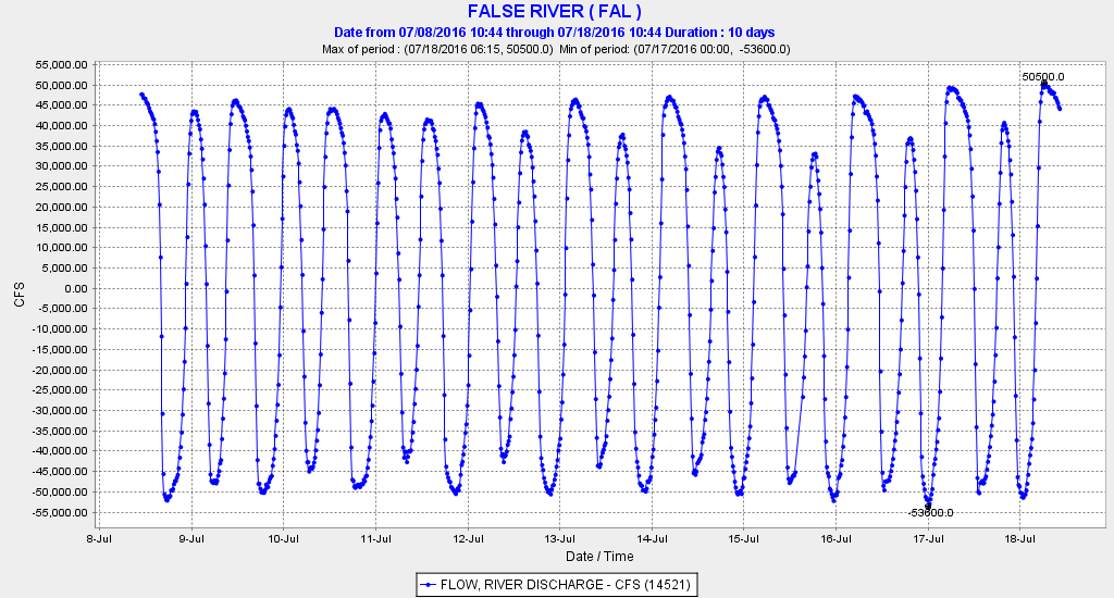
The flow response showed up immediately in flow gages in Old and Middle Rivers, where flows of minus 11,000 dropped to minus 5,000 cfs (Figure 1). The response in salinity levels will take a few days, but it’s already showing up in the western Delta at False River (Figure 2) and Jersey Point (Figure 3). Even in the smaller confines in False River, the effect of the change is hard to perceive over the effect of tides (Figure 4), but it is there. Eventually, the higher freshwater outflow will push the salt westward.

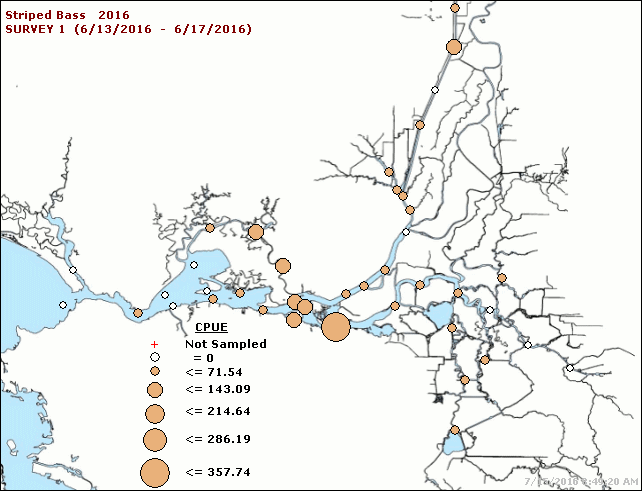
The first measure of progress should appear in surveys 5 and 6 of the Summer Townet Survey. Because there are few smelt left from which to observe a response, a response will be most noticeable in striped bass. We should be able to see a change to a more westward distribution of the Low Salinity Zone and striped bass juveniles (Figure 5).

Flow Graph

Figure 1. Hourly flow in Old and Middle Rivers combined in the central Delta from July 8 to July 18, 2016.

Salinity graph

Figure 2. Salinity (EC) in False River in western Delta from July 8 to July 18, 2016.

Electrical conductivity graph

Figure 3. Salinity (EC) in lower San Joaquin River at Jersey Point in western Delta from July 8 to July 18, 2016.

Flow Graph

Figure 4. Hourly flow in False River in western Delta from July 8 to July 18, 2016.

Map of striped bass choice

Figure 5. Townet survey 1 catch of striped bass June 2016.

Increasing Salmon Rearing Habitats in the Upper Sacramento River – A Long-Overdue Management Action

Large amounts of rearing habitats for young salmon were lost in the upper Sacramento Valley Basin when Shasta and Keswick Dams were built. Loss of this rearing habitat (located in smaller, shallower river channels upstream of the dams – like the McCloud River) was considered one of the numerous reasons for the listing of the winter-run Chinook as endangered. Since dam construction, young salmon emerging from main-stem spawning areas downstream of the dams must now contend with the severe rigors of a large, deep river channel. It is generally acknowledged that the quality of rearing habitats in those upstream areas was superior to habitats below the dams (Vogel 2011).

Although significant efforts have been made to increase the quantity and quality of spawning habitats below the dams, minimal progress has occurred on rearing habitats. Massive amounts of spawning gravels have been added to the upper Sacramento River downstream of Keswick Dam, but there are indications that rearing habitats may be an equally important, if not more-important, factor limiting the fish populations. As pointed out by the U.S. Fish and Wildlife Service (USFWS),“ … there would be little value in increasing the quantity of available spawning gravel if the problem that actually limits juvenile production is lack of adequate rearing habitat” (USFWS 1995). Astonishingly, more than two decades later and despite over 1 billion dollars spent on salmon restoration, that potential dilemma remains unresolved.

Present-day rearing habitats are considered very limited and predation during juvenile rearing is believed to be a stressor of very high importance (NMFS 2014). The best habitats, in conventional theory, would be on the channel fringes. Indeed, some such areas with desirable attributes do exist, but are sparse. However, due to the nature of the river reach where most winter-run salmon spawn in deep water, many of the ideal habitat characteristics for rearing are lacking (e.g., appropriate velocities and cover). Subsurface structures like woody debris are severely deficient and would be challenging to restore due to lack of significant recruitment and periodic extremely high-flow events (Shasta Reservoir flood-control releases) that would dislodge this essential feature. In many areas where salmon spawn, the river is wide (e.g., 500 feet) and channel edges are deep (Figure 1). Fry emerging from redds in the main-stem riverbed encounter a paucity of velocity and predator refugia. Underwater observations and sonar camera footage near artificial structures in deep water (e.g., bridge piers) have frequently shown extensive salmon rearing activity, but may suggest the fish are utilizing those areas because insufficient other natural structures on the riverbed are limited or absent (Vogel 2011).

Figure 1. Cross-sectional profile of the upper Sacramento River in an area 500 feet wide and 10 feet deep (scale is approximate).

Figure 1. Cross-sectional profile of the upper Sacramento River in an area 500 feet wide and 10 feet deep (scale is approximate).

Based on many years of observations in the main-stem Sacramento River, large schools of young salmon exhibit a very strong affinity for specific habitats unique in a large, deep river channel. This circumstance is a quandary for salmon fry upon emergence from redds positioned in deep water and long distances from channel edges. The weak-swimming fry are immediately exposed to high near-bed water velocities and minimal refugia to escape from predatory fish such as rainbow trout that are very abundant in areas where winter-run Chinook spawn. The region where young salmon have been observed in deep channel areas include behind tail spills of redds and bridge piers, and in eddies adjacent to vertical bedrock walls. It is particularly evident that large schools of salmon choose areas where eddies exist adjacent to high water velocity shear zones. This provides the fish necessary velocity refugia while simultaneously gaining ready access to drift food organisms, thereby minimizing energy expenditure. Unfortunately, those same areas do not provide refuge from predatory fish.

The following are examples of salmon rearing in the deeper waters of the upper Sacramento River. [It must be noted that an enormous amount of sonar camera footage (not shown here) has been taken along near-shore shallow areas that did not show significant rearing utilization.] After viewing each video, stop or click “cancel” on the YouTube player to allow viewing of subsequent videos in this blog entry. For the sonar camera footage, juvenile Chinook can be discerned by largely maintaining their positions in the current, exhibiting visible swimming movements. Ensonified objects moving with the current are debris drifting downstream (e.g., algae and weed fragments).

  • A school of winter-run Chinook fry rearing on the riverbed adjacent to an Interstate-5 bridge pier and woody debris in the Sacramento River at water depths of 10 feet: http://www.youtube.com/watch?v=BP_szST5REo&NR=1
  • School of juvenile Chinook salmon rearing behind a Lake Redding bridge pier in the Sacramento River at water depths approximately 10 feet deep: https://youtu.be/g0dFA8V4-sc
  • School of juvenile Chinook salmon rearing in the Sacramento River in very deep water alongside a vertical bedrock wall and behind woody debris and filamentous algae or weeds: https://youtu.be/Tv0TtOCdzNY
  • School of juvenile Chinook salmon rearing in the Sacramento River behind the remnants of a concrete bridge pier on the riverbed in water depths approximately 12 feet deep with a large fish swimming through the school: https://youtu.be/uAT9Wkx-nSY

An action identified in the 2014 National Marine Fisheries Service (NMFS) Salmon Recovery Plan is: “Using an adaptive management approach and pilot studies, determine if instream habitat for juvenile salmon is limiting salmonid populations, by placing juvenile rearing-enhancement structures in the Sacramento River.” Evaluation of such measures is also a priority in the USFWS Anadromous Fish Restoration Program (USFWS 2001). Most recently, NMFS (2016) identified “a lack of suitable rearing habitat in the Sacramento River” as an “important threat” to winter-run Chinook. Therefore, a proposal to place rearing habitat structures in some deeper-water areas (approximately > 8 feet) of the main-stem upper Sacramento River was recently developed. Using guidance from the California Department of Fish and Wildlife’s (CDFW) Stream Habitat Restoration Manual (CDFW 2010), woody debris heavily anchored to the riverbed using large, angular boulders has been recommended for this initial step and has received favorable response from the fishery resource agencies. Angular boulders would provide the dual benefits of firmly securing woody debris and providing velocity refugia for young salmon; woody debris would provide predator refugia.

It is important to emphasize that this proposal is a pilot project and not intended to create nearshore, shallow-water habitat attributes similar to those that existed in upstream areas prior to dam construction or were lost in downstream riparian areas afterwards. There are already separate plans to construct small, shallow-water side channels in the main-stem river to address that issue. In contrast, this project is intended to place structures in completely different rearing habitat zones in deeper water where large numbers of young salmon have been observed. Given the ecological realities of the specific and unique environmental conditions in the upper Sacramento River, deep-water rearing habitats could very well be one of the most important environmental variables affecting the survival of main-stem spawning salmon progeny. If the pilot project determines high rearing utilization, the project could easily be expanded.

Sites chosen for rearing habitat placement should be in the vicinity and downstream of known spawning sites that are currently lack good rearing habitats. To provide the most benefit to young salmon, placement of rearing structures is focused on the approximate 12-mile reach of the upper Sacramento River below Keswick Dam. This area is where nearly all the endangered winter-run Chinook have been spawning in recent years and also supports the other three Chinook runs as well as the threatened steelhead.

Hopefully, a pilot project will be implemented in early 2017 … stay tuned.

Literature Cited

California Department of Fish and Wildlife. 2010. California Salmonid Stream Habitat Restoration Manual. July 2010. http://www.dfg.ca.gov/fish/Resources/HabitatManual.asp

National Marine Fisheries Service. 2014. Recovery plan for the Evolutionarily Significant Units of Sacramento River winter-run Chinook salmon and Central Valley spring-run Chinook salmon and the Distinct Population Segment of California Central Valley steelhead. California Central Valley Area Office. July 2014. 406 p. http://www.westcoast.fisheries.noaa.gov/publications/recovery_planning/salmon_steelhead /domains/california_central_valley/final_recovery_plan_07-11-2014.pdf

NMFS. 2016. Species in the Spotlight. Priority Actions: 2016 – 2020. Sacramento River Winter-Run Chinook Salmon, Oncorhynchus tshawytscha. 16 p.
http://www.nmfs.noaa.gov/stories/2016/02/docs/sacramento_winter_run_chinook _salmon_spotlight_species_5_year_action_plan_final_web.pdf

U.S. Fish and Wildlife Service. 1995. Working paper: habitat restoration actions to double natural production of anadromous fish in the Central Valley of California. Volume 1. May 9, 1995. Prepared for the U.S. Fish and Wildlife Service under the direction of the Anadromous Fish Restoration Program Core Group. Stockton, CA. https://www.fws.gov/lodi/anadromous_fish_restoration/documents/WorkingPaper_v1.pdf

U.S. Fish and Wildlife Service. 2001. Final Restoration Plan for the Anadromous Fish Restoration Program. A plan to increase natural production of anadromous fish in the Central Valley of California. Released as a revised draft on May 30, 1997 and adopted as final on January 9, 2001. 106 p. plus appendices. https://www.fws.gov/cno/fisheries/CAMP/Documents/Final_Restoration_Plan_for_the_AFRP.pdf

Vogel, D.A. 2011. Insights into the problems, progress, and potential solutions for Sacramento River basin native anadromous fish restoration. Report prepared for the Northern California Water Association and Sacramento Valley Water Users. Natural Resource Scientists, Inc. April 2011. 154 p. http://www.norcalwater.org/wp-content/uploads/2011/07/vogel-final-report-apr2011.pdf