NOAA Advocacy under ESA

On March 31, 2022, the Delta Independent Science Board (ISB) met to discuss: “How the State Water Project and Central Valley Project comply with the Endangered Species Act.”  Cathy Marcinkevage, Assistant Regional Administrator in the California Central Valley Office of the National Oceanic and Atmospheric Administration, NOAA Fisheries division, provided an overview of the federal Endangered Species Act (ESA) and the ESA Section 7 consultation process between NOAA and the Bureau of Reclamation regarding the effects of the Central Valley Project (CVP).

During questions, the ISB’s Dr. Robert Naiman asked if NOAA has “…the legal clout to require dams and other water diversions to install fish passage facilities.”  He provided context, observing: “…[N]one of the dams within the Delta’s watershed have fish passage facilities, and yet you have endangered species that could use the habitat above the dam, assuming you can get them through…” Naiman also noted: “In the Pacific Northwest and elsewhere, there have been a lot of retrofits for fish passage facilities as well as retrofits for regulating water temperatures in the rivers.”

In response, Ms. Marcinkevage spoke to NOAA’s authorities pertaining to fish passage at CVP dams.

First, she mentioned NOAA’s technical criteria for fish passage at intakes at diversion dams’ structures, for example the specifications along the surface of a fish screen: “We do have passage criteria for projects in terms of sweeping velocity and things like that.

Second, she identified NOAA’s authorities under the Federal Power Act to prescribe fish passage at hydropower facilities (which all major Central Valley dams have).  However, this law does not pertain to federal dams, including the CVP dams.

Third, she said that NOAA, under the Federal Endangered Species Act (ESA), can be an advocate during ESA consultation with federal agencies: “With Section 7, we can try to advocate and get projects to do things within our needs.” [Emphasis added]

This is where we take issue with Ms. Marcinkevage.  Under the ESA, NOAA is clearly more than an advocate.  The agency has the principal regulatory authorities and responsibilities to protect and recover ESA-listed anadromous fishes.

NOAA’s job in a Section 7 consultation includes analysis of a project (action) as proposed, which Ms. Marcinkevage described: “But our job there is to analyze the project as it has come to us and identify its likelihood of jeopardizing the species.”  However, the ESA consultation process often also requires changing the details of the proposed project if necessary so that the project complies with the ESA.

Furthermore, NOAA must analyze the effects of a proposed action in the much broader context of the past and present baseline effects, to which a proposed action’s effects are added.  The baseline geographic reach and scale of the CVP are vast.  The CVP was and continues to be a major source of “stressors” that led to the ESA listing of multiple salmon, steelhead, sturgeon, and smelt species, including most of California’s anadromous fishes.

In addition to the large-scale hydrologic influences exerted downstream of the CVP impoundments, CVP dams were constructed with no fish passage facilities.  As a result, part of the CVP baseline is complete blockage of anadromous fish for decades, extending to the present.  Without access, vast amounts of habitat capacity and habitat diversity of anadromous fishes have been lost.

Dr. Naiman noted that endangered fishes could potentially use the habitat above the dams. Dams constructed with no fish passage are not unique to California, and the biological consequences they impose are well understood.  Salmon populations blocked from their historical habitat suffer devastating losses of abundance, productivity, and spatial diversity. These well-known facts were most likely what prompted Dr. Naiman’s question about NOAA’s legal authorities to require fish passage.

The ISB can and should be asking if it is possible to recover the salmon populations by “fixing” rim dam infrastructure and operations, and lower river and Bay-Delta habitats and water diversions, without fish passage past rim dams.  Stated another way, is recovery even possible in the absence of restored passage to historical anadromous habitats above the dams?

Ms. Marcinkevage suggested that NOAA can “work out” with the action agency alternatives to a proposed action that blocks or impairs fish passage:

“Now, as we do that [analyze the project], if we were to find that this project will continue to be a barrier or impose a barrier that will impede passage, we could work out an alternative that would prevent that.”

To date, nowhere in California’s Central Valley has NOAA performed an evaluation of a dam, found it to be a barrier to anadromous fish passage, and worked out a solution to the blockage of fish migration.  As Dr. Naiman observed, none of the major dams within the Delta’s watershed provide fish passage.

Clearly, NOAA has ESA authority to require alternatives to avoid jeopardy.  Exercise of this authority gets closer to Dr. Naiman’s question about the agency’s “legal clout” to require fish passage facilities.  Ms. Marcinkevage’s response did not differentiate between reasonable and prudent measures (RPMs), and reasonable and prudent alternatives (RPAs) in an ESA biological opinion.  RPMs are voluntary on the part of the action agency, while RPAs are NOAA-enforceable, and could include fish passage requirements.

Ms. Marcinkevage expressed a frank opinion about how to go about creating fish passage over CVP dams:

“But there’s something to not wanting to come in and being the completely authoritarian with the heavy regulatory hand to impose something that, frankly, can’t be done, but rather work out a more workable solution.”

Has NOAA concluded that passage over the CVP dams can’t be done?  The 2009 salmon Biological Opinion for the CVP included an RPA that required fish passage at Shasta and Folsom reservoirs.  It was that requirement that leveraged NOAA, in 2017, to conduct a test in Shasta Reservoir.  The test released juvenile salmon in the McCloud Arm to understand their ability to transit Shasta Reservoir during a wet water-year’s higher flows.   ~70% of the test fish reached the Dam.  A much lower transit success (~1%) occurred in a second experiment undertaken during an average water-year.  These are hardly unexpected results, given the enormity of Lake Shasta.  In order to capture emigrating juvenile salmon with high efficiency, head-of-reservoir collectors (rather than collectors at the dams) are sometimes deployed in Pacific Northwest reservoirs, although the reservoirs are much smaller than Shasta.

In 2019, the Trump administration stopped NOAA’s fish passage efforts at Shasta in their tracks.  The bogus Trump 2019 BiOp for the CVP eliminated the RPA that required fish passage.  And Trump’s Forest Service administrators ordered NOAA to not use Forest Service land for fish passage actions.  Now, NOAA will be conducting further studies in 2022 or 2023 to evaluate head-of-reservoir collection of downstream-migrating juveniles where the McCloud River enters Shasta Reservoir.  Though these studies are as yet voluntary, there is a fair likelihood that the forthcoming new salmon Biological Opinion will restore the fish passage RPA.

Notwithstanding NOAA’s preference to avoid a “heavy regulatory hand” under its ESA authority, the agency is entrusted with legal responsibilities to protect and recover listed species.  Enacting “collaborative,” less controversial mitigation alternatives at Battle Creek led to 20 years of delay in removing, or putting fish ladders over, only some of the small hydropower dams on Battle Creek that PG&E has now decided to abandon.  And in any case, recovering listed Central Valley salmon species without fish passage to major watersheds upstream of Central Valley rim dams is unlikely.

NOAA’s Recovery Plan for ESA-listed Central Valley salmon calls for at least three viable and spatially-diverse winter-run Chinook populations to recover the species.  If that’s to be accomplished, fish passage investigations at Shasta Dam need to be carried out and completed with haste.  The alternative is for the public to enlist the judicial system to provide the “heavy hand” needed for effective application of the ESA to protect our public trust resources.

Smelt Status – Spring 2022

Initial 2022 late winter surveys indicate modest improvement in longfin and Delta smelt populations. Previous posts outlined the grim status of the two species.1

Delta Smelt

Five larval Delta smelt were captured in the first 20-mm survey of 2022. They were captured in the Cache Slough Complex in late March (Figure 1). After more of the survey is processed, further numbers of recently hatched larvae may be noted, indicating a slight improvement in the nearly extinct population.

Longfin Smelt

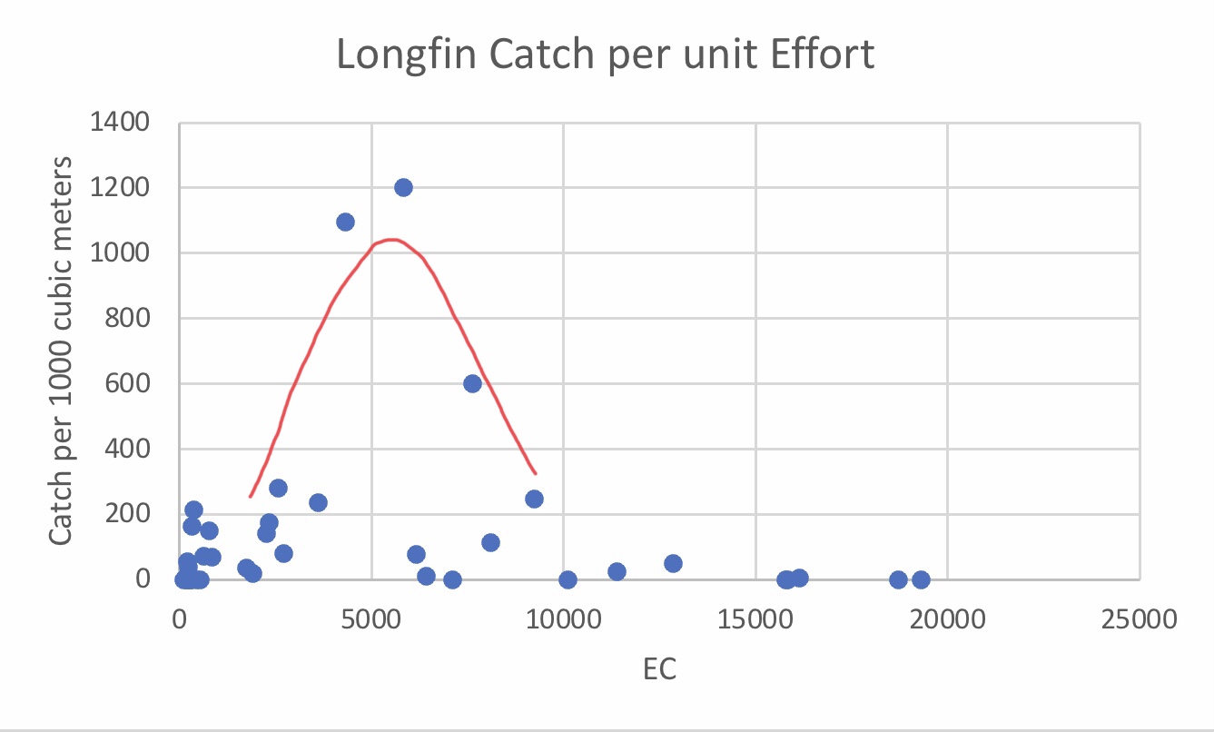
Larval longfin smelt were widely collected in the late February Smelt Larva Survey (Figure 2). Highest densities were in the low-salinity zone (Figures 2 and 3). Numbers were higher than in recent years, likely reflecting good early winter condition after high December Valley-wide precipitation.

These modest improvements in the endangered smelt populations will likely be short-lived as the State Board enacts the Temporary Urgency Change Petition (TUCP) of the Department of Water Resources and the Bureau of Reclamation in response to the winter 2022 drought. The TUCP will further reduce freshwater outflow and move the low-salinity zone upstream into the Delta (Figure 4 and 5). Depleted reservoir storage resulting from excessive storage releases to water contractors in 2020 and 2021 created the need for the petition. Despite the depleted reservoir storage, less extreme measures are possible that would provide some protection for the smelt, as discussed in an April 5 post.

Figure 1. Partial results of late March 2022 20-mm Survey, showing location of 5 identified Delta smelt larvae in Cache Slough Complex.

Figure 2. Results of late February 2022 Smelt Larva Survey, showing density of longfin smelt larvae collected in Bay-Delta survey region. Red outline is area of low-salinity zone (2000-8000 EC).

Figure 3. Plot of longfin smelt larvae catch per 1000 cubic meters sampled in late February Smelt Larva Survey (shown in Figure 2). Red curve shows that larvae were concentrated in the low-salinity zone (2000-8000 EC).

Figure 4. Salinity at confluence of Sacramento and San Joaquin Delta channels in eastern Suisun Bay in late winter – early spring 2022.

Figure 5. Calculated Delta outflow in late winter – early spring 2022.

A Simplified Look at the Complex World of Fish Population Dynamics

I have a simplified approach in analyzing fish population dynamics from which I review the status of populations of smelt and salmon. It looks at the dynamics of the relationship between the number of spawning adults and their returning adult recruits one to several years later (Figure 1). In the fish science vernacular, it is sometimes referred to as the “spawner-recruit curve” or “stock-recruitment relationship” or simply “S/R relationship”. The major features of a S/R relationship are shown in Figure 1 (A, B, and C):

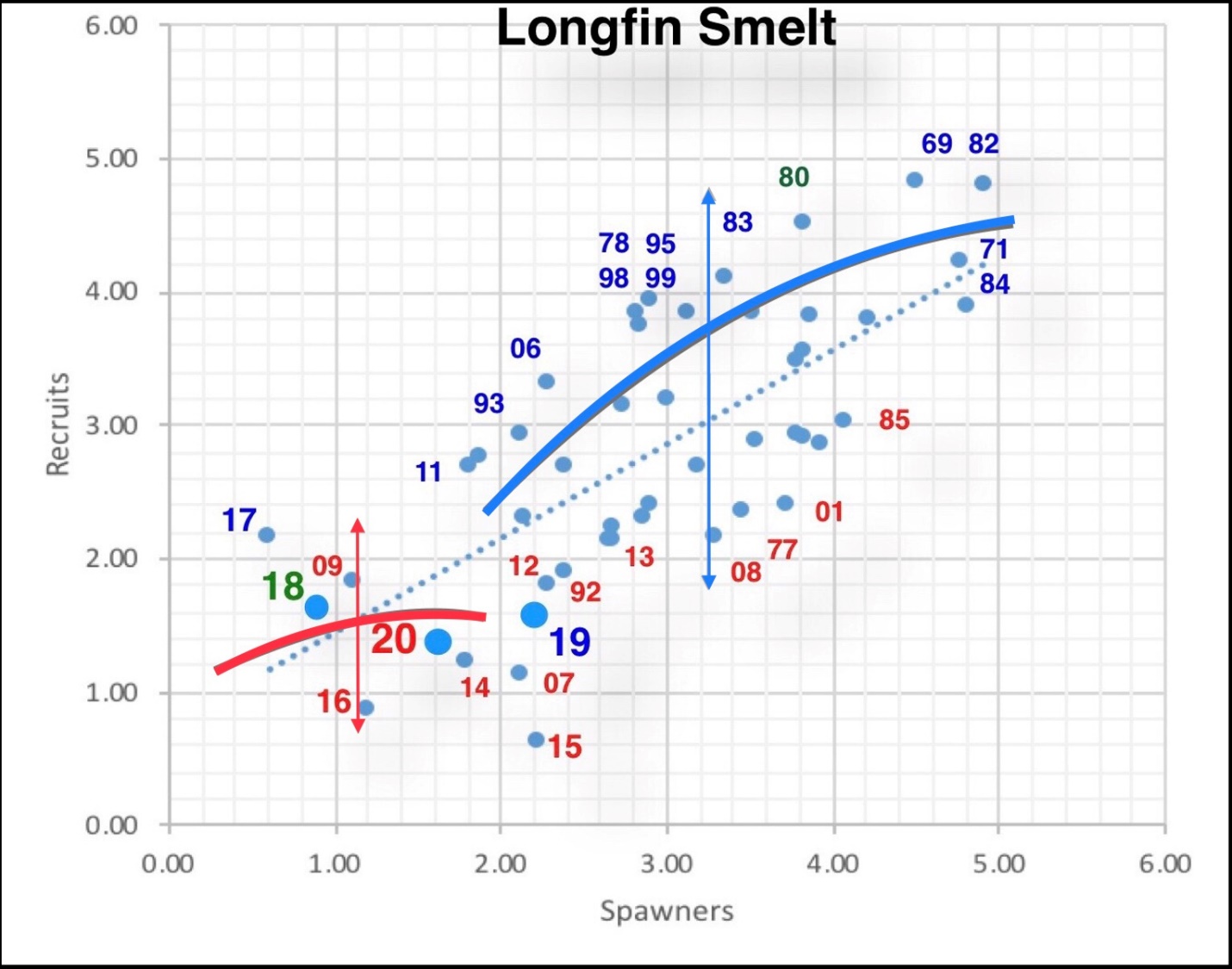
A. The blue and red curves show a standard spawner-recruit relationship, with higher spawners bringing more recruits – more eggs, more young, more smolts, more returning spawners, etc. It tails off when too many adults result in competition for food or spawning habitat, or higher rates of communicable disease – density-dependent effects.

B. The variability around the blue and red curves, shown by the vertical lines through the curves, is caused by density-independent effects such as drought, fishing harvest, or pollution that vary from year to year.

C. The difference between the blue and red curves, shown in the example as a yellow arrow, is a shift in the S/R curve that is a result in a fundamental shift in the relationship. Examples of such changes are the amount or quality of habitat from a dam being built, watershed destruction from a fire, loss of streamflow from new water diversions, loss of prey base, etc. The blue curve shows the S/R relationship before a fundamental shift; the red curve shows the S/R relationship after the fundamental shift.

Some environmental factors can affect one or more of the three features. For example, hatcheries can increase recruits (A and B), or they can cause a fundamental shift in the relationship (C) by imposing genetic changes in the population. Hatcheries benefit egg viability and fry survival, producing more smolts to the ocean per spawner in salmon populations, but may alter the wild component’s genetic viability.

The winter-run salmon population’s S/R relationship (Figure 2) exhibits these features, as well as the overall complexity in the relationship. Hatchery smolt introductions have propped up the population over the past two decades and increased its variability (red curve and vertical line), especially during periods of drought.

For longfin smelt, a state-listed species, there is a strong S/R relationship (Figure 3) to the features described in A-C above. There is a strong positive S/R relationship (A). There is a strong effect of the climate (B). And there appears to be a fundamental shift in recent years (C).

For Delta smelt (Figure 4), a state- and federally-listed species, which I consider nearly extinct at least in the wild, there was a strong S/R relationship (A), a climate effect (B), and a fundamental shift (C). The latter proved simply not sustainable, leading to a population crash that is not recoverable without supplementation (hatchery inputs) or drastic changes In environmental conditions.1 Note that 2016 is the last year in this figure, because the population since 2017 has been too close to zero to evaluate.

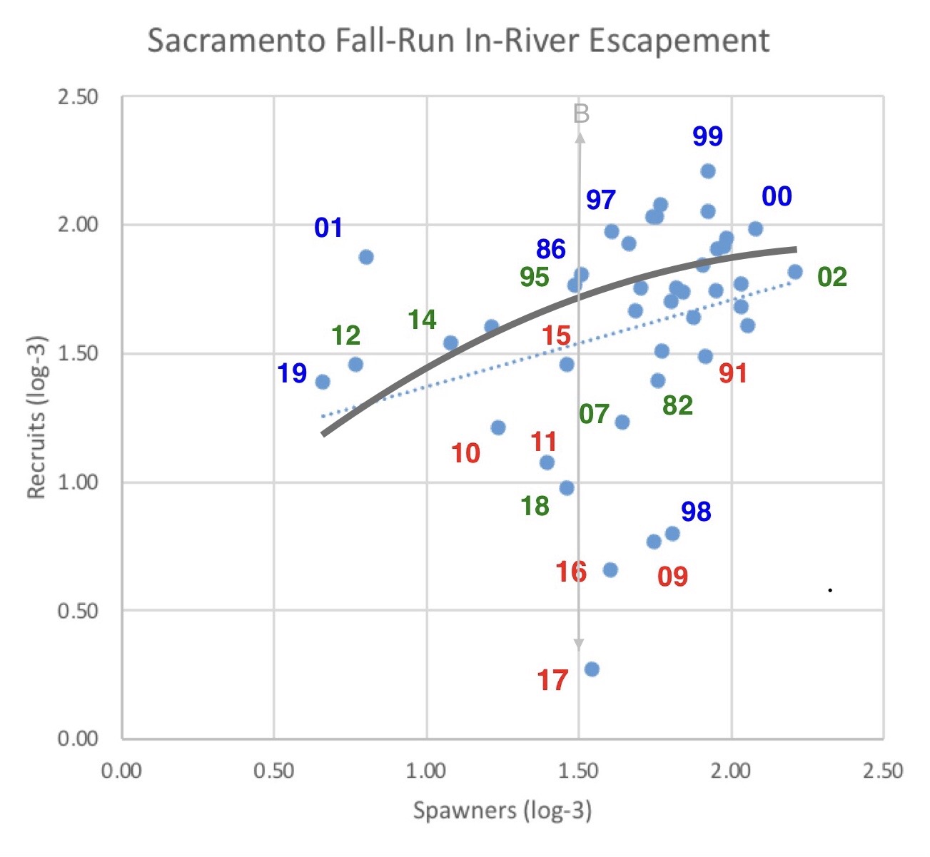
The largest salmon population, the Sacramento fall-run salmon, long sustained by hatchery inputs, is mainly controlled by feature B (Figure 5). Climate and water management are the dominant control of survival of hatchery and naturally-produced smolts reaching the ocean.

In conclusion, I recognize that S/R relationships represent a simplified view of extremely complex and changing relationships in the real world. Estimates of the number of spawners and recruits are often crude. But the relationships are real and statistically significant. It is up to us to interpret them by relating causal factors and developing hypotheses that can be tested with further scientific study and experiments. Unfortunately, managing fishery resources in the face of complex ecology, difficulty monitoring, natural variability, and statistical measurement errors is inherently difficult, even before political and economic factors get into the mix.

Figure 1. Spawner-Recruit relationships with three main features (A-C). See text for explanation of the features. In figures 2-4 below, the blue curve represents the historical S/R relationship. The red curve represents the new historical S/R relationship following a fundamental shift in the relationship, including long-term drought. The vertical lines through the curves show the range of the annual variability of the S/R relationship attached to each curve, excluding the density-dependent variability that is incorporated into the curve. In this example figure, the yellow curve tracks a fundamental shift in the S/R relationship. Spawners are shown on the x-axis; recruits are shown on the y-axis. The numbers on the axes are log transformed in order to make size of the figures manageable; log transformation does not alter the statistical relationships.

Figure 2. Spawner-Recruit relationship for winter-run Chinook salmon in the Sacramento River. Numbers shown represent the brood year of recruits (number of returning adults) for year displayed. For example, “11” represents fish produced in wet year 2011. The color of the number shows the conditions when brood was spawned and reared in the upper Sacramento River below Shasta Dam before emigrating to the ocean. A red number shows a dry year during spawning and early rearing. A blue number designates wet year spawning and rearing conditions. A green number designates normal water year conditions. For example, 15 represents brood-year 2015 recruits that returned in 2018, while its red color designates drought conditions in 2015. In this figure, numbers on axes are log-2 transformed.

Figure 3. The longfin smelt S/R relationship. The number and color represents the brood year’s fall index (recruits) and its water year type during its spawning run and first year of rearing. The spawners are the index from two years earlier. For example, the red number 15 represents the fall index for brood-year 2015 under water-year 2015 drought conditions, with spawners being the recruits from 2013. In this figure, numbers on axes are log-log transformed.

Figure 4. The Delta Smelt S/R relationship. I added two curves and a vertical line to an original figure to show the hypothesized S/R relationship; there is too little variability in the red curve for a vertical line to be meaningful.

Figure 5. Spawner-Recruit relationship for upper Sacramento River mainstem fall-run Chinook salmon. Number is recruitment year (escapement). Spawners are recruits from three years prior. Numbers are log minus 3 transformed. A red number shows a dry water year two years prior during rearing and emigration. A blue number shows a wet year two years prior. A green number shows for a normal water year two years prior. For example: red 17 represents 2017 run that reared in drought year 2015, with spawners (parents) being the 2014 green run number. Note that only one curve is shown. in gray, for this run of salmon, which is almost entirely dependent on hatchery production.

Water Projects’ Temporary Urgent Change Petition 3/18/22 Comment on Provision #1 – Spring (April-June) Delta Outflow and Salinity Intrusion

The U.S. Bureau of Reclamation and the California Department of Water Resources (Reclamation and DWR) filed a “Temporary Urgency Change Petition” (TUCP) on March 18, 2020.  If granted, the TUCP reduce Delta outflow requirements.  The proposed averaging requirements in the TUCP pose a problem in addition to the problem of too little overall outflow.

The TUCP states:

Reclamation and DWR are requesting to modify certain terms as the Projects’ storage and inflow may not be sufficient to meet D-1641 requirements and additional operational flexibility of the Projects is needed to support Reclamation and DWR’s priorities, which include: operating the Projects to provide for minimum health and safety supplies (defined as minimum demands of water contractors for domestic supply, fire protection, or sanitation during the year); preserve upstream storage for release later in the summer to control saltwater intrusion into the Sacramento-San Joaquin Delta (Delta); preserve cold water in Shasta Lake and other reservoirs to manage river temperatures for various runs of Chinook salmon and steelhead; maintain protections for State and federally endangered and threatened species and other fish and wildlife resources; and meet other critical water supply needs. (3/18/22 TUCP, p. 1)

The TUCP is requesting reduced Delta outflow requirements for the April 1 through June 30, 2022 period, for the stated primary purpose of preserving storage in Oroville and Folsom reservoirs.   What I term Provision #1 is reduction of outflow requirement from 3-day average of 7,6001 to 14-day average of 4,000 cubic feet per second (cfs).

The requirement in Revised Water Rights Decision 1641 of a 3-day average of 7,600 cfs is meant to keep salt water from encroaching upstream from the Bay into the Delta in drought years like 2021 and 2022.   This helps to protect the beneficial uses in the Delta including fish, fish low-salinity habitat, Delta agriculture, and south Delta water export water quality.  The TUCP’s proposed Delta outflow of 4000 cfs is meant to provide minimum protection in the face of low available water supply (reservoir storage and precipitation).

The overriding problem with the TUCP’s proposed flow reduction is that it does not require enough flow.  Yet, even accepting the need to reduce flow to allow storage of more water in Reclamation and DWR’s reservoirs, the requested change could be modified to better protect beneficial uses.

Under past TUCPs, DWR and Reclamation have used the 14-day averaging window to game operations to skate as closely as possible to the edge of compliance.  This has led to erratic outflows, often below 4000 cfs (Figure 1).  More precise estimates taking into account tides show outflow is lower than intended (Figure 2).  In these circumstances, salinity has increasingly moved up from the Bay into the Delta under such minimum freshwater outflow (Figures 3-6).

I recommend the outflow required be more stable, allowing for only minimal salinity increase over the spring.  A 3-day average of 4,000 cfs measured outflow would provide greater protection of beneficial uses.

Salinity criteria are more easily defined and measured, and more directly related to beneficial uses.  Criteria for Collinsville, Emmaton, Jersey Point, and Old River that have a maximum for a 3-day average or a maximum daily level with a minimum increase over the spring would also be more protective.

Figure 1. Daily Delta outflow estimated from measured Delta hydrology conditions in spring 2014, 2015, and 2021, drought years when previous TUCPs were implemented

Figure 2. Measured Delta outflow into Suisun Bay in spring 2021.

Figure 3. Salinity in eastern Suisun Bay in spring 2021.

igure 4. Salinity in lower end of Sacramento River near Rio Vista in late April 2021.

Figure 5. Salinity and net tidal flow in lower San Joaquin River channel at Jersey Point in spring 2021.

Figure 6. Salinity (EC) and net tidal flow in lower Old River channel in south Delta near Byron in spring 2021.

  1. The normal requirements are stated in Revised Water Rights Decision 1641, Table 3, footnote 10, pp. 185-186.  The April-June requirement in a Critically Dry year is also met if either the daily average or 14-day running average EC (measurement of salinity) at the confluence of the Sacramento and the San Joaquin rivers is less than or equal to 2.64 mmhos/cm (Collinsville station C2).  From May 1 through June 30, if the Sacramento River Index is less than 8.1 million acre-feet, the flows requested in the TUCP would be the same as the required flows under Decision 1641.