WINTER-RUN CHINOOK SALMON A Plan for the Future

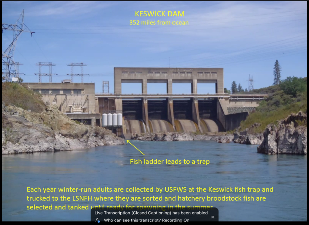
Photo 1. Keswick Dam – the upper extent of salmon in the Sacramento River. Source: USFWS

Winter-run Chinook salmon were once found throughout the Upper Sacramento River watershed, including the Sacramento, McCloud, and Pit River drainages, as well as in Battle Creek (Figure 1).  Following the construction of the Central Valley Project’s Shasta and Keswick dams in the 1940s, winter-run were confined to the lower Sacramento River below Keswick Dam.

Winter-run are one of four Chinook salmon subspecies found in the Central Valley.  As “winter-run,” the historical population took advantage of the Mediterranean climate’s wet winter and spring to migrate to and from the ocean to optimal spawning habitats in the Mount Shasta and Mount Lassen volcanic Cascade watersheds.

Adults returned from the ocean in winter and spring, reaching elevations near 3,000 feet on the west and south flanks of Mount Shasta in the upper Sacramento River, McCloud River, and Pit River.  Cold, clear spring waters sustained them until they spawned in late spring and summer.  Fry emerged from the gravel redds in early fall.  High winter-spring flows transported fry to the Lower Sacramento River, Valley floodplains and the Bay-Delta estuary that provided optimal winter rearing conditions (e.g., water temperatures from 10-15oC), with abundant food and cover in marshes, creeks, and sloughs.  The fry grew to ocean-ready smolt size by late winter and early spring and headed to the ocean.

The system was ideal, producing hundreds of thousands if not millions of adult winter-run salmon which many native peoples depended on for centuries.

But that all changed in the mid-20th Century when winter-run salmon populations were decimated by dams that blocked adult salmon access to their historical spawning grounds.  Winter-run salmon persisted in the Sacramento Valley below Shasta and Keswick dams in tailwater habitat sustained by cold-water releases from the depths of Shasta Lake, a modicum of spawning and rearing habitat, and – since 1998 – by one conservation hatchery. Much of the remaining spawning, rearing, and migration habitats were lost to mining, water diversions, roads, logging, and urbanization.

Winter-run salmon were nearly gone from the Sacramento River after the 1976-77 drought.  Cold-water habitat was not sustained below Shasta Dam in the drought, and escapement plummeted (Figure 2).  The escapement (returns) in 1979 and 1980 from brood years 1976 and 1977 was very low.  Brood year 1978, the offspring of brood year 1975 (which had been in the ocean during the drought) did well in wet year 1978 and returned well in 1981.  However, because of dry conditions in 1981, survival of brood year 1981 was poor.  The failures of brood years 1976, 1977, and 1981 (and their offspring) led to a general population collapse.

The subsequent 1987-92 drought led to the near extinction of the run and its listing as endangered under the federal and state endangered species acts.  Protections mandated in the listings, a decade of wetter years (1993-2003), some major improvement in CVP infrastructure and operation, and initial operation of the Livingston Stone Winter Run Conservation Hatchery in 1998 led to a partial recovery from 2001-2006.

The population declined again with the 2007-2009 and 2013-2015 droughts, with only partial recovery after two wetter periods (2010-2012 and 2016-2019).

The 2020-2022 drought caused poor brood year 2020 and 2021 fry production (Figure 3) and subsequent poor escapement in 2023 and 2024 (see Figure 2).  Emergency management actions in 2022, including the establishment of a new Battle Creek population and increased hatchery production, may have helped ameliorate some of the effects of the 2021-22 drought, leading to an increase in the 2025 returns (based on initial indications).  Despite its low fry numbers, brood year 2022 had good juvenile survival conditions in wet winter 2023 and good conditions for returning adults in above-normal water year 2025.  Also, closed fisheries from 2023-2025 contributed to strong 2025 escapement.  The good 2025 run and the good habitat conditions in 2025 resulted in strong fry production of brood year 2025 (Figure 3).

Many factors contributed to these long-term population trends, including negative factors such as overfishing, degradation and loss of freshwater and estuarine habitat, Shasta-Trinity hydropower operations, poor ocean conditions, disease, and hatchery practices.1 These include:

  • Overfishing – Though winter-run adults in the ocean are partially protected with closure of spring coastal fisheries near the entrance of San Francisco Bay, winter-run immature adults are not explicitly protected in other seasonal fisheries during their two-year period of ocean residence. Regional closures in ocean fisheries based on known ocean movements of winter-run are only partially effective.
  • Fall-winter rearing and out-migration habitat – Fall-winter habitat in the 200 miles of river and Delta habitat between Redding and the Bay are essential for winter-run brood year survival and smolt production to the ocean. Especially important are late fall and early winter movement to and through the Delta that are stimulated by stream flows and sustained by the first river flow pulse.2  Operation of the Delta’s Cross Channel gates and south Delta diversions restrictions play a very large role in successful outmigration (Figure 4).
  • Hydropower Operations – Shasta-Trinity Division hydropower operations affect real-time stream flows and water temperatures in the lower Sacramento River in the summer, fall, and winter seasons. Late-fall reductions in Keswick Dam releases at the end of the irrigation season limit both spawning and incubation habitat and flow-related downstream migration.
  • Poor Ocean Conditions – Poor Ocean conditions in 2007-2009 that contributed to the 2008-2009 crash of fall-run salmon also likely contributed to poor winter-run escapement.
  • Hatchery Practices – Hatchery practices for the most part have been beneficial to the winter-run population through the release of several hundred thousand sub-yearling smolts per year. However, releases near the hatchery in drier years help minimally because fewer hatchery smolts survive to the ocean.  Survival of coded-wire tagged winter-run hatchery smolts in dry years (Table 1) is only about 1/10th of that in wet 3  Survival is improved when hatchery smolt releases are coordinated with natural or prescribed pulse flows.4

Recommended Actions

Recovery recommendations are outlined in this section in three categories: habitat, hatcheries, and harvest.  The two main themes of the recommendations are (1) the best strategies for dealing with warmer, drier years and (2) improving population recovery after droughts.  These themes will require policy improvements for both drought and non-drought years.  The recommendations can be reasonably implemented based on the historical range and capabilities of winter-run salmon, but they may prove difficult under present political and social demands for water supply and project operations (e.g., hydropower peaking demands).

Lower Sacramento River – water temperature:  Maintain spring water temperatures in the Lower Sacramento River downstream from Red Bluff to the Delta (Freeport gage) at <65oF.  At all other times water temperature should be no higher than 68oF from Red Bluff to the Delta.

Upper Sacramento River – water temperature:  Maintain water temperatures at or below a maximum of 53oF in the Upper Sacramento River below Keswick Dam (river mile or RM 300) downstream to the mouth of Clear Creek (RM 290), and at or below a maximum of 56oF below the mouth of Clear Creek to the mouth of Battle Creek, and at or below 60oF from the mouth of Battle Creek to Red Bluff (RM 240).  (See Figure 5 for suggested standard/objective.)

Upper Sacramento River – streamflow:  Adaptively manage stream flow in the 6,000-10,000 cfs range depending on available cold-water pool supply and irrigation needs, fall-run salmon spawning, and the need to ensure that a late summer/fall stage drop does not lead to redd stranding for winter-run or fall-run salmon.  I recommend, at minimum, two pulse flows, each of 10,000 cfs minimum at Red Bluff, supported as needed by Keswick Dam releases, one in late fall or early winter coinciding with the first seasonal rains, and one around early February.

Sacramento River Base Winter Flow:  For the Sacramento River through the Delta, I recommend a base minimum flow of at least 5,000 cfs to maintain juvenile salmon transport and rearing habitat.

DeltaThe Delta Cross Channel (DCC) should be closed during fall flow pulses.  South Delta exports should be kept to a minimum during fall flow pulse.  Sacramento River Delta inflow (Freeport gage) should have a minimum daily (tidal) average flow of 20,000 cfs in late fall and winter.  Delta outflow should have a minimum daily (tidal) average flow of at least 10,000 cfs in late fall and winter.

Hatchery:  Release winter-run hatchery smolts to the Sacramento River and Battle Creek near Redding during flow pulses.

Hatchery:  Raise hatchery fry in controlled Lower Sacramento River floodplain habitats for volitional release during flow pulses.

Above Shasta Reservoir Trap-and-Haul:  More fully develop the trap-and-haul program to establish winter-run salmon subpopulations in (1) the spring-fed reach of the upper McCloud River above McCloud Falls, where stable water temperatures and stream flows are best for the logistical requirements of such a program; and (2) Ripley Creek, the South Fork Battle Creek tributary historically fed by Hazen Spring.  Offspring from such efforts can be readily trapped from these controlled flow spring creeks and returned to the hatchery for further rearing or release.

Fishery Harvest: Mark-selective fishery harvest rules could limit harvest of natural-born winter-run salmon.  Incidental catch (bycatch mortality) should be minimized in fishery areas frequented by adult immature and mature winter-run salmon through fishery restrictions.  Mark-selective harvest would involve large-scale investment in more complete hatchery marking throughout the Central Valley hatchery system, most of which currently marks only one quarter of hatchery production.


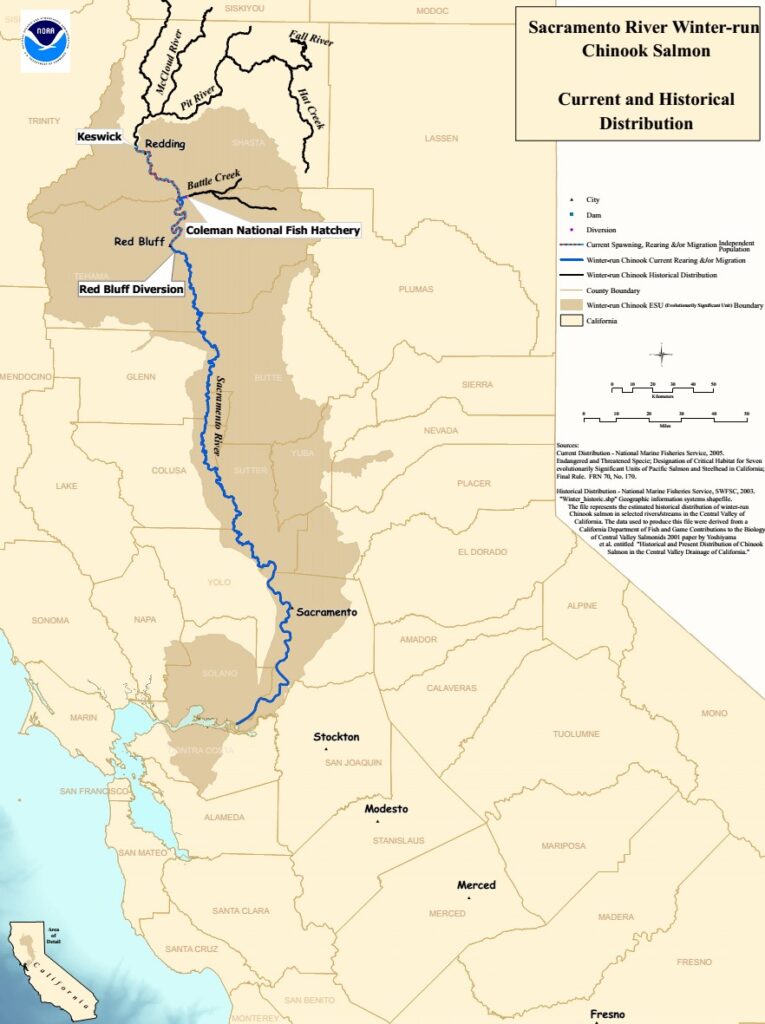
Figure 1. Winter-Run Chinook salmon Streams of the Central Valley. Source: NMFS.

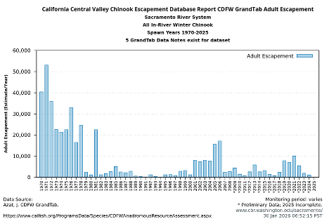
Figure 2. Winter-run Chinook salmon escapement in the Sacramento River mainstem, 1970 to 2024. Note: Winter-run escapement is made up of the total of these components: (a) Winter in-river Battle Creek – upstream of CNFH: Fish passed upstream of Coleman Weir; (b) Winter in-river Clear Creek: not a stable breeding population; (c) Winter in-river mainstem Sacramento – downstream of Red Bluff Diversion Dam (RBDD): downstream mainstem numbers based on upstream estimates and redd distribution; (d) Winter in-river mainstem Sacramento – upstream of RBDD: upstream mainstem in-river estimates prior to 2001 were based on RBDD counts. Subsequent estimates are based on carcass surveys. Numbers using RBDD data are adjusted for angler harvest.

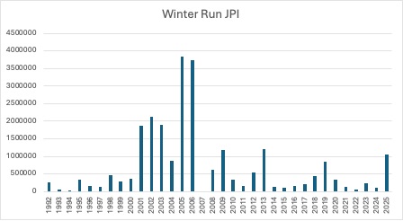
Figure 3. Winter-run juvenile production index (JPI) from Red Bluff trap collections 1992-2025. Data source: USFWS Red Bluff.

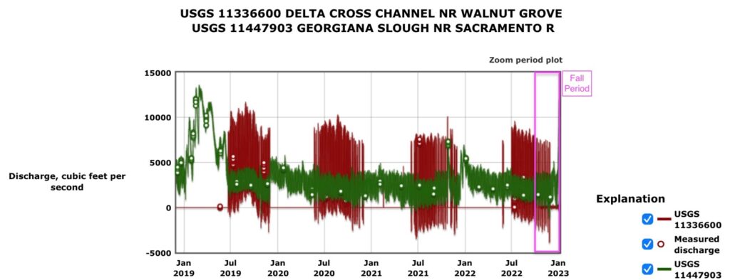
Figure 4. Hourly streamflow in the Delta Cross Channel and Georgiana Slough in the northern Delta, 2019-2022. Note that zero discharge at the Delta Cross Channel gage indicates the gates were closed.

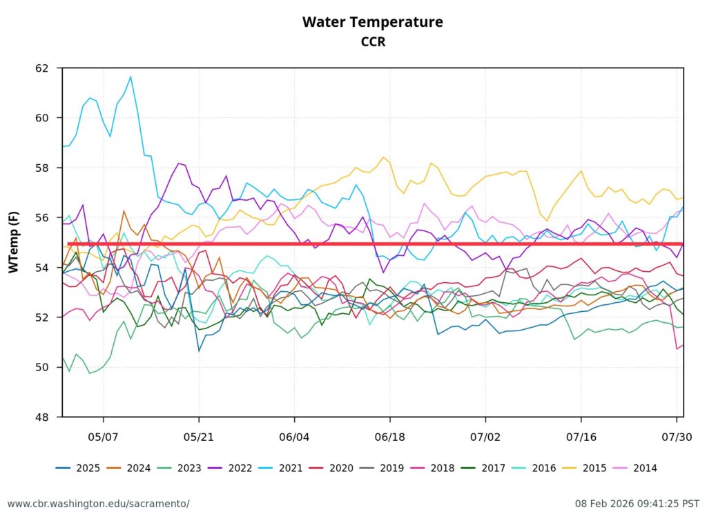
Figure 5. Hourly water temperature in the upper Sacramento River above the mouth of Clear Creek (rm 290) in the May-July spawning season of winter-run salmon. Red line is the upper end of safe spawning water temperature for salmon.

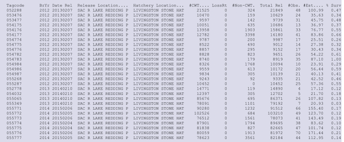
Table 1. Tag returns for winter-run hatchery smolt release groups for brood year 2012-2014, with date released, release location, and estimated percent survival (escapement plus fishery catch). Note there were significantly higher survival rates for brood year 2012 (2013 release date) than brood years 2013 and 2014.

  1. (NMFS), West Coast Region (WCR). 2016. Viability Assessment for Pacific Salmon and Steelhead Listed under the Endangered Species Act: Southwest. Dated: February 2, 2016. Southwest Fisheries Science Center (SWFSC), Fisheries Ecology Division, 110 Shaffer Road, Santa Cruz, CA 95060.
  2. https://calsport.org/fisheriesblog/?p=4034, https://calsport.org/fisheriesblog/?s=winter+run+salmon&submit=Search&paged=3
  3. https://calsport.org/fisheriesblog/?p=4096
  4. https://www.fisheries.noaa.gov/feature-story/sacramento-river-pulse-flow-expected-increase-survival-juvenile-salmon-traveling-ocean

Delta Smelt Summer 2024 – ONE IS THE LONELIEST NUMBER

A weekly survey by the US Fish and Wildlife Service1 targeting Delta smelt captured one Delta smelt in early August 2024 (Figure 1). It was the first and only Delta smelt caught this summer in that smelt-targeted survey in the Bay-Delta Estuary. A late April IEP juvenile fish survey (the 20-mm Survey) caught several juvenile Delta smelt in the same area (Figure 2).

What is unique about this location in Suisun Bay? In 2024 the low-salinity-zone (LSZ) has been located in Suisun Bay for most of the spring and summer, as Delta outflows have been maintained at 8,000-12,000 cfs (Figure 3). The LSZ is the critical spring-summer habitat of the Delta smelt (a salinity range related to high survival in the population). When the LSZ is in Suisun Bay, it generally remains within the maximum temperature tolerance of Delta smelt (70-72oF). When Delta outflow falls below about 7,000-8,000 cfs, the LSZ moves east into the warmer Delta. Delta water quality standards (D-1641) require a minimum outflow of 7,000 cfs in wetter years for this reason. When it is east in the Delta, the LSZ tends to have warmer water due to higher air temperatures. The Delta smelt biological opinions have a provision called “Fall X2” that requires extra Delta outflow in late summer to help ensure Delta smelt are west in Suisun Bay (Figure 4), where they have higher survival potential.

The LSZ does not occupy a large area – it is generally a small mixing zone where fresher water meets the saltier water. The LSZ moves up and down the estuary with the monthly and daily tidal cycles. The one smelt was caught in early August, when the LSZ happened to be at that net sampling location (Figure 5) because of the relatively high Delta outflows in summer of above-normal water year 2024. In contrast, much lower Delta outflows in summer of drought year 2022 brought saltier water to Suisun Bay (Figure 6), and the LSZ was upstream in the warmer lower Sacramento River channel of the Delta near Rio Vista (Figure 7).

In closing, there are a few Delta smelt left – but it is near the end of over five decades of population decline that has brought them single digits away from extinction (Figure 8). The cause in large part has been the devasting effects of low spring-summer Delta outflows in drier years that maintained the LSZ upstream of the Bay in the warmer Delta, where the smelt cannot survive. Efforts to protect the smelt in only in wetter years by requiring higher Delta outflows were positive, but requirements in wetter years alone are not enough: the smelt only live one year. The only option left is to maintain the 10,000-12,000 cfs Delta outflow in all years, raise the captured brood stock at UC Davis for release in the LSZ in the Bay, and hope the species can recover. The cost would be about 1 million acre-feet of water supply in the drier years over the summer.

The choice was made for us by DWR and in the soon-to-be-released US Fish and Wildlife Service updated biological opinion on the long-term effects of the state and federal water projects. The most recent opinion issued in 2019 stated the projects do not jeopardize the viability of the Delta smelt population. Now we seem intent on removing the one remaining lonely smelt. Just remember, the Delta smelt were supposed to be the “canary in the coal mine.”

Figure 1.  The EDSM week-6 2024 survey results for Delta smelt.  Note one smelt was captured in western Suisun Bay.
Figure 2.  The catch distribution of Delta smelt in Survey 4 2024 of the 20-mm survey. 
Figure 3.  Delta outflow in summer 2024.
Figure 4.  Delta outflow in summer 2007-2024.  Note above-normal water year 2024 had consistent summer flows of 8,000-12,000 cfs.  Note wet years 2011, 2017, 2019, and 2023 had Fall X2, but 2024 has not.
Figure 5.  Salinity (ppt) and water temperature (F) in western Suisun Bay in summer of above-normal water year 2024.
Figure 6.  Salinity (ppt) and water temperature (F) in western Suisun Bay in summer of drought year 2022.
Figure 7.  Salinity (ppt) and water temperature (F) in lower Sacramento River channel of western Delta in summer of drought year 2022.
Figure 8.  Relationship (log-log) of the fall index to the prior summer index for Delta Smelt.  Dry year production (red years) generally is an order of magnitude lower than wet (blue) and normal (green) water years from summer to fall (A vs C-D).  The population declined based on both indices by over 99% from the 1970’s to the mid-2010’s.  Note 1990 and 1991 had relatively high summer and fall indices because South Delta export rates were very low in the fourth and fifth years of drought because reservoir water storage was minimal.  Note 2014 and 2015 had lower than expected fall indices under summer TUCP outflows.  Water year 2017 (bold #17) was the initial year of the virtual extinction period for Delta Smelt observed in the Fall Midwater Trawl Survey.

  1. Enhanced Delta Smelt Monitoring, 2024 Phase 3 Preliminary Analysis, U.S. Fish and Wildlife Service, August 30, 2024 DRAFT

Klamath River Update – September 2024

In an August 1, 2024 post, I updated the status of water quality in the Klamath River during the 4-dam removal project. I had several concerns: sporadic turbidity events, dropping flow rates, and higher water temperatures; all of these concerns had been acknowledged in the project’s planning documents.

Final steps to remove dams on the Klamath River in summer 2024, including dumping additional sediment from exposed reservoir reaches, has again raised concerns about water quality in the Klamath River. The problem is that, this time, fall-run Chinook salmon runs to tributary streams like the Scott and Shasta Rivers are at their peaks. Such water quality degradation events, especially during the late summer fall-run Chinook migration season, would normally be considered violations of state and federal water quality standards. However, these events were expected in the monumental 4-dam removal project on the lower Klamath River.1

Excerpts from NMFS biological opinion (p. 164 of NOAA 2021):

“Effects associated with reservoir drawdown (i.e., SSC and dissolved oxygen impacts) will affect all populations of SONCC coho salmon that utilize the Klamath River during some portion of their life history cycle, while the other short-term effects associated with dam removal, construction, and restoration will primarily be limited to individuals from the Upper Klamath population. Therefore, the proposed action is likely to adversely affect coho salmon from the Upper Klamath River, Shasta River, Scott River, Middle Klamath River, Salmon River, Lower Klamath River, Upper Trinity River, Lower Trinity River, and South Fork Trinity River population units in the short term.”

“Behavioral effects resulting from elevated suspended sediment include alarm reactions, avoidance, and reduced feeding. Cederholm and Reid (1987) found that juvenile coho salmon prefer low to medium concentrations of suspended sediment, and that juvenile coho salmon prey capture success significantly declined at concentrations of 100 to 400 mg/l. Salmonids have been observed to prefer clear over turbid water (Bisson and Bilby 1982), and move vertically near the water surface (Servizi and Martens 1992) and/or downstream to avoid turbid areas (McLeay et al. 1984; McLeay et al. 1987). More than six weeks of exposure to concentrations of 100 mg/L reduces feeding success, reduces growth, causes avoidance, and displaces individuals (Spence et al. 1996).”

“Suspended sediment contributes to turbidity, which also can have adverse effects if excessive. Bisson and Bilby (1982) found that juvenile coho salmon avoided water with turbidities of 70 Nephelometric Turbidity Units (NTU).”

The problem this summer has been the removal of coffer dams, other remaining infrastructure, and further remaining reservoir sediments (Figure 1). The release of oxygen-demanding sediment caused critically low dissolved oxygen levels for several days in late August, from the Iron Gate gage (Figure 2) downstream 30 miles to the mouth of Walker Creek (Figure 3, about midway between the mouths of the Scott and Shasta Rivers). Highly stressful levels of suspended sediment (>300 FTUs) occurred for nearly a week, and also occurred sporadically through September, downstream as far as Orleans (Figure 4). With water temperatures in the river falling through September (Figure 5), the annual run of adult fall-run Chinook salmon was likely occurring (Figure 6).

The risks to coho salmon and juvenile salmon were likely minimal in summer. The coho salmon run occurs in November-December. Juvenile coho and Chinook salmon juveniles begin moving out of the tributaries with the first significant fall or winter rains. The rains will also bring erosion of accumulated sediment that could cause stress and mortality this winter and spring, factors that were also anticipated in project planning/permitting documents.

Figure 1.  Iron Gate gage turbidity recordings 8/22/24 to 9/22/24.
Figure 2.  Iron Gate gage dissolved oxygen measurements in 2024.  Note zero levels recorded during initial dam breaching in late January and Iron Gate cofferdam removal on August 28.
Figure 3,  Dissolved oxygen recordings in Klamath River in summer 2024.
Figure 4.  Turbidity recordings in Klamath River in summer 2024.
Figure 5.  Water temperatures in Klamath River May-September 2024.
Figure 6.  Fall-run Chinook timing to lower Shasta River in 2016.

From KRRC Facebook pages September 2024:

“The breaching of the cofferdam at Iron Gate released fine sediment – predominantly dead algae – from the former reservoir footprint. As this sediment has moved downstream, there have been impacts to water quality in the reaches below Iron Gate. The largest of these impacts has been increased turbidity levels and large reductions in dissolved oxygen concentrations immediately downstream of the Iron Gate dam site. For decades there have been enormous seasonal blooms of toxic blue green algae in the reservoirs behind the Iron Gate, Copco No. 1, and J.C. Boyle dams and millions of cubic yards dead algae settled to the bottom over years. While most of this dead organic matter was flushed downstream during the drawdown when the reservoirs were drained back in January, some remained on the backside of the Iron Gate cofferdam. That sediment was released earlier this week when the river was returned to a free-flowing state with the breaking of the cofferdam.

“As this oxygen starved dead organic matter is flushed out from the former reservoir into the river, it absorbs the oxygen in the water. That leads to a drop in available oxygen for aquatic animals in the river, including fish.

“KRRC continues to monitor the impacts of this pulse of sediment. The intensity of the impacts to water quality has been decreasing as the turbid water moves downstream. The dips in dissolved oxygen have been smaller and shorter in the downstream reaches of the river, as freshwater from tributaries dilutes the sediment in the river.

“Crews monitoring the situation have observed some mortality among fish in the river reach directly below Iron Gate Dam. These impacts are unfortunate but expected following such a drop in dissolved oxygen. Fortunately, we have not seen mortality in returning adult salmon, currently making their way upstream. Crews will continue to monitor the situation, and we will share information as we learn more.

“This is precisely the kind of temporary negative impact that was anticipated and fully analyzed by state and federal regulatory agencies overseeing the dam removal. Scientists and other experts determined that any short-term pain associated with the dam removal activity was worth the long-term gain for the health of the river, native fish species, and surrounding communities. After the Iron Gate cofferdam was broken last week, some parts of the cofferdam remained in place to allow for the removal of diversion infrastructure. KRRC will remove this remaining piece of in-river infrastructure before the project is completed later this month. Following the breach, a significant amount of impounded sediment began to move down-river, but some remains on the backside of the cofferdam segment still in place.

“Taking guidance from the project’s Fisheries Coordination Team, which is comprised of NOAA Fisheries, Karuk Tribe, Yurok Tribe, California Department of Fish and Wildlife, US Geological Service, US Fish & Wildlife Service and other fisheries and water quality specialists, KRRC will implement an assisted sediment evacuation plan in the coming days. Utilizing a long arm excavator to stir up the material, much of the remaining accumulated sediments will be sent downstream slowly in the coming weeks, ahead of the final removal of the what’s left of the Iron Gate cofferdam later this month. The goal of this activity is to remove as much of this material as possible gradually to limit water quality impacts later in the month, when adult salmon will be coming through the river reach directly below Iron Gate. While we have seen adult salmon already entering the river, they are currently downstream of the areas that were most affected by the sediment that has been released with the breaching of the Iron Gate cofferdam.

“The sediment, mostly consisting of dead algae, is non-toxic, and is too water-logged to effectively be removed from the river using machinery, so a gradual release was determined to be the best option to protect incoming salmon. As the sediment is gradually released downstream over the coming weeks, KRRC, Tribes, and public agencies will carefully monitor river conditions to ensure the dissolved oxygen levels are kept at habitable conditions for fish. Because the Klamath is, in general, a sediment-heavy system, it is important to note that Klamath River salmon are adapted to survive with a certain degree of sediment in the river as they migrate upriver to spawn.

Communities down river can expect turbid (murky) conditions to continue for the coming weeks. These conditions are temporary, and this controlled sediment removal is an important activity to protect the salmon currently making their way upstream.
You can see the targeted sediments for removal below. They are darker in color than the dam material and are upstream of the cofferdam on the right hand side of the image.”

Comments on Fall X2

I fully support implementation in 2024 of the Fall X2 action prescribed in the biological opinion for Delta smelt.  Furthermore, I support maintaining Delta Outflow at 10,000-12,000 cfs year-round[1] in all water year types to protect Delta smelt and longfin smelt.  The compelling reason for such action is to maintain the low salinity zone (LSZ) and the head of that zone downstream of the confluence of the Sacramento and San Joaquin rivers in the western Delta, on an average-daily or tidally-filtered basis (Figures 1 and 2). 

Such action will require approximately 10,000-12,000 cfs daily average Delta outflow (Figure 3).  Such action would ensure the LSZ is maintained downstream of the Delta within Suisun Bay, Suisun Marsh, and Montezuma Slough – conditions necessary to protect listed Delta and longfin smelt populations.  Otherwise allowing the LSZ to enter the Delta subjects the pre-spawn staging of the smelts (Figures 4 and 5) to entrainment into Delta water exports and the vagaries of Delta habitat (poor water quality and food supply, as well as lower turbidity and higher predation).  Failure to maintain the X2 in Suisun Bay below the confluence also undermines the integrity of the LSZ critical habitat of the smelt in future months.  My conclusions are further amplified in prior comments in support of the Fall X2 (https://calsport.org/fisheriesblog/?p=2940).

In conclusion, failure to implement Fall X2 will have an adverse impact on Delta smelt and longfin smelt and their critical LSZ habitat.

Figure 1.  Water temperature and salinity of eastern Suisun Bay near Pittsburg June-September 2024.

Figure 2.  .  Hourly and tidally filtered salinity of eastern Suisun Bay near Collinsville August-September 2024.  Note X2 is approximately 2 psu (ppt)

Figure 3.  Daily Delta outflow August-October in 2023, 2024, and average 2014-2023.  Note application of Fall X2 in September 2023 (> 8,000 cfs).

Figure 4.  October 2023 fall midwater trawl survey catch of longfin smelt.

Figure 5.  October 2011 fall midwater trawl survey catch of Delta smelt.


[1] Except in critical drought years when exports are minimum due to minimum available water supply.

White Sturgeon Recruitment to San Francisco Bay-Estuary in 2024

In a June 2024 post, I hypothesized factors controlling the white sturgeon population in San Francisco Bay-Estuary.  I concluded the major factor controlling the adult stock size was periodic recruitment of juvenile sturgeon from successful spring spawning and early rearing in the lower Sacramento River.  Successful recruitment only occurs in the wettest years, when there are higher streamflows and cooler water temperatures.

Recruitment of young white sturgeon in significant numbers has only occurred in three years since 2010:  2011, 2017, and 2023.  Recruitment in 2024, an above normal water year, is likely to be poor.  Production of young sturgeon is likely of function of attraction of spawners from San Francisco Bay (to high winter-spring river flows – good in 2024), good spawning conditions (streamflow and water temperatures – good in 2024), and good early rearing and transport conditions in the lower Sacramento River and the north and central Delta (streamflow and water temperatures – poor in 2024). 

The adult spawning stock size may not be as important as spawning conditions, given strong recruitment in wet year 2023 under a very low stock abundance (observed Bay die-off in summer of critical drought year 2022).

There are a number of measures that hold promise to protect and enhance adult stock numbers, recruitment, and survival of white sturgeon.

Spawning Conditions

Flows in the lower Sacramento River (Wilkins gage) should be 8,000 to 10,000 cfs or higher in spring.

Flow in the lower Sacramento River (Wilkins Slough) should be at least 8,000-10,000 cfs.

Early Rearing and Juvenile Transport

Sacramento River inflows to the Delta should be at least 20,000 cfs in spring.

Flow from the lower Sacramento River into the Delta (Freeport) should be at least 20,000 cfs in spring and early summer (April-July).

Delta Conditions

The net flow in the lower Sacramento River channel downstream of the entrance to Georgianna Slough should be at least 10,000 cfs in spring and early summer (April-July).  This will require total Delta diversions, including local agricultural diversions and exports by the State Water Project (SWP) and Central Valley Project (CVP), to be limited to approximately 10,000 cfs. 

Flow in the lower Sacramento River in the Delta below Georgianna Slough should be at least 10,000 cfs in spring and early summer (April-July).

White sturgeon recruitment is best assessed at fish salvage facilities at the water project south Delta export pumps.  Young sturgeon produced in the lower Sacramento River reach the Delta in early summer as shown here in 2023.  Note the high export levels of 20,000 acre-feet per day (approximately 10,000 cfs; in this figure, SWP exports are shown behind CVP exports).

Bay Conditions

Delta outflow to the Bay should be at least 10,000 cfs from spring to early fall (April-October).

Delta outflow to the Bay (DTO) and Rio Vista water temperature May-Oct, 2021-2024.  Recommended Delta Outflow is a minimum 10,000 cfs (purple line).

Minimize Sturgeon Adult Harvest and Pre-Adult Fishing Mortality

Sturgeon sport fishing should be limited to the Bay only, with catch-and-release regulations, with the following further considerations:

  1. Fishing for sturgeon should be closed in the east Bay or north Bay if daily maximum water temperatures are expected to exceed 65ºF (18ºC) in any open water portion gage locations in either Bay portions (possible from late spring through early fall).
  2. CDFW could allow limited harvest through short-term regulations, limited by slot (length range) and number.  (Note that slot harvest in 2024 would allow a small harvest of broodyear 2011 white sturgeon, the most recent abundant broodyear in the adult population).

Under such restrictions, the effects of sport fishing on the sturgeon population would be minimal.

In addition, sturgeon collected at south Delta export salvage facilities should be transported to an appropriate location in the Bay for release (presently, they are released in the Delta).   

Population abundance and recruitment of white sturgeon are mainly a function of annual Central Valley hydrology (river flow), with abundant juvenile production occurring only in the wettest years.  Past harvest has only involved a small percentage of the adult population, while watershed hydrology has orders of magnitude greater effect on recruitment and eventual adult population abundance.

Allowing a limited fishery could also help in continuing to assess the health of the population.  Sport fishers should be asked to contribute important information on the sturgeon they catch.