May 2 Spring Tide Affects Delta

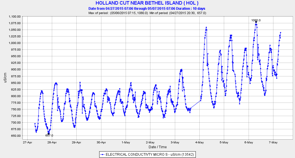
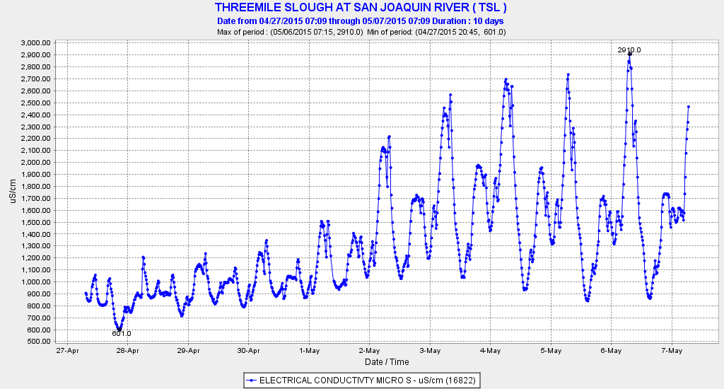
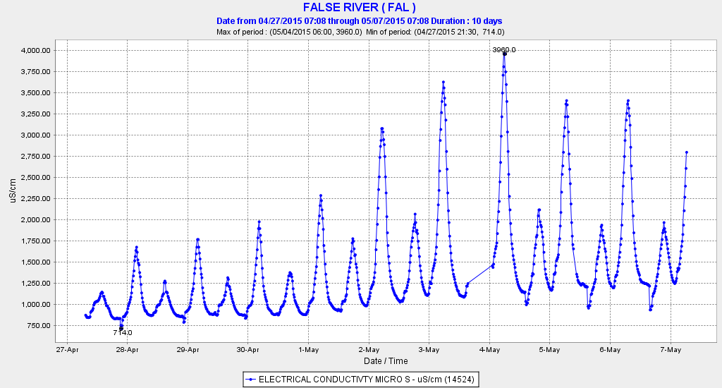
The State Board’s weakened standards require a Net Delta Outflow Index of 4000 cfs and limit south Delta exports to 1500 cfs. 4000 NDOI was achieved during the first three days of the month, but a spring tide pushed into the Delta, resulting in actual negative net Delta outflows (NDOs) that were -6000 cfs on May 2. So much salt pushed into the central Delta (see charts below) that South Delta exports had to be reduced from the allowed 1500 cfs to less than 700 cfs. Export reductions were necessary to stop the salt intrusion and to offset the fact that the exported water was becoming too salty. The Smelt Working Group, at its meeting on May 4,1 expressed no apparent concern about the disappearance of the Low Salinity Zone, or about the fact that the population remnants of Delta and Longfin Smelt were pulled into the south Delta.

Meanwhile, the state and federal water project operators dropped Sacramento River Delta inflow from 6900 cfs on April 30 to 5600 cfs on May 2 (oops). They raised Shasta/Keswick releases on May 2 from 7000 to 7500 cfs after lower river flows near Yuba City dropped to 3500 cfs on May 1, as a result of watering up rice fields in the Sacramento Valley. American River (Folsom Reservoir) releases remained settled in at 1000 cfs.

There is simply no excuse for this poor Delta water management. The moon has been around for billions of years and tides are totally predictable. Export water need not have been 600 EC salinity (barely safe for humans and many crops). The several thousand cfs demands for rice fields in the Sacramento Valley could have been restricted for a few days to allow inflow to offset the spring tides in the Delta. Folsom releases could have been bumped up 500 cfs at least for the weekend rafters.

The salt will take a few days to be flushed out by neap tides, but spring tides and salt will soon return. Will Delta water managers be ready?

Salinity (EC) from 4/27-5/7 at Holland Cut in the South Delta on Old River – a primary source of South Delta exports.

Salinity (EC) from 4/27-5/7 at Holland Cut in the South Delta on Old River – a primary source of South Delta exports.

Salinity (EC) from 4/27-5/7 at Threemile Slough -  the connection between the Sacramento and San Joaquin rivers near Rio Vista.  It is a major channel for incoming tides into the central Delta.

Salinity (EC) from 4/27-5/7 at Threemile Slough – the connection between the Sacramento and San Joaquin rivers near Rio Vista. It is a major channel for incoming tides into the central Delta.

Salinity (EC) from 4/27-5/7 at False River - the major connection between the western and central Delta at Franks Tract and Old River.  It is a major channel for incoming tides into the central Delta.

Salinity (EC) from 4/27-5/7 at False River – the major connection between the western and central Delta at Franks Tract and Old River. It is a major channel for incoming tides into the central Delta.

Spring Actions to Save Delta Smelt

The Smelt Working Group in its April 13 meeting notes1 confirmed that the Spring Kodiak Trawl Survey has recorded record low numbers of adult Delta Smelt in both its March and April surveys. The record lows are consistent with the record low 2014 Fall Midwater Trawl Index. The Group also noted few young Delta Smelt have been collected in the April Smelt Larval and 20-mm surveys. No fisheries agency has objected to State Water Board’s April 6 Order in which the Board reduced the spring Delta outflow standard to 4000 cfs, reduced San Joaquin flow to 200-300 cfs, and moved the salinity standard location for X2 upstream to Threemile Slough provided South Delta exports are held to 1500 cfs.

Given the present state of the smelt populations, the expected habitat conditions this spring and summer will be extremely stressful to the minimal population of this year’s brood of young smelt. As was the case last year, young smelt will be confined to western, central, and northern Delta portions of the lower Sacramento River, lower San Joaquin River, Cache Slough, and Threemile Slough. Exports of 1500 cfs may be insignificant when Delta inflows are 20,000 cfs, but they are not insignificant when inflows are only 6000 cfs. In low inflow conditions, exports pull warm water into the Low Salinity Zone (LSZ), which along with its upstream position leads to lethal or near lethal water temperature (>23C) by the end of spring. Already, May water temperatures will reach or exceed 20°C. The exports also reduce the food productivity of the LSZ through the export of nutrients and plankton.

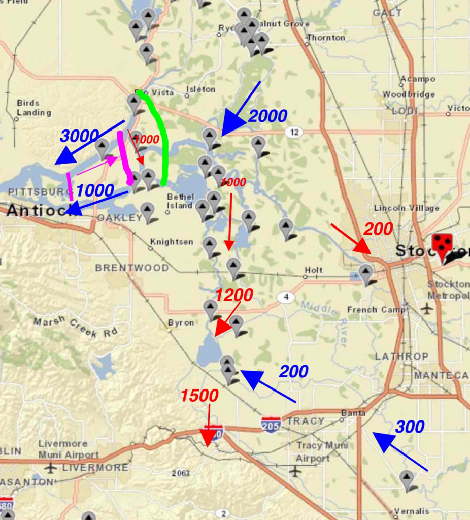
Mid-April conditions were not extreme (Figure 1) because a mandated San Joaquin River pulse flow kept flows moving in a general downstream direction. However, as the pulse flow ended in late April and the State Board Order took full effect, conditions for Delta Smelt deteriorated quickly (Figure 2). There were three primary negative effects:

  1. Reduced Delta outflow, which results in X2 and LSZ moving upstream. (Magenta arrow in Figure 2.)
  2. Negative net flow in Threemile Slough, which pulls Delta Smelt into the central Delta from the north Delta. (Red arrow located just south of Rio Vista in Figure 2.)
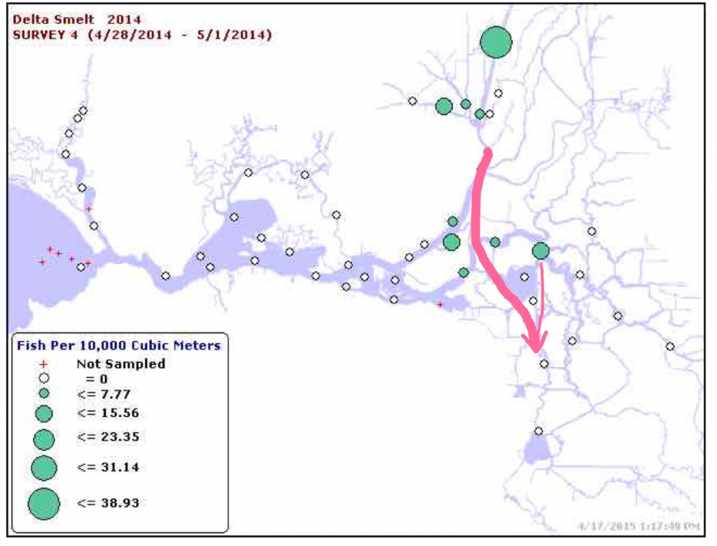
  3. Net flow from the north and central Delta toward south Delta export pumps (Figure 3).

Spring Actions

The following actions would reduce the negative effects on Delta Smelt:

  1. Increase Delta outflow by 1000-2000 cfs, at least during “spring tides”.
  2. Open the Delta Cross Channel during the daytime to increase inflow into the central Delta from northeast by 1000 cfs. (This would reduce net negative flows from north Delta to central Delta via Threemile Slough). Any effect on migrating Sacramento River salmonids can be largely mitigated by keeping the DCC open only in daytime.
    Install Head-of-Old-River Barrier near Vernalis to limit movement of San Joaquin River salmonids into the south Delta.
  3. Install False River Barrier to eliminate tidal pumping of LSZ and young Delta Smelt from Jersey Point into Franks Tract/Old River via False River (slough just north of Bethel Island).
Figure 1.  Mid-April 2015 approximate hydrology conditions in Delta.  Blue arrows depict flow (cfs) in positive downstream direction.  Red arrows depict OMR and export flows.  Green line depicts location of head of Low Salinity Zone (500 EC) at low tide.  Magenta line depicts average daily location of X2 (2700 EC).  Delta Smelt young generally concentrate between the magenta and green lines in spring. (Map source:  USGS with monitoring stations)

Figure 1. Mid-April 2015 approximate hydrology conditions in Delta. Blue arrows depict flow (cfs) in positive downstream direction. Red arrows depict OMR and export flows. Green line depicts location of head of Low Salinity Zone (500 EC) at low tide. Magenta line depicts average daily location of X2 (2700 EC). Delta Smelt young generally concentrate between the magenta and green lines in spring. (Map source: USGS with monitoring stations)

igure 2.  Expected late-April through May 2015 approximate hydrology conditions in Delta.  Blue arrows depict flow (cfs) in positive net downstream direction.  Red arrows depict OMR and export flows.  Green line depicts location of head of Low Salinity Zone (500 EC) at low tide.  Magenta line depicts average daily location of X2 (2700 EC).  Delta Smelt young generally concentrate between the magenta and green lines in spring.

Figure 2. Expected late-April through May 2015 approximate hydrology conditions in Delta. Blue arrows depict flow (cfs) in positive net downstream direction. Red arrows depict OMR and export flows. Green line depicts location of head of Low Salinity Zone (500 EC) at low tide. Magenta line depicts average daily location of X2 (2700 EC). Delta Smelt young generally concentrate between the magenta and green lines in spring.

Figure 3.  Location of Delta Smelt larvae in late April – early May 2014 from Smelt Larvae Survey.  Arrows indicate primary net flow routes of larval smelt from North and Central Delta to South Delta.

Figure 3. Location of Delta Smelt larvae in late April – early May 2014 from Smelt Larvae Survey. Arrows indicate primary net flow routes of larval smelt from North and Central Delta to South Delta.

  1. http://www.fws.gov/sfbaydelta/documents/smelt_working_group/swg_notes_4_13_2015.pdf

Open the Delta Cross Channel

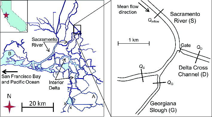
The Delta Cross Channel (DCC) (Figure 1) is closed in spring to minimize the diversion of juvenile salmon from the Sacramento River into the central Delta. However, opening the DCC in May and June will help reduce the detrimental effects of drought on Delta Smelt and Delta water quality.

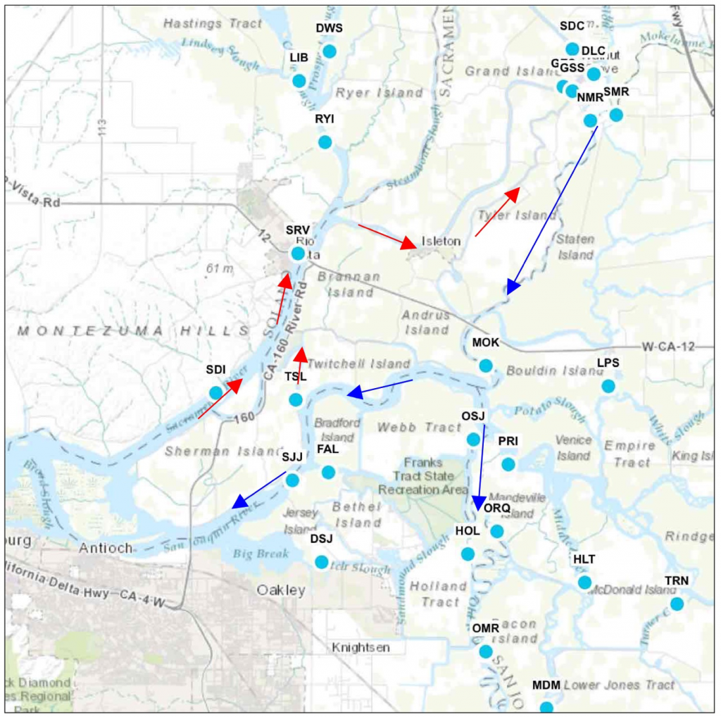
With San Joaquin River inflows to the Delta at extreme lows and the DCC closed, fresh water flow to the south Delta export pumps comes primarily from the Sacramento River via Threemile Slough (TSL) and Georgiana Slough (GGS) (Figure 2). Net flows from both these sloughs are south toward the state and federal pumping plants via Old and Middle Rivers. Delta Smelt enter the central Delta via Threemile Slough. Salmon, sturgeon, steelhead, and striped bass young enter the central Delta via Georgiana Slough as well as Threemile Slough. Opening the DCC will change Delta net flow patterns and contribute to net downstream flows in the lower San Joaquin River in the central Delta (Figure 2), thus benefitting all the fish entering the central Delta including those migrating downstream from the San Joaquin and its tributaries. With the DCC open, less salt will intrude into the central Delta with the more positive net flows of the lower San Joaquin River. Less of the Low Salinity Zone and its concentrations of pelagic fishes including smelt will flow or be tidally pumped upstream into the central Delta. More of south Delta exports will come directly from the Sacramento River via the DCC, rather than through Threemile Slough or Georgiana Slough, or fromthe Low Salinity Zone.

Yes, the late spring migrations of young wild salmon and steelhead, as well as larval Striped Bass and sturgeon from their spring spawns will enter the Central Delta via the DCC, but fewer will enter via Threemile and Georgiana sloughs. Those that do enter the central Delta will benefit from higher net positive downstream flows in the lower San Joaquin River channel to the Bay. Opening the gates only in daytime may provide many of the above benefits while minimizing impacts (Perry et. Al. 2013, 2015).

Perry, R. W., P. L. Brandes, J. R. Burau, P. T. Sandstrom & J. R. Skalski. 2015.
Effect of Tides, River Flow, and Gate Operations on Entrainment of Juvenile Salmon into the Interior Sacramento–San Joaquin River Delta
Transactions of the American Fisheries Society. Volume 144, Issue 3, 2015, pages 445- 455.

Perry, R. W., P. L. Brandes, J. R. Burau, A. P. Klimley, B. MacFarlane, C. Michel, and J. R. Skalski. 2013. Sensitivity of survival to migration routes used by juvenile Chinook Salmon to negotiate the Sacramento–San Joaquin River Delta. Environmental Biology of Fishes 96:381–392.

Figure 1.  Location of Delta Cross Channel gate.

Figure 1. Location of Delta Cross Channel gate.

Central Delta net flow changes from opening Delta Cross Channel

Figure 2. Central Delta net flow changes from opening Delta Cross Channel (DLC in map). Blue arrows are increased net flows. Red arrows signify decrease in net flows. Blue dots indicate CDWR CDEC flow gages. (Base Map Source: CDEC)

April 20, 2015 Smelt Working Group

The Smelt Working Group (SWG) was created as a requirement of biological opinions for the operation of the State Water Project and Central Valley Project under federal and state endangered species acts (ESA/CESA). The SWG is an eclectic mix of federal and state scientists and engineers whose mandate is to provide recommendations to managers on how operate the Delta to protect the ESA/CESA-listed Longfin and Delta smelt. The group holds weekly meetings. Often the meeting notes do not reflect real concerns of group members. One hopes that this is true in this case; the data and the conclusions don’t appear to line up.

At its April 20, 2015 meeting1, the SWG described the following baseline population conditions:

  • The 2014 Fall Midwater Trawl Annual Index for Delta Smelt was 9. This was a record low since the survey began in 1967. With historical indices above 1000 and 600-800 from 2000-2002, an index of 9 is catastrophic.
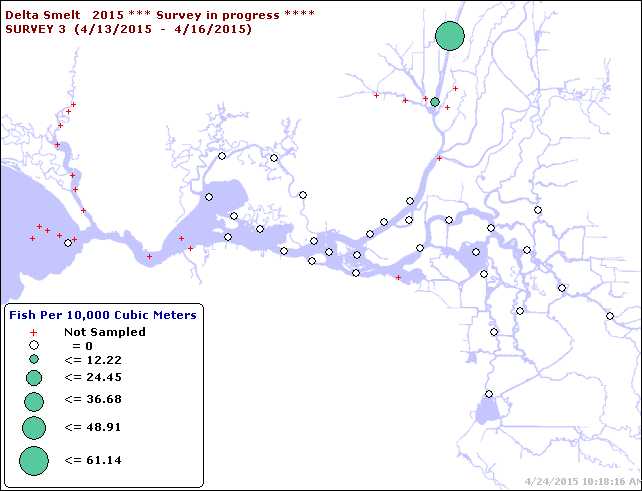
  • Only three Delta smelt were captured in 20-mm Survey #2 (3/30/15-4/8/15). Only one was captured in Survey #3, although an additional 19 were captured at a previously unsampled site further up the Sacramento Deepwater Shipping Channel (4/13-4/16).
  • Spring Kodiak Trawl Survey #4 was in the field the week of April 6, capturing just one Delta smelt. This is also a record low, as were the February and March survey catches.
    Delta Smelt

Delta Smelt

The SWG “agreed” on April 20 that there was no need to modify exports from their current 1500 cfs level or to modify Old and Middle River (OMR) reverse flows of -2000 cfs to protect Delta smelt. (They were probably thinking there were no smelt left to be concerned about – see Figure 1). In reality, the risk to the few remaining Delta Smelt from these flows moving towards the south Delta pumps is extremely high, even higher than that for Longfin Smelt.

Longfin Smelt

The SWG also concluded there was no concern for Longfin Smelt (CESA listed only), despite multiple indicators to the contrary.

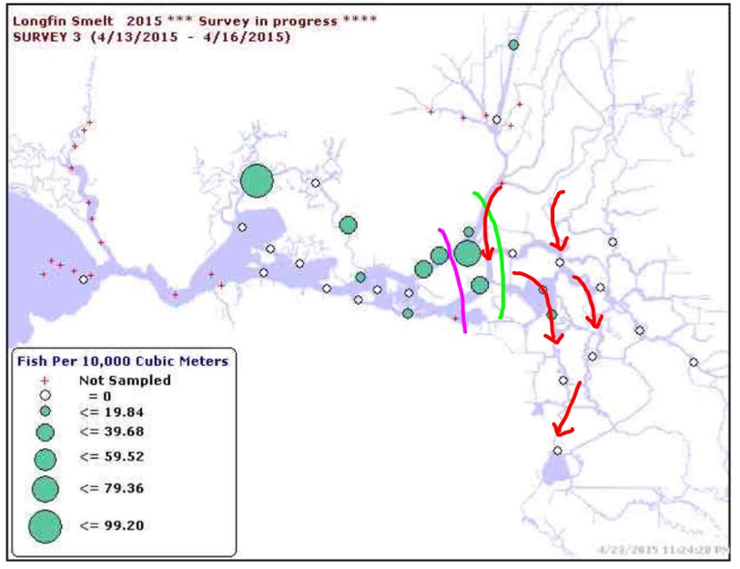
  • Between April 13 and 15, four juvenile Longfin Smelt were salvaged at the CVP pumps and 12 at the SWP pumps; at the same time, a single larva was observed in the larval fish samples at the CVP pumps and four larvae at the SWP pumps. Continued collections in salvage are expected. The SWG concluded that catches in the central and south Delta were not sufficient to reach concern levels based on density or distribution. Note: the odds of a Longfin larvae or juvenile making it all the way to the south Delta, getting through Clifton Court Forebay, and getting salvaged in infrastructure designed to capture much larger fish, are almost infinitesimal. The numbers collected represent a significant take (kill) of Longfin Smelt just from entrainment into the pumping plants. The population’s present distribution and present Delta hydrodynamics support a much higher risk assessment (Figures 2 and 3).
  • Larval densities appeared to increase in the central Delta during 20-mm Survey 2. Nonetheless, the SWG concluded that since exports are very low and most larvae are believed to be outside of the region of entrainment, risk of entrainment remains very low. Note: Larval and juvenile Longfin are obviously not outside the influence of the south Delta exports. Net transport of these planktonic fish from the west, north, and central Delta is toward the south Delta.
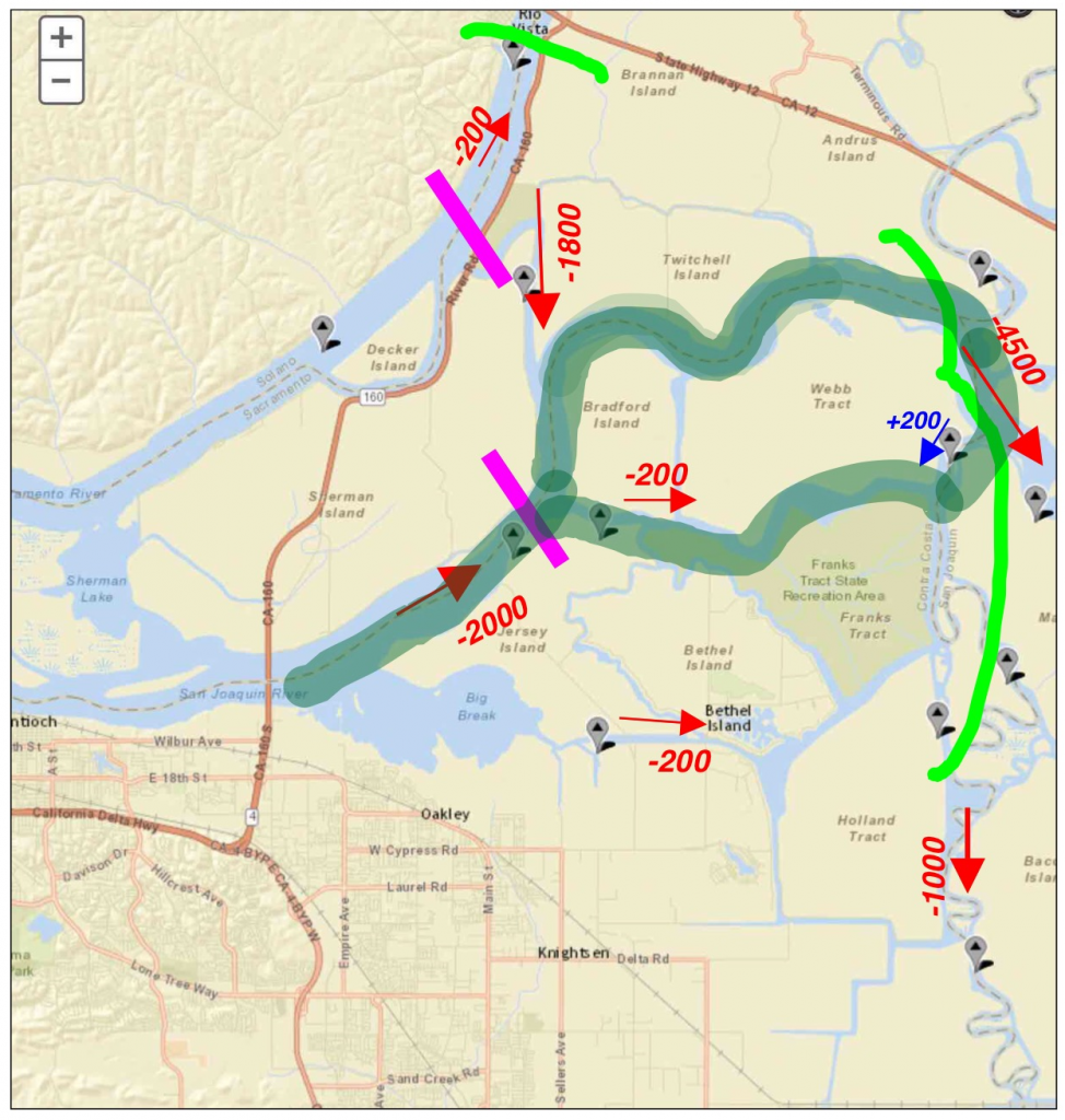
  • The SWG concluded that current conditions, particularly the Old and Middle River (OMR) index projected between -1,900 and -2,000 for the week and slightly positive flow at Jersey Point (Qwest), indicate very little risk for fish that do move into or hatch within the central Delta. Thus, they concluded that the overall risk of entrainment remains very low. Note: Figure 3 shows a -2000 cfs Qwest flow at Jersey Pt at Jersey Island. All the indicators show potential for entrainment. The SWG also knew the pulse flow in the San Joaquin River would soon be ending and that conditions (and risk factors) would be worsening in late April.
Figure 1.  Mid April Delta Smelt distribution in 20-MM Survey .

Figure 1. Mid April Delta Smelt distribution in 20-MM Survey2.

Figure 2.  Mid-April Longfin Smelt distribution in 20-MM Survey.  Also shown is approximate location of X2 (2640 EC salinity) at magenta line and head of Low Salinty Zone (500 EC salinity) at green line.  With real Delta outflow near zero, Delta inflow is predominantly from north and passes across the Delta red arrows to south Delta export pumps.  A portion of the inflow passes through the upper Low Salinity Zone (between magenta and green lines).  Net negative flows and tidal pumping (high volume flood tides) move smelt into central and southern Delta.

Figure 2. Mid-April Longfin Smelt distribution in 20-MM Survey. Also shown is approximate location of X2 (2640 EC salinity) at magenta line and head of Low Salinty Zone (500 EC salinity) at green line. With real Delta outflow near zero, Delta inflow is predominantly from north and passes across the Delta red arrows to south Delta export pumps. A portion of the inflow passes through the upper Low Salinity Zone (between magenta and green lines). Net negative flows and tidal pumping (high volume flood tides) move smelt into central and southern Delta.

gure 3.  Net hydrodynamic conditions during mid-April “spring” tides (highest elevation of flood tide in April lunar cycle).  Magenta line is high tide location of X2 (2640 EC salinity).  Light green line is high tide location of head of Low Salinity Zone (500 EC salinity).  Longfin and Delta smelt larvae generally concentrate in waters whose salinity is between these two values.  Net flow direction is shown with arrows, red being negative.  Dark green highlight area is approximate location of mid-April central Delta plankton bloom (chlorophyll levels above 10 micrograms per liter).  (Data sources: CDEC and USGS.)

Figure 3. Net hydrodynamic conditions during mid-April “spring” tides (highest elevation of flood tide in April lunar cycle). Magenta line is high tide location of X2 (2640 EC salinity). Light green line is high tide location of head of Low Salinity Zone (500 EC salinity). Longfin and Delta smelt larvae generally concentrate in waters whose salinity is between these two values. Net flow direction is shown with arrows, red being negative. Dark green highlight area is approximate location of mid-April central Delta plankton bloom (chlorophyll levels above 10 micrograms per liter). (Data sources: CDEC and USGS.)

April 2015 Framework of Actions for Managing the Sacramento River

In an April 13 post1 I discussed what happened in 2014 that led to the catastrophic loss of much of the Winter Run Chinook Salmon production in the Sacramento River when Shasta Reservoir’s cold-water pool was depleted by the end of August.  With a better temperature model, more knowledge of how to manage Shasta’s cold-water pool, and more volume in the cold-water pool this year, the agencies believe they can make it through the summer of 2015 while supplying the same amount of water to the Sacramento River Settlement Contractors (SRSC) with the same end of September storage as last year.

On April 20, 2015, the Bureau of Reclamation released a “Framework” for managing Shasta storage and the Sacramento River in 20152.  The problem with the Framework is that there are no details as to how the state goals of protecting Winter Run while delivering the same amount of water to SRSC in 2015 as last year will be accomplished.

“Agreement on Sacramento River and SRSC operations is the cornerstone to the overall operations of our water management system, and is a key piece needed before other decisions about volume and timing of transfers to junior water rights holders can be negotiated…. This type of creative, cooperative approach among project operators, regulators, and water users is fundamental to getting the most out of our limited water resources….  We must continue close coordination as we implement the plan, reacting to real-time conditions and balancing the inevitable tradeoffs.”  The problem with this statement is that it was also true for last year.  Despite these same efforts, over 95% of the endangered Winter Run salmon production below Shasta was lost last summer to failed efforts.

“Last year, endangered winter-run Chinook salmon redds in the upper Sacramento River were severely impacted by the lack of cool water,” said Maria Rea, Assistant Regional Administrator for NOAA Fisheries Central Valley Office. “This year we will continue to monitor the temperatures and operations of the Sacramento River throughout the summer.”  Part of the cause of widespread mortality of the 2014 Sacramento River cohort of Winter Run salmon was lack of cold water, but only part.  In addition, salmon redds were physically dewatered and eggs and fry were stranded.  This could occur again this summer.  When monitoring indicated there was a problem last summer, it was too late to take action.

 “A major component of the overall framework is the temperature management plan for the Sacramento River. With the proposed temperature management plan and anticipated CVP operations assuming conservative inflow estimates, storage in Shasta Lake is projected to be approximately 1.1 million acre-feet at the end of September 2015. Water storage and releases from Shasta Lake will be managed carefully to assure the availability of water for multiple beneficial purposes during this fourth year of drought.”  This is the same end-of-summer storage level as last year.  Water storage, releases, and water temperatures were managed last summer.  What specifically will change to ensure that last year’s problem will not reoccur?  The Bureau’s website offers no clue.

“Reclamation will submit the temperature management plan to the State Water Resources Control Board next week as required by the recent Temporary Urgency Change Order.”  The plan will be based on this year’s conditions and a new temperature model.  What assurances do we have that this year’s plan and model will work better than last year’s?

In order to save salmon in 2015, the Bureau Reclamation proposes: “The following actions are designed to help increase the available cold-water resources, improve habitat for Chinook Salmon, and inform real-time adjustments to the temperature management actions, all of which serve to improve the overall effectiveness of the temperature management plan:  

  • “The State Water Resources Control Board approved (in part) Reclamation’s April-September Temporary Urgency Change Petition on April 6, 2015, which will maintain minimum flows for fish downstream in the Delta. This will help Reclamation preserve as much cold water as possible in Lake Shasta for its operations and temperature management throughout the spring and summer as well as for water supply purposes.” (Note:  minimum required lower Sacramento River flows are adequate to maintain minimum Delta inflow and outflow requirements.  Shasta releases are necessary only for required in-river flows and water temperatures and to meet SRSC irrigation deliveries.)
  • “Biologists from the State and Federal fish agencies will be working in the Sacramento River this summer collecting data to help inform Reclamation operations and temperature management decisions in real time. This work will also provide additional data on salmon spawning and rearing that will be useful in future operations during both dry and wet years.”   (Note: the agencies have been collecting data for many years, including last year, when Winter Run mortality was extremely high.)
  • “For the remainder of 2015, the SRSCs, working with the state and federal fishery agencies and conservation partners, will aggressively implement projects included in the Sacramento Valley salmon recovery program. This includes actions to improve spawning in the upper Sacramento River, protect (against) stranding and increase the survival of salmon smolts.” (Note:  How will the contractors contribute to these actions?)
  • “A significant portion of the anticipated water transfers from the SRSC’s will be released in the late summer and fall on a schedule that will provide beneficial habitat conditions for spawning fall-run salmon.” (Note: this was done last year.  Summer transfers would continue to deplete the cold-water pool and degrade the critical habitat of listed smelt in the Delta by increasing Delta exports.  Fall transfers through the Delta are also detrimental and not normally allowed.)
  • “The federal and state agencies and SRSC’s will have regular meetings to coordinate these actions and will work closely together throughout the year to assure the effective implementation of this plan. We all agree that we stand a better chance of managing limited water supplies with continued communication and cooperation.”  (Note: last year, there was ample communication, yet most of the fish perished.  What will cause the agencies to make better decisions this year?)

Some key facts:

  • Last year Shasta started with 2.4 million acre-ft and ended up with 1.1 million acre-ft (Figure 1). This year the plan is to start with 2.7 million acre-ft and end with 1.1 million acre-ft.  (Note that the benefits of this year’s higher spring storage level is offset by a reduced snowpack)
  • The Bureau states that the Shasta cold-water pool has 0.7 million acre-ft more at the beginning of this year than last year.
  • Last year the Bureau ran out of cold water, resulting in lethal water temperatures and low dissolved oxygen for salmon eggs and fry in spawning reach near Redding, and then dropped flows too low, resulting in dewatered redds.
  • Reservoir releases were too high in spring and too low in late summer and fall for good salmon survival (Figure 2).

In conclusion:

  1. There are no plans to save Shasta storage for carryover for next year despite the 300,000 acre-ft additional storage this year.
  2. There is no explanation for how summer deliveries in 2015 that are functionally equivalent to summer deliveries in 2014 will maintain the cold-water pool in Lake Shasta this year when they caused last year’s disaster.
  3. There are no assurances that late summer and early fall flows will be high enough to avoid dewatering salmon redds near Redding.
  4. There are no assurances that addition summer and fall reservoir releases will not be needed to sustain the Bay-Delta ecosystem.
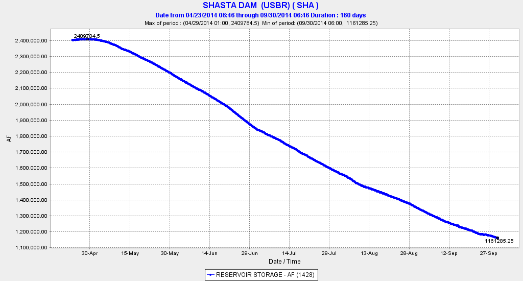
Figure 1.  Shasta Reservoir storage 2014. Source: CDEC.
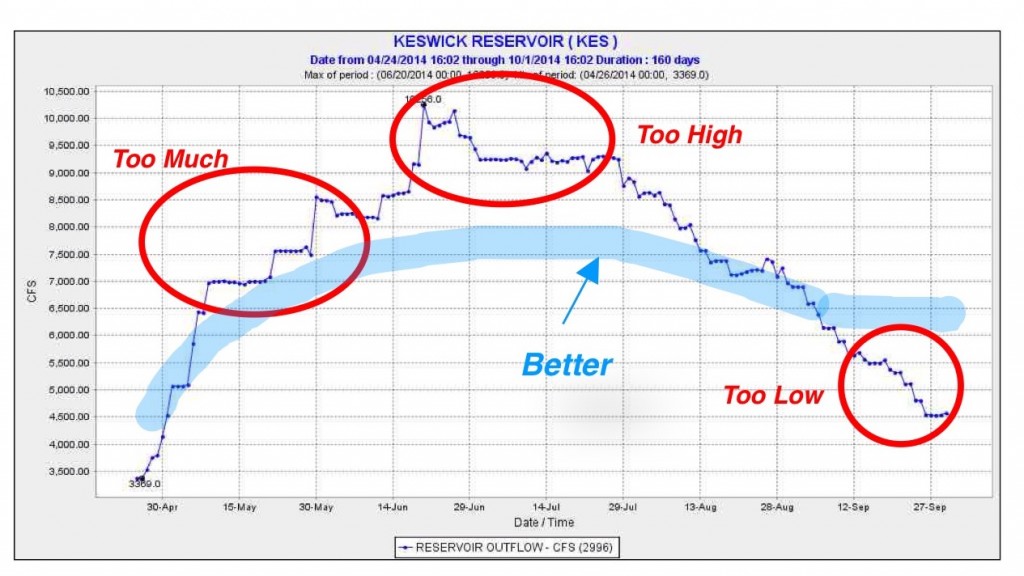
Figure 1. Shasta Reservoir storage 2014. Source: CDEC.

Figure 2. Shasta Reservoir releases 2014. Source: CDEC.