The Need to Better Manage Water Temperatures (and Streamflows)
In this spring of Above-Normal Water Year 2024, with Central Valley storage reservoirs nearly full, warm water temperatures have again plagued salmon rivers. Spring is important, especially for winter-run salmon that are beginning to spawn in the upper Sacramento River near Redding. It is also important for spring-run salmon just finishing their runs up the Sacramento River to and into spawning tributaries to hold until the early-fall spawning season.
Juvenile salmon (smolts) also head to the ocean in spring. If the waters are too warm, salmon smolts suffer stress, stored nutrient depletion, poor growth, higher predation rates, and even direct heat-induced mortality. Water temperatures above 75-77oF are generally lethal under extended exposure. Waters above 70-72oF are highly stressful and generally avoided by salmon. Best migrating temperatures are less than 65oF and should not exceed 68oF. Best spawner-holding temperatures are less than 60oF. Best spawning temperatures are <53.5oF. River inputs to the Delta should be no higher than 65oF in April-May and 68oF in June (and summer).
Salmon Spawning near Redding
Generally, water temperatures are not a problem in the upper Sacramento River below Shasta Dam near Redding except during salmon spawning. Salmon spawn year-round in the upper river, and the target maximum spawning temperature in recent years has been a cold 53.5oF. The source of this cold-water supply is Shasta Reservoir’s cold-water pool. The water quality standard for the upper river of 56oF has been insufficient to sustain salmon eggs in the gravel; thus the new, lower target.
The new target could not be sustained in drought years 2021 and 2022 (Figure 1) because of insufficient Shasta Reservoir storage and cold-water-pool supply. To conserve cold water for the prime June-August spawning and egg incubating season of the endangered winter-run salmon, Reclamation released warm surface Shasta water (not all from cold-water pool) in April-May of 2021 and 2022 to preserve the cold-water supply for summer spawning (at the expense of April-May winter-run spawning and fall-run salmon in their fall spawning season). The poorly managed 2021 spawning season contributed to poor egg-stage survival and a record low smolt production to the ocean. Warm fall spawning temperatures over the past three decades has contributed to the collapse of the fall-run salmon population of the upper river below Shasta Dam.
The obvious solution here is to better management of multi-year cold-water pool storage in Shasta Reservoir and of water deliveries from that storage in all year types. Carryover storage is critical for ensuring an adequate supply of cold water for the next year. Managing the cold-water pool in low-storage years is also important to ensure against its all-too-frequent late-summer depletion.
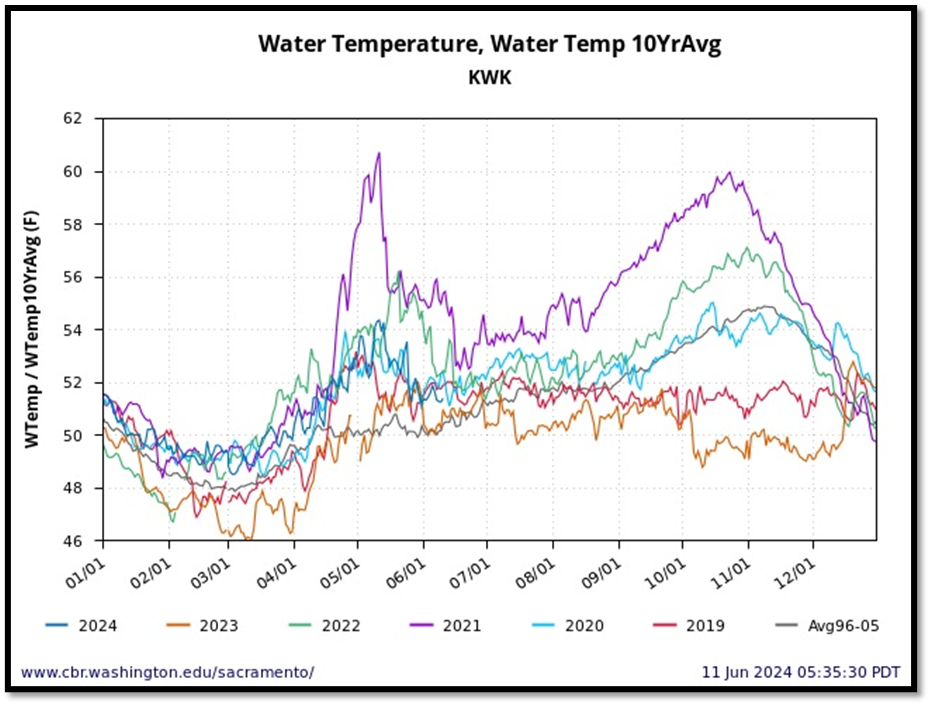
Figure 1. Upper Sacramento River water temperature below Shasta/Keswick dams 2019-2024, with average for the wet decade 1996-2005. Note in drought year 2021 the warm water releases to conserve cold-water pool for summer winter-run salmon spawning. Also note lack of cold-water-pool supply for fall spawning salmon in drier years and the ability to sustain cold water in two recent wet years 2019 and 2023.
Salmon Spawning in Feather River near Oroville
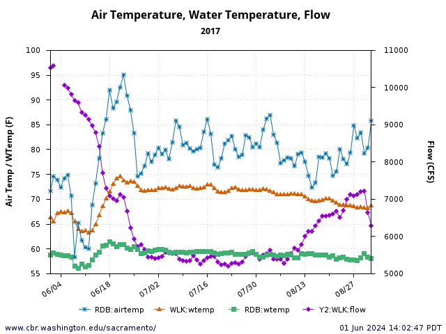
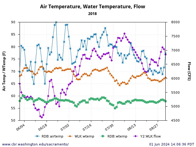
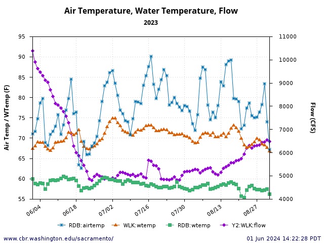
Accommodating the Feather River salmon below Oroville Dam is a complex problem. Spring-run salmon must reach the spawning reach (near Oroville) in the March-June migration season and then hold in the colder low-flow section near the hatchery until early fall spawning. Fall-run migrate in late summer and early fall, and spawn when water temperatures cool in the fall.
Migrating water temperatures are stressful (greater than 65oF) for adult salmon in the lower Feather River in the spring, summer, and fall (Figure 2). Most of the water released from Oroville Reservoir passes through the large shallow afterbay complex before entering the high flow channel near Oroville.
Only the hatchery and low-flow spawning channel reach receive the direct cold-water releases from Oroville Dam (Figure 3). Holding water temperatures in spring and summer are stressful (greater than 60oF) for adult salmon in the low-flow section. Spawning that would normally occur September-October is delayed in low-storage drier years until November.
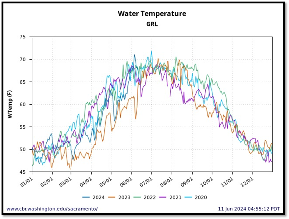
Figure 2. Water temperatures in recent years (2020-2024) in the lower Feather River at Gridley (in the high-flow channel below afterbay complex outlet). Note cooler water temperatures in wet year 2023 and spring 2024.
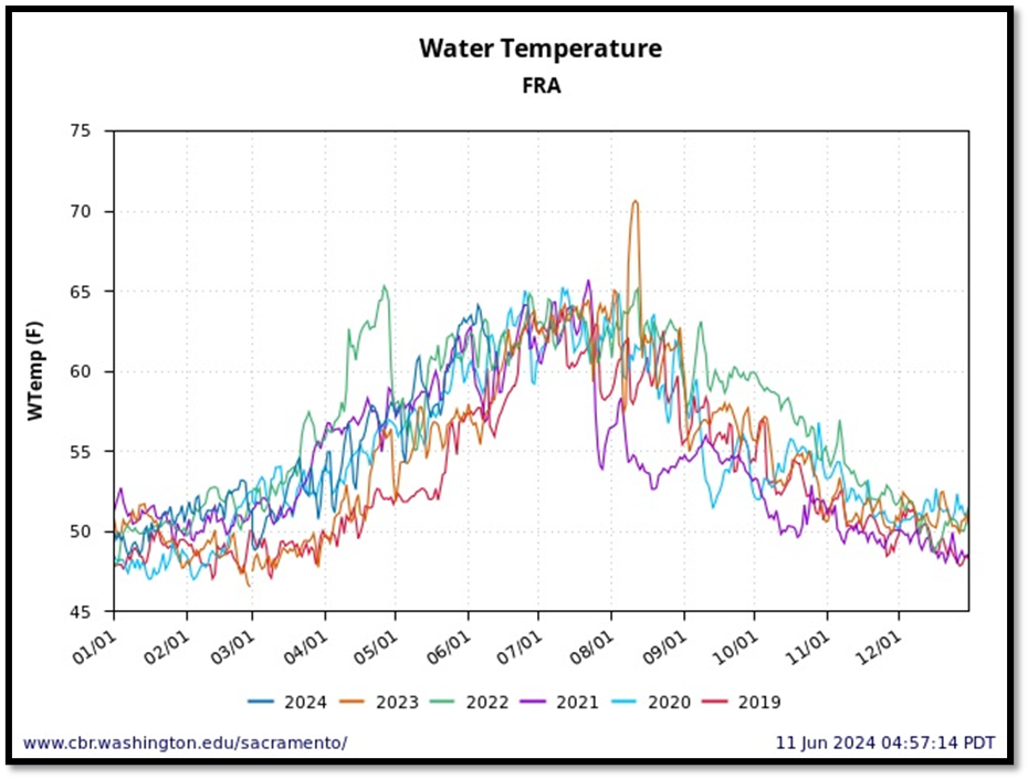
Figure 3. Water temperatures in recent years (2019-2024) in the lower Feather River at Oroville (in the low-flow channel upstream of afterbay complex outlet). Note cooler water temperatures in wet years 2019 and 2023. Also note summer 2023 short-term peak caused by Oroville Dam operations outage. Summer water temperatures in this primary adult spring-run salmon holding reach are generally stressful (greater than 60oF).
Spring-Run Salmon in Sacramento Tributaris
Deer Creek and Mill Creek
While spring-run salmon migrate into Deer and Mill Creeks predominantly in March-April, some migrate as late as May and June. Some later-emigrating smolts also leave the creeks in May and June. These later-immigrating emigrating smolts and adult pre-spawners are subject to warm stressful water temperatures on their journeys, especially in drier years lacking snowmelt. In a wetter year like 2024, stressful water temperatures (>65oF) are not encountered until June (Figure 4). In drought years like 2021, under lower streamflow, stressful water temperatures occur in May, with near lethal temperatures by early June (Figure 5). Maintaining streamflow in wet years in late spring of wet years during heat waves can help to minimize stressful late-spring migration conditions. Maintaining streamflow in April-May of dry years by limiting water diversions can help to minimize stressful water temperatures during the main migration season.
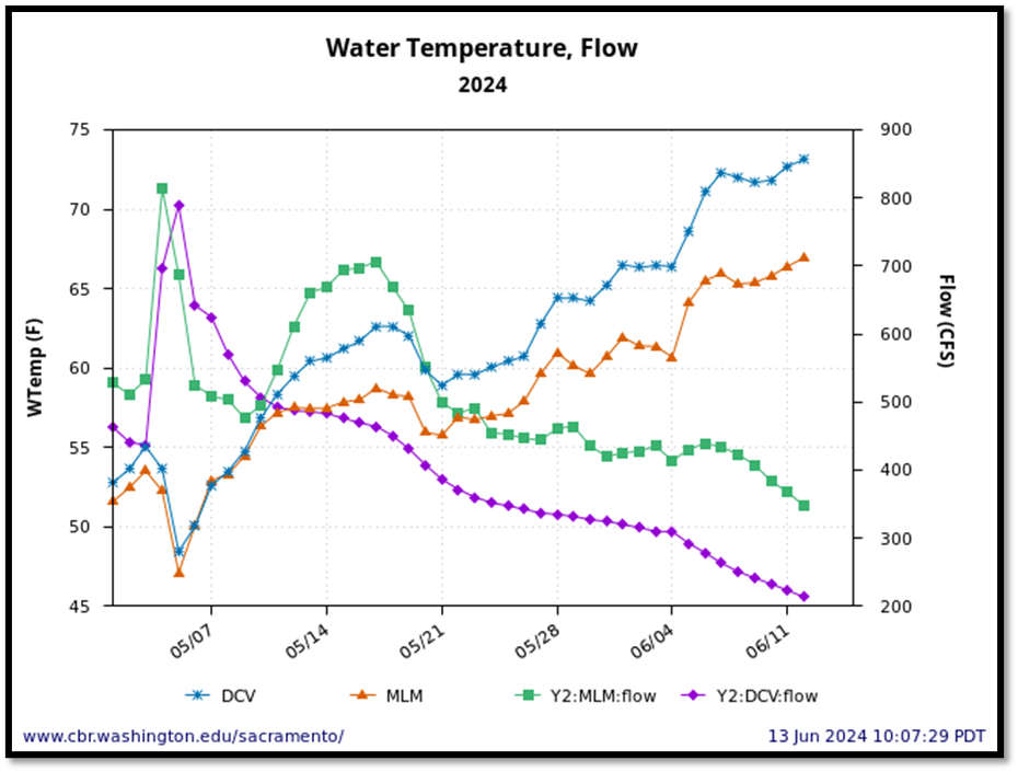
Figure 4. Streamflow and water temperature in lower Deer Creek near Vina (DCV) and lower Mill Creek near Los Molinos (MLM) in spring of above normal water year 2024. Note stressful water temperatures for migrating salmon beginning in early June. Note also slightly lower water temperatures and higher streamflow in Mill Creek compared to Deer Creek.
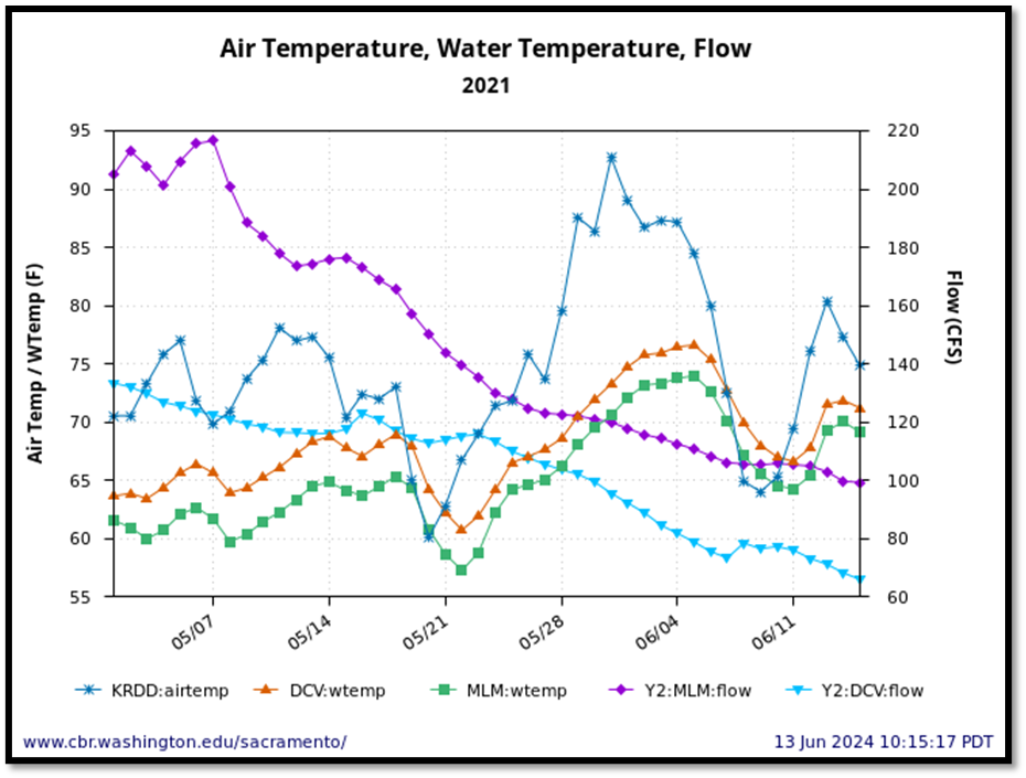
Figure 5. Streamflow and water temperature in lower Deer Creek near Vina (DCV) and lower Mill Creek near Los Molinos (MLM) in spring of drought water year 2021. Air temperature at Red Bluff also shown. Note stressful water temperatures for migrating salmon beginning in early May. Peak water temperatures occurred during late May heat wave. Note also slightly lower water temperatures and higher streamflow in Mill Creek compared to Deer Creek.
Butte Creek
Lower Butte Creek is home to the “Core” endangered spring-run salmon population in the Central Valley. Lower Butte Creek’s spring-run salmon are supported by cold-water transfers from the West Branch of the Feather River. Butte Creek spring-run adult immigrants and smolt emigrants suffer in their late spring (June) migrations from warm stressful water temperature (from higher air temperatures and lower streamflows) in wetter (Figure 6) and drier (Figure 7) years. Summer water temperatures are also high (Figure 8), forcing pre-spawn spring-run salmon to hold near cold-water inputs near Centerville from the West Branch of the Feather River.
In drought year 2021 the summer cold-water source was inadequate and 90% of the estimated 20,000 holding adult spring run salmon died. The 2021 summer die-off coupled with a poor spawning run in 2020, contributed to a record low spawning run in 2023. Poor lower Sacramento River spring river conditions (see next section) also contributed. Maintaining the summer cold-water source for the lower Butte Creek is essential in maintaining the Butte Creek spring-run salmon population.
Figure 6. Streamflow and water temperature in lower Butte Creek near Chico in spring of above normal water year 2024. Note stressful water temperatures for migrating salmon beginning in early June (greater than 18oC/65oF).
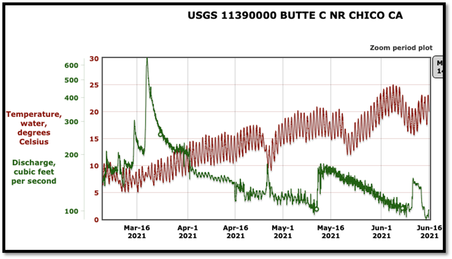
Figure 7. Streamflow and water temperature in lower Butte Creek near Chico in spring of drought water year 2021. Air temperature at Red Bluff is shown in Figure 5. Note stressful water temperatures for migrating salmon beginning in early June (>18oC/65oF). Peak water temperatures occurred during late-May/early-June heat wave with falling streamflow. Note the late-May early-June heat wave (see Figure 5 air temperatures) was likely a contributor to the 2021 die-off of holding adult spring-run salmon.
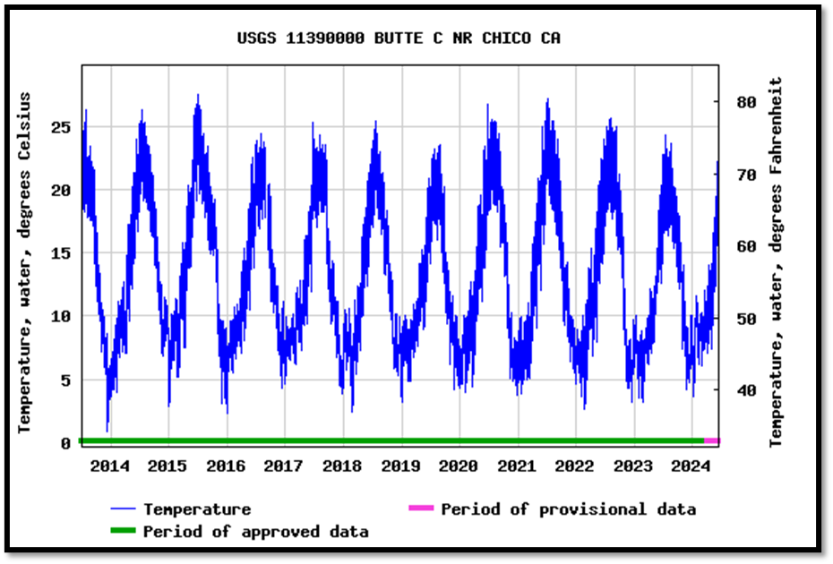
Figure 8. Water temperature in lower Butte Creek near Chico, downstream of adult salmon holding reaches, 2013-2024. Note peak summer water temperatures occurred in summer of critical drought years 2015 and 2021.
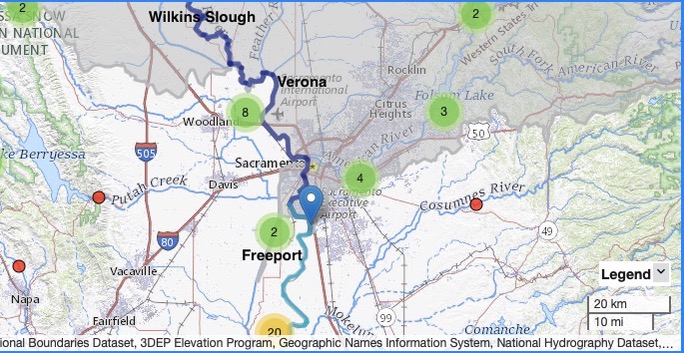
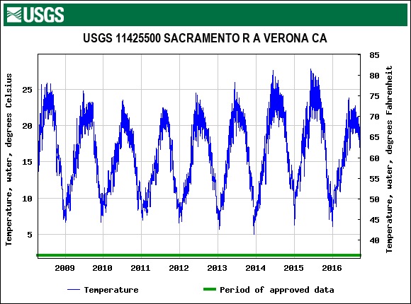
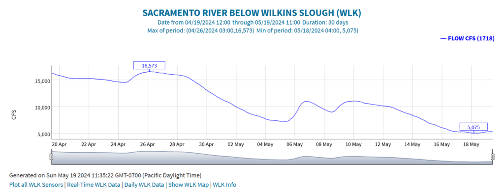
Lower Sacramento River above Delta
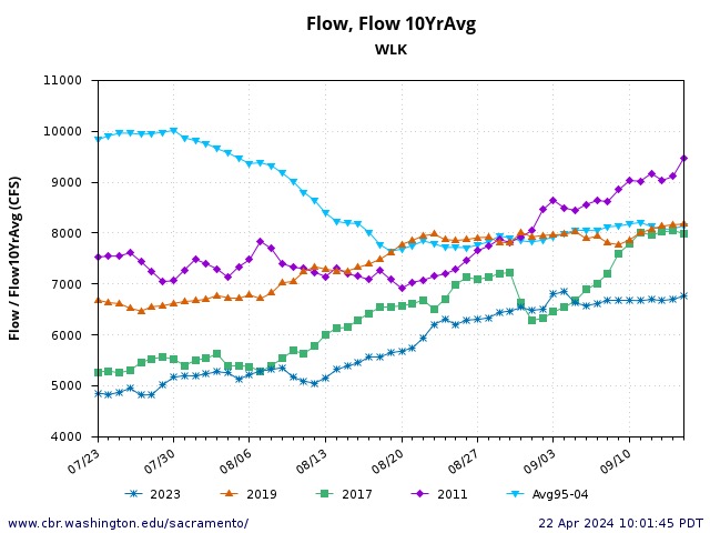
Low flows and high water temperatures in the Sacramento River above and below the confluence with the Feather River, as measured at Wilkins Slough (RM 120) and Verona (RM 90), respectively, contributed to poor spring migration conditions in spring 2024. As Wilkins Slough flows dropped to near 5000 cfs, water temperatures in May rose above 20oC/68oF (Figure 9). Good conditions occurred in spring of wet year 2023, but not in summer (Figure 9). Higher streamflows of 6000-8000 cfs would likely maintain the 20oC/68oF water quality standard and minimize stress to migrating salmon. Increased Shasta Reservoir releases in combination with reduced water diversions from the Sacramento River would remedy these stressful migration conditions. In past years, water contractors deferred some spring irrigation to meet water quality objectives in the lower Sacramento River. Summer conditions are also important because of late-season salmon migrants and for maintaining summer fall-run adult salmon runs in the lower Sacramento River and the Delta.
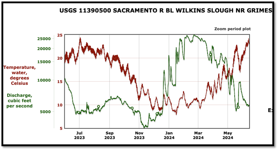
Figure 9. Streamflow and water temperatures at Wilkins Slough (RM 120) in the lower Sacramento River in 2023 and 2024.
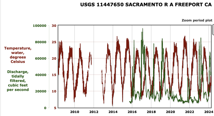
Delta
Sacramento River flows entering the Delta at Freeport in spring 2024 were maintained at 65oF or less. Inflows averaged about 20,000 cfs (Figure 10), with two-thirds of the flow coming from the cooler Feather and American Rivers.
On the San Joaquin River side of the Delta, San Joaquin River flows from 2000 to 5000 cfs are necessary to maintain temperatures below 18oC (65oF) in April-May and below 20oC (68oF) in June (Figure 11). Flows of less than 5000 cfs in June 2024 led to extreme water temperatures (70-75oF). Depending on air temperatures, it takes flows of 2000 cfs or higher to maintain these minimum water temperatures in drier years (Figure 12). Maintaining temperatures below 65oF in April-May and below 68oF in June has only been possible in wetter years (Figure 13).
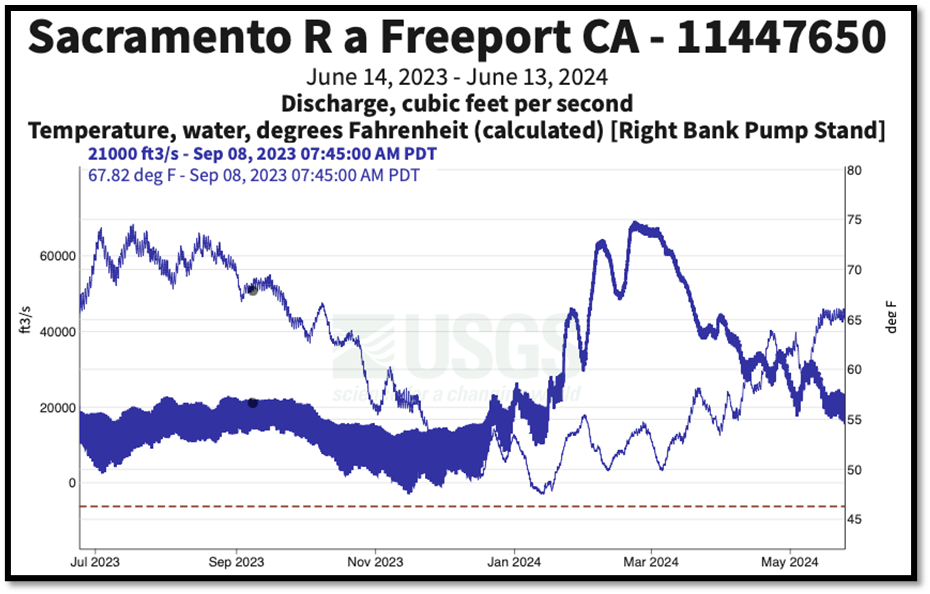
Figure 10. Sacramento River streamflow and water temperature at Freeport in north Delta in 2023 and 2024. Streamflow is darker blue. Note large tidal effects on streamflow at average daily streamflows below 20,000 cfs.
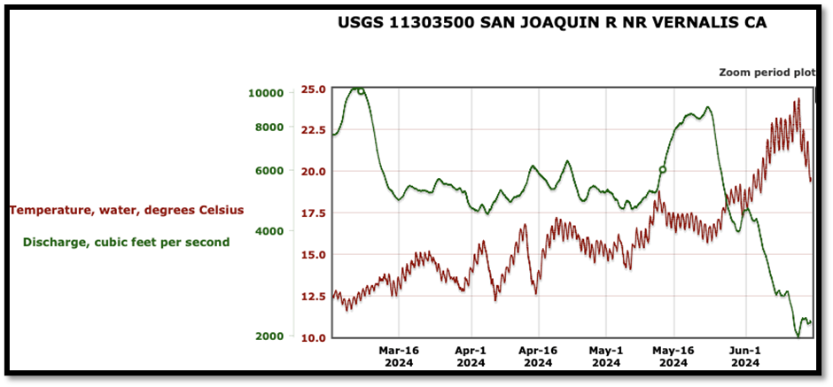
Figure 11. San Joaquin River streamflow and water temperature at Vernalis in south Delta in spring 2024. Note rise in water temperature in June 2024 as streamflow dropped from 5000 cfs to 2000 cfs.
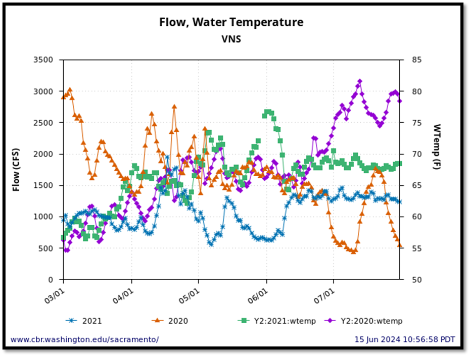
Figure 12. Streamflow and water temperature in San Joaquin River at Vernalis in dry years 2020 and 2021. Note streamflows less than 1000 cfs in May 2021 generally led to water temperatures more than 70oF. Note also streamflows from May-July 2021 near 1500 cfs led to water temperatures less than 70oF.
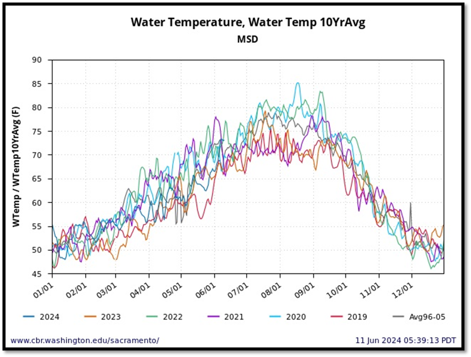
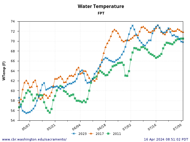
Figure 13. Water temperatures (F) in the lower San Joaquin River at Mossdale in the south Delta from 2019-2024. Also shown is average daily water temperatures for period 1996-2005.
Managing Heat Waves
Over the past two decades, there has been an increase in the number of heat waves each summer in the Sacramento River Valley. The frequency of events with extreme heat with average air temperatures over 90oF has roughly doubled in the last decade compared to the previous decade (Figures 14 and 15)Stressful and lethal water temperatures for salmon are more frequent during heat waves, especially under lower streamflows. The only way to manage the periodic heat stress on salmon is to manage streamflows and water diversions with extraordinary actions in heat waves. This takes coordination between water users and water managers, as well as salmon scientists and regulators.
Heat wave forecasting and water-temperature-related flow actions allow for coordination and potential minimization of heat stress on salmon populations. Combinations of reservoir releases and water diversion rates are possible on regulated rivers like the lower Sacramento, Feather, and American rivers. On unregulated rivers (no storage reservoirs) like Deer and Mill creeks, only limiting water diversions may be actionable.
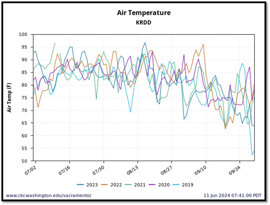
Figure 14. Average daily air temperatures in summers 2019-2023 in Central Valley at Redding Airport.
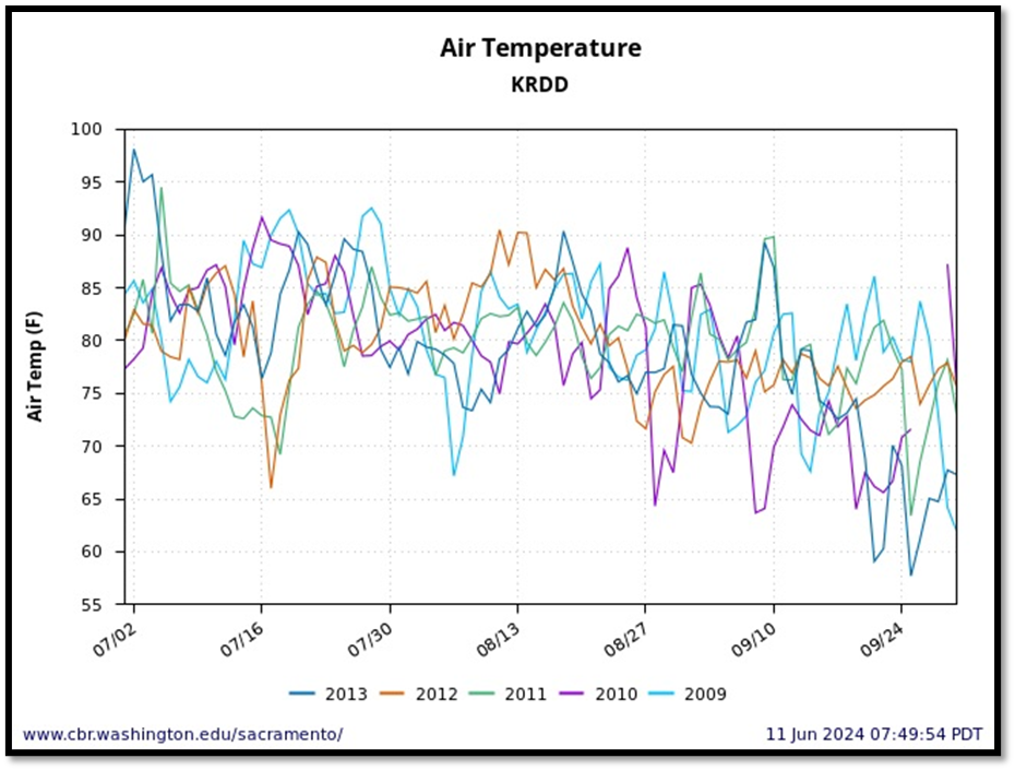
Figure 15. Average daily air temperatures in summers 2009-2013 in Central Valley at Redding Airport.