Experiment – Part 2 Yolo Bypass Flow

Recently I posted about an unprecedented experiment being undertaken as part of the State’s new Delta Smelt Resiliency Strategy July 2016. That experiment now underway (“Experiment 1”) involves increasing Delta outflow in the latter part of July, 2016. The Strategy also included the North Delta Food Web Adaptive Management Projects (“Experiment 2”), management actions that would benefit juvenile and sub-adult Delta smelt by enhancing the north Delta forage supply for Delta smelt. Experiment 2 involves enhancing flow through the Yolo Bypass to the north Delta by closing the Knights Landing Outfall Gates and routing water from the Sacramento River at Hamilton City (GCID intakes) via the Colusa Basin Drain system into the Yolo Bypass to promote food production in areas where Delta smelt are known to occur. The objective of Experiment 2 is to enhance flow and increase nutrient inputs into the tidal north Delta in the Cache Slough-Lower Bypass region. Future food web enhancement flows would also be considered for “additional months in ways that will not conflict with agricultural and waterfowl management actions based on the availability of water to augment flows in the Yolo Bypass. DWR will also explore options for increasing outflow from the Yolo Bypass during the spring.” Experiment 2 also commenced in July 2016 as an “Emergency Action to Help Delta Smelt”.

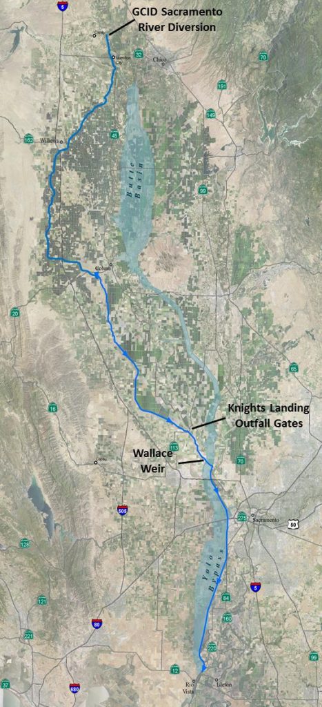
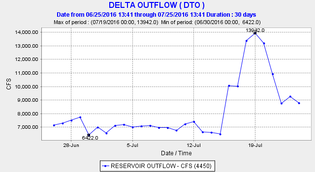
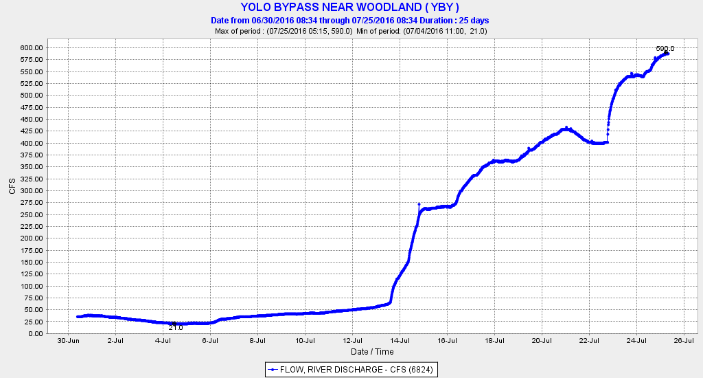
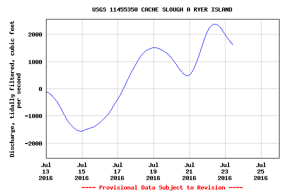
As it turned out, the two experiments were timed together, probably to complement one another. Colusa Basin Drain flows increased in mid-July in Experiment 2 via diversion from GCID intakes at Hamilton City (Figure 1). Delta outflow (Figure 2) was increased in Experiment 1 by reducing Delta exports on July 15. Flow through the Yolo Bypass was increased (Figure 3) by closing the Knights Landing Outfall Gates from the Colusa Basin Drain to the Sacramento River and routing the flow through the Knights Landing Ridge Cut to the upper Yolo Bypass on down to Cache Slough and the North Delta (see route in Figure 1). Net flow through lower Cache Slough (Figure 4) increased from the combined effect of the higher flow in Yolo Bypass and the increased flow through Miners Slough and Steamboat Slough that resulted from reduced exports.

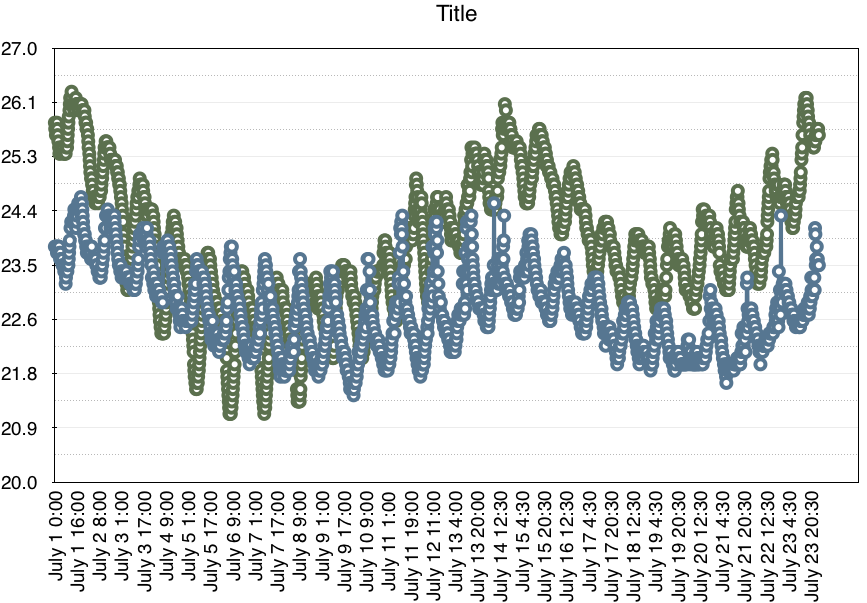
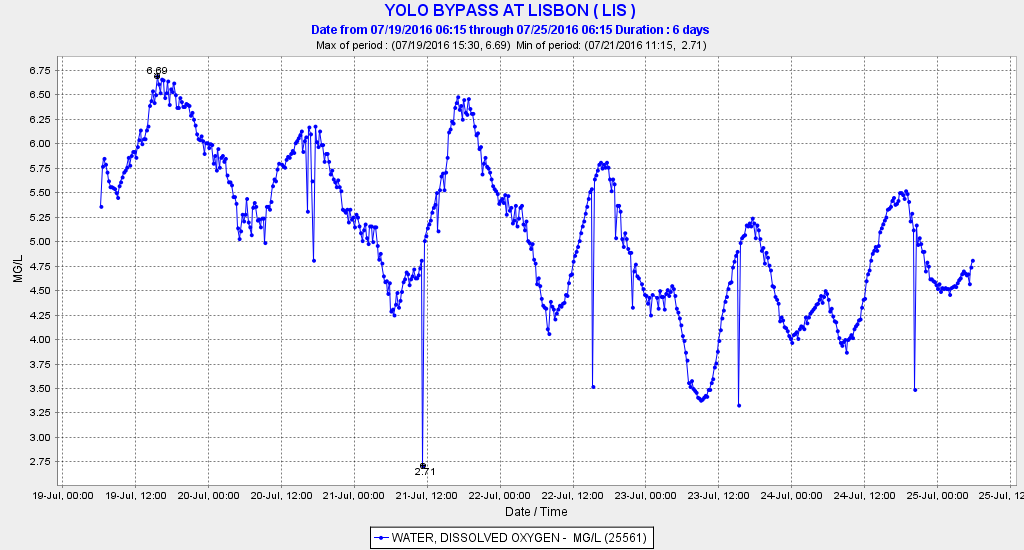
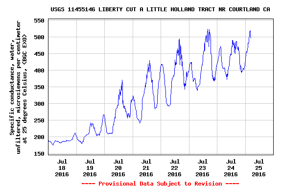
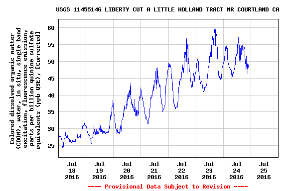
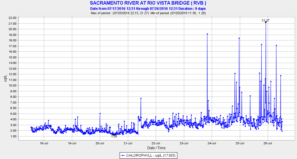
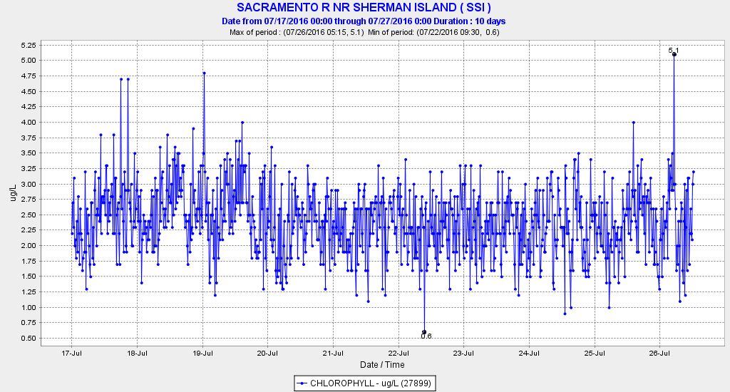
So is Experiment 2 having the desired effects? Water temperature in the upper and lower Bypass continue close to the 80°F mark due to high summer air temperatures, although the water temperature in the lower Bypass’s Tule Canal has been measurably higher than that in the adjacent Ship Channel (Figure 5). The higher flow in the Tule Canal likely carries a high organic load as is evident in the low night-time dissolved oxygen levels of 3 to 5 mg/l (Figure 6). Concentrations of salts (Figure 7) and organic matter (Figure 8) increase in the lower Bypass with higher flow. Plankton productivity as measured by chlorophyll levels in the lower Sacramento River channel at Rio Vista immediately below Cache Slough, though low (<10 micro-grams per liter), shows signs of increasing (Figure 9). However, several miles downstream in the channel at Sherman Island, there has been no sign of an increase in plankton (Figure 10). If an increase is indeed real, it is not clear if it is being caused by the higher Delta outflow, lower Delta exports, higher flow in the Bypass, or some combination thereof.

All in all, the warm nutrient- and organic-laden 500-600 cfs of water from the Colusa Basin agricultural drain moving down the Bypass appears to reach the tidal lower Bypass/Cache Slough complex. There, it mixes with higher net and tidal flows of Cache Slough and the Sacramento River. With 80,000 to 100,000 cfs going back and forth during the twice daily tide cycle between Cache Slough and Rio Vista, the Colusa Basin water from the Yolo Bypass is quickly mixed, and its signature is lost. The key question: is there sufficient “fertilizer” and extra plankton in this foreign water to stimulate plankton food production in the lower Yolo Bypass, Cache Slough and the north Delta to benefit Delta smelt? A reduction in river flow at Hamilton City from Experiment 2 might be considered an impact to Sacramento River fish unless additional water is specifically released from Shasta Reservoir for the experiment, or unless GCID water contractors forgo use of a portion of their allocated diversion at Hamilton City.

At a minimum, Experiment 2 has proved the efficacy of an action that might be even more effective from late fall to early spring when water used to stimulate plankton production in the Delta would augment the benefits of cooler, higher flows in the Sacramento River.

Figure 1. Path of flows diverted from the Sacramento River near Hamilton City. Water will move down through GCID's system, into the Colusa Basin Drain and Knights Landing Ridge Cut, through Wallace Weir and the Yolo Bypass, and into the Delta near Rio Vista. Source: http://www.norcalwater.org/wp-content/uploads/Smelt-action-fact-sheet.pdf

Figure 1. Path of flows diverted from the Sacramento River near Hamilton City. Water will move down through GCID’s system, into the Colusa Basin Drain and Knights Landing Ridge Cut, through Wallace Weir and the Yolo Bypass, and into the Delta near Rio Vista. Source: http://www.norcalwater.org/wp-content/uploads/Smelt-action-fact-sheet..pdf

Figure 2. Delta outflow July 2016.

Figure 2. Delta outflow July 2016.

Figure 3. Flow in the upper Yolo Bypass near Woodland July 2016.

Figure 3. Flow in the upper Yolo Bypass near Woodland July 2016.

Figure 4. Net tidally filtered flow in lower Cache Slough July 2016.

Figure 4. Net tidally filtered flow in lower Cache Slough July 2016.

Figure 5. Water temperature at adjacent stations in the lower Bypass Tule Canal (GREEN) and Ship Channel (BLUE) during July 2016.

Figure 5. Water temperature at adjacent stations in the lower Bypass Tule Canal (GREEN) and Ship Channel (BLUE) during July 2016.

Figure 6. Dissolved oxygen level in the Yolo Bypass Tule Canal at Lisbon 19-25 July 2016.

Figure 6. Dissolved oxygen level in the Yolo Bypass Tule Canal at Lisbon 19-25 July 2016.

Figure 7. Specific conductance of water in the lower Yolo Bypass at Liberty Cut late July 2016.

Figure 7. Specific conductance of water in the lower Yolo Bypass at Liberty Cut late July 2016.

Figure 8. Concentration of dissolved organic matter in lower Yolo Bypass at Liberty Cut late July 2016.

Figure 8. Concentration of dissolved organic matter in lower Yolo Bypass at Liberty Cut late July 2016.

Figure 9. Chlorophyll concentrations in the lower Sacramento River in north Delta at Rio Vista 18-28 July 2016.

Figure 9. Chlorophyll concentrations in the lower Sacramento River in north Delta at Rio Vista 18-28 July 2016.

Figure 10. Chlorophyll concentrations in the lower Sacramento River in north Delta at Sherman Island 17-28 July 2016.

Figure 10. Chlorophyll concentrations in the lower Sacramento River in north Delta at Sherman Island 17-28 July 2016.

An Unprecedented Experiment – July 2016

State’s Delta smelt plan calls for more water flowing to sea” – This headline to a recent Sacramento Bee article speaks of the state and federal governments’ hope to get more water for Delta outflow to the Bay this summer to help Delta smelt after four devastating drought years.  Smelt are at record lows, and their endangered status under the state and federal endangered species acts requires an effort to help recover them.  When the Delta smelt plan was announced, this year’s Summer Delta Smelt Index had just come in at 0.0, the same as it was last summer.

A grand experiment began on July 15.  With Shasta Reservoir releases held low to save cold water for salmon, more Delta outflow for the experiment was provided by reducing exports from 9000 cfs to 2000 cfs.  Deliveries to South-of-Delta CVP and SWP contractors were cut to a minimum, even though the plan had promised: “[no] cuts to water supply planned.”

Conditions on July 12 can be seen in Figure 1.  Reservoir releases and some natural river flow totaled approximately 30,000 cfs.  Most (80%) of the 20,000 cfs of Delta inflow was coming from Oroville and Folsom reservoirs.  Of that amount, only 7000 cfs was leaving the Delta for the Bay (the required minimum outflow in July of a Below Normal year under state standards is 6500 cfs).  Approximately 6,000 cfs was being diverted from the upper Sacramento River below Redding.  Another 3,000 cfs was being diverted from the lower river and its tribs.  Another 4,000 cfs was diverted in the Delta.  Finally, the state SWP was pumping 7000 cfs and federal CVP was pumping 1000 cfs from the south Delta.

By July 15, conditions in the Delta changed.  Delta outflow doubled, while exports were reduced by 80% (Figure 2).

We often hear about “adaptive management” to test things to see if they help or not.   This is a big, very unprecedented adaptive management experiment.  The purpose is to help Delta smelt recover from a dramatic decline over the past two decades.  However, it will be difficult to help what is not there. There were few smelt out there a month ago; hopefully, there are still enough that the experiment will make a difference.

The important thing now with such an experiment is to make sure we learn everything we can from it.  The following are some questions that should be addressed.

  1. What changes occur in flow, nutrients, salinity and water temperature in the Delta and Bay?
  2. If there are no Delta smelt, what changes occur to the other pelagic organisms such as phytoplankton, zooplankton, shrimp, longfin smelt, striped bass, herring, anchovy, and threadfin shad?
  3. Will the change stimulate a plankton bloom that benefits the Bay-Delta estuary?

From the point of view of managing the experiment, it is good that other important factors such as Delta inflow remain unchanged, so that there are not too many variables to filter out as determinative in any response.  It will be difficult enough to determine the relative importance of higher outflow versus lower export.

Hydrology

Preliminary results indicate that the experiment (as expected) had a noticeable effect on Delta hydrology.  By July 24, outflow had dropped back from its peak during the experiment of 14,000 cfs to 9000 cfs (Figure 3), as exports were again increased to about 7000 cfs, as shown in Old and Middle River tidally averaged flow (Figure 4).  Net lower San Joaquin River flow at Jersey Point initially increased sharply in response to the reduced exports (Figure 5).  The net flows diverted from the lower Sacramento to the lower San Joaquin via Threemile Slough were also reduced (Figure 6).

Salinity

Salinity (EC) eventually responded to the higher outflows as the pulse of freshwater pushed westward.  Salinity on the lower Sacramento at Emmaton (Figure 7) and Jersey Point on the lower San Joaquin (Figure 8) declined measurably.  Salinity also declined downstream at the confluence of the two rivers near Collinsville in eastern Suisun Bay (Figure 9).

Water Temperature

There has been slightly lower water temperature in the western Delta.  This is at least partially explained by cooler air temperatures during the experiment.  The water temperature at X2 (location of 2 ppt salinity or 2700 EC declined as X2 was located on-average further west during the experiment  (Figure 10).  However, that too could be explained by lower air temperatures.

Plankton Blooms

So far there is no evidence of enhanced plankton production by the experiment.  There has been little change in chlorophyll measured at selected gaging stations in the central and west Delta.

Fish

While results of Delta-wide fish surveys will not be available for some time, results of export salvage of two pelagic Delta species, striped bass and threadfin shad, showed sharp reductions as expected (Figures 11 and 12).
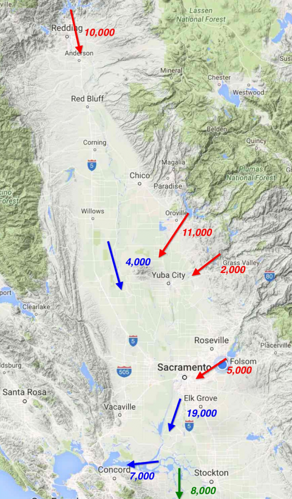
Figure 1. Water conditions in mid July 2016 in the Sacramento Valley and Delta before the experiment. Red denotes major water releases in cfs from the Valley’s four largest reservoirs. Blue denotes three key river flow locations: lower Sacramento River upstream of the Feather River, Freeport coming into the Delta, and Delta outflow. Green denotes south Delta exports.
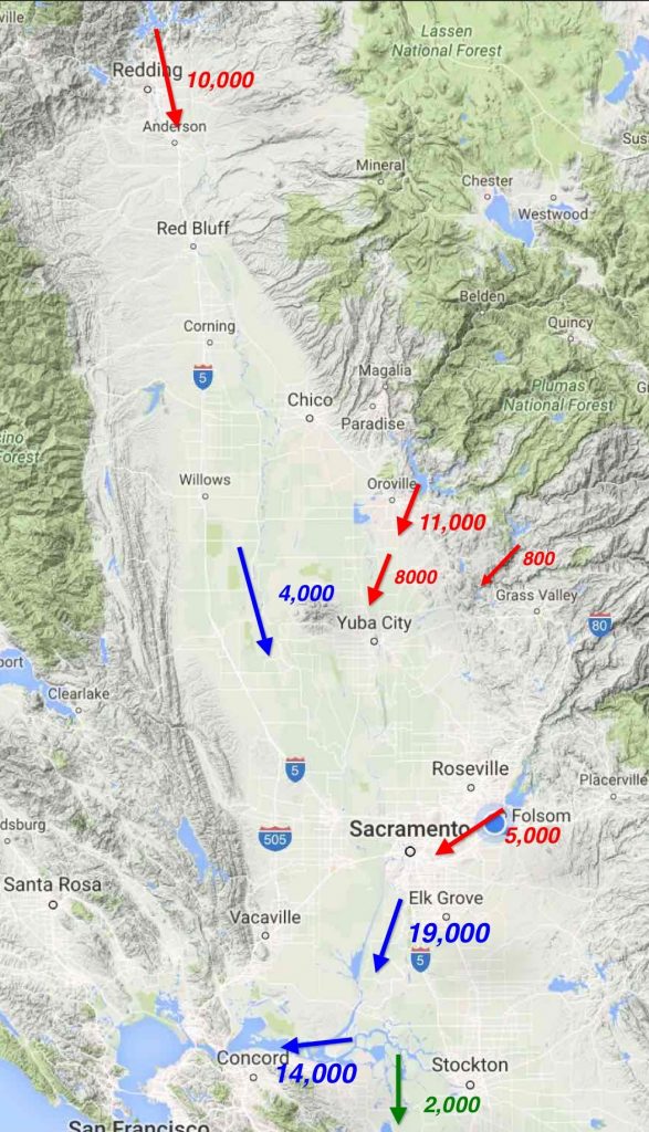
Figure 1. Water conditions in mid July 2016 in the Sacramento Valley and Delta before the experiment. Red denotes major water releases in cfs from the Valley’s four largest reservoirs. Blue denotes three key river flow locations: lower Sacramento River upstream of the Feather River, Freeport coming into the Delta, and Delta outflow. Green denotes south Delta exports.

Figure 2. Flow conditions in the Sacramento Valley and Delta on 20 July 2016. Delta outflow is 14,000 cfs. Sacramento River flow above the mouth of the Feather River was 4,000 cfs. Sacramento River inflow to the Delta at Freeport is 19,000 cfs. (Note total Delta inflow was about 20,000 cfs. Total Central Valley reservoir releases and uncontrolled river inflows was over 30,000 cfs.). About two-thirds of the Delta inflow came from Feather Riverand American River reservoirs. Though only 2000 cfs was being exported from the south Delta projects, approximately 14,000 cfs of Sacramento Valley reservoir releases were being diverted for water supply from Sacramento Valley rivers and the interior Delta. Nearly all San Joaquin Valley reservoir releases were being diverted.
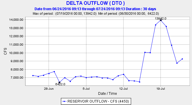
Figure 2. Flow conditions in the Sacramento Valley and Delta on 20 July 2016. Delta outflow is 14,000 cfs. Sacramento River flow above the mouth of the Feather River was 4,000 cfs. Sacramento River inflow to the Delta at Freeport is 19,000 cfs. (Note total Delta inflow was about 20,000 cfs. Total Central Valley reservoir releases and uncontrolled river inflows was over 30,000 cfs.). About two-thirds of the Delta inflow came from Feather Riverand American River reservoirs. Though only 2000 cfs was being exported from the south Delta projects, approximately 14,000 cfs of Sacramento Valley reservoir releases were being diverted for water supply from Sacramento Valley rivers and the interior Delta. Nearly all San Joaquin Valley reservoir releases were being diverted.

Figure 3. Delta outflow increased to 14,000 cfs during the July 15-23 experiment.
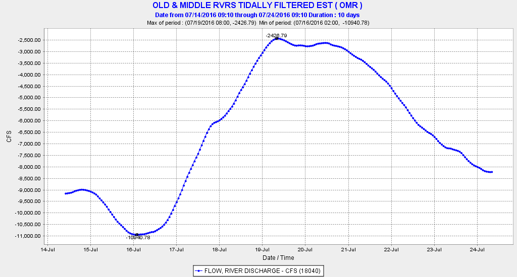
Figure 3. Delta outflow increased to 14,000 cfs during the July 15-23 experiment.

Figure 4. The tidally filter flow in the central Delta showed about a 6500 cfs reduction in the flow in Old and Middle River toward the south Delta export pumps.

Figure 4. The tidally filter flow in the central Delta showed about a 6500 cfs reduction in the flow in Old and Middle River toward the south Delta export pumps.

Figure 5. The experiment brought a sharp response in the tidally filtered flow at Jersey Point in the lower San Joaquin River in the western Delta.
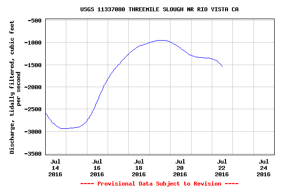
Figure 5. The experiment brought a sharp response in the tidally filtered flow at Jersey Point in the lower San Joaquin River in the western Delta.

Figure 6. The experiment brought a reduction in net flows pulled from the lower Sacramento River to the lower San Joaquin via Threemile Slough.
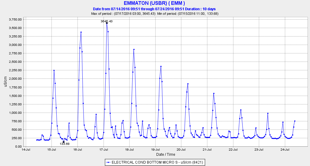
Figure 6. The experiment brought a reduction in net flows pulled from the lower Sacramento River to the lower San Joaquin via Threemile Slough.

Figure 7. Salinity (EC) at Emmaton on the lower Sacramento River just north of Antioch 14-24 July, 2016.
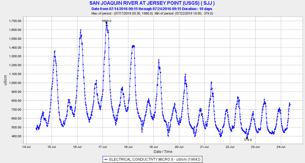
Figure 7. Salinity (EC) at Emmaton on the lower Sacramento River just north of Antioch 14-24 July, 2016.

Figure 8. Salinity (EC) at Jersey Point on the lower San Joaquin River near Antioch 14-24 July, 2016.
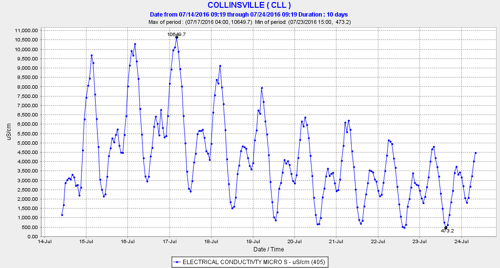
Figure 8. Salinity (EC) at Jersey Point on the lower San Joaquin River near Antioch 14-24 July, 2016.

Figure 9. Salinity (EC) at Collinsville near the confluence of the lower Sacramento and San Joaquin channels in eastern Suisun Bay 14-24 July, 2016.
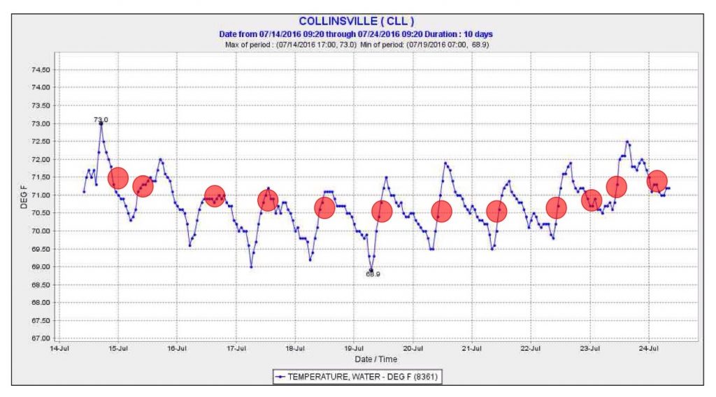
Figure 9. Salinity (EC) at Collinsville near the confluence of the lower Sacramento and San Joaquin channels in eastern Suisun Bay 14-24 July, 2016.

Figure 10. Water temperature (F) at Collinsville in eastern Suisun Bay 14-24 July, 2016. Red dots indicate water temperature when X2 was located at Collinsville

Figure 10. Water temperature (F) at Collinsville in eastern Suisun Bay 14-24 July, 2016. Red dots indicate water temperature when X2 was located at Collinsville

Figure 11. Salvage of striped bass at south Delta export facilities July 1-20, 2016.

Figure 11. Salvage of striped bass at south Delta export facilities July 1-20, 2016.

Figure 12. Salvage of threadfin shad at south Delta export facilities July 1-20, 2016.

Figure 12. Salvage of threadfin shad at south Delta export facilities July 1-20, 2016.

Managing the Delta in Summer to Protect Delta Smelt

During June of this year, there was an effort on the part of the US Fish and Wildlife Service to procure water for summer Delta outflow for Delta smelt. Now the State has announced a similar plan. The summer standards for outflow in this Below Normal water year are a monthly average of 6500 cfs in July, 4000 cfs in August, and 3000 cfs in September. These outflows and the variability inherent in the monthly average standard are not protective of Delta smelt. In a June post, I recommended 9000, 5000, and 4000 cfs, respectively, to protect remaining smelt after four years of drought conditions. No water has been procured, and Delta outflow so far in July has averaged 7000 cfs.

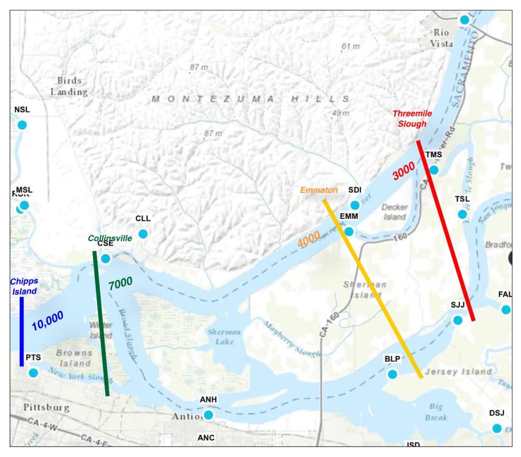
The map below (Figure 1) shows the average location of X2, the location where salinity is approximately 2 parts per thousand (sea water is approximately 30 ppt) at various Delta outflows in cubic feet per second. X2 is the general location of the critical mixing zone of the estuary and the upper end of the Low Salinity Zone (1-6 ppt). The state Delta outflow standard for August is 4000 cfs, which should keep the daily average location of X2 west of Emmaton (EMM) and Jersey Pt (SJJ). This standard is required to protect Delta water quality, keep Delta smelt west of the influence of South Delta exports, and keep emigrating juvenile salmon moving west toward the Bay and Ocean. The standard applies in wetter year types including this year. In drier years, as in the past four years, the standard is 3000-3500 cfs.

The need for the higher July outflow protection stems from the fact that the smelt gradually move westward into more brackish water over the summer. In July they tend to be upstream of X2 in a planktonic stage and vulnerable to being drawn into the central Delta. They are often located at the upper end of the Low Salinity Zone (500-1500 EC) which in July, at 6500 cfs outflow, is vulnerable to exports (see location of Threemile Slough TSL, Jersey Pt SJJ, and False River FAL in Figure 1).

The issue of summer protections for smelt is critical to the future management prescriptions being developed in new water quality standards and smelt biological opinions. That makes it important to water contracting agencies like the Metropolitan Water District:

One of the key things the water contracting agencies are focusing on is the science behind the summer flow. “There’s been nothing that’s been articulated in writing in a comprehensive nature describing the science that leads to this proposal as to what kind of function is this summertime flow providing or what types of changes do they expect to occur for Delta smelt as a result of taking this kind of action,” he [Steve Arakawa, Bay Delta Initiatives Manager of Metropolitan Water District] said. “The water contracting agencies are following this very carefully because of the longer term implication of where such an action could show up in future regulations, whether it’s the biological opinions for the projects or whether it’s the State Water Resources Control Board setting standards and how Fish and Wildlife Service might be making proposals in future regulation proceedings.”… “There has been no clear indication of the science behind the flow proposal,” he said. “There have been discussions about turbidity, temperature, and salinity, but in many cases it’s mainly salinity that is affected by this flow. Whether turbidity or temperature can be affected by the flow is another question or maybe uncertain. Then it’s about with this additional flow, where do the fish go – do they stay in the Suisun Bay, do they go up into the channels into Suisun Marsh, farther up north? All of that is in question. The interest of the water contracting agencies is if this does proceed, is there a thought-out way of measuring the benefits of such proposed flows to monitor where do the fish go, what kind of results do we expect, and whether in fact those results did occur with such action.” 1

Figure 1. Location of X2 (2 parts per thousand salinity) in the Delta at various Delta outflows.

Figure 1. Location of X2 (2 parts per thousand salinity) in the Delta at various Delta outflows.

To protect Delta smelt in early summer (June and July), X2 and the Low Salinity Zone need to be located west of Emmaton and Jersey Point to ensure portions of the LSZ are not drawn into the central Delta from Jersey Point (via False River FAL) or Threemile Slough (TSL). In the following sections, graphs show clearly that such protections did not occur in drought years 2014 and 2015, and as yet not in 2016.
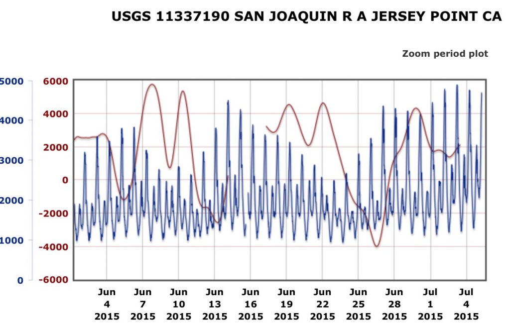
Keeping X2 below Jersey Point requires some daily, even hourly tuning of the Central Valley and Delta plumbing to compensate for tides. The next two charts (Figures 2 and 3) show that EC of 2000-4000 (X2 is about 2700 EC) reaches Jersey Point when tidally-filtered flow falls below zero during spring tides. The LSZ and X2 were at Jersey Point in early summer in both drought years.

Figure 2. Salinity (EC) in blue and tidally filtered flows in red at Jersey Point in early summer 2015. Delta outflows were 3000-4000 cfs in this critically dry year.

Figure 2. Salinity (EC) in blue and tidally filtered flows in red at Jersey Point in early summer 2015. Delta outflows were 3000-4000 cfs in this critically dry year.

Figure 3. Salinity (EC) in blue and tidally filtered flows in red at Jersey Point in early summer 2014. Delta outflows were 3000-5000 cfs in this critically dry year.

Figure 3. Salinity (EC) in blue and tidally filtered flows in red at Jersey Point in early summer 2014. Delta outflows were 3000-5000 cfs in this critically dry year.

In 2016 to date, by contrast, with outflow about 7000 cfs in early summer, salinity at Jersey Point is lower (Figure 4), but the upper LSZ remains at Jersey Point. Increasingly high salinity is indicative of rising south Delta exports through the period, beginning near 3000 cfs in early June and reaching 8000 cfs in early July. The tidally filtered flow at Jersey Point (Figure 5) gradually declined with increasing exports after mid-June.

In short, my recommendation for 9000 cfs outflow in July, and rationale for the quest for more water by the USFWS, are simply to bring salinity at Jersey Point back where it was in early June: below 500 EC. This would keep X2 and the LSZ with its remaining Delta smelt downstream of Jersey Point and away from the net negative flows toward the export pumps. Also, the further west X2 and the LSZ are located, the cooler they will be, which also benefits the smelt. If it were up to me, I would set a standard that EC should not exceed 500 at Jersey Point in early summer.

Figure 4. Salinity at Jersey Point in early summer 2016. X2 (EC 2700) has remained downstream.
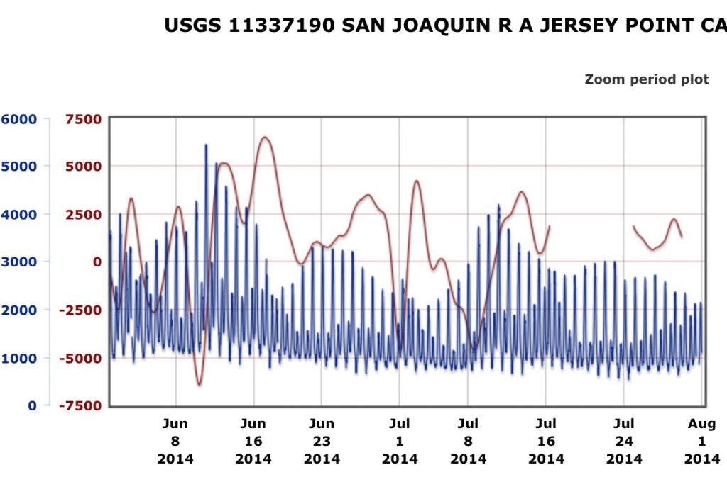
Figure 4. Salinity at Jersey Point in early summer 2016. X2 (EC 2700) has remained downstream.
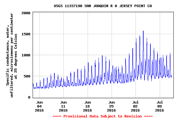
Figure 5. Tidally filtered flow at Jersey Point in early summer 2016. High negative flows are caused by South Delta exports during spring tides.
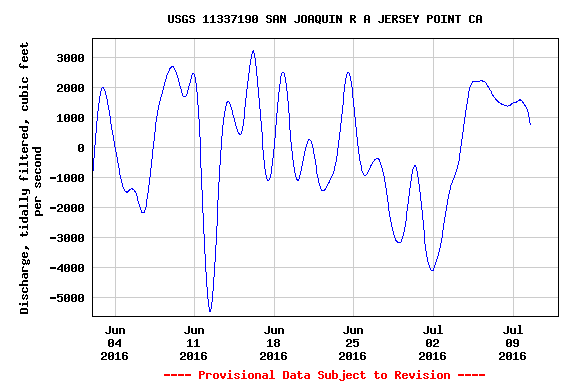
Figure 5. Tidally filtered flow at Jersey Point in early summer 2016. High negative flows are caused by South Delta exports during spring tides.
July 1 Smelt Update

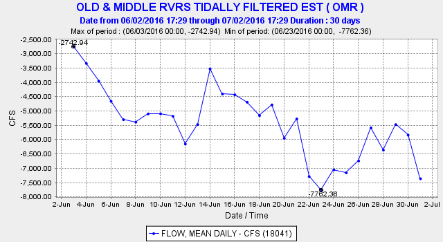
The Smelt Working Group packed its bags for the summer after its last meeting on May 31, just when it was most needed.  The water temperature in the South Delta had reached 77°F/25°C in the first week of June, forcing the Working Group to close shop, consistent with the biological opinion.  The 5000 cfs June south Delta export limit in the biological opinion also departed.  Exports soon rose above the earlier 3000 cfs limit, reaching nearly 7000 cfs later in June (Figure 1).

Figure 1

Figure 1. Old and Middle River net flows in June 2016. Negative flows generally correspond with export rates at the south Delta pumping plants. The limit in the Delta Smelt biological opinion is -5000 cfs for June, but the limit does not apply once the south Delta water temperature reaches 77°F/25°C.

The two June DFW 20-MM surveys showed that small numbers of Delta smelt remained in their normal northwest Delta nursery area (Figures 2 and 3) in slightly brackish, cooler (20-22°C) water. Still directly and indirectly vulnerable to the effects of exports, these smelt were sustained by a bare minimum of Delta outflows (7000-7500 cfs). What they needed and are still failing to receive are higher outflows to move them west to Suisun Bay.1 With exports soon to rise in July up to the full 11,400 cfs maximum capacity, and without further hope of higher outflow to the Bay, these last smelt may soon succumb to the rigors of the Delta as they did during the past four years of drought.

Instead of the prescribed standard of 6,500 cfs Delta outflow in July, an outflow of at least 8,000 cfs is necessary to protect the remaining smelt.

 Figure 2. Survey 7 of 20-MM Survey results for Delta smelt.


Figure 2. Survey 7 of 20-MM Survey results for Delta smelt.

Figure 3. Survey 8 of 20-MM Survey results for Delta smelt.

Figure 3. Survey 8 of 20-MM Survey results for Delta smelt.

June Protection Lost for Delta Smelt

In a May post and again in an early June post, I offered some hope for Delta smelt.  But the Smelt Biological Opinion and the Smelt Working Group failed the smelt once again.  The only protection afforded Delta smelt in June is the -5000 cfs Old-Middle River negative flow limit, which has the practical effect of limiting Delta exports to about 5000-6000 cfs.  Historically (from 1978-1994), D-1485 water quality standards limited June exports to 6000 cfs in order to protect Delta fish, but there are no June export limits in the existing D-1641 standards.

The last Smelt Working Group meeting was May 31.  The only biological opinion criterion left to manage, the -5000 cfs OMR limit, was gone because of a little known trigger in the opinion that dropped the OMR limit when the water temperature in the South Delta first reaches 25°C or 77°F (Figure 1).  The reasoning behind this trigger in the biological opinion was that exports would no longer hurt smelt because 25°C/77°F water temperatures would kill them anyway.  The problem with this logic is that exports can still pull smelt from their cooler nursery in the west and north Delta (Figures 2 and 3) into warm water killing zone in the central and south Delta.  Fortunately, export pumping in June 2016 was limited (Figure 4) by Reclamation’s holding back Shasta Reservoir storage releases to conserve cold-water for salmon.  Otherwise June exports and negative OMR flow would likely have been higher.

Reclamation has begun consulting with fishery agencies on a new biological opinion.  We can only hope that they improve protections for smelt and other Delta fish in spring and summer.  I suggest strong OMR restrictions any time the Delta Cross Channel in the far north Delta is closed, as this will help minimize (1) the draw of smelt from their nursery area and (2) the degradation of the Low Salinity Zone by south Delta exports.

Figure 1. Water temperature in Clifton Court Forebay in the South Delta in June 2016.

Figure 1. Water temperature in Clifton Court Forebay in the South Delta in June 2016.

Figure 2. Water temperature at Jersey Point in the west Delta in June 2016.

Figure 2. Water temperature at Jersey Point in the west Delta in June 2016.

Figure 3. Water temperature in the lower San Joaquin River at Three Mile Slough in June 2016.

Figure 3. Water temperature in the lower San Joaquin River at Three Mile Slough in June 2016.

Figure 4. June OMR flow. The Smelt Biological Opinion limit is for June is -5000 cfs, but that provision does not apply once south Delta water temperature reaches 25°C/77°F.

Figure 4. June OMR flow. The Smelt Biological Opinion limit is for June is -5000 cfs, but that provision does not apply once south Delta water temperature reaches 25°C/77°F.