Status of Smelt at end of 2015

Well the final tallies came in for the 2015 Fall Midwater Trawl Survey.  Indices for two smelt were again record lows as expected.  Not quite zero, but close.  The Smelt Working Group continues to track Endangered Species Act incidental take permit limits set in the 2008 federal biological opinion based on South Delta salvage: December – No salvage, no concern, so pump like hell.

Delta Smelt

It hard to tell from Figure 1, but 2015 came in with an index of 7, compared to the record low 9 in 2014. No fanfare this year from CDFW as back when 2011 index came out.  No articles in the SacBee.  Just another nail in the coffin.

Graph Smelt Trawl

Figure 1. Delta Smelt Fall Midwater Trawl catch for September-December 1967-2015 (no survey in 74, 79). Yearly index is total catch of four monthly surveys.

Longfin Smelt

It is even harder to tell from Figure 2 that the index for Longfin Smelt came in at 3 compared to last year’s record low of 16.

Graph of Longfin

Figure 2. Longfin Smelt Fall Midwater Trawl catch for September-December 1967-2015 (no survey in 74, 79). Yearly index is total catch of four monthly surveys.

Smelt Working Group

The Smelt Working Group met weekly in December after a 6 month hiatus.1  A couple of the low points:

“The WY 2016 adult Delta Smelt incidental take (IT) is 56, as is stated in the Service’s December 23, 2015 memo to the Bureau of Reclamation. The method to calculate the IT is that which is described on p 386 of the 2008 BiOp, with a correction (as discussed in the memo). The alternative approach that the Service presented to the 2015 independent review panel at the Long-term Operation Biological Opinions annual science review will be piloted this year.”  Thus the Working Group continues to use the old take limits from 2008 and has adopted the new more liberal method of calculation.  Given the remnant population level, allowing the take of  56 Delta smelt in salvage is indefensible.  For every fish taken in salvage, a hundred are lost in Clifton Court Forebay.

“The Working Group reviewed Delta Smelt distribution and salvage data, and current Delta conditions and provided no recommendation as yet for a change in water operations for either Delta Smelt or Longfin Smelt. However, members of the Working Group did conclude that entrainment risk is increasing and the group will meet again December 30 to further discuss a potential recommendation to the Service.”  Indeed, Delta Smelt had been detected in the central Delta at Jersey Point and Prisoners Point, and exports had increased from 800 to 6700 cfs.  Yet the Working Group prescribed no change in water operations. 

The Smelt Working Group planned to meet on December 30.  I cannot wait to see their notes from that meeting.

Cease and Desist DWR! – January 7, 2016

DWR – It just started raining and you already ramped up Delta exports again despite all the salt water and the risks to endangered Winter Run salmon and Delta Smelt. I recently suggested “Whoa,”1 as did Smelt Working Group. At least wait until the runoff from the storm hits the Delta.

The Smelt Working Group concluded on December 30: “The Working Group reviewed Delta Smelt distribution conditions. The working group concluded that entrainment risk has increased. This is based on fish distribution combined with increased water exports, but the group provided no recommendation for a change in water export reduction for either Delta Smelt or Longfin Smelt. This decision was based on the projected decrease in OMR flows from -5600cfs today to -2100cfs on Monday, 1/4. The group will be monitoring conditions closely over the next several days.” But no sooner had January 4 arrived than exports jumped sharply to even higher than the late December level (Figure 1), despite all the early warning signals brought up by the Working Group2.

Graph of Clifron Court Exports

Figure 1. State Water Project Delta exports at Clifton Court Forebay in past month.

The higher exports, in combination with spring tides, have pushed the Low Salinity Zone further east and south into the Delta (Figure 2). (Note: the ten-day charts readily depict recent increased salinity.)

Aerial map of salinity in Delta

Figure 2. Aerial photo with salinity levels (charts of EC), freshwater inflow (blue arrow), negative net inflows of brackish water (red arrows), and route taken by juvenile Winter Run salmon (yellow arrows). Clifton Court at bottom center.

Perhaps more ominous is the increase in salvage of Winter Run salmon (Figures 3 and 4). Twenty-seven were salvaged on 1/6. Given poor salvage efficiency (near 10 % in forebay alone) and the likely presence of many Winter Run trapped in the central and south Delta, as well as the desperate state of the Winter Run population, this is no time to be increasing exports. Where is the Salmon Working Group? This is serious “take”; authorized or not, NMFS should be doing something.

Graph of Salvage of Winter Run

Figure 3. Salvage of Winter Run at south Delta fish facilities. (Missing from this graph is 1/6 salvage that is depicted in Figure 4.) Source: http://www.dfg.ca.gov/delta/apps/salvage/SalvageExportChart.aspx?Species=1&SampleDate=1%2f2%2f2016&Facility=1

Table showing the Salvage of Winter Run

Figure 4. Salvage of Winter Run salmon at south Delta fish facilities 1/1-1/6 2016. Source: http://www.usbr.gov/mp/cvo/vungvari/salmondly.pdf

Whoa on the Delta Exports DWR

The California Department of Water Resources (DWR) and the US Bureau of Reclamation (USBR) recently raised south Delta exports from 800 cfs (12/15) to 6,700 cfs (12/29). Delta outflow of freshwater has declined from 27,000 cfs (12/25) to 5,300 cfs (12/29) in just four days. Though these conditions are allowed in Delta standards, the standards must be changed.

Under these conditions, with the Delta Cross Channel gates closed (per standards), water is pulled from the central and west Delta toward the south Delta export pumps (Figure 1). The problem is that remnants of the Delta smelt population have moved into the west and central Delta on their annual winter spawning migration, as shown in early warning surveys at Jersey Point (Figure 2). Negative net flows (Figures 3-6) draw fish to the pumps and disrupt the salinity field and Low Salinity Zone. Exports also continue to take brackish water (Figure 7) – not good for fish, crops, or humans. They also take juvenile salmon emigrating through the Delta (Figure 8).

Map of Delta Flows Dec 2015

Figure 1. Delta net flow patterns in late December 2015 – positive (blue arrow) and negative (red arrows).

Graph of False River Flows

Figure 3. False River (middle left red arrow in Figure 1) net flows have turned negative with lower Delta outflow and higher exports.

Graph of Three Mile Slough flows

Figure 4. Three Mile Slough (top left red arrow in Figure 1) net flows have turned sharply negative with higher exports.

Graph of Jersey Point flows

Figure 5. Jersey Point (left end of middle left arrow in Figure 1) net flows have turned negative with higher exports.

Graph of Old and Middle River Flows


Figure 6. Net flow in Old and Middle Rivers in south Delta (large lower right arrow in Figure 1) has turned sharply negative with higher exports.

Graph of EC at Clifton Court

Figure 7. Salinity levels (EC) in Clifton Court Forebay in December 2015.

Graph of Chinook and Exports

Figure 8. Salvage of Chinook salmon and export rate at Clifton Court Forebay in December 2015. Many of these salmon are likely endangered Winter Run and Spring Run.

Fremont Weir Fish Passage Update

The Fremont Weir fish passage improvements at the upper end of the Yolo Bypass (see previous posts for details1) are mandated in the National Marine Fisheries Service’s Central Valley Project and State Water Project joint biological opinion (2009 OCAP BO). The OCAP BO that allows limited take of endangered salmon, steelhead, and sturgeon for the wide array of water projects’ features (i.e. dams and water diversions), provided various improvements are made.

So far, as of the beginning of 2016 there have been no improvements or fixes at Fremont Weir, just more planning and discussion. Meanwhile, CDFW rescued hundreds of stranded salmon in the upper Bypass this fall. There has been no rescue of sturgeon since the Fremont Weir and Tisdale Weir rescue efforts in April 2011, when 24 endangered Green Sturgeon were rescued and radio tagged (21 eventually returned to the Pacific Ocean after migrating to spawning grounds in the upper Sacramento River2). Because of the drought, there have been no river flood flows over Fremont Weir into the Bypass since the April 2011 event. (Overflow of the Tisdale Weir into the Sutter Bypass did occur in Dec 2012 and Jan 2013.). However, salmon and sturgeon continue to be attracted to the Bypass by flows from local sources and to become stranded at the upper end of the Bypass.

“Fixes” under consideration for Fremont Weir include changes that would allow the Sacramento River to flood parts of the bypass at lower flows. The amount of water that might be diverted to the Yolo Bypass from the Sacramento River through prospective changes to the weir ranges from several hundred cfs to 6000 cfs. The larger end of the range of flows would be designed to provide for Bypass rearing of young salmon that would pass along with the water from the river to the Bypass. There is little doubt that young salmon do well in the over 40 miles of floodway habitats of the Bypass. The Delta also benefits from flow through the Bypass because of enhanced biological productivity.

It will take years to plan and implement such large sized enhancements in the Bypass. But an immediate solution to the adult salmon and sturgeon passage problem at Fremont Weir is not that complicated or contingent on other actions. OCAP BO Action 1.7– a Fremont Weir Ladder Project (reproduced below, with a deadline that is 5 years past) – should be implemented now


OCAP 

Action I.7. Reduce Migratory Delays and Loss of Salmon, Steelhead, and Sturgeon at Fremont Weir and Other Structures in the Yolo Bypass

Objective: Reduce migratory delays and loss of adult and juvenile winter-run, spring-run, CV steelhead and Southern DPS of green sturgeon at Fremont Weir and other structures in the Yolo Bypass.

Description of Action: By December 31, 2011, as part of the plan described in Action I.6.1, Reclamation and/or DWR shall submit a plan to NMFS to provide for high quality, reliable migratory passage for Sacramento Basin adult and juvenile anadromous fishes through the Yolo Bypass. By June 30, 2012, Reclamation and/or DWR shall obtain NMFS concurrence and, to the maximum extent of their authorities, and in cooperation with other agencies and funding sources, begin implementation of the plan, including any physical modifications. By September 30, 2009, Reclamation shall request in writing that the Corps take necessary steps to alter Fremont Weir and/or any other facilities or operations requirements of the Sacramento River Flood Control Project or Yolo Bypass facility in order to provide fish passage and shall offer to enter into a Memorandum of Understanding, interagency agreement, or other similar mechanism, to provide technical assistance and funding for the necessary work. By June 30, 2010, Reclamation shall provide a written report to NMFS on the status of its efforts to complete this action, in cooperation with the Corps, including milestones and timelines to complete passage improvements.

Rationale: The Yolo Bypass and Fremont Weir has been a documented source of migratory delay to, and loss of, adult winter-run, spring-run, CV steelhead and Southern DPS of green sturgeon. The existing fish passage structure is inadequate to allow normal passage at most operational levels of the Sacramento River. The project agencies must work with the Corps, which owns and operates Fremont Weir, to achieve improvements for fish. Other structures within the Yolo Bypass, such as the toe drain, Lisbon Weir, and irrigation dams in the northern end of the Tule Canal, also can impede migration of adult anadromous fish.

Additionally, stranding of juvenile salmonids and sturgeon has been reported in the Yolo Bypass in scoured areas behind the weir and in other areas. This action offsets unavoidable project effects on adult migration and minimizes the direct losses from flood management activities associated with operations.


Photo of Fremont Weir Fish Ladder

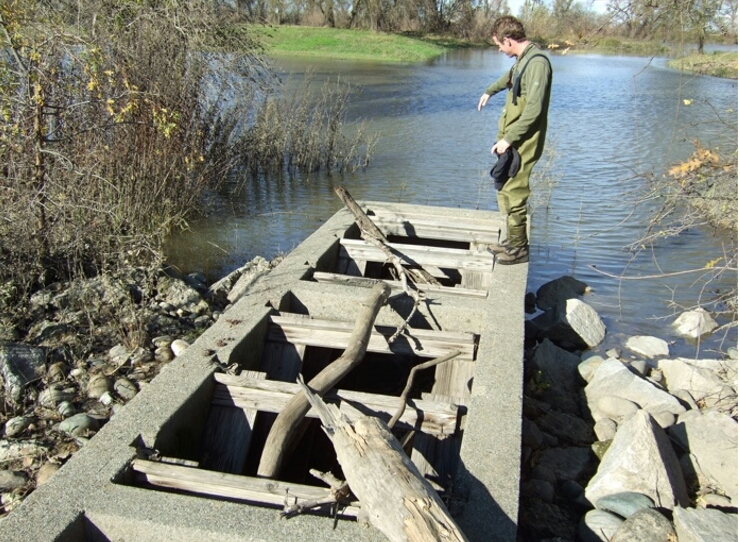
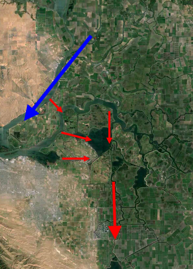
Fremont Weir Fish Ladder (Looking North towards flooded Sacramento River)

Fremont Weir Ladder Project

Fremont Weir Fish Ladder Replacement. “The existing Fremont Weir Denil fish ladder will be removed and replaced with new salmonid passage facilities designed to allow for the effective passage of adult salmonids and sturgeon from the Yolo Bypass past the Fremont Weir and into the Sacramento River when the river overtops the weir. Specific design criteria of the ladder have not yet been determined. This facility will incorporate monitoring technologies to allow for collection of information to evaluate its efficacy at passing adult fishes.” From Draft BDCP CM 2 Yolo Bypass Fishery Enhancement, October 5, 2010.

The 2010 proposal cited above would have been insufficient, because any prospective fish passage improvement would have been limited to conditions when the weir would overtop (river elevation 33.5’). Present planning efforts are looking at options that provide flows and passage at river elevations from 14’ to 22’. The deeper the project goes, the more often passage can be provided. Elevation 14’ is likely the limit: otherwise water could flow in reverse (from the Bypass through the weir to the river). A 14’ elevation would allow passage in most dry years when such action is most needed. But even in a wet year overflow like 2011, a 14’ elevation would relieve Bypass stranding potential by increasing the passage window by 20%, and by offering better through-opening conditions for passage.

Options:

  1. Dig and line channel to river from existing 30-ft ele down to 14/15-ft ele.
  2. Rebuild existing 4-ft-wide, 4-ft-deep ladder from existing 33-ft top ele and 28-30 ft ele bottom, to 8-20 ft wide, 8-15 ft deep slot or open box-culvert weir.
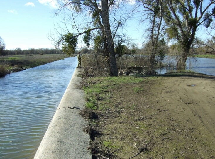
  3. Dig and line 10-ft-wide channel from weir apron down into Bypass to large pond about 50 yards distance. Bottom of channel should be about 14-ft ele through weir apron (it is presently at 28-ft ele). Bypass pond and Tule Canal downstream of weir (top center in photo below) is about 15-20-ft surface ele, thus channel to pond may have to incorporate step-pools. Channel enhancements may also be required between pond and Tule Canal.
  4. The pond should be filled so fish do not become stranded
Photo on wier

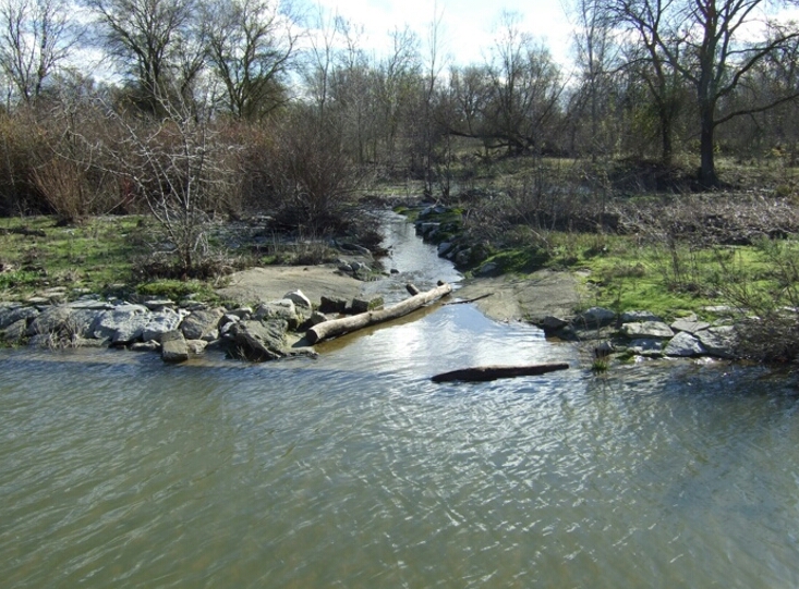
Photo above looking South from top of weir toward target pond

Photo of fish ladder

Ladder in center of photo. Bypass and apron to the left; River to the right (100 Yds).

  1. http://calsport.org/fisheriesblog/?p=497; http://calsport.org/fisheriesblog/?p=421
  2. Thomas, M. J., and others. 2013.  Stranding of Spawning Run Green Sturgeon in the Sacramento River: Post-Rescue Movements and Potential Population-Level Effects.  North American Journal of Fisheries Management 33:287–297.  ISSN: 0275-5947 print / 1548-8675 online. DOI: 10.1080/02755947.2012.75820.