Bay-Delta Spring Bloom Dissipates

In a May 17 post I discussed the occurrence of a rare spring Bay-Delta plankton bloom.  The bloom coincided with moderate Delta inflow and outflow in the present “normal” water year combined with a pulse of Delta inflow from the San Joaquin River.  The bloom and associated conditions likely benefitted smelt, salmon, striped bass, and other Bay-Delta fishes by providing cover (turbidity) and food for young fish.

The bloom has now dissipated in the Delta and Suisun Bay (Figures 1-3).  In contrast, the bloom has continued to intensify in the San Joaquin River upstream of the Delta (Figures 4 and 5).  The dissipation of the bloom coincided with the cessation of the San Joaquin pulse flow (2500-3500 cfs from April 18-May 15) combined with Delta inflow and outflow that is increasingly dominated by low turbidity, low nutrient water from the Sacramento River (Figure 6), mainly from high seasonal storage releases from Oroville (Feather River) and Folsom (American River) reservoirs.  In addition, with total South Delta exports now between 2000-3000 cfs, most if not all of the remaining turbid, high nutrient San Joaquin bloom water is being exported before it reaches the central Delta.

This pattern of Delta hydrology in a “normal” Sacramento River water year and a “dry” San Joaquin River water year shows the importance of the nutrient-laden San Joaquin water in the overall productivity of the Bay-Delta estuary.

Figure 1. Chlorophyll concentration May 12-27, 2016 in the lower San Joaquin River channel of the Delta east of Antioch near Sherman Island. Concentrations above 10 micrograms per liter of water are considered indicative of high phytoplankton production – a “bloom”. Source: CDEC.

Figure 1. Chlorophyll concentration May 12-27, 2016 in the lower San Joaquin River channel of the Delta east of Antioch near Sherman Island. Concentrations above 10 micrograms per liter of water are considered indicative of high phytoplankton production – a “bloom”. Source: CDEC.

Figure 2. Chlorophyll concentration April 27-May 25, 2016 in the lower Sacramento River channel of the Delta north of Antioch adjacent to Sherman Island. Concentrations above 10 micrograms per liter of water are considered indicative of high phytoplankton production – a “bloom”.

Figure 2. Chlorophyll concentration April 27-May 25, 2016 in the lower Sacramento River channel of the Delta north of Antioch adjacent to Sherman Island. Concentrations above 10 micrograms per liter of water are considered indicative of high phytoplankton production – a “bloom”.


Graph of Chlorophyll concentration April 28-May 27, 2016 in eastern Suisun Bay at Chipps Island near Pittsburg, CA 

Figure 3. Chlorophyll concentration April 28-May 27, 2016 in eastern Suisun Bay at Chipps Island near Pittsburg, CA. Concentrations above 10 micrograms per liter of water are considered indicative of high phytoplankton production – a “bloom”.

Figure 4. Chlorophyll concentration April 28-May 27, 2016 in San Joaquin River upstream of the Delta at Mossdale Bridge.

Figure 4. Chlorophyll concentration April 28-May 27, 2016 in San Joaquin River upstream of the Delta at Mossdale Bridge.

Figure 5. Chlorophyll concentration April 28-May 27, 2016 in San Joaquin River upstream of the Delta at Vernalis.

Figure 5. Chlorophyll concentration April 28-May 27, 2016 in San Joaquin River upstream of the Delta at Vernalis.

Figure 6. The relative proportions of Delta inflow from the Sacramento and San Joaquin rivers in May 2016. The higher proportion of San Joaquin inflow in the first half of May was from a flow pulse. Higher Sacrament River flows after early May are from increased storage releases from Oroville and Folsom reservoirs.

Figure 6. The relative proportions of Delta inflow from the Sacramento and San Joaquin rivers in May 2016. The higher proportion of San Joaquin inflow in the first half of May was from a flow pulse. Higher Sacrament River flows after early May are from increased storage releases from Oroville and Folsom reservoirs.

Are Striped Bass about to make a comeback?

Unlike most of the Central Valley native fishes including salmon and smelt, striped bass have an inherent natural advantage or resilience: they are long-lived, have ten or more spawning year-classes in any spawning year, and produce a thousand times more eggs per female. This advantage has come into play after a decade of drought: in the spring of 2016, there are optimal spawning and early rearing conditions for striped bass.

The late April 20-mm Survey results indicate a possible strong year class for stripers compared to recent years. The distribution of larvae in late April 2016 (Figure 1) is the product of moderate normal year Delta outflow with low Delta exports. The 2016 distribution is a dramatic improvement over the critically dry year 2015 (Figure 2), the drought-year 2009 (Figure 3), and also the normal year 2010 (Figure 4).

Normal water year spring Delta outflows that place the Low-Salinity-Zone westward in Suisun Bay, combined with a strong spring plankton bloom, bode well for the growth and survival of young stripers. In contrast, conditions were poor in 2015, when young stripers were confined to the Delta under low Delta outflows and low productivity, and were subject to Delta exports and diversions (Figure 2). Chances of a comeback in the fall-index (Figure 5) remain to be seen, given the lack of summer Delta protections since 1995 under the existing Delta Water Quality Control Plan. Expected high summer exports and low Delta outflows, such as those in normal water year 2010 (the record low fall-index year), may yet preclude a comeback.

Figure 1. Striped bass larvae density distribution in 20-mm Survey #4, Apr 25-28, 2016.

Figure 1. Striped bass larvae density distribution in 20-mm Survey #4, Apr 25-28, 2016.

Figure 2. Striped bass larvae density distribution in 20-mm Survey #4, Apr 27-30, 2015.

Figure 2. Striped bass larvae density distribution in 20-mm Survey #4, Apr 27-30, 2015.

Figure 3. Striped bass larvae density distribution in 20-mm Survey #4, Apr 20-24, 2009.

Figure 3. Striped bass larvae density distribution in 20-mm Survey #4, Apr 20-24, 2009.

Figure 4. Striped bass larvae density distribution in 20-mm Survey #4, Apr 26-29, 2010.

Figure 4. Striped bass larvae density distribution in 20-mm Survey #4, Apr 26-29, 2010.

Figure 5. Striped bass fall index of young striped bass 1967-2013. Not shown are the near record low indices in 2014 and 2015 (59 and 52, respectively).

Figure 5. Striped bass fall index of young striped bass 1967-2013. Not shown are the near record low indices in 2014 and 2015 (59 and 52, respectively).

Puget Sound Salmon Fishing – Closed Until Further Notice

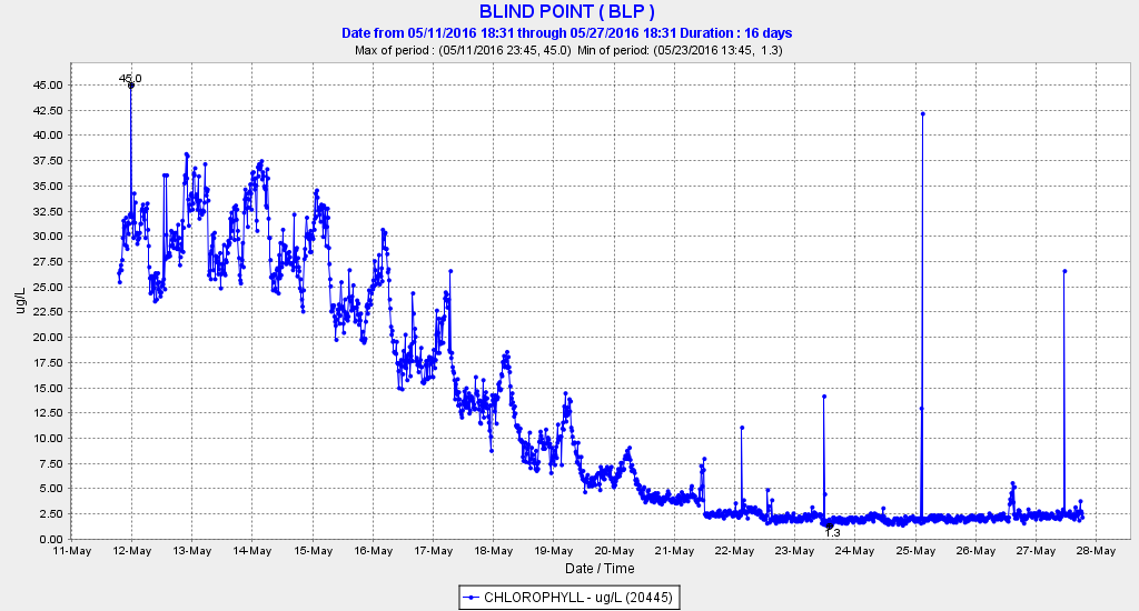
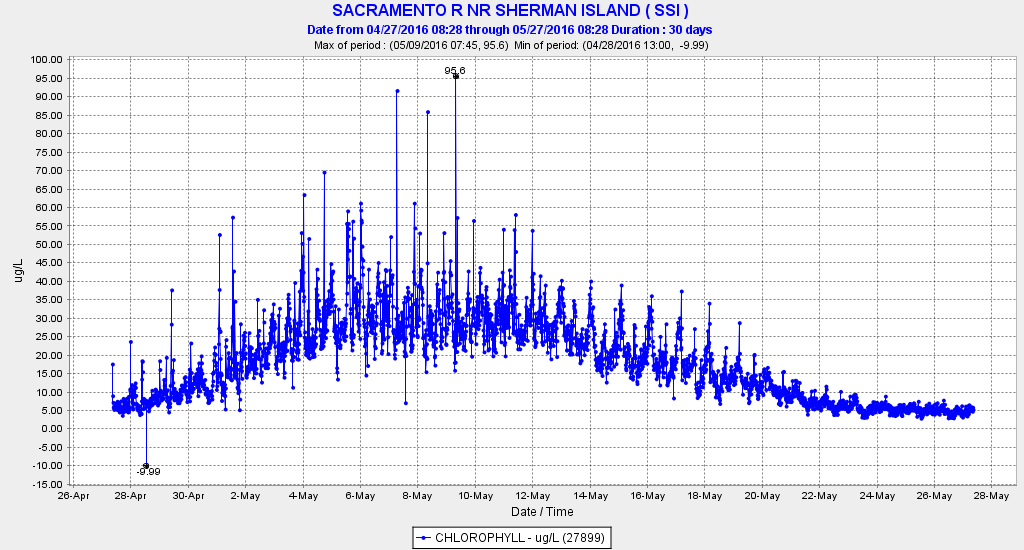
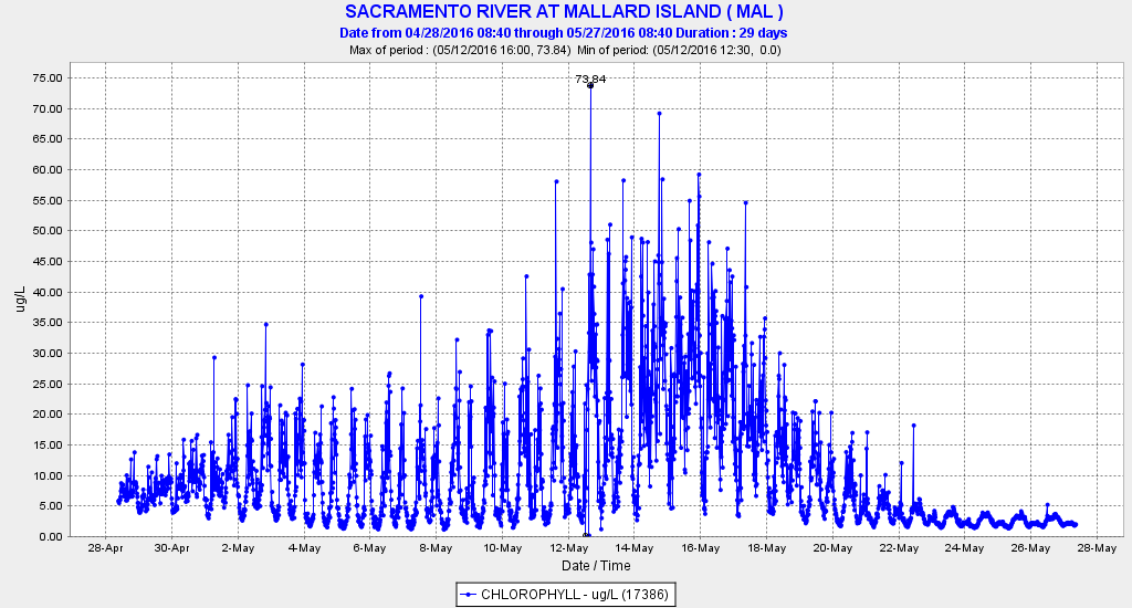
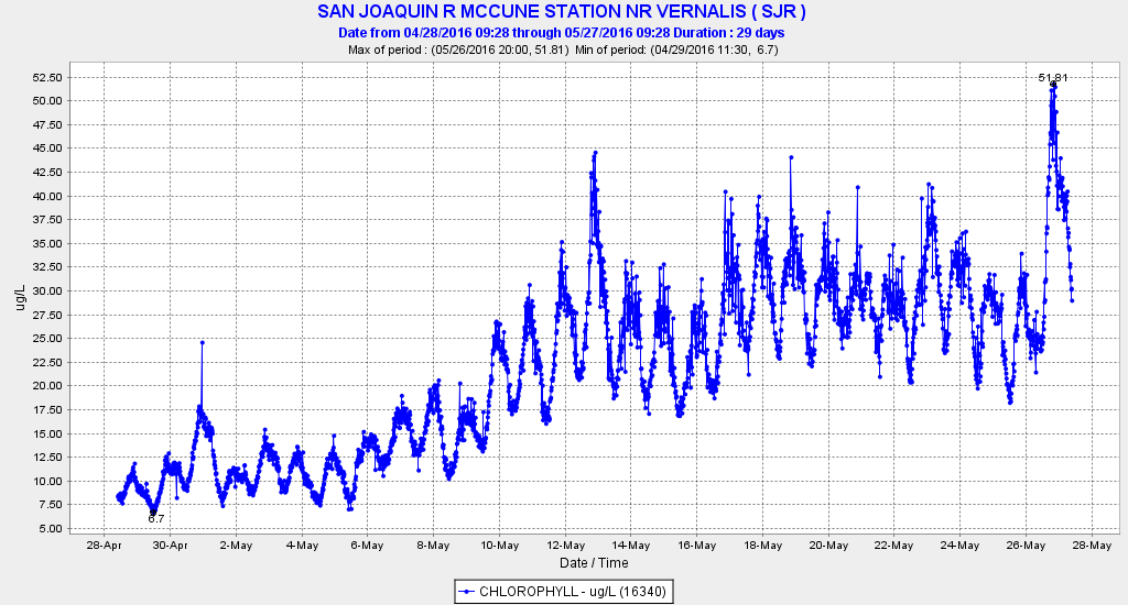
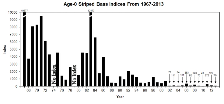
For the first time in almost 30 years, there may be no salmon fishing in Puget Sound in 2016.  Several reasons are apparent for this situation.  First, the Coho salmon returns this year are projected to be very poor as a result of unfavorable ocean conditions and the drought in many Washington streams that occurred last year.  The projected returns of adult Coho salmon are very low (particularly for non-hatchery or wild fish that are listed as “threatened” under the Endangered Species Act).  There are also concerns about low returns of wild Chinook salmon.

Seasons in Washington are set on an annual basis by the co-managers of the resource.  These co-managers are the Washington Department of Fisheries (WDFW), which represents the non-Indian sport and commercial fishermen on one side and the Indian tribes in Puget Sound, which represent the interests of about 20 different tribes.  This co-management approach evolved after the Judge Boldt decision in 1974 that established the 50/50 split on harvest between the two entities.  Initially, the court system set regulations, but the co-management approach evolved shortly thereafter to let the resource managers set the seasons rather than the court system.

Under the co-management process, seasons have been negotiated and set in the early spring each year.  The co-managers meet, present their positions based on the information each has (including models of the fish returns), discussions are conducted, and the seasons are mutually agreed upon.  These negotiated regulations are then forwarded to the North Pacific Fisheries Management Council, which then provides final review and approval.  Then the National Oceanic and Atmospheric Administration (NOAA) issues permits for the seasons.

This process has worked in finalizing the seasons, until this year.  When the co-managers first met in late April, the WDFW proposed a restricted season that would allow a “selective fishery” for hatchery Chinook salmon along with possible fishing for hatchery Coho.  (Hatchery fish are marked by the removal of their adipose fin).  The Tribes, however, proposed a total closure for all salmon fishing in Puget Sound to protect wild Coho and all Chinook salmon.

In the first two meetings, the co-managers showed no movement toward an agreement on the Puget Sound situation.  (However, agreement was reached on seasons for the Columbia River and the outer coast of Washington and included severely restricted quotas accompanied with selective fishing for marked fish.)   WDFW walked out of the meetings regarding Puget Sound.   Although the two sides have been in further discussion, as of this date – May 19 – no agreement has been made.

To further complicate the situation, WDFW and the Tribes have decided to submit separate proposals to the NOAA in order to obtain separate permits for their proposed seasons.  (NOAA issues the final permits as part of the Endangered Species Act).  NOAA’s response to this has been “WDFW and the Tribes must come to agreement with NOAA offering assistance to the process, but it will not make a decision on the proposals”.  To process these permit submittals, NOAA has estimated that the Tribal proposal (which does include some limited fishing in some isolated situations) could possibly be processed in time for this co-manager’s reduced seasons to go forward.  However, NOAA has indicated that the WDFW proposal could be lengthy (due to the need for public review and comment) and likely could not be processed this year.

In general, the salmon seasons for both Tribal and non-Tribal fishermen in Puget Sound have been severely reduced over the past several decades as a result of lower returns resulting from habitat losses, dramatic increases in predators (birds, seals, sea lions, etc.), and the 50/50 split with the Indian Tribes.  If no agreement can be reached in the next few weeks, there will be no sport/commercial fishing for Puget Sound salmon in 2016.  This outcome will likely result in major regional economic impacts (a sporting goods store has already closed).  There are about 200,000 salmon anglers that have held licenses in the Puget Sound region.  If the closures continue, these fishermen would have no opportunity to fish for salmon in the Puget Sound basin – only ardent fishermen will likely travel to the coastal ports of Washington or the Columbia River to participate in their sport.

In a related development, the WDFW has closed all fishing (all species) in all Puget Sound streams, rivers, and lakes accessible to Coho or Chinook salmon.  These closures include large lakes such as Lake Washington where there is a popular fishery for bass and other warm water species.  In addition, the summer-run steelhead season, another very popular fishery in many Puget Sound streams, usually opens in early June (which is only a few weeks from this date).  This fishery is also destined to remain closed if no agreement can be reached.

Although NOAA has been the Federal agency that was presumed to issue the final permits for the Tribal and the non-Tribal sport/commercial fisheries, much to the surprise of many fishermen and non-fishermen, the Bureau of Indian Affairs approved a separate permit for a limited Tribal fishery for spring Chinook salmon in the Skagit River (a major tributary of Puget Sound).  The fishery was conducted and resulted in several demonstrations by non-Tribal fishermen, both on the Skagit River and at the state capitol in Olympia.

Most of the Tribes favor some type of agreement.  However, two of the Tribes do not favor any agreement except no fishing.  This has complicated the entire negotiation process because all Tribes in the co-management process must agree to the final regulations before they can be submitted for approval.

As a result of this convoluted process, the likelihood of a salmon fishery in Puget Sound this year is clearly in doubt.  Many of the non-Tribal fishermen believe the current negotiation process needs to be overhauled.

USBR – Increase Shasta Cold Water Releases

Water Year 2016 on the Sacramento River has been designated a “Below Normal” year.  Water Year 2010 was also a Below Normal year.  Both years followed multiyear droughts.  In both years, Shasta Reservoir was nearly full at the end of April (2010 was 4.4 maf; 2016 was 4.2 maf).  In early May 2010, Keswick releases were 7500 cfs, and release water temperatures were 50-52°F.  In early May 2016, Keswick releases have been 5200-6200 cfs, and release water temperatures have been 53-55°F.

In April and May, 2010, water temperatures in the upper river remained below 56°F.  In contrast, the warmer, lower flows in 2016 have led to excessively warm water temperatures in the upper Sacramento River.  Water temperatures have reached 60-62°F in the upper river (Figure 1), which are well above the prescribed water quality standard of 56°F necessary to protect spawning salmon and sturgeon.  Winter-run salmon began spawning in late April.  Green and white sturgeon spawn in May.

Figure 1. Water temperature in the upper Sacramento River below Shasta Reservoir in early May 2016. In contrast, water temperatures at these locations during early May 2010 were 56°F or lower.

Figure 1. Water temperature in the upper Sacramento River below Shasta Reservoir in early May 2016. In contrast, water temperatures at these locations during early May 2010 were 56°F or lower.

Reclamation’s CVP operations should strive to maintain the 56°F standard through the spring and summer, as prescribed in the Basin Plan and in the NMFS biological opinion for Shasta operations. This temperature can be achieved by increasing Shasta releases or by lowering the water temperature of releases using the temperature control tower/device (TCD) at the dam, or by a combination of these elements. In the last few days, Reclamation has increased releases and has added colder water, resulting in slightly colder Keswick releases (Figure 1). Reclamation has decreased the temperature of releases by opening one the six middle outlets of the Shasta Temperature Control Device (Figure 2). However, downstream temperatures remain high, because air temperatures and water diversions downstream are also increasing.

While there is some logic behind Reclamation’s decision to minimize reservoir releases to save Shasta storage, it is inappropriate to jeopardize endangered fish in the upper Sacramento River with excessively warm water this year, given the abundance of cold water in the reservoir. 1

With Shasta releases expected to increase soon to meet increasing irrigation demands, it will be imperative that water temperatures upstream of Red Bluff remain below 56°F to protect spawning salmon and sturgeon and their young into and through the summer.

The “official” temperature target and control point since April 15, 2016 have been 58°F at Redding (station CCR). In 2010, the target temperature was 56°F, and the control point was at Jellys Ferry (RM 267), 20 miles downstream of Redding. The State Board and NMFS should immediately change the target temperature to 56°F, and move the control point at least downstream to Jellys Ferry. Preferably, the compliance point should be further downstream at Red Bluff, to be in compliance with the NMFS biological opinion (56°F at Red Bluff – RM 243). The Basin Plan puts the compliance point further downstream still, (56°F at Hamilton City – RM 200). 2

Following catastrophic losses of winter-run in the Sacramento below Shasta during the past two years, it is imperative to meet the summer water temperature goals as prescribed in the NMFS biological opinion. The Shasta cold-water pool and storage available are more than adequate to meet these objectives.

Figure 2. Shasta Dam’s temperature control tower/device or TCD has multiple options for releasing water from the reservoir. One middle outlet was recently opened to reduce the temperature of the water released to the Sacramento River. (Source: USBR MidPacific Division)

Figure 2. Shasta Dam’s temperature control tower/device or TCD has multiple options for releasing water from the reservoir. One middle outlet was recently opened to reduce the temperature of the water released to the Sacramento River. (Source: USBR MidPacific Division)

  1. A disproportionate amount of Sacramento River Delta inflow this spring has come from Oroville Reservoir (Feather River) and Folsom Reservoir (American River) storage releases. Excessive use of Folsom storage to meet Bay-Delta needs could lead to loss of its cold-water pool this summer and greater mortality of over-summering juvenile salmon and steelhead in the American River.
  2. A plan for summer operations from Reclamation is due by May 15, 2016

Rare Bay-Delta Spring Bloom may benefit Smelt

A rare Bay-Delta spring plankton bloom in 2016 may benefit longfin and Delta smelt (and other fish).  The bloom (a condition in which chlorophyll concentrations consistently exceed 10 micrograms per liter of water) commenced in late April.  Geographically, it extended from Suisun Bay up into the Delta to Rio Vista on the Sacramento River and to near Stockton on the San Joaquin River (Figure 1).

Figure 1. Bay-Delta phytoplankton bloom late-April to mid-May 2016. Plots show chlorophyll concentrations at selected stations from mid-April to mid-May. Source: CDEC.

Figure 1. Bay-Delta phytoplankton bloom late-April to mid-May 2016. Plots show chlorophyll concentrations at selected stations from mid-April to mid-May. Source: CDEC.

The bloom coincided with a drop in previously high early spring Delta inflow and outflow, as well as with low exports and the implementation of San Joaquin River pulse flows.1 Delta outflows were moderate, relatively steady, and higher than in recent drought years, and consistent with a “normal“ year pattern (Figure 2). San Joaquin River pulse flows occurred after mid-April (Figure 3). The Low Salinity Zone or LSZ (0.5-6 ppt) was located in Suisun Bay. X2 (2 ppt) migrated with the tides from Honkers Bay (northwest of MAL) to Sherman Island (northeast of ANH) within eastern Suisun Bay. The head of the LSZ (500-1000 EC) and the bloom extended upstream to Rio Vista on high tides (Figures 4 and 5). Water quality standards (D-1641) that require 14-day average X2 to be at Chipps Island (MAL) or further west helped to ensure consistent Delta outflow.

Longfin smelt concentrated near X2 and may benefit from plankton bloom (Figure 6). Remaining Delta smelt may also benefit as they too concentrate near X2. Maintaining the LSZ and X2 in Suisun Bay is generally thought to promote Bay-Delta productivity and higher smelt survival. In the past four years of drought, the LSZ and X2 during spring and summer have generally been upstream of Suisun Bay, in the Delta.

Figure 2. Delta outflow mid-April to mid-May 2016. Source: CDEC.

Figure 2. Delta outflow mid-April to mid-May 2016. Source: CDEC.

Figure 3. San Joaquin River inflow to the Delta at Mossdale April-May 2016. Source: CDEC.

Figure 3. San Joaquin River inflow to the Delta at Mossdale April-May 2016. Source: CDEC.

Figure 4. Bottom salinity in Sacramento River several miles downstream of Rio Vista in early May 2016. Source: CDEC.

Figure 4. Bottom salinity in Sacramento River several miles downstream of Rio Vista in early May 2016. Source: CDEC.

Figure 5. Chlorophyll concentrations at Rio Vista in early May 2016. Source: CDEC

Figure 5. Chlorophyll concentrations at Rio Vista in early May 2016. Source: CDEC

Figure 6. Catch distribution of young Longfin smelt in late April 2016 along with extent of plankton bloom (red boundary). Smelt were concentrated (larger green dots) near X2 in central and eastern Suisun Bay. Source: CDFW 20-mm Survey.

Figure 6. Catch distribution of young Longfin smelt in late April 2016 along with extent of plankton bloom (red boundary). Smelt were concentrated (larger green dots) near X2 in central and eastern Suisun Bay. Source: CDFW 20-mm Survey.

  1. The bloom also occurred after a winter of moderate Yolo Bypass flood spills that may have contributed nutrients to fuel the bloom. Elevated Bypass flows continued through mid-April.