Low Flows – Deadly Water Temperatures

Low flows in the Sacramento River and Delta lead to deadly water temperatures for Central Valley salmon, steelhead, sturgeon, and smelt, including six state or federally listed endangered species. Water quality standards and operating requirements for the state and federal water projects should include new flow limits to protect fish.

Sacramento River

Salmon, steelhead, and sturgeon are subjected to deadly spring and summer water temperatures when lower Sacramento River flows fall below 5000 cfs as measured at Wilkins Slough (Figure 1). Low flows and high water temperatures lead to poor survival and increased predation, and block migrations of adult salmon.

Delta

Low flows through the lower Sacramento River channel in the Delta also lead to deadly water temperatures for salmon and smelt. When Delta inflow falls below 10,000 cfs, water temperatures become deadly for Delta Smelt (Figure 2) and salmon (Figure 3).

Figure 1. Daily average water temperature and river flow in the Sacramento River at Wilkins Slough (RM 125) 2007-2016. Water temperatures greater than 75°F are lethal to salmon and sturgeon, and block salmon migration. The water quality standard for the lower Sacramento River is a limit of 68°F. Temperatures above 68°F are stressful to salmon, sturgeon, and steelhead, and lead to increased risk of predation, lower survival, and poor reproductive success.

Figure 1. Daily average water temperature and river flow in the Sacramento River at Wilkins Slough (RM 125) 2007-2016. Water temperatures greater than 75°F are lethal to salmon and sturgeon, and block salmon migration. The water quality standard for the lower Sacramento River is a limit of 68°F. Temperatures above 68°F are stressful to salmon, sturgeon, and steelhead, and lead to increased risk of predation, lower survival, and poor reproductive success.

Figure 2. Daily average water temperature and river flow in lower Sacramento River near Freeport. Water temperatures greater than 73°F are lethal to smelt and block salmon migrations.

Figure 2. Daily average water temperature and river flow in lower Sacramento River near Freeport. Water temperatures greater than 73°F are lethal to smelt and block salmon migrations.

Figure 3. Daily average water temperature in the south Delta at Clifton Court 2009-2016. Water temperatures greater than 25°C (77°F) are lethal to salmon and smelt.

Figure 3. Daily average water temperature in the south Delta at Clifton Court 2009-2016. Water temperatures greater than 25°C (77°F) are lethal to salmon and smelt.

State Board: Increase Sacramento River Flow

The State Water Resources Control Board is responsible for enforcing water rights and the Sacramento River Basin Plan that protects beneficial uses including fish and water quality.1 The Basin Plan’s 68°F objective for the lower Sacramento River is clearly being violated right now because of low Sacramento River flows brought about by lower than normal Shasta releases and a 100 % allocation of water to Sacramento Valley water contractors. The State Board has jurisdiction over both of these factors through control of water rights. The State Board is about to review Reclamation’s Water Temperature Plan (WTP) for summer 2016, which calls for a 10,500 cfs release in July, several thousand cfs below normal, to conserve Shasta’s cold-water pool for salmon through the summer and fall. The WTP however has no provisions for cutting downstream water use. Thus, flows in the lower Sacramento River will be lower, with higher water temperatures that violate the Basin Plan. The flows must be raised at Wilkins Slough (RM 125) by either increasing Shasta releases or reducing water diversions, or a combination thereof.

The Basin Plan objective of 68°F is there to protect salmon and sturgeon migrating and rearing in the lower Sacramento River. Water temperatures above 68°F are stressful to the fish, affecting growth, survival, and subsequent reproduction. Present water temperatures in the lower river (Figure 1), caused in part by low flow (Figure 2), are lethal to salmon and sturgeon. In 2010 and 2012, water years similar to 2016, flows were higher and water temperatures were lower in early summer (Figures 3-6).

The State Board, in reviewing the WTP, must explicitly consider flows and water temperatures in the lower Sacramento River under its broader responsibilities to protect fish as prescribed in the Basin Plan and in various water rights orders.

 Figure 1. Water temperature of lower Sacramento River at Wilkins Slough (RM 125) in early summer 2016.


Figure 1. Water temperature of lower Sacramento River at Wilkins Slough (RM 125) in early summer 2016.

Figure 2. Sacramento River flow at Wilkins Slough (RM 125) in early summer 2016.

Figure 2. Sacramento River flow at Wilkins Slough (RM 125) in early summer 2016.

Figure 3. Water temperature of lower Sacramento River at Wilkins Slough (RM 125) in early summer 2010.

Figure 3. Water temperature of lower Sacramento River at Wilkins Slough (RM 125) in early summer 2010.

Figure 4. Sacramento River flow at Wilkins Slough (RM 125) in early summer 2010.

Figure 4. Sacramento River flow at Wilkins Slough (RM 125) in early summer 2010.

Figure 5. Water temperature of lower Sacramento River at Wilkins Slough (RM 125) in early summer 2012.

Figure 5. Water temperature of lower Sacramento River at Wilkins Slough (RM 125) in early summer 2012.

Figure 6. Sacramento River flow at Wilkins Slough (RM 125) in early summer 2012.

Figure 6. Sacramento River flow at Wilkins Slough (RM 125) in early summer 2012.

June Update and Possible Solution to 2016 Fish Woes

Over the past month I related water issues involving Delta and longfin smelt, striped bass, green and white sturgeon, and winter-run and spring-run salmon. All of these species need river flow and cooler water over the next several months. Shasta releases to the upper Sacramento River need to be cold, stable, and sufficient to sustain winter-run salmon eggs in the river near Redding and to sustain moderate flows and cooler water temperatures for 200 miles of river to protect sturgeon and other lifestages of salmon. Sufficient flows needs to pass through the Delta to keep the low salinity zone downstream of the Delta in the cool waters of eastern Suisun Bay, away from Delta exports.

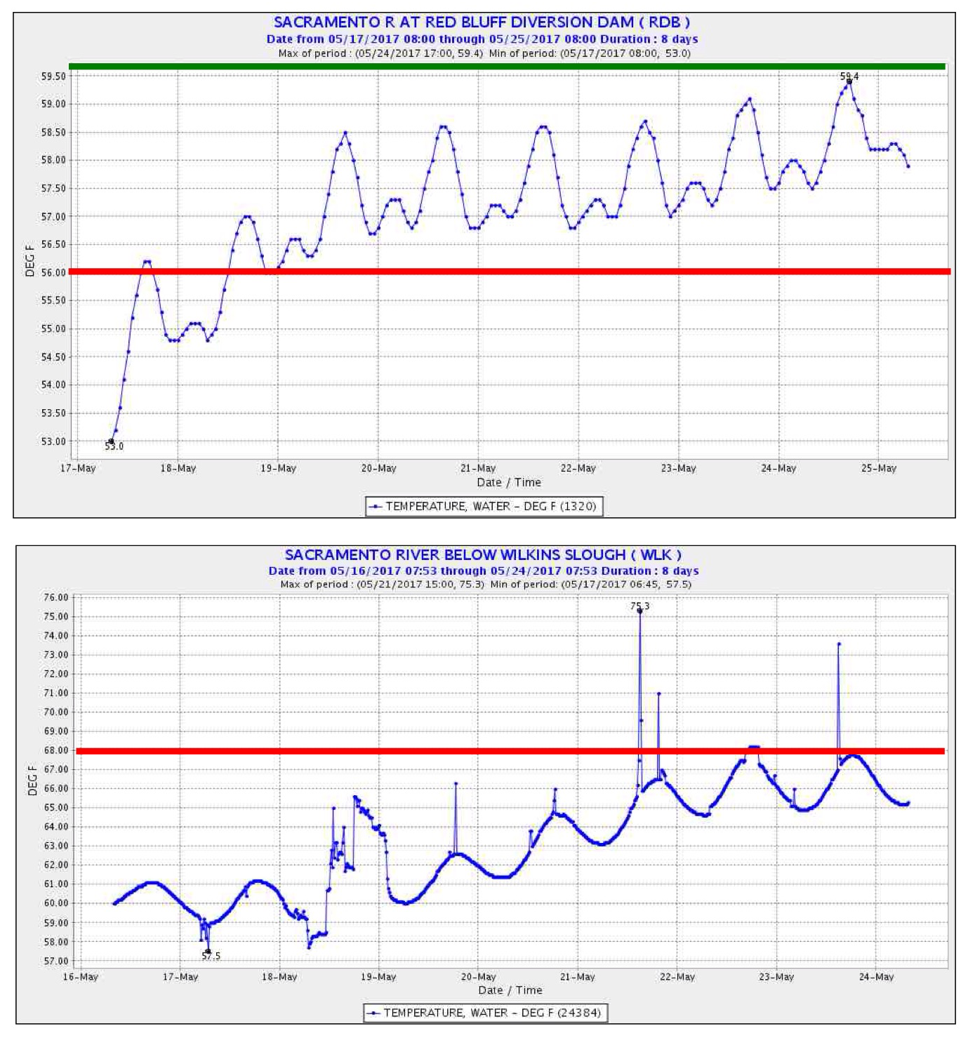
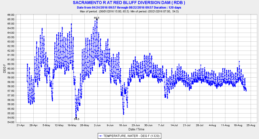
Shasta releases are now 8000 cfs, with Bend Bridge water temperature near the Red Bluff target of 56°F. In June and July of drought years 2012 and 2013, releases were 11,000-14,000 cfs. However, concern over carryover storage and sustaining cold-water releases through summer has led to a more conservative management strategy in 2016. The cold-water pool in Shasta Reservoir is being rationed to make it through the summer. Flows will rise over the next six weeks to 9,000 or 10,000 cfs to satisfy irrigation demands in the upper river.

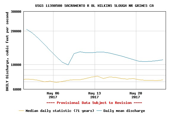
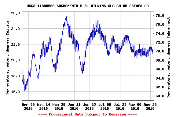
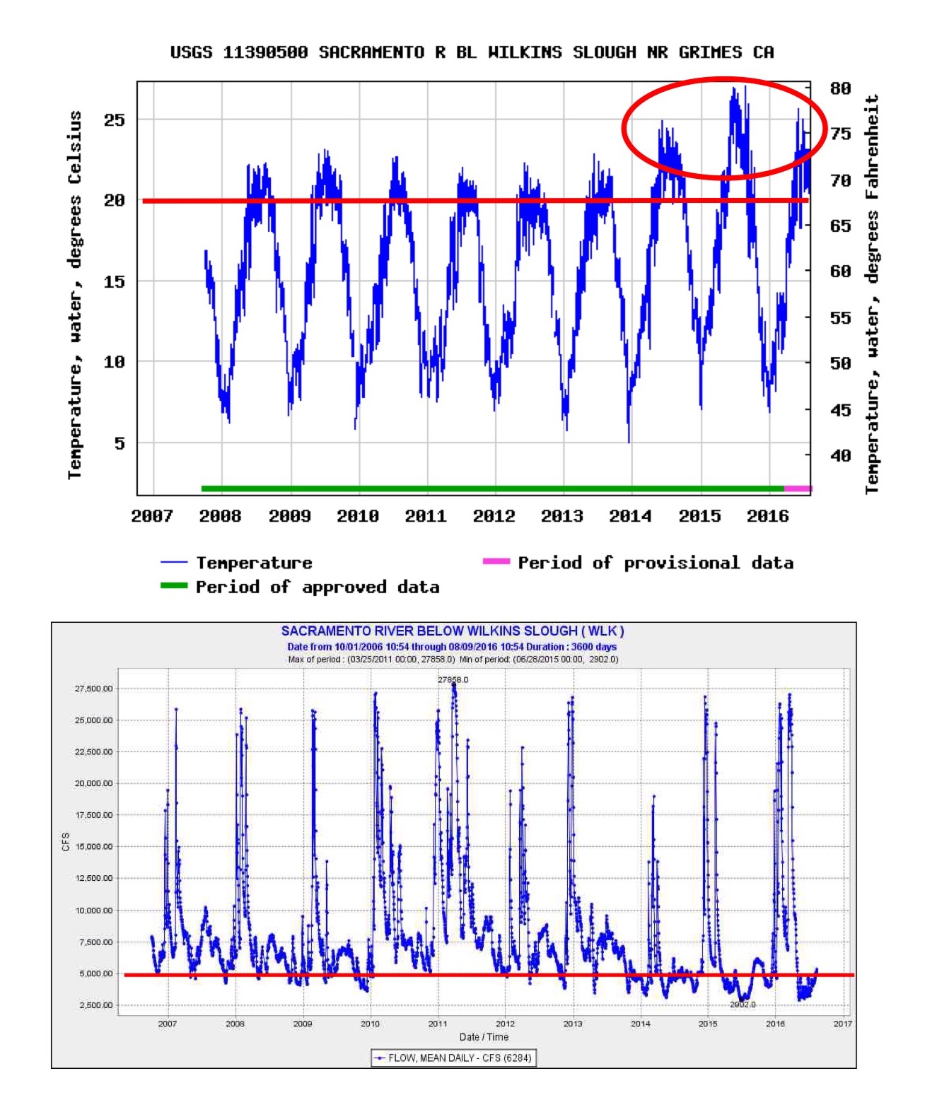
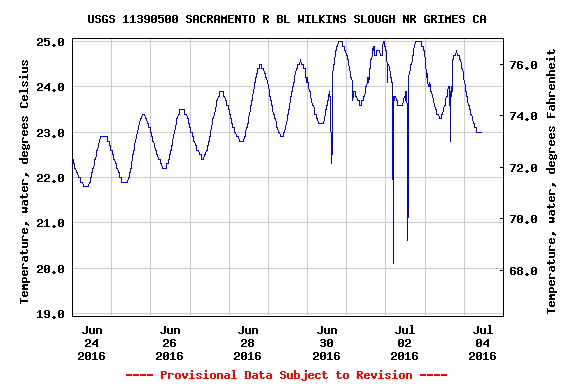
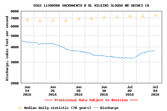
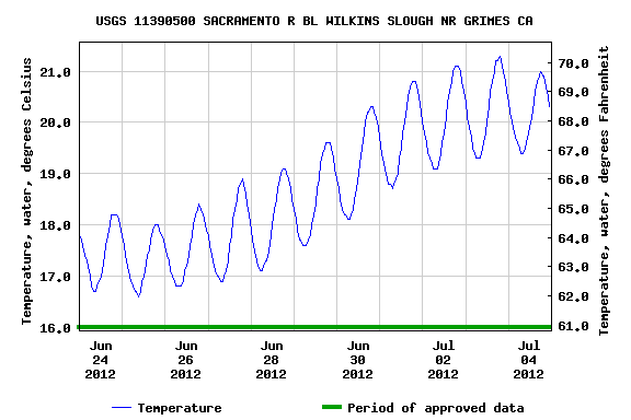
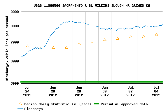
Flows in the lower Sacramento River at Wilkins Slough need to be greater than 5000 cfs in summer, if only to keep water temperature down closer to the Basin Plan’s 68°F. Flows are now 3000-4000 cfs, with water temperatures up to 75°F. In dry years 2012 and 2013, flows at Wilkins Slough were 6000-9000 cfs, and water temperatures were cooler, as some of Shasta’s storage was allocated for Delta export. This year’s management strategy to hold back Shasta releases will, if continued, keep both Wilkins Slough flows and Delta exports down.

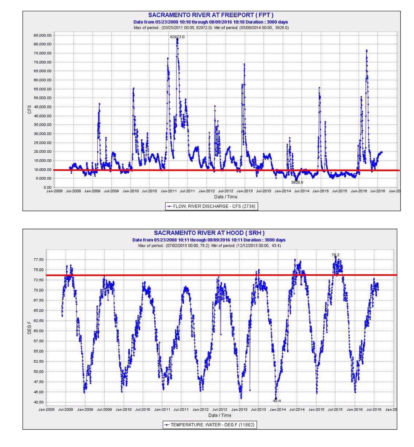
Delta outflows need to be sustained near 10,000 cfs to keep the low salinity zone and X2 (2 ppt salinity) near Collinsville in eastern Suisun Bay. However, July outflow to the Bay required by water quality standards will be only about 8000 cfs. To help save the last of the two smelt species, 10,000 cfs would be far better.

A reasonable solution is apparent: raise Shasta releases through most of the summer by 2000 cfs to 10,000-12,000 cfs and require that the extra release be passed down the river to and through the Delta. While such a management strategy would benefit the fish, it would decrease Shasta storage by 120,000 acre-ft of water per month. At present, Shasta is 90% full at 4.1 million acre-feet (the cold-water pool volume is about 2.4 maf). At 12,000 cfs, the total Shasta release would rise to 600,000 acre-feet per month, which is about the current total release from Oroville (Feather River) and Folsom (American River) reservoirs. NMFS and USBR have determined that a 10,000 cfs Shasta cold-water release can be sustained through the summer, while a 12,000 cfs release could be problematic. Protests would no doubt come from water users who would want the extra 2000 cfs. But note that of the 20,000 cfs being released today from the three main Sacramento Valley reservoirs, only 8000 cfs is reaching the Bay.1

This solution of raising total reservoir releases to 22,000-24,000 and Bay outflow to 10,000 cfs is reasonable to help the fish after four years of drought. In 2014-2015, water quality standards were drastically reduced, with catastrophic effects to fish. The continuing legacy of these catastrophic effects creates the urgency to do better in 2016.

If higher releases from Shasta become problematic for whatever reason, then some compromise should be achievable, noting that water deliveries of Shasta water are to be provided only after the needs of the fish are first considered, including conservation of Shasta’s cold-water pool through the summer and early fall (Water Rights Orders 90-05 and 92-02). Further, Central Valley water rights are provided via the Trinity River trans-basin diversion to Keswick Reservoir on the Sacramento River below Shasta Dam, but the Trinity supply is much in doubt because Trinity storage has failed to recover after the drought, unlike Shasta storage. A lack of Trinity supply this summer will further limit water available for irrigation in the Central Valley. Yet another constraint is whether the available storage in Oroville and Folsom reservoirs is able to satisfy Delta demands without compromising the needs of endangered fish in the Feather and American rivers.

Sorting out these conflicts and needs is the responsibility of the State Water Resources Control Board. The Board’s top priority should be the basic needs of the endangered salmon, sturgeon, and smelts of the Central Valley. At minimum, the Board should require the following conditions this summer:

  1. Below Shasta – Stable flows of 9,000 to 10,000 cfs and 56°F average daily water temperatures near Red Bluff (Jellys Ferry or Bend Bridge).
  2. Lower Sacramento River – minimum 5000 cfs at Wilkins Slough (RM 125 on the Sacramento River)
  3. Delta Outflow – 9,000 cfs in July, 5,000 cfs in August, and 4,000 cfs in September.
  1.  A further complication is that South Delta export criteria allow an increase from 35% of inflow to 65% starting July 1.  Exports in June are limited to 5000 cfs.  In July, exports can be raised to 65% of inflow, but only if outflow is kept at 8000 cfs.  Delta ag diversions are also near 4000 cfs.  Thus July Delta inflow of  20,000 cfs or more (compared to the present inflow of 15,000 cfs) would be needed to allow 10,000 cfs of Delta export.  

Sturgeon are being Decimated by Water Management in Spring 2016

Green and White sturgeon spawn in the Sacramento River in spring, usually in April and May. Green sturgeon spawn predominantly above Red Bluff (RM 243) to near Redding (RM 264); they also spawn below Red Bluff, downstream to Hamilton City (RM 200) (see Figure 1). White sturgeon spawn primarily below Hamilton City in the lower river above and below Wilkins Slough (RM 125, downstream of area shown on map). Like other endangered fish in the Central Valley, sturgeon too were hurt during the recent four years of drought 1 by low flows and high water temperatures.

Figure 1. Map of the upper Sacramento River Basin (Princeton Ferry to Keswick Dam)

Figure 1. Map of the upper Sacramento River Basin (Princeton Ferry to Keswick Dam)

But this year is supposed to be different. Water Year 2016 is a wetter year (designated “Below Normal” for Sacramento Valley), and Shasta Reservoir is nearly full. Reclamation’s Central Valley Project should be able to meet the criteria set forth in the Basin Plan, Water Right Order 90-05, and the salmon and green sturgeon Biological Opinion that are designed to maintain habitat for salmon and sturgeon in the Sacramento River. Those criteria have a common element of maintaining Red Bluff (RM 243) spring-summer water temperature below a daily average of 56°F. The Basin Plan extends the criteria downstream to Hamilton City (RM 200) and adds a 68°F criterion from there downstream to Sacramento (RM 60) to protect salmon, sturgeon, and other fish. The criteria have been in place for decades, and are based on extensive science. Salmon spawning requires daily average water temperatures below 56°F. Water temperatures above 68°F are lethal to juvenile sturgeon.2 Governing requirements in each of the documents cited above allow the applicable criteria to be applied further upstream in drier years when Shasta storage and cold-water pool resources are less than adequate.

This year, the responsible agencies have apparently decided that the cold-water pool volume is inadequate despite the fact that Shasta is virtually full. The agencies have set the Control Point at Redding, with a 58°F daily average limit. By allowing the Red Bluff 56°F objective to be substantially weakened, the National Marine Fisheries Service (NMFS), the federal agency responsible for salmon and sturgeon, is thus accepting great risk not only to Winter Run salmon (decimated over the past two years), but also to green and white sturgeon.

To save the Shasta cold-water pool, Reclamation has been releasing a minimum amount of water from Shasta and is taking the water primarily from the upper warm surface layers of the reservoir.3 This has resulted in water temperatures in the lower river at Red Bluff in excess of 56°F (Figure 2). It has also resulted in water temperatures below Red Bluff (Figure 3) that exceed 65°F, the upper thermal optima for sturgeon embryo development, and even 68°F, the lethal level for newly hatched sturgeon juveniles.4 The warm water in the lower river is also a consequence of unusually low seasonal flows in the lower Sacramento River in spring 2016 (Figures 4 and 5).

May and June are precisely the months of concern for the sturgeon. Sturgeon begin spawning when water temperatures start to exceed 55°F, which generally occurs in April. Green sturgeon young spawned above Red Bluff pass downstream through Red Bluff in May and June (Figure 6). Those passing Red Bluff and those spawned between Red Bluff and Hamilton City likely encountered their upper thermal optima of 65°F during May and early June. White sturgeon spawned in the lower river were subjected to lethal water temperature during much of May 2016. Lethal water temperatures predominated in May 2014 and 2015 (Figure 7), Critically Dry years, as well as in Below Normal 2016 (Figures 3 and 7). River flows at Wilkins Slough were also very low in these same years (Figure 5). In contrast, higher flows and lower water temperature were maintained in spring of years 2008-2013, which included four drought years.

The overall risk is greatest to White sturgeon, which spawn in the lower river where water temperatures are highest. That high risk is the result of unusually low seasonal river flows from a seemingly overzealous need by Reclamation to conserve Shasta storage this year. This effect is compounded by the fact that, of the 7000 cfs being releases from Shasta, only 3000 cfs is reaching the lower river. The rest is diverted by Reclamation’s north of Delta contractors, who received 100% of their allocations this year.

The sturgeon deserve 100% of their needs as well. That would require colder water and higher releases from Shasta to get flows at Wilkins Slough into the range of 5000-7000 cfs that was achieved in drought years 2008, 2009, 2012, and 2013 (Figure 5). That would amount to 4000-8000 acre-feet per day (0.1-0.2%/day) of a nearly full Shasta Reservoir (currently with 4,200,000 acre-feet of stored water). Such releases will be required in any event to meet export demands from the Delta in June.

For more detail on the issue see the following:

  1. http://www.waterboards.ca.gov/waterrights/water_issues/programs/drought/sacramento_river/
  2. http://www.norcalwater.org/wp-content/uploads/2011/12/swrcb_summary_apr_2014.pdf
Figure 2. Water temperature of Sacramento River at Red Bluff (RM 243) in May and early June 2016. Target for salmon and other fish is 56°F (red line).

Figure 2. Water temperature of Sacramento River at Red Bluff (RM 243) in May and early June 2016. Target for salmon and other fish is 56°F (red line).

Figure 3. Water temperature of Sacramento River at Wilkins Slough (RM 125) in May and early June 2016. Target for sturgeon and other fish is 68°F (red line).

Figure 3. Water temperature of Sacramento River at Wilkins Slough (RM 125) in May and early June 2016. Target for sturgeon and other fish is 68°F (red line).

Figure 4. Daily average Sacramento River flow at Wilkins Slough (RM 125) in May 2016.

Figure 4. Daily average Sacramento River flow at Wilkins Slough (RM 125) in May 2016.

Figure 5. Sacramento River flow at Wilkins Slough (RM 125) 2008-2016. Circles denote unusually low flows 2014-2016.

Figure 5. Sacramento River flow at Wilkins Slough (RM 125) 2008-2016. Circles denote unusually low flows 2014-2016.

Figure 6. Capture patterns of young Green sturgeon in USFWS traps at Red Bluff 2003-2012.

Figure 6. Capture patterns of young Green sturgeon in USFWS traps at Red Bluff 2003-2012.

Figure 7. Water temperature in the Sacramento River at Wilkins Slough 2008-2016. The Basin Plan objective and the lethal water temperature for young sturgeon of 68°F is depicted with red line.

Figure 7. Water temperature in the Sacramento River at Wilkins Slough 2008-2016. The Basin Plan objective and the lethal water temperature for young sturgeon of 68°F is depicted with red line.

Fremont Weir Overflows Again – Prepare for Salmon and Sturgeon Rescues

fish rescuesIt is one of those wet springs when the Sacramento River has spilled over the Fremont Weir at the upstream (north) entrance to the Yolo Bypass near Verona. In a January post I summarized the need to fix salmon and sturgeon passage at the weir. In early April 2011 adult sturgeon and salmon were rescued at Tisdale and Fremont weirs1 under nearly the same circumstances that have developed since mid-March this year. In the coming weeks, many adult sturgeon and Winter Run salmon attracted by the high Bypass flows will again show up and become stranded at the Fremont Weir as the weir ceases to overflow. River levels are expected to drop as much as eight feet in the coming week. As the Bypass slowly drains in the coming days more and more salmon and sturgeon will migrate up the Bypass via Cache Slough near Rio Vista. Many will become stranded in the upper Bypass as far up as the Fremont Weir concrete apron, where rescues occurred in the past.

map of flowsOthers will make their way to the west side of the upper Bypass to outlet of the Knights Landing Ridge Cut (KLRC), and migrate up into the Colusa Basin via the Colusa Basin Drain where they will be lost. In spring 2013, many Winter Run salmon were found stranded in the Colusa Basin under similar circumstances. The peak migration of Winter Run and sturgeon is in March and April. So I expect many salmon have or will be headed up the Ridge Cut, which is flowing 500-600 cfs.2 The CDFW trap is removed from the Ridge Cut outlet at such high flows.

Fixes for both problems are in the works, as they are required in the Central Valley Salmon Biological Opinion for operating the state and federal water projects. Reclamation District 108 is working on the outlet solution for the KLRC. DWR, DFW, and others are working on Fremont Weir passage. 3

In the meantime, trapping and rescues are the only measures to save fish again this year. These efforts should start soon. Note similar problems occur at the Moulton, Colusa, and Tisdale weirs (see map and last photo).

Above Photo: Fremont Weir on March 13, 2016. Overflow to Yolo Bypass was 30,000-40,000 cfs. Overflow peaked at 65,000 cfs two days later, as river stage rose to 36 ft, two feet above that in photo. For video of overflow event and Bypass flooding see http://youtu.be/9hrn2bSgg8A .

Above Photo: Fremont Weir on March 13, 2016. Overflow to Yolo Bypass was 30,000-40,000 cfs. Overflow peaked at 65,000 cfs two days later, as river stage rose to 36 ft, two feet above that in photo. For video of overflow event and Bypass flooding see http://youtu.be/9hrn2bSgg8A .

Above Photo: Fremont Weir on March 20, 2016 when overflow temporarily ceased at river stage dropped to 33.5 ft. Insert: 2011 rescue photo.

Above Photo: Fremont Weir on March 20, 2016 when overflow temporarily ceased at river stage dropped to 33.5 ft. Insert: 2011 rescue photo.

Above photo: Moulton Weir in January 1997.

Above photo: Moulton Weir in January 1997.