
Despite the fact that it is a record wet year with abundant spring snowmelt, early summer conditions in the Delta in 2017 are not looking good. Rapidly falling Delta inflows and a late June heat wave have led to salt water intrusion and extremely warm water temperatures detrimental to salmon and smelt throughout the Delta.
Notably, lower Sacramento River flows at Wilkins Slough upstream of the mouth of the Feather River are down about a third compared to the last Wet year, 2011 (Figure 1). Flow is only about 7000 cfs and water temperatures are 73-75°F, well above the water quality standard of 68°F. Winter-run and spring-run adult salmon will not move up the river at these temperatures. Why is flow so low? Good question. Shasta is nearly full but releases are down about a third for a wet year at 8000 cfs. In contrast, the San Joaquin River flow coming into the Delta near Stockton is 13,000-15,000 cfs, with water temperatures of 71-73°F.
Feather River flow contributions to the Sacramento River are very low (Figure 2). Yuba and American River flow contributions remain strong at about 4000 cfs each.
Overall Delta outflow in late spring 2017 is lower than Wet year 2011 (Figure 3). Delta inflow is approximately 34,000 cfs, with about equal contribution from the Sacramento and San Joaquin rivers. Delta exports have been maximum through June at 11,400 cfs. With in-Delta use taken into account, Delta outflow is estimated at 19,000-21,000 cfs. (Note: USGS measured outflow about 14,000 cfs with tides taken into account on June 22.)
With sharply falling Delta inflow and outflow, high exports, and the heat wave, the Delta is unusually warm at 72-75°F. Such temperatures are detrimental to juvenile smelt, salmon, and sturgeon survival. Juvenile salmon have been present in the Delta well into June on their seaward migrations (Figure 4).
With falling Delta inflow and high exports, the Delta is stagnating and salt water is intruding at the west end at Chipps Island (Figure 5). The Low Salinity Zone with the few Longfin and Delta smelt that are left is moving into the Delta on incoming tides. The water temperature at the head of the LSZ is already 72°F (Figure 6). Higher temperatures would be very detrimental to surviving smelt and seaward-moving juvenile salmon. The further east the LSZ moves, the warmer it usually becomes.
There is a consistent late spring pattern in the operation of State Water Project and Central Valley Water Project in which they cut reservoir releases while exporting the remnant freshwater pool in the Delta. Even in this very wet year we are again witnessing this water supply control strategy. The problem is the rivers get too warm even to the point of violating water quality standards. With less water and warmer water entering the Delta, the Delta also becomes too warm. Delta water quality standards and endangered species permits are supposed to keep this from happening. Come July 1, conditions will only get worse, especially as snowmelt declines and San Joaquin flows drop sharply.
What can be done? Both Shasta and Oroville reservoir releases are lower than normal. Just keeping their cold-water releases near normal and allowing the flows to pass through the Delta would nearly fix the problem. Exports in the 1970’s and 1980’s were limited to 6000-9000 cfs in June-July of Wet years. Reducing the present export level of 11,000 cfs would also help. These would be very reasonable actions given present water supplies in the Central Valley.
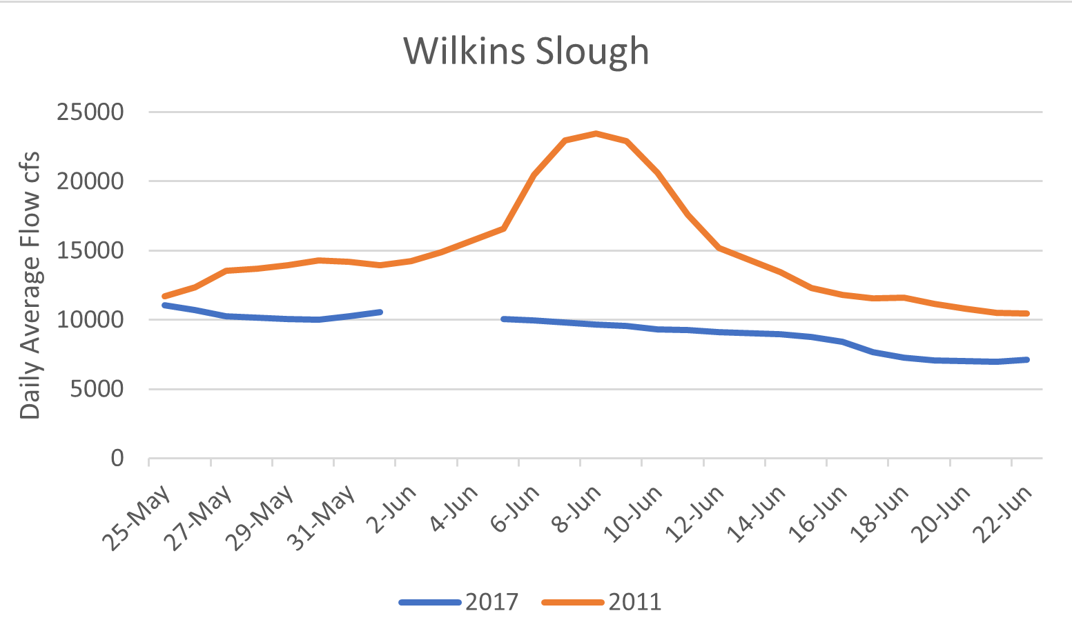
Figure 1. Flow in the lower Sacramento River at Wilkins Slough in late spring of 2011 and 2017.
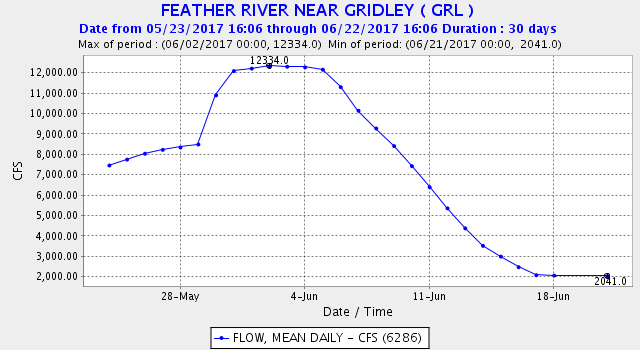
Figure 2. Lower Feather River flow at Gridley upstream of the mouth of the Yuba River.

Figure 3. Delta outflow in late spring 2011 and 2017.
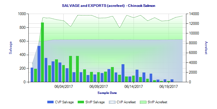
Figure 4. Salmon salvage at Delta fish facilities in June 2017. Source: https://www.wildlife.ca.gov/Conservation/Delta/Salvage-Monitoring
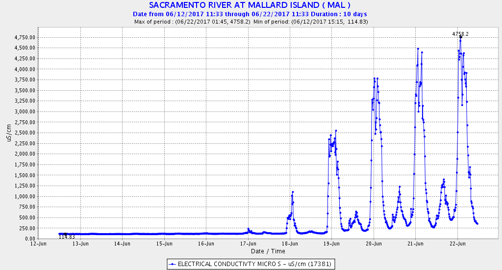
Figure 5. Salinity (EC) at Mallard Island gage near Chipps Island (eastern end of Suisun Bay) in June 2017.
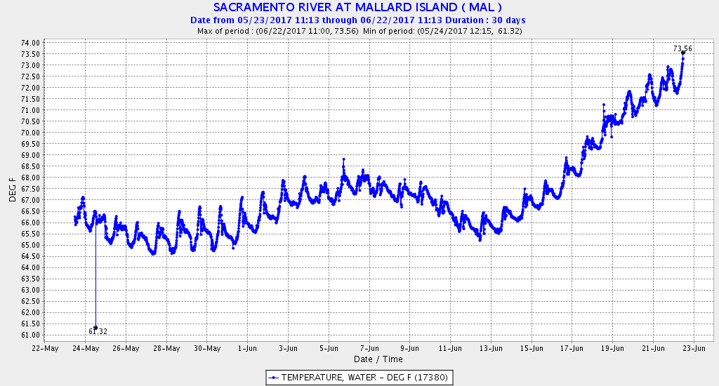
Figure 6. Water temperature at Mallard Island gage near Chipps Island (eastern end of Suisun Bay) in June 2017.