Lessons Learned from the 2013-2015 Drought

After the 2013-2015 drought, the National Marine Fisheries Service (NMFS) took a deep dive into “lessons learned” to help guide future regulatory permit processes, especially those that address the effects of future Shasta Reservoir operations on endangered winter-run Chinook salmon.  The drought proved to be a comprehensive adaptive management experiment on the effects of the US Bureau of Reclamation’s (Reclamation) operation of its Shasta-Trinity Division on Sacramento River and Bay-Delta fish populations.  Though the specific lessons learned focused primarily on one listed species, winter-run salmon, the effects manifested in different ways on other listed or special-status native fish species in the Central Valley and Klamath-Trinity rivers, including other runs of salmon, steelhead, sturgeon, and smelt, and even orca in the ocean.

In upcoming posts, I will discuss the ramifications of the “lessons” and their relevance to fish populations and water supply issues.  The focus will be on Sacramento Valley salmon and how Reclamation can adjust the operations of the Shasta-Trinity Division to help salmon and other fish populations recover.

March 2021 is a critical stage of decision making in managing resource allocation during what could be another dry year like water year 2020.  Reservoir storage levels are low (Figures 1-3), and Shasta’s cold-water supply (Figure 4) is low after a dry year.  Water year 2021 is dry so far.  The lessons learned need to be applied to avoid the fisheries disasters of the last drought.  Will the warnings and lessons be heeded?

Figure 1. Shasta Reservoir water storage for water years 2018-2021. Note reservoir refilled in wet year 2019 but not in below normal 2020, and storage enters 2021 at a low level.

Figure 2. Folsom Reservoir water storage for water years 2018-2021. Note storage entered water years 2020 and 2021 at lower levels, which does not bode well if water year 2021 is dry.

Figure 3. Oroville Reservoir water storage for water years 2018-2021. Note reservoir storage was poor after wet water year 2017 because of 2017 spillway failure.

Figure 4. Shasta Reservoir cold-water pool supply in calendar years 2014-16, 19, and 21. Note 2021 (black line) is beginning to trend toward drier year levels.

Scott River Coho 2020 Run Improves

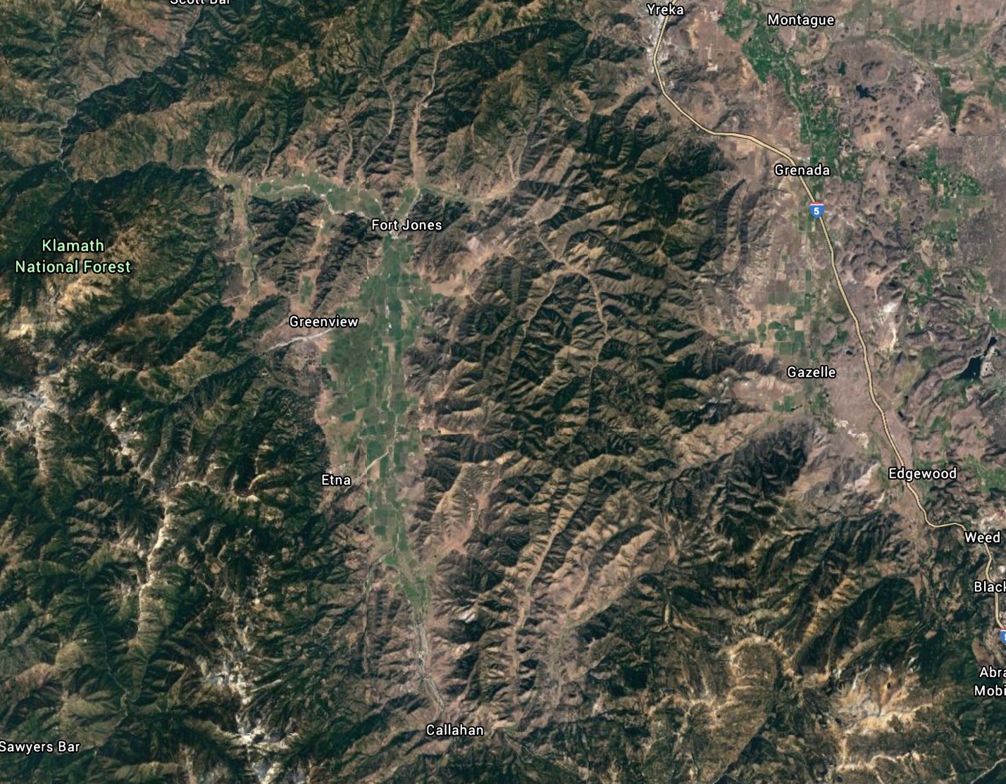
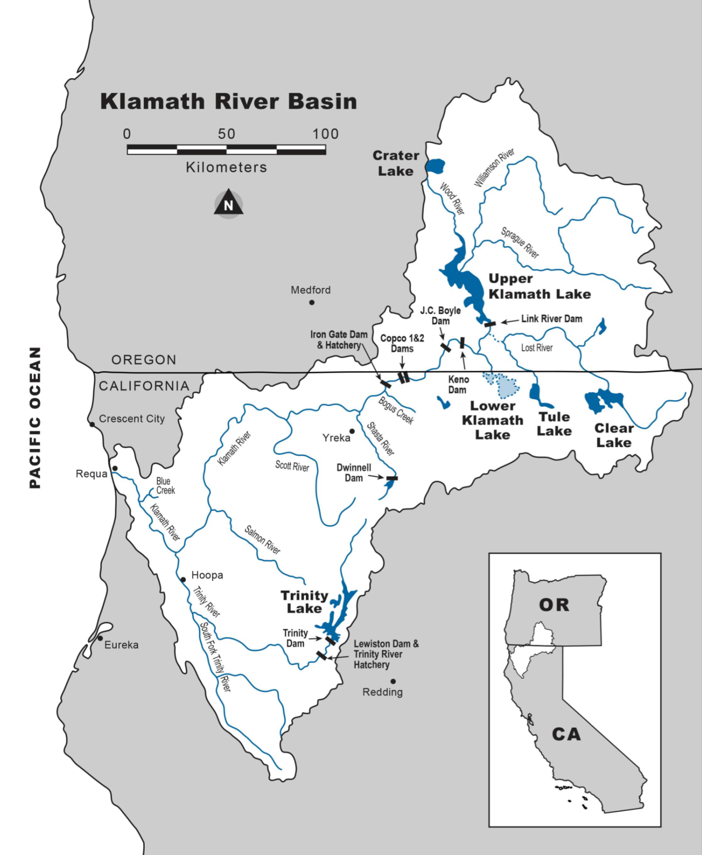
I last updated the status of Coho salmon in the Scott River, a major Klamath River tributary in northern California east of Yreka (Figures 1 and 2), in a January 2020 post. At that time, I lamented on the decline of the strongest distinct population subgroup, 2013-2016-2019, exemplified by the weak run in 2016 caused by the 2013-2016 drought. In this post, I am happy to report on the strong 2020 run and the surprise improvement of the 2014-2017-2020 subgroup (Figure 3).

The improvement in the 2020 run, despite a sparse spawning run in late-fall 2017, is likely a consequence of good water conditions in early water year 2018 (Oct 2017-Sep 2018, Figure 4) after wet water year 2017. The run had good access to spawning habitat and early rearing conditions from fall 2017 through the spring of 2018. The young coho were sustained though the dry summer of 2018 in spring-fed reaches of the upper river and its tributaries. Spring-fed habitats likely benefitted from the abundant winter 2017 snowpack. The Scott watershed had also benefitted from significant restoration of its over-summering habitat over the past decade.1

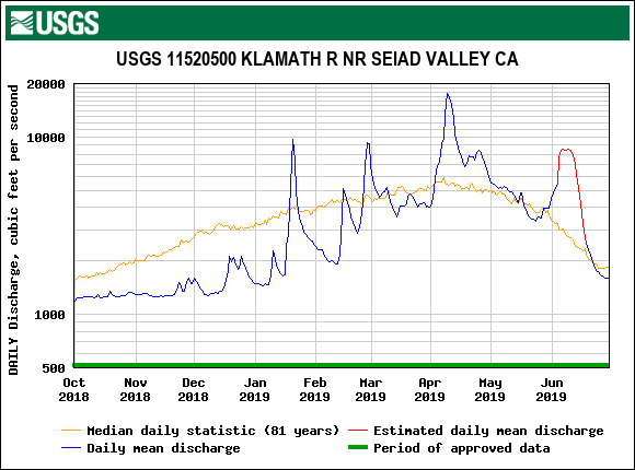
The yearlings of brood year 2017 then had good wet year emigrating conditions in late fall 2018 and early winter 2019 (Figures 4 and 5). There were multiple winter flow pulses to help the yearling coho smolts emigrate from Scott Valley and on down the Klamath to the ocean.

In summary, the spawning run in fall 2020 (from brood year 2017) was exceptional, benefitting from conditions that were a consequence of wet years 2017 and 2019. Over-summering survival in dry year 2018 was likely good because of good spring-fed flows and habitat in the upper watershed, a carryover from the good 2017 snowpack and restoration of beaver-pond habitat by Scott Valley stakeholder groups. This one small success bodes well for recovering other salmon and steelhead populations throughout the Klamath watershed, especially in a future dominated by climate change.2

Figure 1. Klamath River watershed with the Scott River west of Yreka, CA. (Source DOI.)

Figure 2. Google Earth view of the Scott River watershed with its snow-covered Marble Mtns to the west and the Trinity Alps to the south. Scott Valley, with its green hay fields from Etna to Fort Jones, was once called “beaver valley” due to its abundance of spring-fed beaver ponds and meadow streams ideal for over-summering salmon and steelhead.

Figure 3. Spawner-recruit relationship for Scott River Coho salmon. The number represents recruits (spawner counts) for that year versus spawners counts from three years earlier. For example: “13” represents spawner counts (recruits) in fall 2013 versus spawner numbers three years earlier in 2010. Number color represents different spawner subgroups (blue=subgroup 10-13-16-19). The Red circle highlights the significant outlier in 2016. The Yellow line is trend-line for years other than 2016 and 2020. Data source: CDFW weir counts.

Figure 4. Scott River streamflow measured downstream of Fort Jones as the river leaves Scott Valley, September 2017 to April 2019. Note the near average wet winters in 2018 and 2019, and dry summer in 2018 typical of the Mediterranean climate of northern California. The drier-than-average summer 2018 is indicative of water use for hay-pasture irrigation.

Figure 5. Klamath River streamflow measured downstream of the mouth of the Scott River, October 2018 to June 2019. Note the near average wet winter-spring with five distinct flow pulses typical of wetter years. of the Mediterranean climate of northern California. The flow pulses helped yearling coho from brood year 2017 emigrate to the ocean. The adults from brood year 2017 returned in late fall of 2020.


Water year 2021 is a bad year for American River wild salmon and steelhead production.

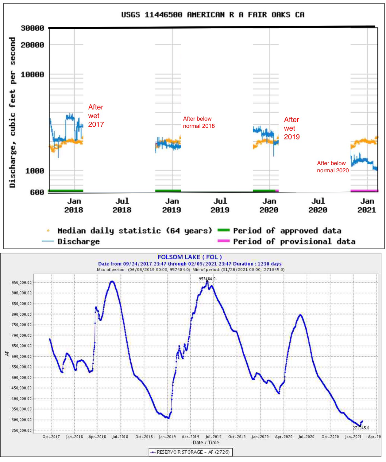
Water year 2021 has been bad for American River salmon and steelhead, with very low Folsom Reservoir releases Oct-Jan (Figure 1a).  Water year 2021 can best be described as a dry year, at least through the first quarter, somewhat on the drier side of 2018 and 2020, which were below normal water years.  However, whereas 2018 and 2020 followed wet years, water year 2021 follows a drier year.  This means 2021 started with poorer Folsom Reservoir storage (Figure 1b).

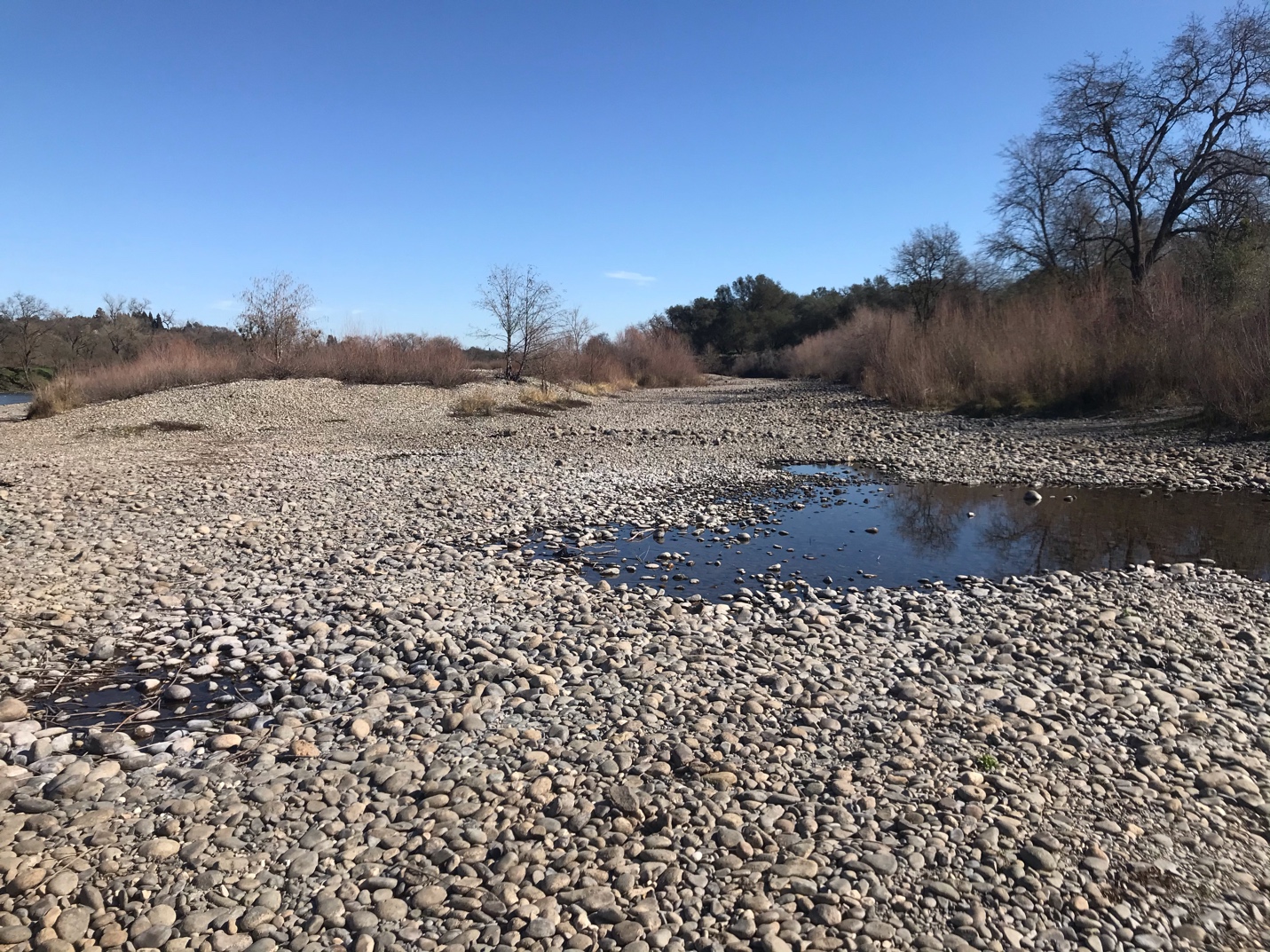
Water year 2021’s low fall and early winter reservoir releases from Folsom were nearer to 1000 cfs than the normal 2000 cfs.  As a result, much of the good spawning and early rearing fry habitat in the river below the dams remained dry (Figure 2).  In contrast, even in drought year 2014, the side channel spawning habitat remained slightly watered at 600 cfs river flow (Figure 3).  So, not only are redds dewatering in early winter of these dry years, the dewatering or drying of the side channels is getting worse.  This is either because the main channel is incising from persistent scouring or because sediment deposition blocks the entrance to the side channels, leaving perched side channels high and dry.

What got us into this predicament?  Was it simply Mother Nature or global warming?  Water management should take part of the blame (Figures 4 and 5).  The end-of-September Folsom storage in 2019 was higher than average at 700 TAF after a wet year.  Flood control rules required reservoir levels to be down to 600 TAF in November.  But storage dropped to 500 TAF, with higher-than-normal fall releases (Figure 6), essentially shorting the reservoir 100 TAF in the new 2020 water year.

The American River Water Forum Agreement Is designed to manage and protect all water users, including salmon.  Its formula for reservoir releases is based on natural flow input levels to the reservoir for that water year, which was lower than normal in 2020, thus leading to the prescribed low fall 2020 reservoir releases.  With reduced storage and low reservoir inflow in 2020, it was impractical to release the needed 2000 cfs for salmon and steelhead in fall 2020 without dropping the reservoir down to 200 TAF in what could be a drought year.

In conclusion, the American River salmon and steelhead are at the mercy of a precarious water management system that can go from good to bad in one water year.  One answer to this low fall flow problem is to ensure there is an extra 50-100 TAF of reservoir storage at the end of September to maintain the needed higher fall and winter flows for salmon and steelhead.  Because the channel morphology also continues to change, sediment supply and river morphology must also be taken into account, if not also adjusted.

Figure 1. Oct-Jan Folsom Reservoir releases 2017-2021 with long term average (above) and reservoir storage (below).

Figure 2. Sunrise side channel (looking upstream) end of January 2021 with some of the best spawning and rearing habitat for salmon and steelhead in the lower American River nearly dry with river flows at 1000 cfs. Other important side and main channel spawning and rearing habitats were similarly compromised. Note main channel is at extreme left middle of photo.

Figure 3. Sunrise side channel (looking downstream) on January 15, 2014. Some of the best spawning and rearing habitat for salmon and steelhead in the lower American River is in this side channel. In 2014 as shown, it was almost dry with river flows at 600 cfs. Note tops of salmon redds sticking out of the water in various stages of dewatering. The redds were dug by salmon earlier in fall 2013 at 1200 cfs.

Figure 4. Folsom Reservoir storage (acre-ft) in fall 2017-2020. Water years 2017 and 2019 were wet years, and water years 2018 and 2020 were below normal years.

Figure 5. Folsom Reservoir releases (cfs) in fall 2017-2020. Water years 2017 and 2019 were wet years, and water years 2018 and 2020 were below normal years.

Figure 6. Folsom Reservoir release (cfs) in fall 2019 with 64-year average.

Tisdale Weir Fish Passage Project

The California Department of Water Resources (DWR) Division of Flood Management is planning a major fish passage improvement to the Sutter Bypass: a notch in the Tisdale Weir.1 The notch will extend and enhance river flows into the bypasses, thereby allowing more access for juvenile salmon to rear in the bypass and improved upstream adult salmon passage from the bypasses back into the Sacramento River. DWR plans to place an operable gate in the notch, which DWR would open when flows over the weir ceased. This would extend the duration of flows into the bypass. As planned, DWR would not open the gate until after the weir had already overflowed.

In a May 2019 post I described similar improvements to fish passage into and out of the Yolo Bypass, including notches in the Fremont Weir at the upstream end of the Yolo Bypass where high flows in the Sacramento River overflow into it.

Potential Benefits:

Improving adult upstream passage and expanding rearing access to the bypasses with notch flows is a good concept. Improving rearing habitat in the bypasses is a further potential benefit. In wet years and in even in drier years (when the bypasses receive no Sacramento River overflows (or young salmon) even from the new notches), there will new potential benefits to tributary salmon populations (e.g., salmon from Butte Creek and the Feather and Yuba rivers). Sacramento River hatcheries can also improve their contributions by out-planting fry salmon to wetlands in the bypass. Managed wetlands in the bypass (including duck clubs and rice fields) can also be used for rearing wild and hatchery fry salmon, especially in drier years.

Potential Drawbacks:

More flow and access to the bypasses has the potential to put more salmon in harm’s way. More of the populations will rear and migrate in the bypasses. Stranding and predation in the bypasses are very real risks to young and adult salmon. Such risks need to be minimized. Rearing habitats need to drain effectively. Stranded young and adults should be rescued to the extent reasonably possible. There is a tendency in project plans and operations to ignore or downplay the stranding risks.

Further Needs:

There are multiple Sacramento River flood-control weirs that at times overflow into the Sutter Bypass and Butte Basin. These other weirs also need “fixing.” However, stranding (poor draining) in Butte Basin and Sutter Bypass will remain a serious problem, because hundreds of square miles of poor habitat conditions occur from top to bottom. Drainage and stranding need to be addressed before more access is provided. Information on smolt survival and run contribution from bypass rearing and passage is largely lacking.

Further Options:

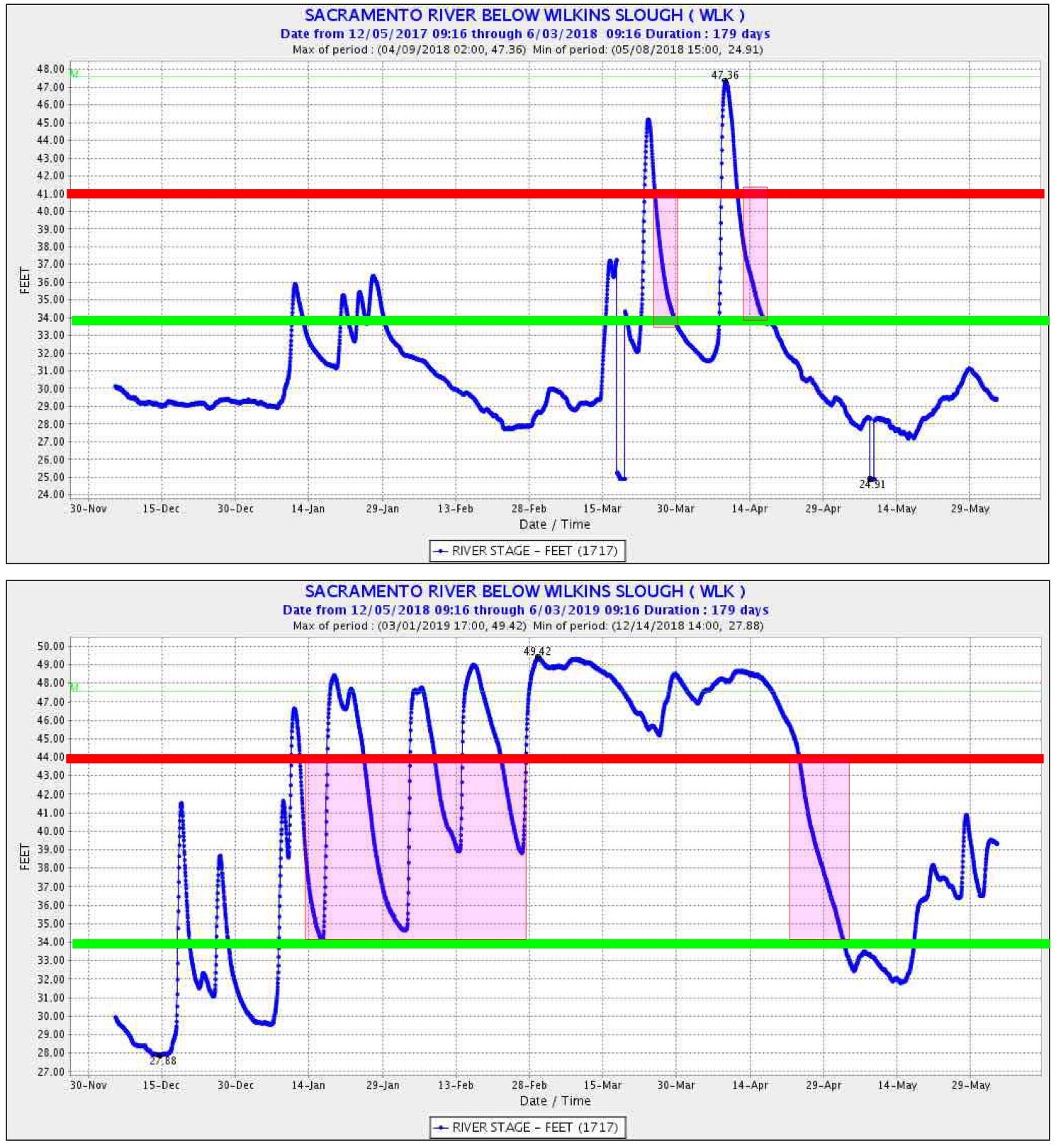
Often the first major flow pulses in the Sacramento River bring the strongest downstream movements of young salmon (Figure 1). Proposed operation of the Tisdale Weir calls for the new gates to remain closed until after the weir overflows (Figure 2). This operation does not take advantage of a significant potential project benefit. For instance, had the new facilities been in place during the peak early-January fry emigration in wet year 2019 (Figure 1), the weir gates would have remained closed (lower graph in Figure 2) when they could have been opened prior to weir overflow on about January 12. The gates could also be opened in earlier pulses and more frequently in drier years like 2018 (top graph in Figure 2). Furthermore, early openings in wet and dry years would accommodate access to floodplain habitats for juvenile winter-run salmon (Figure 3). DWR would need to develop some forecasting and decision-making protocols to evaluate opening the new gates prior to overflows. But water already in the bypass from other sources could partly mitigate the juvenile stranding potential, and adults that had strayed into the bypass would have a better opportunity to escape.

Summary and Conclusions:

The Tisdale Weir Project could provide substantial benefits to Sacramento River salmon. However, the proposed operation does not address potential risks on the one hand and may not fully take advantage of potential benefits on the other hand.

Figure 1. Catch of fall-run-sized salmon in screw traps in lower Sacramento River near the Tisdale Weir in winter-spring 2019

Figure 2. Proposed operation (purple shaded) of Tisdale Weir gates under dry year 2018 and wet year 2019 water level conditions. Gates could be operated at flows above the green line. The weir would normally overflow at water levels in the Sacramento River above approximately 44-ft elevation.

Figure 3. Pre-smolt catch of winter-run-sized salmon in screw traps in lower Sacramento River near the Tisdale Weir in winter-spring 2019.

Sacramento River Salmon Redd Dewatering in Fall 2020

The Bureau of Reclamation’s standard fall operation of Shasta Reservoir and Keswick Reservoir dewaters the redds of fall-run Chinook salmon in the upper Sacramento River near Redding.  The peak in fall-run Chinook salmon spawning is October-November.  Eggs and alevin (hatched sac fry) remain buried one to two feet down in the gravel spawning bed (redd) for about three months.  As I described in a November 2019 post and in prior posts, drops in flow and associated water levels cause varying degrees of redd stranding or dewatering, and the affected eggs and alevins die.

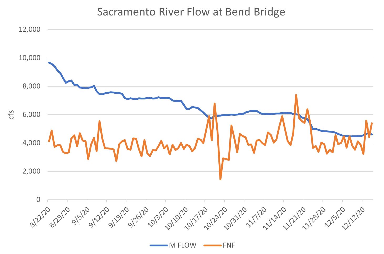
Fall-run salmon spawn from September to December, with a peak in October-November.  It takes several months for eggs to hatch and fry to leave the gravel beds.  Under unregulated conditions, fall-run salmon spawn in the generally stable flows of fall, and their young move toward the ocean with winter rains.  The natural versus present managed flow patterns are compared in Figure 1.

The problem has been getting worse in recent decades with the greater emphasis on water deliveries and on summer spawning conditions for winter-run salmon.  Each fall, after the summer irrigation and the incubation period for winter-run Chinook salmon wind down, Reclamation reduces reservoir releases from Shasta and Keswick by 20-30%, especially in drier years like 2020 (Figure 2).  Water levels in 2020 dropped about 3 ft over the fall (Figure 3), completely dewatering the earliest redds.

Reclamation should have averted the problem by maintaining fall releases from Shasta near 5000 cfs (Figure 3), at a cost of about 100,000 acre-ft of Shasta storage for the fall, or about 5% of Shasta dry-year minimum storage (Figure 4).  The need would continue into early winter, but the effect on Shasta storage would depend on winter precipitation.

Figure 1. Managed vs full natural flow from Keswick Dam to the upper Sacramento River in fall 2020.

Figure 2. Keswick Dam water releases in 2020 and 57-year average.

Figure 3. Water levels in Sacramento River below Keswick Dam in 2020.

Figure 4. Shasta Reservoir storage in 2020. Note the reservoir had 1.3 million acre-ft of additional water stored at the beginning of the year than at the end. Water year 2019 was wet and 2020 was dry.