April 13. CBS San Francisco reports:
The federal government is funding the release of millions of Baby Chinook salmon into Battle Creek at the Coleman Federal Hatchery outside Red Bluff. Brett Galyean, deputy project leader at Coleman Federal Hatchery, said, “It’s a big day. It’s the first time in two years that we were able to release all the fish on station…. Because of the drought the last two years, the environmental conditions in the Sacramento River — warm water, low flow — caused us to truck fish.”… However, of the 12 million fish released, only one percent are expected to return to Battle Creek in three years to spawn.
April 29. Recent fishing report states:
This spring’s striper fishing on the Sacramento River has been going very well with daily limits of large Sacramento River striped bass. Most of the action has been from Colusa downriver through Verona as the Sacramento River is very low due to minimal releases from Keswick Dam and high volumes of irrigation pumping from the lower Sacramento River. Stripers mostly 18 to 24 inches are coming in daily with some very large female stripers 15 to 25 pounds coming in as well. Drifting live jumbo minnows has been working best in the daytime while black worms or white swim baits are working at night. The Coleman National Fish Hatchery has released the remaining 6 million fall-run juvenile salmon smolt into the Sacramento River. With low flows coupled with the massive irrigation pumping, the lower Sacramento River from Butte City downriver through Verona is extremely low, leaving exposed sand and gravel bars across the river. This is setting the stage for an incredible striper fishing as the smolts arrive in the lower Sacramento River. Striper fishing should be incredible as the stripers feed day and night on the hatchery salmon smolt just like last month when the first round of hatchery Sacramento River salmon smolt were released. Sacramento fishing.com fishing guide Dave Jacobs has witnessed countless striper boils as the spawning stripers have fed around the clock on the salmon smolts from Butte City downriver through Verona.
May 1. Yet another fishing report notes:
The striper action has been incredible for the past several weeks. While many of the stripers are post spawn they are hanging out and destroying recent salmon plants coming out of the hatcheries…. Before the past weekend, he found great action on the Feather River, but heavy boat traffic over the weekend slowed down the Feather since an armada showed up. Salmon smolts were released in the Feather this past week, and the combination of low flows and clear water made for a killing zone for the smolts…. The bite lasted until most of the baby salmon made it to the Sacramento River, and I was able to follow them down the Sacramento a couple of miles until the fishing got tough…. The California Department Fish and Wildlife hatchery on the Feather river is planning on releasing their final stock of 1 million into the Feather river instead of trucking them around the river and Delta pumps to the Suisun Bay. The Federal hatchery on Battle creek released 4 plus million salmon fry this past week and will dumping an additional 1.9 million fall run fish into Battle Creek this coming Friday. The is [sic] opposed to these releases due to the current lower flows and clear water. With high numbers of spawning stripers and low / clear flows most of these fish will never make it as far as Sacramento. Past studies have shown that 94% of hatchery salmon released on the upper Sac never make it to San Pablo bay in these conditions.
May 2. SacBee Fishing continues the theme:
SACRAMENTO RIVER, Red Bluff to Colusa – Salmon smolts have been released from Coleman National Fish Hatchery, and are expected to fuel a hot striper bite from Butte City to Verona. The river is dropping, which caused many of the stripers to drop downstream last week. Anglers now expect stripers to move upriver to feed on the salmon smolts.
Sacramento River Conditions
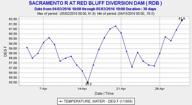
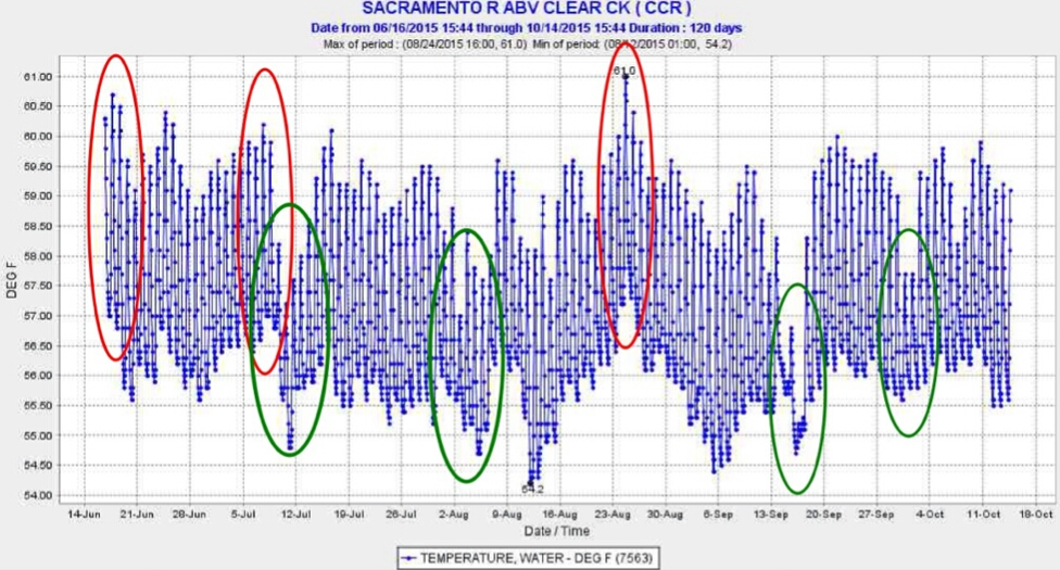
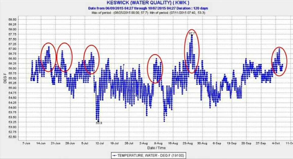
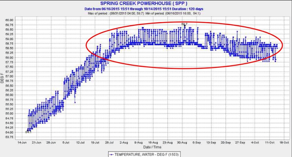
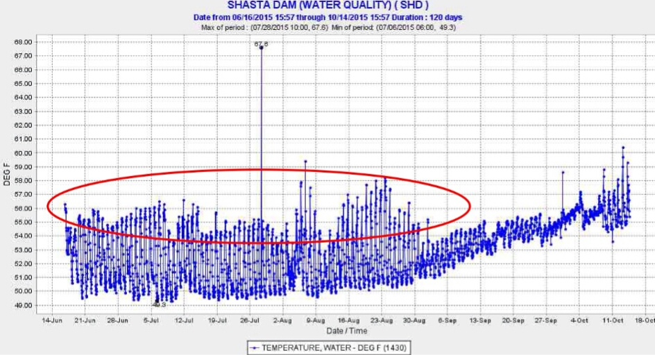
The Sacramento River water quality Basin Plan objective requires no water temperature greater than 56°F upstream of Hamilton City and no temperature greater than 68°F upstream of Sacramento. Water temperature Red Bluff (upstream of Hamilton City) has already reached a daily average of 62°F, well above the required limit (and this with Shasta full of cold water). Water temperatures below Hamilton City have reached 69°F (at Wilkins Slough). Downstream-migrating smolts are stressed and more vulnerable to predation as water temperatures approach 60°F, yet managers continue to release hatchery smolts from the Battle Creek and Feather River hatcheries. Adult winter-run and spring-run Chinook salmon, now migrating upstream in the Sacramento River, are also being stressed by water temperatures greater than 65°F. The 60-65°F range is optimal for striped bass feeding and metabolism. ARE THE HATCHERY SMOLTS SIMPLY CHUM FOR STRIPERS???