Well the final tallies came in for the 2015 Fall Midwater Trawl Survey. Indices for two smelt were again record lows as expected. Not quite zero, but close. The Smelt Working Group continues to track Endangered Species Act incidental take permit limits set in the 2008 federal biological opinion based on South Delta salvage: December – No salvage, no concern, so pump like hell.
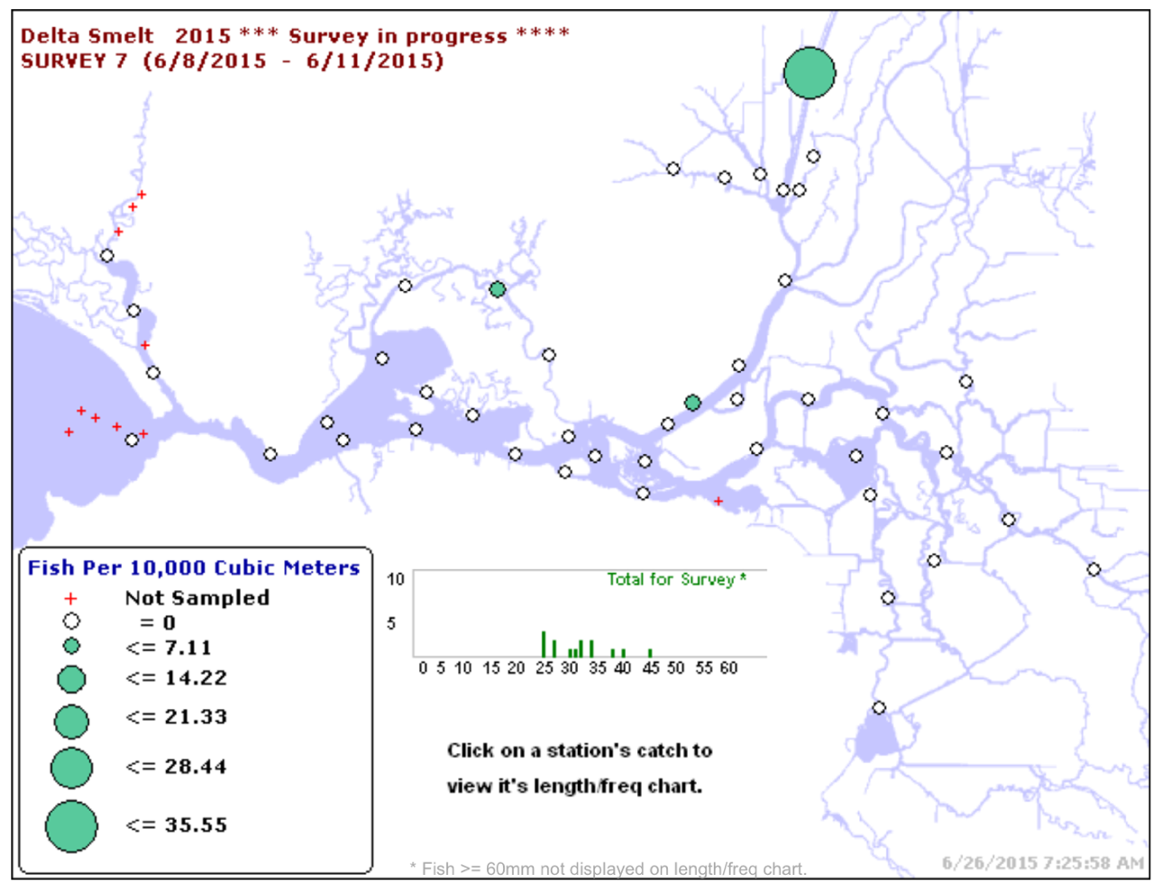
Delta Smelt
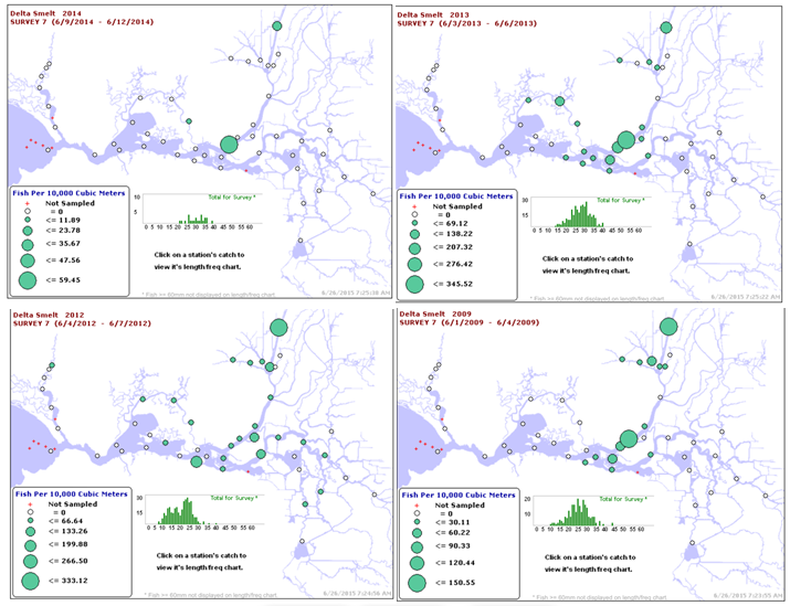
It hard to tell from Figure 1, but 2015 came in with an index of 7, compared to the record low 9 in 2014. No fanfare this year from CDFW as back when 2011 index came out. No articles in the SacBee. Just another nail in the coffin.
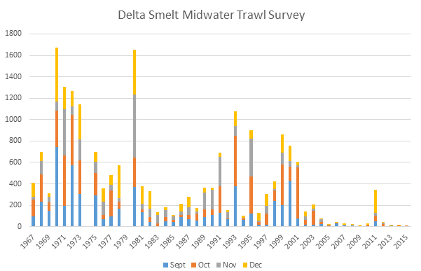
Figure 1. Delta Smelt Fall Midwater Trawl catch for September-December 1967-2015 (no survey in 74, 79). Yearly index is total catch of four monthly surveys.
Longfin Smelt
It is even harder to tell from Figure 2 that the index for Longfin Smelt came in at 3 compared to last year’s record low of 16.
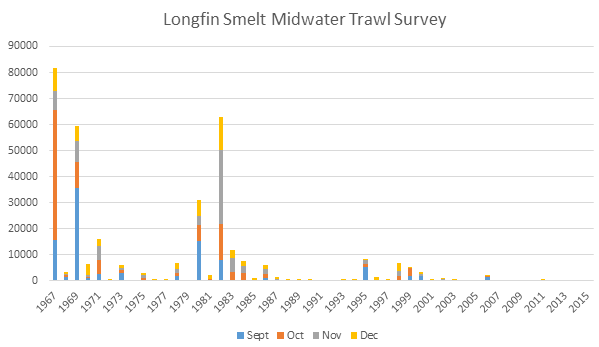
Figure 2. Longfin Smelt Fall Midwater Trawl catch for September-December 1967-2015 (no survey in 74, 79). Yearly index is total catch of four monthly surveys.
Smelt Working Group
The Smelt Working Group met weekly in December after a 6 month hiatus.1 A couple of the low points:
“The WY 2016 adult Delta Smelt incidental take (IT) is 56, as is stated in the Service’s December 23, 2015 memo to the Bureau of Reclamation. The method to calculate the IT is that which is described on p 386 of the 2008 BiOp, with a correction (as discussed in the memo). The alternative approach that the Service presented to the 2015 independent review panel at the Long-term Operation Biological Opinions annual science review will be piloted this year.” Thus the Working Group continues to use the old take limits from 2008 and has adopted the new more liberal method of calculation. Given the remnant population level, allowing the take of 56 Delta smelt in salvage is indefensible. For every fish taken in salvage, a hundred are lost in Clifton Court Forebay.
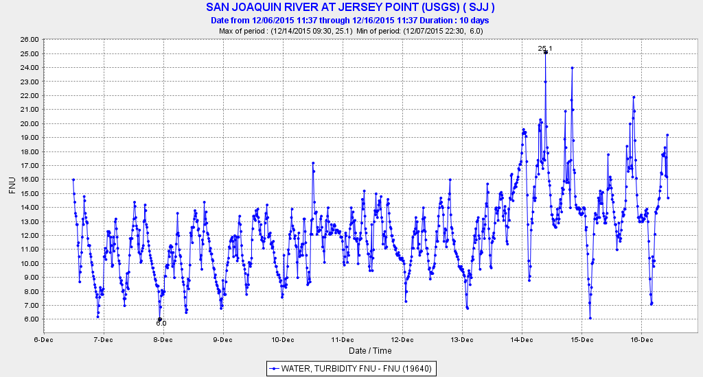
“The Working Group reviewed Delta Smelt distribution and salvage data, and current Delta conditions and provided no recommendation as yet for a change in water operations for either Delta Smelt or Longfin Smelt. However, members of the Working Group did conclude that entrainment risk is increasing and the group will meet again December 30 to further discuss a potential recommendation to the Service.” Indeed, Delta Smelt had been detected in the central Delta at Jersey Point and Prisoners Point, and exports had increased from 800 to 6700 cfs. Yet the Working Group prescribed no change in water operations.
The Smelt Working Group planned to meet on December 30. I cannot wait to see their notes from that meeting.