
The State Water Resources Control Board is responsible for enforcing water rights and the Sacramento River Basin Plan that protects beneficial uses including fish and water quality.1 The Basin Plan’s 68°F objective for the lower Sacramento River is clearly being violated right now because of low Sacramento River flows brought about by lower than normal Shasta releases and a 100 % allocation of water to Sacramento Valley water contractors. The State Board has jurisdiction over both of these factors through control of water rights. The State Board is about to review Reclamation’s Water Temperature Plan (WTP) for summer 2016, which calls for a 10,500 cfs release in July, several thousand cfs below normal, to conserve Shasta’s cold-water pool for salmon through the summer and fall. The WTP however has no provisions for cutting downstream water use. Thus, flows in the lower Sacramento River will be lower, with higher water temperatures that violate the Basin Plan. The flows must be raised at Wilkins Slough (RM 125) by either increasing Shasta releases or reducing water diversions, or a combination thereof.
The Basin Plan objective of 68°F is there to protect salmon and sturgeon migrating and rearing in the lower Sacramento River. Water temperatures above 68°F are stressful to the fish, affecting growth, survival, and subsequent reproduction. Present water temperatures in the lower river (Figure 1), caused in part by low flow (Figure 2), are lethal to salmon and sturgeon. In 2010 and 2012, water years similar to 2016, flows were higher and water temperatures were lower in early summer (Figures 3-6).
The State Board, in reviewing the WTP, must explicitly consider flows and water temperatures in the lower Sacramento River under its broader responsibilities to protect fish as prescribed in the Basin Plan and in various water rights orders.
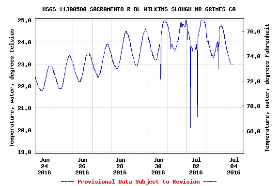
Figure 1. Water temperature of lower Sacramento River at Wilkins Slough (RM 125) in early summer 2016.
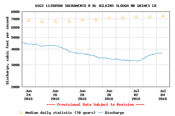
Figure 2. Sacramento River flow at Wilkins Slough (RM 125) in early summer 2016.
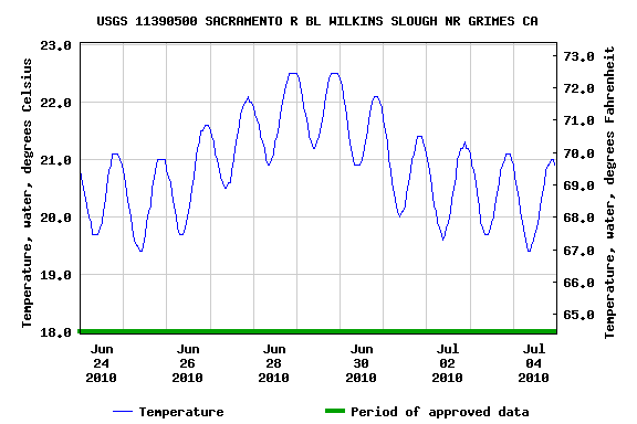
Figure 3. Water temperature of lower Sacramento River at Wilkins Slough (RM 125) in early summer 2010.
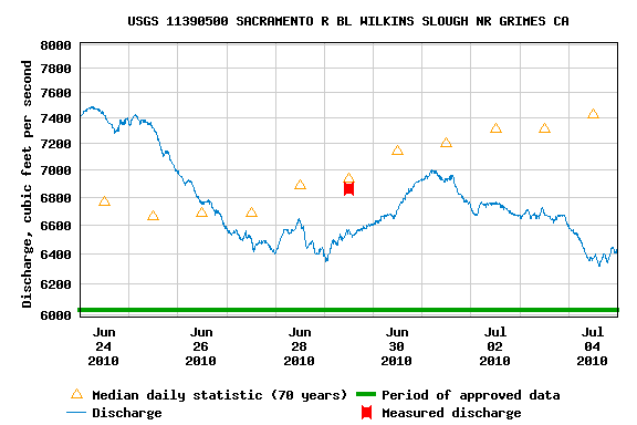
Figure 4. Sacramento River flow at Wilkins Slough (RM 125) in early summer 2010.
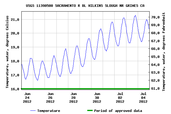
Figure 5. Water temperature of lower Sacramento River at Wilkins Slough (RM 125) in early summer 2012.
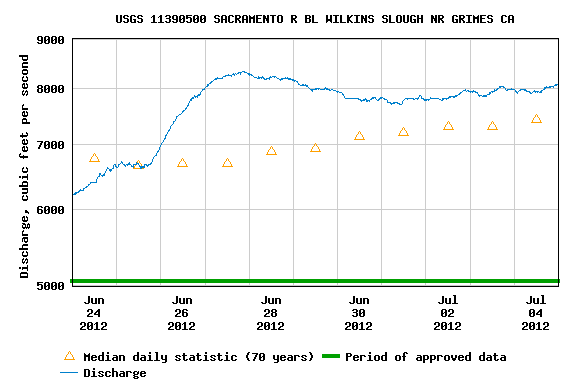
Figure 6. Sacramento River flow at Wilkins Slough (RM 125) in early summer 2012.