
Conditions in the lower American River have been bad all year, and are getting worse.1 Folsom Reservoir storage never recovered this spring and is critically low this summer (Figure 1). Releases from reservoir to the river have been low (Figure 2), resulting in excessively warm river water temperatures (Figure 3).
In a recent post on the Water Forum’s blog, Jessica Law, the new executive director of the American River Water Forum, described current conditions for the lower American River:
I won’t sugarcoat it. Conditions in the river will be bad. However, the Water Forum and our partners are working hard to ensure conditions are as good as they can possibly be, and to minimize harm to fish and habitat. As you may have seen on the news, we began this year with a near-normal snowpack. In most years, the snowpack melts and feeds our lakes and rivers. This year, the snowpack disappeared in the span of several weeks, soaking into the dry soil or evaporating—perhaps foreshadowing what may turn out to be the case study for climate change impacts on our water supplies and environment.
In a recent interview with Matt Weiser posted in Maven’s Notebook, Ms. Law further elaborated about the update of the original Water Forum Agreement from the year 2000.
“The biggest thing we’ve done is develop and implement a Modified Flow Management Standard with Reclamation that governs water movement in the Lower American River and optimizes conditions for fish. So that’s huge. …
But at some point, nature is moving faster than we can keep up. This year, with another extreme drought in play, is a great example of that. We had better water storage in all reservoirs coming out of a dry year than we ever had. This was very intentional by Reclamation and the Department of Water Resources. Still, we’re in a really bad situation this year.
Yet there is more to the story than natural conditions. Notwithstanding the Modified Flow Management Standard, fisheries in the lower American River have been struggling for many years.2
Reservoir inflows are low and water temperatures are high in summer of drier years (Figures 3 and 4), because Reclamation fails to conserve storage and the reservoir’s cold-water pool in most years. In the drier years, high June releases to meet Delta requirements and/or export demands lead to lower summer storage and high July water temperatures (Figures 1-3). Low reservoir storage levels lead to lack of access to the cold-water pool. Peaking power releases in afternoon-evening period draw warmer water from the surface of the reservoir (Figure 5).
A part of the solution to the problem is to have strict rules on end-of-year storage (Figure 7):
- 500,000 AF in high-storage years
- 350,000 AF in intermediate-storage years
- 250,000 AF in low-storage years
It is no longer enough to set end-of-September storage targets. Climate change means in part that more autumn months are very dry. Exports in the fall (and a transfer season now extended through November) pull down CVP storage or at least slow reservoir refill. Storage at the end of November or end of December needs to an explicit part of the carryover calculus. Figure 7 shows end-of-November as the requirement.
Complying with these rules (criteria) would occur through strict management of summer-fall storage releases. It would begin with the higher requirements for high-storage years, when there is water to manage. This would help prevent excessive drawdown from cascading into catastrophic conditions in one year.
Conserving storage in spring of drier years is also important in maximizing water storage for the beginning of summer. Use of Folsom Reservoir to meet short-term Delta water quality demands in winter and spring of drier years like 2021 (Figure 6) exacerbates summer storage and water temperature problems. This also wreaks havoc on the lower American River’s steelhead spawning habitat and salmon and steelhead rearing habitat.3
What is running away from managers of the lower American River is not only climate conditions. It is also the relentless pressure on other Central Valley Project (CVP) and State Water Project (SWP) reservoirs that forces Folsom Reservoir to shoulder more of the burden than it can bear. The explicit goal of “maximizing deliveries” in purpose-and-need statements of the 2019 Biological Opinions for the operation of the CVP and SWP are just one aspect of this pressure.
The over-delivery of irrigation water from Shasta Reservoir to Sacramento River Settlement Contractors in the spring and summer of 2021 made much less water from Shasta available to meet Delta water quality needs. Hence, the sudden demands on Folsom. There is a direct line between deliveries along the Sacramento and the amount of water in storage at Folsom Reservoir. These related problems must be solved to allow implementation of Folsom storage levels to be truly protective.
In summary, Water Forum 2.0 should focus on conserving Folsom Reservoir’s cold-water pool, providing access to the cold-water pool, minimizing the adverse effects of peaking power on river water temperature, and minimizing use of Folsom storage for short-term Delta water needs. While much of the focus must be on drier years, especially years like 2015 and 2021, overuse in high-storage type years can also lead to future problems.
For more detail on the salmonids and their habitat conditions in the lower American River see https://www.calfish.org/Portals/2/Programs/CentralValley/LAR_RST/docs/2020%20LAR%20RST%20Emigration%20Monitoring.pdf .
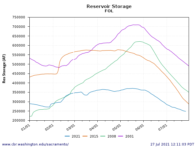
Figure 1. Folsom Reservoir storage patterns in four drier years: 2001, 2008, 2015, and 2021.
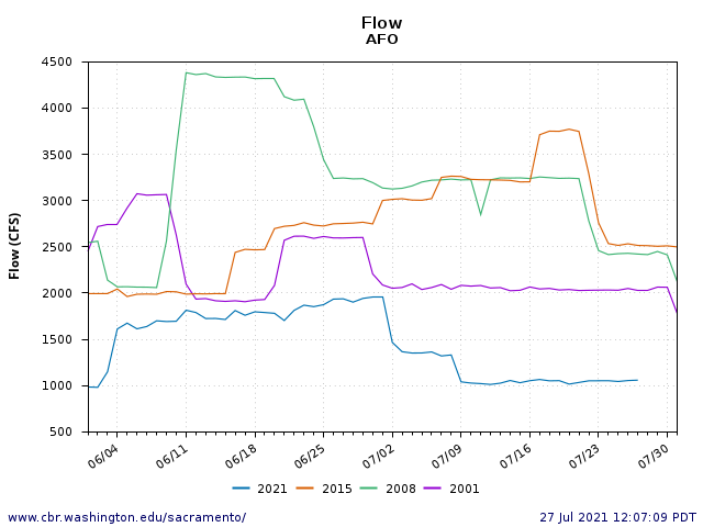
Figure 2. Folsom/Nimbus Reservoir releases to the American River at Fair Oaks in June-July of four drier years: 2001, 2008, 2015, and 2021.
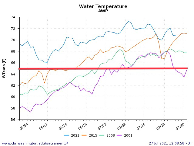
Figure 3. Water temperature in the lower American River at William Pond gage in June-July of four drier years: 2001, 2008, 2015, and 2021. Red line is the upper limit of water temperature considered safe for salmonids.
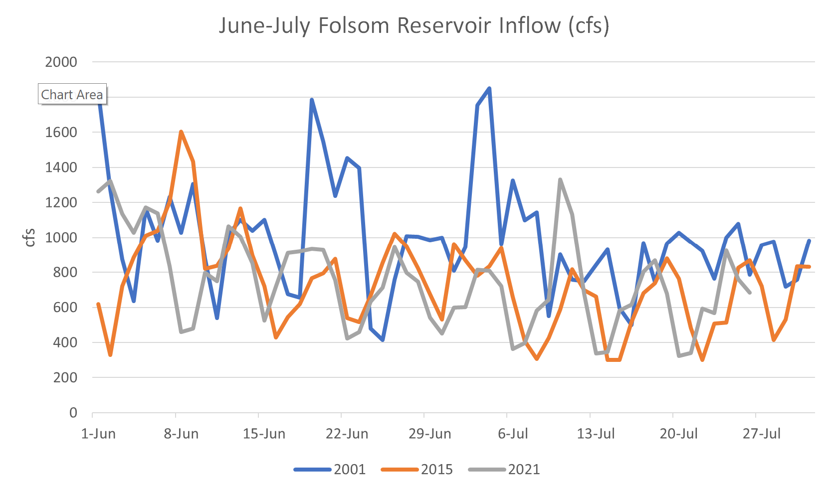
Figure 4. Dry years 2001, 2015, and 2021 June-July inflow to Folsom Reservoir. Note 2015 and 2021 were very similar.
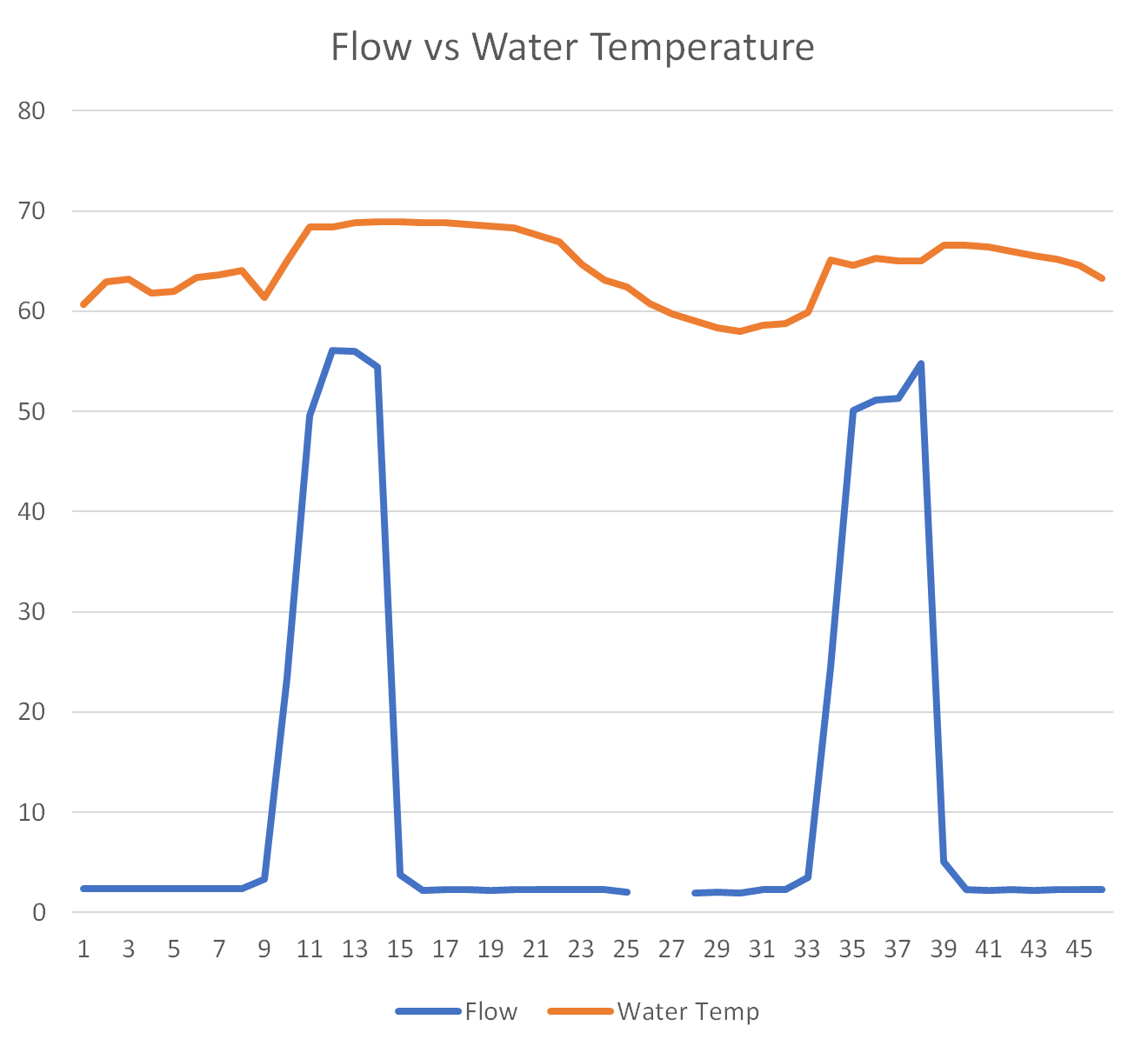
Figure 5. 48 hours of flow (cfs/100) and water temperature (oF) from Folsom Dam beginning 7/26/21 at 08:00 hours.
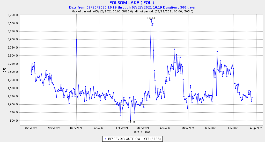
Figure 6. Folsom Reservoir daily-average storage releases (cfs) October 2020 to July 2021. Note each rectangle represents approximately 15,000 acre-ft of storage water. The three peaks in spring represent approximately 100,000 acre-ft of the end-of-June storage in Figure 1, or roughly about half the difference between 2015 and 2021 beginning-of-the-summer storage. Higher releases at the end of 2020 also contributed to the difference, along with low precipitation and snowmelt in 2021.
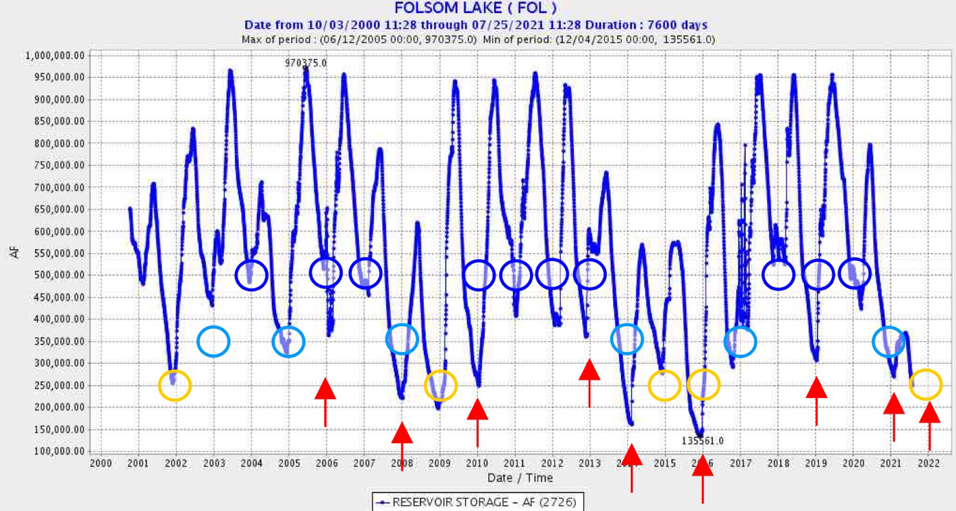
Figure 7. Folsom Reservoir daily-average storage (acre-feet) 2000-2021. Recommended minimum storage criteria are shown by circles: blue for high-storage years; light blue for intermediate-storage years; yellow for low-storage years. Red arrows are years that grossly exceeded such criteria.
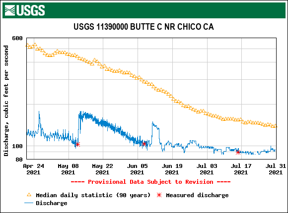
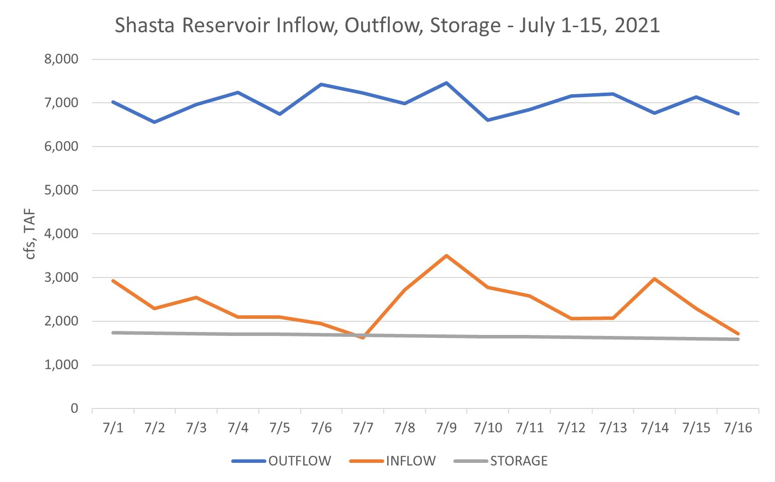
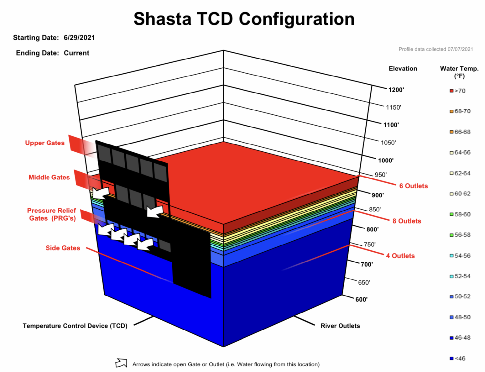
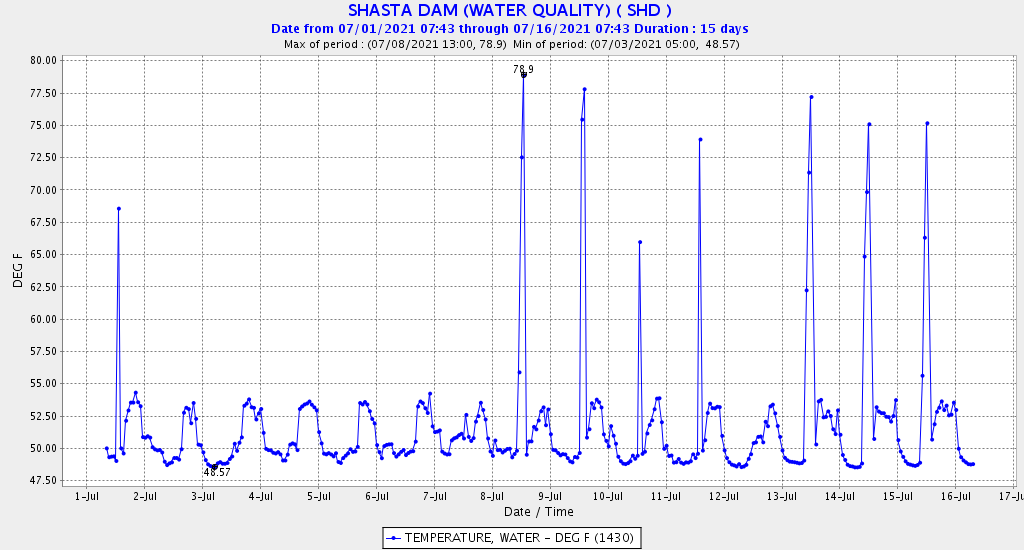
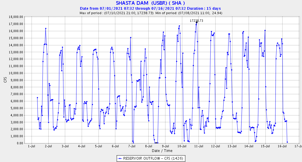 Figure 3a and 3b. Hourly water temperature (a) and flow (b) release pattern from Shasta Dam during first half of July 2021. Note most peaking-power releases are in afternoon and evening hours, with water temperatures several degrees higher during the daily peak generation. Daily average releases were 6500-7500 cfs, with peaks on the 6th and 9th.
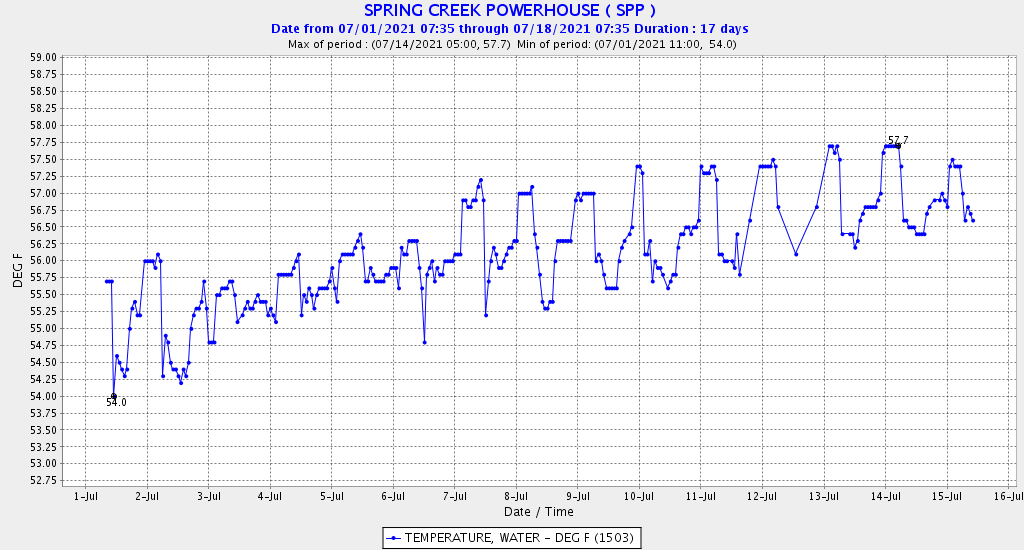
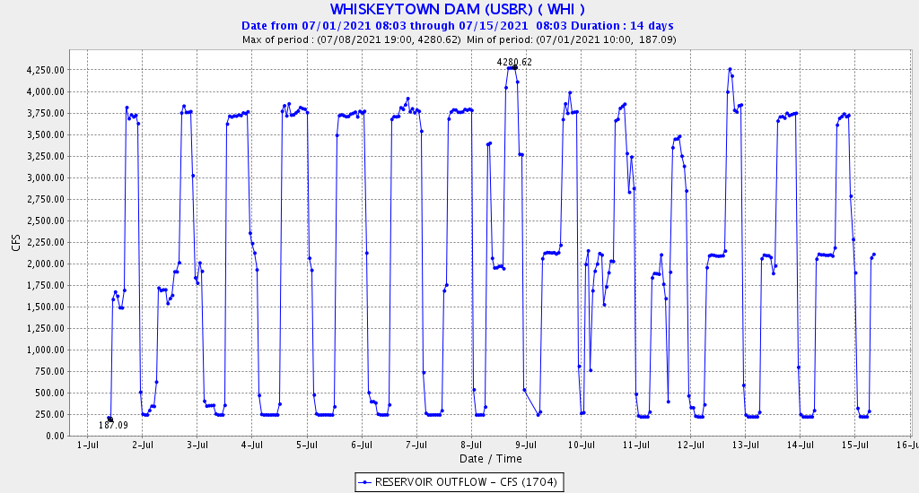 Figures 4a and 4b. Hourly water temperature (a) and flow (b) release pattern from Whiskeytown Dam during first half of July 2021. Note most peaking-power releases are in afternoon and evening hours, with water temperatures in the middle range of the daily pattern or about 1ºF below the daily maximum. Note the base flow of 250 cfs is to Clear Creek, with the remainder to Spring Creek powerhouse on Keswick Reservoir. Also, note peak releases to the Spring Creek powerhouse were about 3500 cfs for 12 hours from July 3-8. Daily average releases rose from about 1000 cfs on July 1 to 2000 cfs on July 4, then dropped to 1500 cfs on July 11, only to increase again through July 15.