A recent paper in the prestigious Canadian Journal of Fisheries and Aquatic Science discusses Central Valley salmon. The paper concludes: “Wild stocks in several California rivers are now dominated by hatchery fish (Barnett-Johnson et al. 2007; Johnson et al. 2012; Quiñones and Moyle 2014), potentially eroding the long-term resiliency of wild, locally adapted populations by disrupting selection for heritable traits that improve lifetime reproductive success in variable environments.”
First, wild or naturally spawning stocks or runs of fall-run Chinook salmon in Valley rivers are all dominated by hatchery salmon. Without hatcheries and straying of hatchery salmon to non-hatchery rivers (e.g., Yuba, Cosumnes, etc.), there would be almost no salmon runs of significance.
Second, there are hardly any significant locally adapted (wild) traits left to erode. River flows, water temperatures, gravel spawning beds, large woody debris, predators, and channel morphologies have become so limiting or compromising that wild salmon survival is nearly nonexistent.
Third, the “lifetime reproductive success” potential of wild fish is primarily compromised by water and fisheries management. Flows are too low, and fisheries continue harvesting much of the wild salmon production.
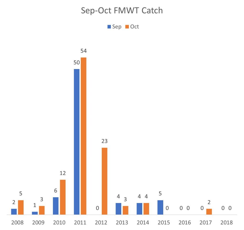
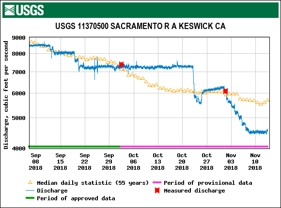
Fourth, the recent salmon population crashes of 2009 and 2016 are blamed by many salmon scientists on poor ocean conditions, with little regard for poor river habitat or water management as contributing factors, let alone hatcheries. By contrast, the federal Battle Creek hatchery managers knew they had to truck some of their smolt production to the Bay during the drought because of poor river conditions if they hoped for some survival and contribution to future runs.
The authors of the paper imply that hatcheries are the problem. No doubt the hatchery programs could be improved to lessen their negative effects and improve their contribution to salmon recovery. But for sure the fault is not with the hatcheries. Lack of support for hatcheries by scientists and resource agencies will dry up hatchery funding by water-user entities and make the problem worse.
The paper’s authors conclude: “There is a growing concern that salmon populations in the C[entral] V[alley] of California are becoming dependent upon hatchery supplementation, a conservation status recently identified as “mitigated extinction” Baumsteiger and Moyle 2017).” California salmon have been dependent on hatcheries for many decades. This is not a new development. Dams and diversions wiped out the wild salmon and their critical habitats, while hatcheries kept the dream going. Now scientists want to take the dream away.
Give the authors some credit for ending by saying: “Hatcheries can play a key role in the recovery of wild stocks, supplementing the fishery, and the reestablishment of natural areas, but only with cautious and appropriate management.” Despite the ambiguity, I had similar recommendations for improving hatchery programs in a recent post.