Welcome to the California Fisheries Blog

The California Sportfishing Protection Alliance is pleased to host the California Fisheries Blog. The focus will be on pelagic and anadromous fisheries. We will also cover environmental topics related to fisheries such as water supply, water quality, hatcheries, harvest, and habitats. Geographical coverage will be from the ocean to headwaters, including watersheds, streams, rivers, lakes, bays, ocean, and estuaries. Please note that posts on the blog represent the work and opinions of their authors, and do not necessarily reflect CSPA positions or policy.

The Water Temperature of the Bay-Delta is Currently Unsuitable for Delta Smelt in Summer

The last significant brood year reproduction of Delta Smelt occurred in 2011 (Figure 1a and 1b). The last significant brood years occurred from 2010-2012, and the population then collapsed during the 2013-2015 drought. The Delta is too warm in summer to allow a Delta Smelt recovery.

The demise of the Delta Smelt started in the late 1990s and accelerated from 2005-2006, above-normal and wet years that had unusually warm western Delta water temperatures in the prime Delta Smelt low-salinity-zone rearing habitat. The 2005-2026 decline of Delta Smelt and other pelagic Delta species was termed the Pelagic Organism Decline (POD).1 The POD was studied for two decades, with multiple factors considered, including warming of the Delta as it relates to increasing Delta water exports and the associated lower Delta outflow.

After two decades of new environmental data available for the Delta, it looks more and more like increased water temperature was the main culprit in the demise of Delta Smelt.  One of the best sources of long-term water temperature data is the gage at Emmaton in the western Delta, near the confluence of the Sacramento River and San Joaquin River channels at the entrance to San Francisco Bay in east Suisun Bay (see map, Figure 14). Water temperatures in early summer in wetter years 2005-2006 were higher than average and into the 73-75oF lethal range for Delta Smelt (Figures 2 and 3).  Similar warm temperatures were recorded at the Collinsville gage in east Suisun Bay in summer 2005 and 2006 (Figures 4 and 5). The western Delta and eastern Suisun Bay are the prime early-summer low-salinity-zone habitat of Delta Smelt.

The warmer summer trend in the western Delta continued after 2010-2012, the last Delta Smelt  recovery years (Figures 6-9).  Water temperatures were also high in summer in west Suisun Bay in many recent years (Figure 10).

Causes

Generally, the blame goes to Climate Change (i.e., Global Warming, El Niños, etc.) that cause droughts and warmer air temperatures.  It is difficult to put blame on any one factor, especially when the potential factors are highly variable, often not controllable, or not always measured.

However, for Delta Smelt that usually live only one year, it is useful to look for causes in sudden drops in population indices or periods of declines (like droughts).  I have analyzed many of these factors and trends, and I often come back to July (early summer) when juvenile Delta Smelt are usually settled into the low salinity zone in the western Delta and Suisun Bay.  If that key habitat area gets too warm, then it only takes a few days to kill-off most of the population.

For this reason, I tend to focus on POD years 2005 and 2006 as a prime factor in the demise of Delta Smelt. As shown in Figure 3, July water temperatures reached lethal levels during the POD years; they had been at non-lethal levels in most years of the 1990s.  A major change was that south Delta exports under Water Rights Decision 1641 (after 1999) were greater than occurred during the 1990s (Figure 11, Table 1). July exports were about 25% greater during the POD years, because D-1641 allowed higher exports (Figure 12). West Delta water temperatures were particularly high in the summer of water year 2005 (Figure 13).  The combination of high early- summer (June-July) exports (Table 1) and high July water temperatures was a likely contributing factor to the post-2002 Delta Smelt summer and fall indices.

Table 1. June and July monthly-average exports in 2005.  Pre-1995 exports limits are shown.

Month June July
Export Rate CFS 10,100 11,900
Pre-1995 Max CFS 6,000 9,000


After the 2010-2012 period in which the Delta Smelt population showed some recovery, the population collapsed to near zero. That decline was likely related to the persistent lethal water temperatures in summer in the western Delta and east Suisun Bay. There is ample evidence of warmer summers under the temporary urgency change petitions and orders in the two most recent multiyear droughts (2013-2015; 2020-2022).2

In summary, it is extremely difficult for the Delta Smelt population to recover in the Bay-Delta Estuary under current water management and environmental conditions, because water temperatures are too high in summer. Surely it remains possible to affect change with more progressive water management, but the capacity to affect change diminishes
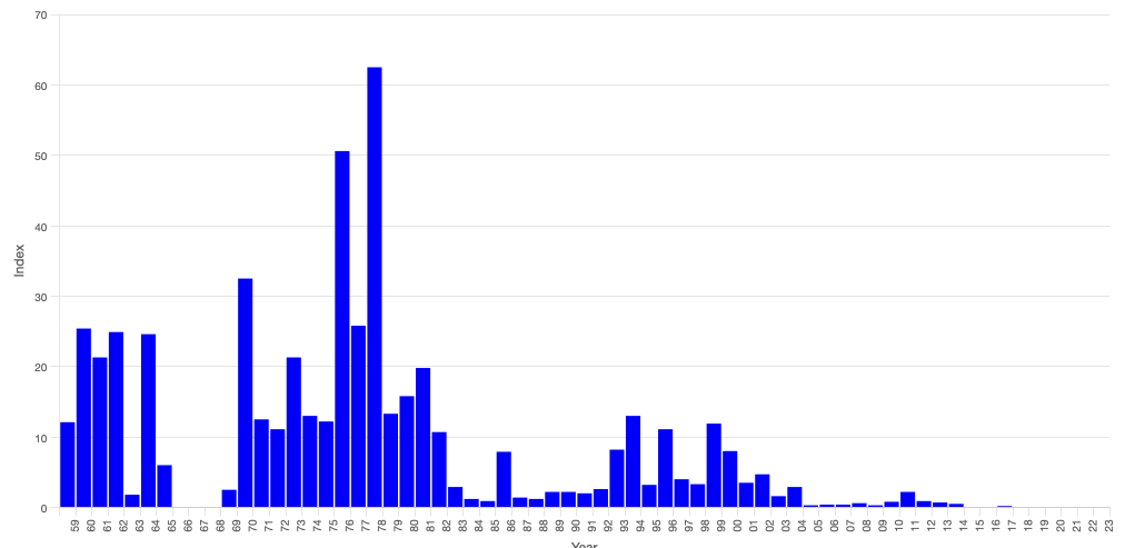
Figure 1a. Delta Smelt Summer Townet Survey Index 1959-2023. Source: CDFW
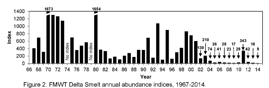
Figure 1b. Delta Smelt Fall Trawl Survey Index 1967-2014. Source: CDFW.
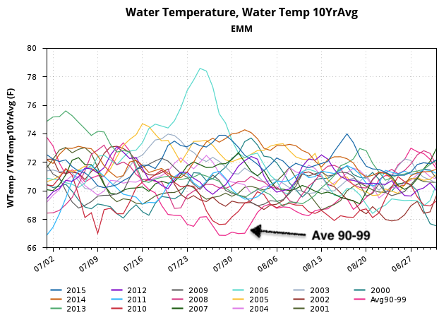
Figure 2. Summer water temperature at Emmaton gage near the confluence of the Bay and Delta from 2000 to 2015. See map (Figure 14) for gage location.
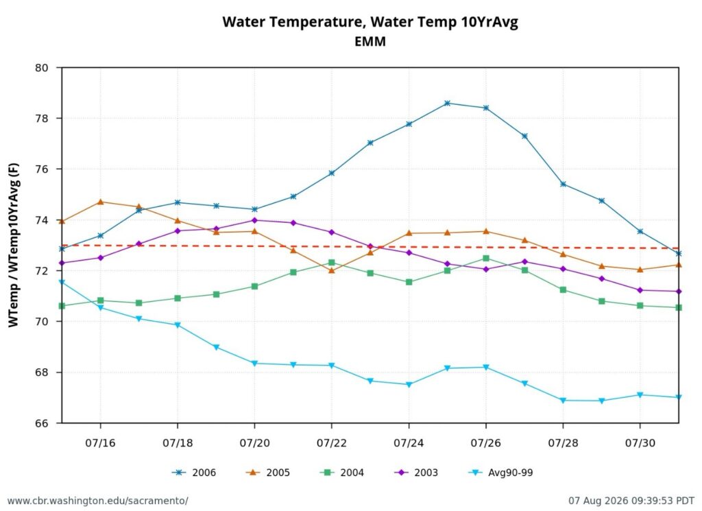
Figure 3. Average daily water temperature is shown for July of years 2003-2006 at Emmaton in the western Delta. Also shown is the average water temperature at Emmaton for the same dates for years 1990-1999. The red line is the level above which water temperature is considered highly stressful or lethal to Delta Smelt with long-term exposure.
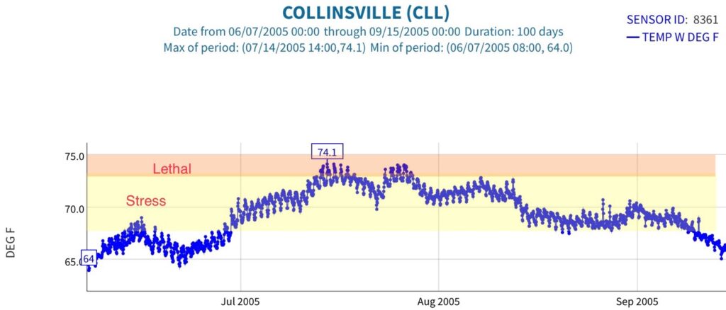
Figure 4. Water temperature (recorded hourly) at Collinsville gage in eastern Suisun Bay in 2005. Stress and lethal levels on Delta Smelt shown in colors.
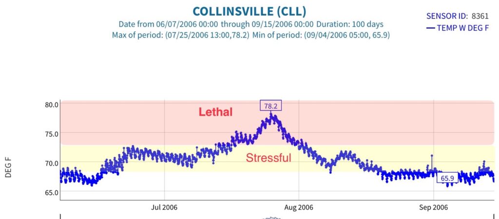
Figure 5. Water temperature (recorded hourly) at Collinsville gage in eastern Suisun Bay in 2006. Stress and lethal levels on Delta Smelt shown in colors.
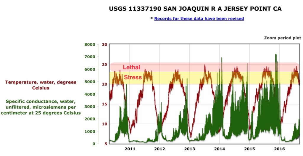
Figure 6. Water temperature and salinity (recorded hourly) at the Jersey Point gage in the west Delta channel of the San Joaquin River 2010-2016. Stress and lethal water temperature levels on Delta Smelt shown in colors. Note the higher summer water temperatures in drought years 2013-2015 and below-normal year 2016, as compared to the 2010-2012 recovery period.
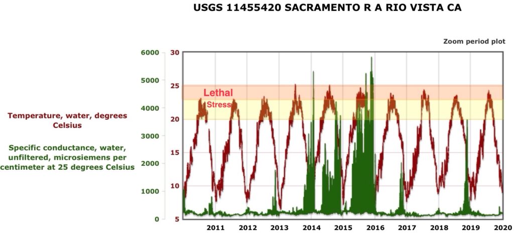
Figure 7. Water temperature and salinity (recorded hourly) at the Rio Vista Bridge gage in the west Delta channel of the Sacramento River from 2010-2019. Stress and lethal water temperature levels on Delta Smelt are shown in colors. Note the higher summer water temperatures in drought years 2013-2015 and below-normal years 2016 and 2018, and wet years 2017 and 2019 than in the 2010-2012 recovery period.
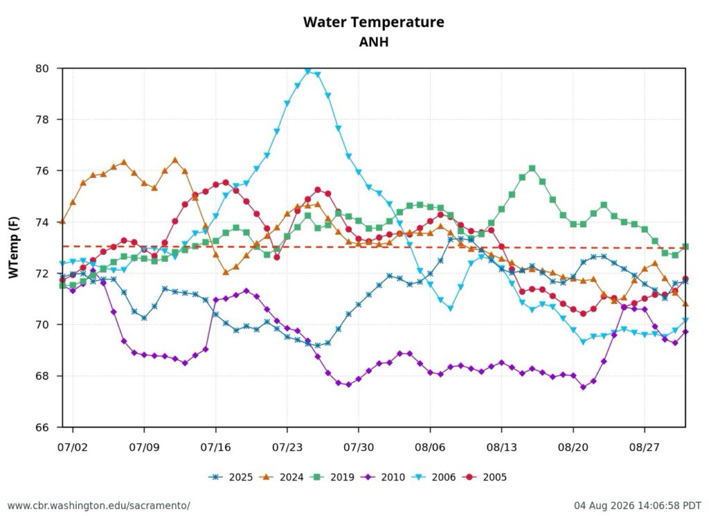
Figure 8. July water temperatures at Antioch gage in western Delta San Joaquin River channel in six normal and wet years including 2010. Note red dotted line of 73ºF above which water temperature is known to be lethal to Delta Smelt in long-term exposure. Note lower water temperatures in 2010, a Delta Smelt recovery year.
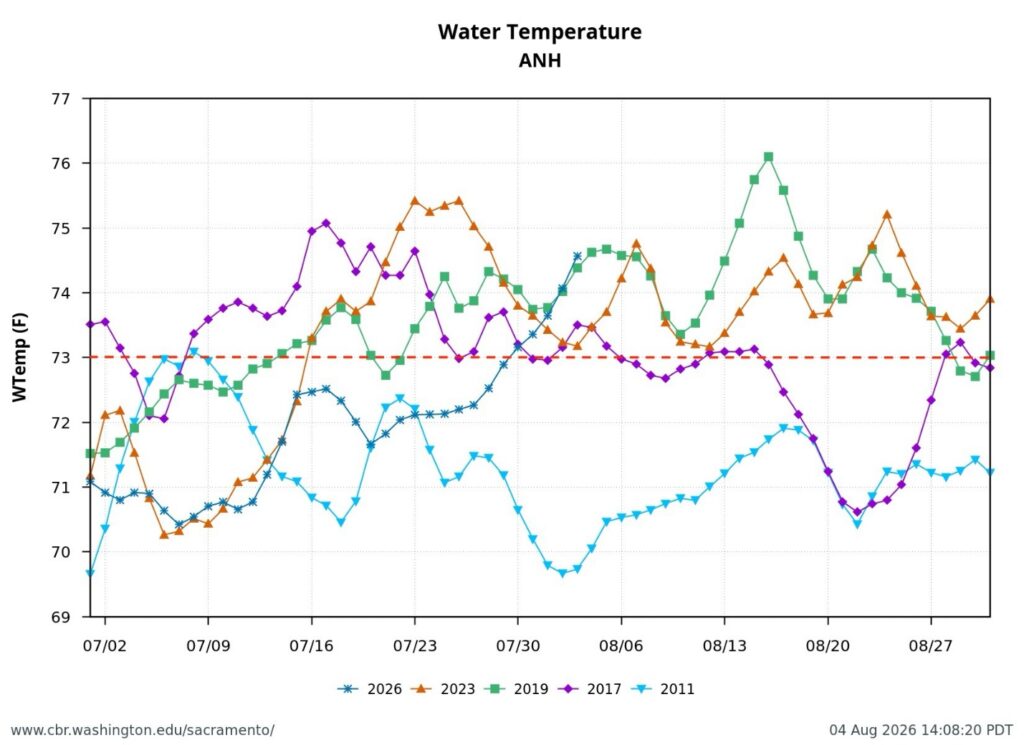
Figure 9. July water temperatures at Antioch gage in western Delta San Joaquin River channel in five normal and wet years including 2011, a Delta Smelt recovery year. Note red dotted line of 73ºF above which water temperature is known to be lethal to Delta Smelt.
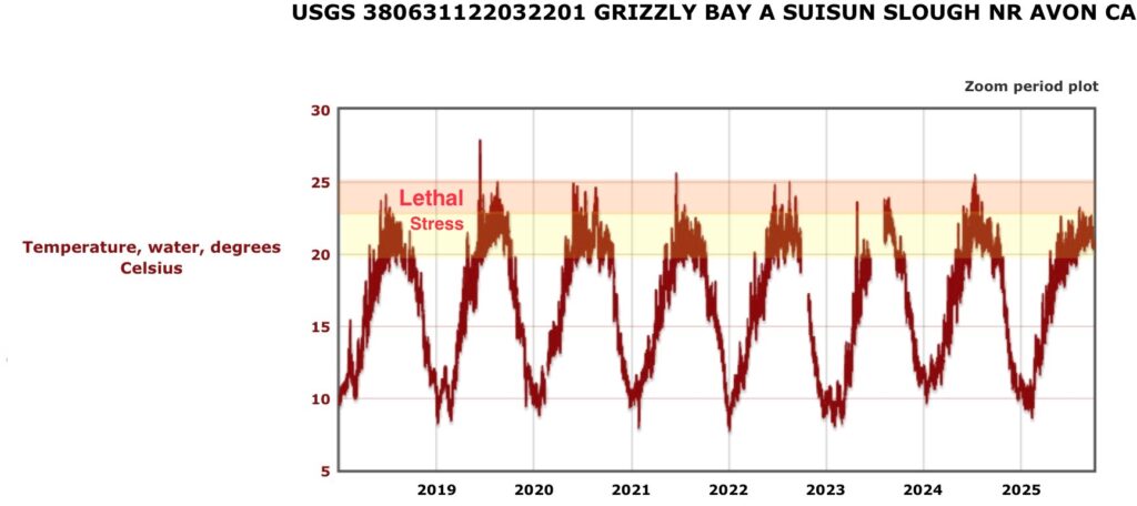
Figure 10. Water temperature (recorded hourly) at the Grizzly Bay gage in the west Suisun Bay 2018-2025. Stress and lethal water temperature levels on Delta Smelt shown in colors. Note the high summer water temperatures in these years except for wet year 2023 and above-normal year 2025.
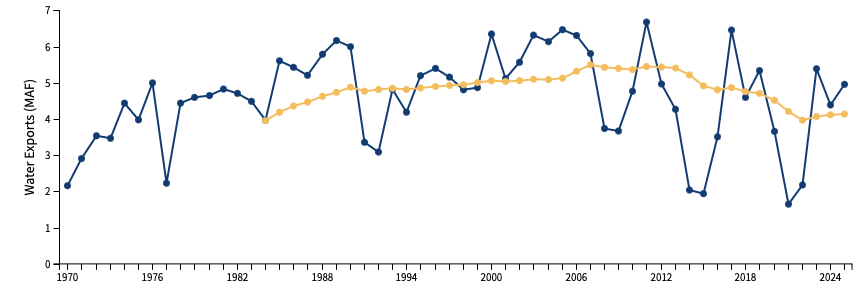
Figure 11. Annual south Delta exports and running average trend line for years 1970-2025.
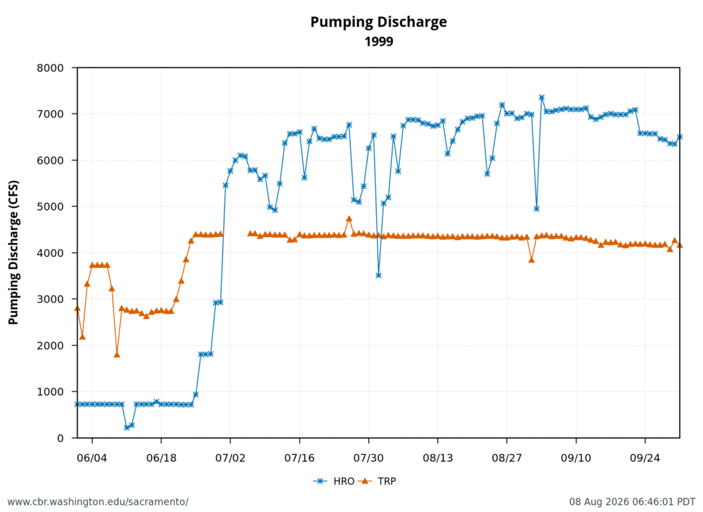
Figure 12. Maximum exports allowed under D-1641 (11,400 cfs) occurred in July 1999. The state Banks Plant (HRO) maximum rate is approximately 7000 cfs. The federal Tracy Plant (TRP) maximum rate is about 4400 cfs. Prior to 1995 the maximum south-Delta export rate was 9000 cfs under D-1485.
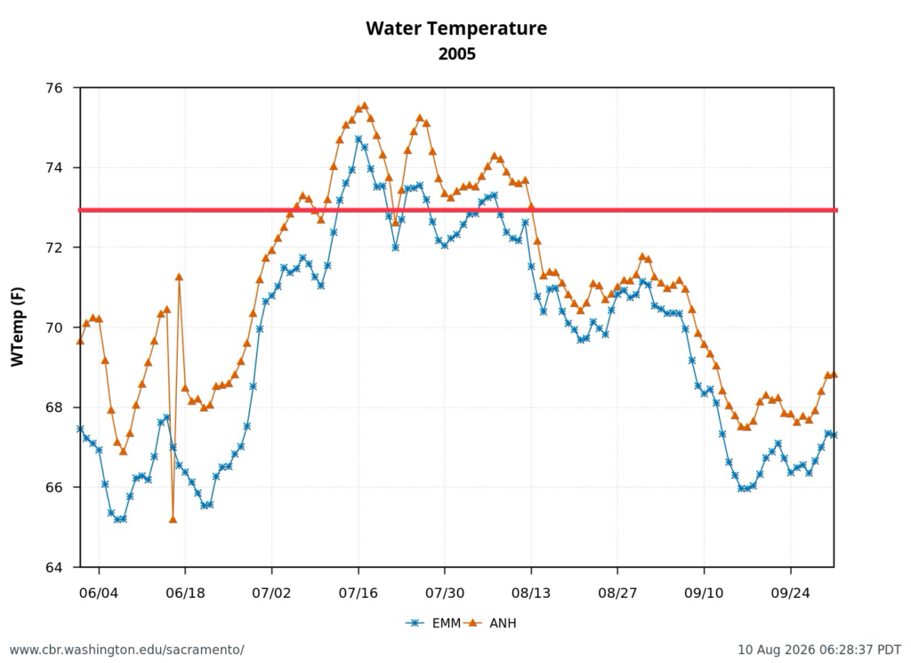
Figure 13. Summer water temperatures at Antioch and Emmaton gages in western Delta in above-normal water year 2005. Note red line at 73F above which is known to be lethal to Delta Smelt.
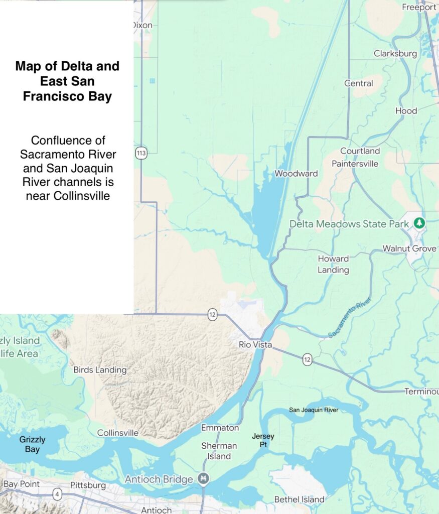
Figure 14. Map of the northern Delta and eastern San Francisco Bay (Suisun Bay)

The Premeditated Murder of Sacramento River Salmon in Summer 2026

The Bureau of Reclamation is systematically emptying Shasta Reservoir of its cold-water-pool reserve this summer. At the current and planned rate of release, Sacramento River winter-run, spring-run, and fall-run salmon broodyears 2026 will not survive the summer and fall.

The process employed by Reclamation is premeditated murder of salmon in response to the Presidential Executive Order 14181. That order requires federal agencies to “override existing activities that unduly burden efforts to maximize water deliveries.”

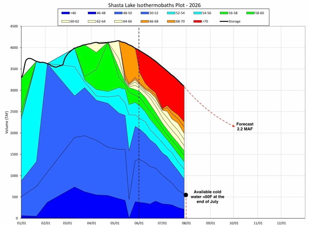
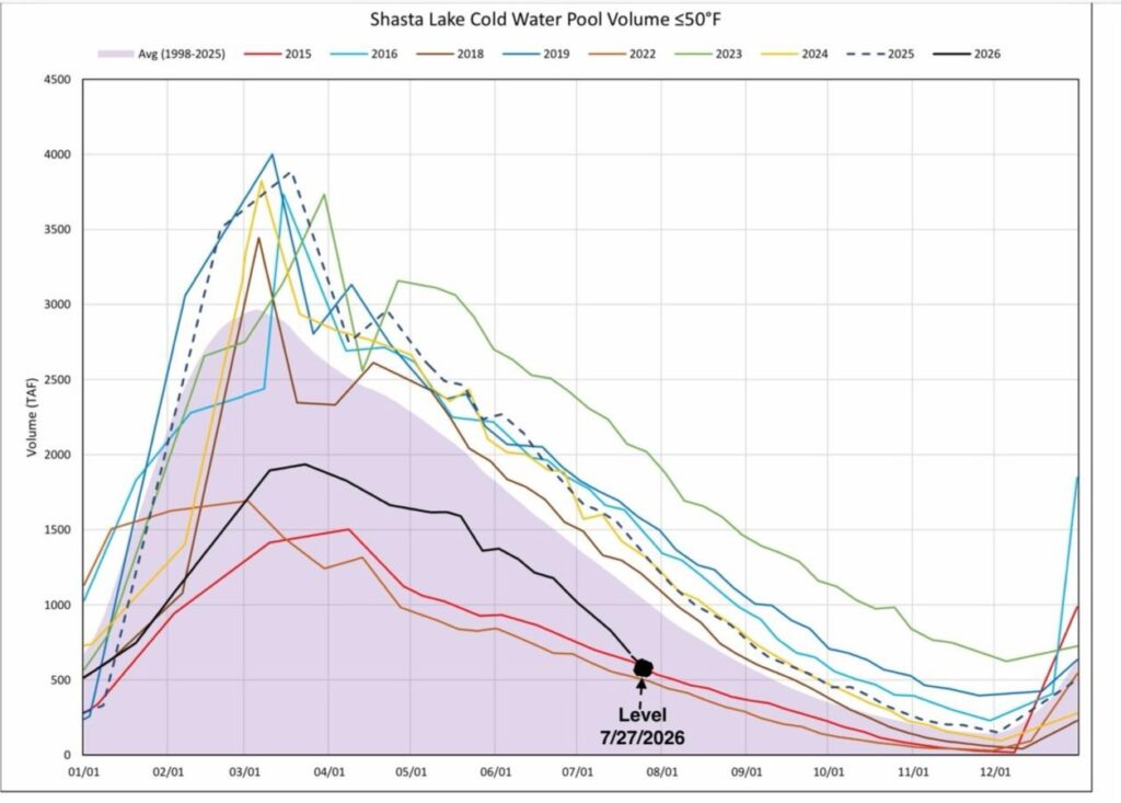
Reclamation’s 2026 Sacramento River Temperature Management Plan (TMP) already contained information that showed Reclamation’s predicted water temperatures for end-of-summer Shasta Reservoir releases to be wildly optimistic. Table 2 of the TMP showed a planned June-August release from Shasta Reservoir of 1.9 million acre-feet. 2 million acre-feet was the amount of cold water in Shasta Reservoir on June 1 (Figure 1 below: black line within second-darkest blue).

Reclamation knew that that the cold-water supply in Shasta was already compromised by poor snowmelt and runoff. Nonetheless, Reclamation released the draft TMP in May. Reclamation ignored concerns from state and federal resource agencies, and proceeded to finalize and implement the TMP.  Reclamation knew, or at the very least should have known, that it could not maintain 53.5ºF at the Clear Creek gage (CCR) and 56ºF at the Balls Ferry gage (BSF) even through August, let alone through September or October, with the planned level of releases from Shasta Reservoir for irrigation deliveries.

Can salmon be saved in 2026?

The CSPA 2021 TMP proposed a 5000 cfs release of 53-54ºF water from Keswick Reservoir, with no Trinity transfer through the Spring Creek Powerhouse, and with minimal daily peaking power production to limit withdrawals of warm water from the surface of Shasta Reservoir.  The approximate 10,000 acre-feet/day CSPA proposed in 2021 is roughly the amount of cool (<52F) water left in Shasta Reservoir on August 1, 2026. That release schedule would sustain relatively cool water in the Sacramento River through October (Figures 1 and 2).  This regime would maintain 54.5ºF at SAC and 56ºF at Clear Creek CCR at the control points through October. Though far from optimal, this would provide some minimal level of survival of broodyear-2026 salmon and provide an end-of-September Shasta storage level near 2.4 million acre-feet, as recommended by the State Water Board.

Figure 1. Shasta Reservoir’s daily isothermobaths (volume of storage) in 2026. Note Reclamation’s TMP EOS 2.2 MAF forecast. Source: sactemprpt-2.pdf.

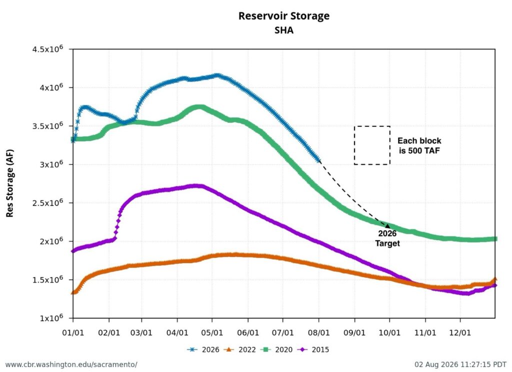
Figure 2. Shasta Lake storage (acre-ft) in drought years 2015 and 2022, below normal 2020, and above normal 2026.

Reclamation Is Not Meeting the 2026 Shasta Temperature Management Plan

The US Bureau of Reclamation is well on its way to failing to adhere to its 2026 Sacramento River Temperature Management Plan (TMP). The cold-water pool supply in Shasta Reservoir has fallen as low on this date in 2026 as it was in critical drought years 2015 and 2022 (Figure 1). Survival of winter-run Chinook salmon in the Sacramento River from brood years 2015 and 2022 was less than 5 percent because the cold-water-pool supply in Shasta Lake was exhausted before the end of summer. Reclamation is again creating similar conditions that threaten this year’s production onf winter-run and fall-run Chinook salmon in the upper Sacramento River below Shasta Reservoir.

The 2026 TMP proposed relaxing the requirements for salmon under the National Marine Fisheries Service’s (NMFS) 2024 LTO Biological Opinion for the Long-Term Operation (LTO) of the Central Valley Project and the State Water Project. Reclamation implemented TMPs under the LTO Biological Opinion in 2024 and 2025. 2024 and 2025 were similar water years that, like 2026, had above-average April storage in Shasta Reservoir. Part of Reclamation’s stated rationale is that 2026 had a low snowpack and thus a smaller cold-water pool in Shasta Reservoir.

Reclamation moved ahead with the 2026 TMP despite not receiving the approval of the State Water Board. The conflict with the Board is mainly over the target end-of-September (EOS) storage in Shasta Reservoir, with Reclamation planning for a 2.2 million acre-feet (MAF). The “Shasta Framework” in the LTO Biological Opinion calls for EOS Shasta storage of 2.4 MAF.

Also at issue is Reclamation’s ability to fulfill the TMP’s commitment to maintain a water temperature of 53.5°F at the Clear Creek gage near Redding through October 31 to protect salmon reproduction. Reclamation has achieved that temperature through July. A cooler than normal spring helped sustain the cold-water-pool supply. However, Reclamation is rapidly using up the cold-water pool by meeting high contractor water demands, by using cold water from Shasta to offset the import of warm Trinity-Whiskeytown water (about 15-20% of total Keswick Dam releases to the upper Sacramento River), and by maximizing peaking-power production at Shasta Dam.

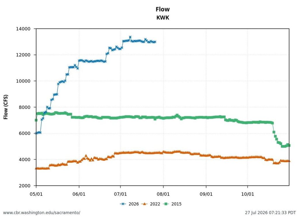
Keswick Dam releases in July are a steady 13,000 cfs, providing approximately 6,000 cfs of contractor demands and 7,000 cfs flows and 68°F target water temperatures in the lower Sacramento River (at Wilkins Slough gage above the mouth of Feather River). At that rate, EOS Shasta storage of even 2.2 MAF will be difficult to achieve without exceeding agreed-to water temperature conditions. Reclamation will prematurely exhaust Shasta’s cold-water pool (Figure 1). Target water temperatures in the lower Sacramento River will be exceeded, as in past years.

Comparison of 2026 with Water Years 2024 and 2025, and Drought Year 2022

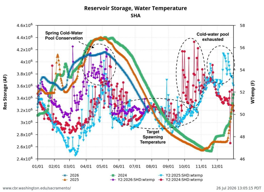
At the beginning of spring 2026, there was less snowmelt and a smaller cold-water-pool volume in Shasta Reservoir than there had been in 2024 and 2025 (Figure 2). The spring cold-water-pool conservation period was warmer, but the cold-water release target nevertheless started promptly on May 15. It will continue through October 31, unless the cold-water pool is depleted in September or October, as occurred in 2024.

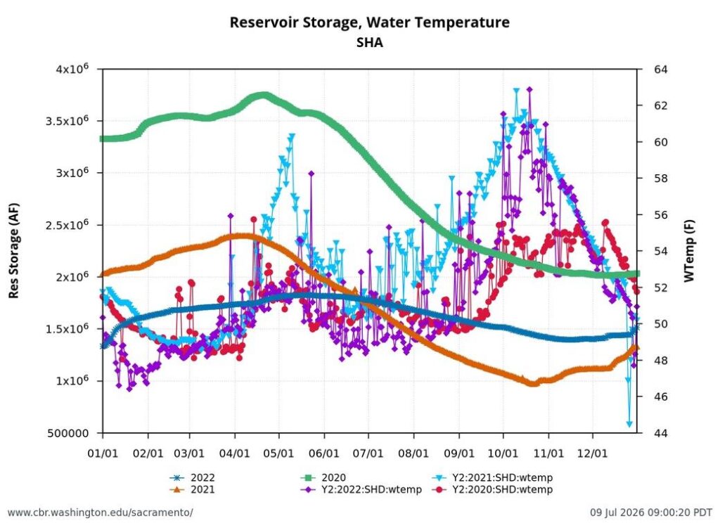
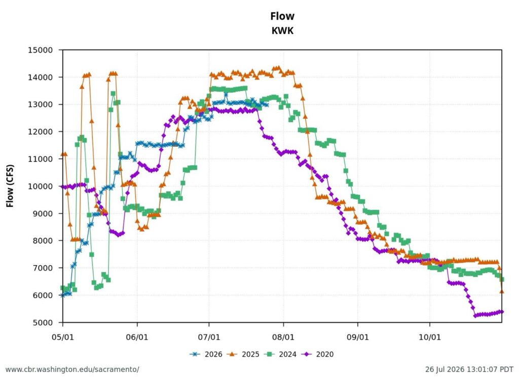
Reclamation’s 2026 TMP is comparable to water year 2020 TMP, a dry water year (Figure 3). In 2020, the EOS storage was close to the 2.2 MAF target, but Reclamation failed to preserve the cold-water pool. Beginning in September and lasting through November, Reclamation released water from Keswick Dam that exceeded the temperature target in the 2020 TMP. The failure to sustain the cold-water supply increased mortality during the spawning and early incubation season of the winter-run salmon (September-October) and fall-run salmon (October-November).

Summary

In 2026, Reclamation must at minimum immediately revise its TMP to include the following criteria:

  • Reclamation must revise its present plan for contractor water deliveries. Otherwise, Reclamation will not meet temperature requirements to protect the salmon through the end of the irrigation season and beyond. Reclamation will have to reduce water deliveries to the 2020 levels or less to save the cold-water-pool supply and meet temperature criteria (Figure 4). The cold-water-pool supply in late July is at the drought year 2015 and 2022 level (see Figure 1), yet the Shasta Dam cold-water release is triple the 2022 level and double the 2015 level (Figure 5).
  • Reclamation must maintain water temperatures at a maximum of 53.5°F and 56°F at the Clear Creek and Balls Ferry gages, respectively, through October.
  • Reclamation must maintain maximum water temperatures of 68oF at the Wilkins Slough gage in the lower Sacramento River.
  • Reclamation must meet a target Shasta Reservoir EOS storage of 2.4 MAF.

Figure 1.

Figure 2. Shasta Reservoir storage and release temperature 2024-2026 with annotations.

Figure 3. Shasta Reservoir storage and release temperature 2020-2022 with annotations.

Figure 4. Keswick Dam releases (cfs) May-Oct 2020 and 2024-2026.

Figure 5. Daily average flow release (cfs) from Keswick Dam May-Oct 2015, 2022, and 2026.

June 2026 – Reclamation’s Approach to Compliance with Sacramento River Water Quality Standards and Permit Requirements

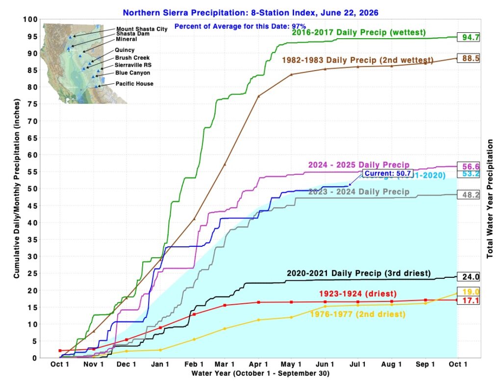
Water year 2026 is an average or normal year in terms of total precipitation, similar to 2024 and 2025 (Figure 1).

On April 29, 2026, the Bureau of Reclamation sent a Draft Sacramento River Temperature Management Plan (TMP) to the State Water Resources Control Board (State Board) for review. The Draft TMP stated that it would manage Shasta Reservoir (near Redding) in 2026 according to a drier-year standard than the amount of actual storage in Shasta Reservoir required on paper. The requirement is given in the National Marine Fisheries Service’s 2024 Biological Opinion for the Long-Term Operation of the Central Valley Project and State Water Project (LTO).

Reclamation explained that it based its classification of 2026 on the “Action 5” Operations Plan for the LTO. Action 5 is Reclamation’s modification of the 2024 LTO Biological Opinion. Reclamation adopted Action 5 in December 2025 to comply with a January 2025 presidential order to increase water deliveries.

The Draft TMP also proposed locations on the Sacramento River where Reclamation would meet water temperatures to support spawning and egg incubation of winter-run Chinook salmon. June is the peak spawning season for winter-run salmon below Shasta Dam.

The State Board responded to Reclamation on May 15, 2026 with a comment letter on the Draft TMP.  The State Board’s comments requested additional analyses, including reduced deliveries and increased end-of-September storage in Shasta Reservoir.  On June 1, 2026, Reclamation issued a Final TMP whose proposed operations were functionally the same as those that Reclamation proposed in the Draft TMP.

On June 10, 2026, the Executive Director of the State Board sent a response to the Final TMP to Reclamation “objecting to the final TMP as per the language in Water Rights Order 90-5.” However, the Executive Director’s response does not specify any specific actions the State Board will take against Reclamation. Instead, it requires Reclamation to meet 53.5ºF in the Sacramento River at Clear Creek (River Mile or RM 290) through the summer and to report to the State Board when water temperatures do not meet 56ºF at Balls Ferry (RM 276). 53.5ºF in the Sacramento River at its confluence with Clear Creek provides about ten miles of river with water cold enough for salmon eggs.

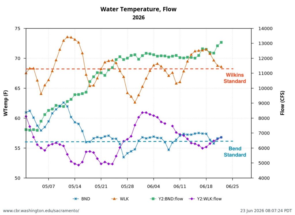
In June 2026, Reclamation released water from Shasta Reservoir to maintain Sacramento River temperatures at 56ºF at Bend Bridge (RM 258). Also in June, Reclamation released enough water to deliver approximately 6000 cubic feet per second (cfs) of water to its contractors along the Sacramento River (Figure 2).

The State Board’s main problem with Reclamation’s TMP is the high amount of Shasta releases (approximately 12,000 cfs, or 24,000 acre-feet per day) to meet both the temperature standards and contractor demands. Those releases are expected to increase in July. In combination, this level of release could deplete Shasta’s cold-water pool before the end of the salmon spawning and incubation season.

The Board is concerned because prior-year TMPs failed to maintain Shasta’s cold-water pool through the salmon spawning seasons (Figure 3 and 4). Spawning success of fall-run salmon and winter-run salmon was compromised in past years with relatively average precipitation.

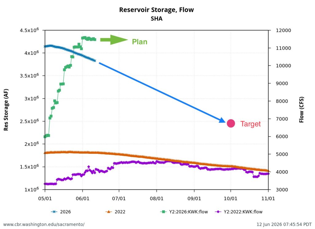
The challenge is to make sure there’s enough water for all uses through autumn. The State Board wants a plan that targets 2.4 million acre-feet of storage in Shasta Reservoir at the end of September, as shown in Figure 5. This is the amount shown on paper in the Biological Opinion that governs Shasta Reservoir. It is unclear how, even with Reclamation’s “Action 5” modification of the Biological Opinion, Reclamation arrived at its proposed lower end-of-September storage level.

Achievement of end-of-September Shasta storage of 2.4 million acre-feet could mean cutting back on scheduled water deliveries or finding a balance with river flows and water temperature goals.

Other possibilities to reduce summer and autumn water temperatures in the Sacramento River include adjusting the timing and volume of water Reclamation imports from the Trinity River to the Sacramento River through Whiskeytown Reservoir. They also include modifying Reclamation’s hydropower operations at Shasta Dam; Reclamation’s turbines sometimes draw water from relatively warm parts of Shasta Reservoir.

Figure 1. Eight-River Index in June 2026 compared to past years. Source: CDEC.

Figure 2. From May 1 through mid-June 2026, Reclamation did not meet water temperature standards in the upper Sacramento River at the Bend Bridge (BND) or in the lower Sacramento River below Wilkins Slough (WLK). In mid-May and mid-June, Reclamation was delivering about 6000 cfs to contractors from the Sacramento River upstream of Wilkins Slough.

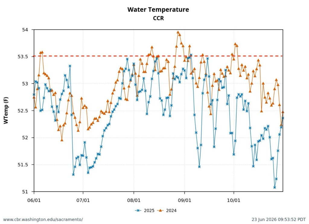
Figure 3. Sacramento River water temperature at Clear Creek gage near Redding June through October 2024 and 2025. Dotted red line is water temperature target of temperature management plans in 2024 and 2025.

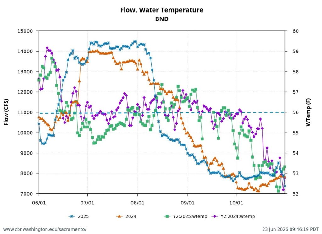
Figure 4. Sacramento River water temperature and streamflow at Bend Bridge gage near Red Bluff June through October 2024 and 2025. Dotted blue line is water quality standard and permit requirement for water temperature. Note general lack of compliance in June, August, and September of both years. Note also drops in flow from14,000 to 8,000 cfs over the summer can lead to winter run salmon redd dewatering and winter-run egg and alevin mortality.

Figure 5. Shasta Reservoir water storage and releases in drought year 2022 and average year 2026. The State Board wants a Temperature Management Plan from Reclamation that meets a target end-of-September storage of 2.4 million acre-feet.

May 2026 Blue Moon contributes to Poor Bay-Delta Habitat Conditions

This post is a follow-up to a prior post on early spring conditions in the Bay-Delta in 2026.

May 2026 featured five primary lunar phases, including two full moons. The first full moon (Flower Moon) peaked on May 1, followed by the third quarter on May 9, a super new moon on May 16, and the first quarter on May 23. The month closed with a second full moon (a micro blue moon) on May 31.

These phases of the moon worsened the consequences, for fish and water quality, of water operations by the Bureau of Reclamation.

First, the poor May Delta habitat conditions resulted from low Delta inflow – unusually low Sacramento River inflows to the Delta at Freeport (Figure 1). The low inflow, in conjunction with a late spring heatwave, led to high north Delta water temperatures (Figure 2).

Second, low Sacramento River flows and high water temperatures upstream of the Delta (Figure 3) also contributed to the poor Delta conditions.  Water temperature at Wilkins Slough reached daily-average 74oF mid-month, six degrees above the water quality standard, under flows less than 5000 cfs.

Third, the mid-month super new moon and end-of-month blue moon contributed to the higher river channel stages (Figures 4 and 5) in the north Delta that pooled the warm freshwater inflows and contributed to further warming during the late May “heatwave”.

Fourth, a consequence of the warming in the north Delta was warming in the west Delta (Emmaton, Figure 6) and eastern Suisun Bay (Collinsville, Figure 7).

The poor habitat conditions caused significant stress on late immigrating winter-run and spring-run adult salmon and late emigrating salmon smolts. The poor conditions also reduced the likelihood of successful reproduction for sturgeon and smelt..

The suboptimal habitat conditions observed in the lower Sacramento River, Delta, and Bay were preventable. The Bureau of Reclamation could have mitigated these conditions by maintaining Sacramento River flows within a 7,000–10,000 cfs range, north Delta Freeport flows between 15,000–20,000 cfs, and Rio Vista daily-average flow and Delta outflow at approximately 10,000 cfs (Figure 8).

An added 3,000–5,000 cfs (6,000–10,000 acre-feet per day) flow was needed in late May 2026 to avoid the poor conditions. That amount is approximately 2 to 3 percent of Sacramento Valley water project reservoir end-of-April storage, or about a quarter to a third of May water contractor deliveries.

On paper, Reclamation must manage the flows necessary to comply with water quality standards, water right permit requirements, and endangered species take permits. However, Reclamation’s adherence to these regulations has diminished significantly over the past twenty years.

More recently, Reclamation’s operations have become substantively worse for fish under its “Action 5” interpretation of the Biological Opinion for the Central Valley Project. Reclamation adopted Action 5 in December 2025, in response to the Presidential  Executive Order 14181 that requires federal agencies to “override existing activities that unduly burden efforts to maximize water deliveries.”

Figure 1. May 2026 Sacramento River hourly Delta inflow at Freeport gage. Also shown in daily average for prior 67 years. Data source: USGS.

Figure 2. May 2026 air and water temperatures in the Sacramento River channel of the north Delta at Freeport (FPT), below the entrance to Georgianna Slough (GES), and the Rio Vista Bridge (RVB). Data source: CDEC. See map for locations.

Figure 3. Sacramento River flow and water temperatures in May 2026 at Keswick (KWK), Bend (BND), Colusa (COL), and Wilkins Slough (WLK). Note the difference between upper and lower river flow is from 4000-5000 cfs, due to water contractor deliveries.

Figure 4. May 2026 Delta outflow (DTO) and average-daily river stage (water surface elevation) at the Rio Vista Bridge (RVB) and Jersey Point (SJJ). See map below for stage locations. Note mid-May decline in outflow and increase in stage occurred as a result seasonal tide changes – the result of the mid-May super new moon and the end-of-May blue moon.

Figure 5. Hourly tide stage at Rio Vista Bridge gage in April-May 2026. Note peak stage (water surface elevations) were about ten days before the two May full moons (1st and 30th).

Figure 6. Sacramento River channel hourly water temperature at the Emmaton gage in May 2026.

Figure 7. Sacramento River channel hourly water temperature at the Collinsville gage in eastern Suisun Bay in May 2026.

Figure 8. Daily average (tidally filtered) streamflow at the Rio Vista Bridge in May 2026.

Map of North Delta and Sacramento River Channel