“Epic” Salmon Fishing this Summer

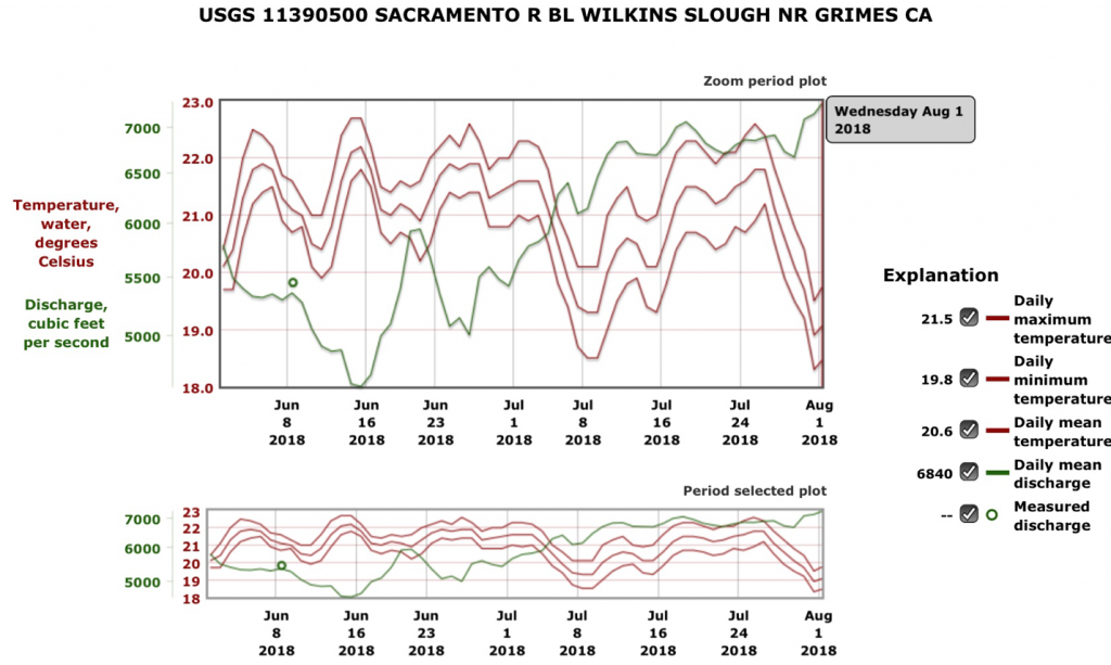
Reports on the July 15 opener on the lower Sacramento fall-run salmon season are good.1 Reclamation and Sacramento River farmers have provided the flows needed to keep water temperatures down (Figure 1), allowing what appears to be a good run up the river from the Golden Gate. Openers in recent years have been poor because of low flows and high water temperatures, as well as low salmon numbers. Numbers are up, and water temperatures are down – good for fishing.

Figure 1. Higher flows in July have cooled the river despite many 100+ degree days. Source.

Winter-Run Salmon Status – 2018

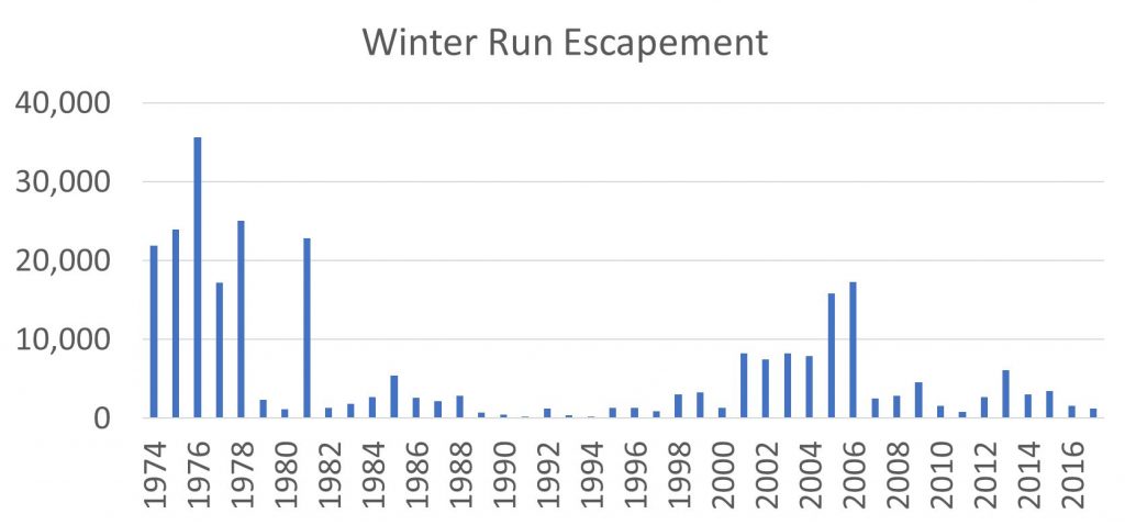
In a March 14 post, I discussed the primary factor in the initial decline of Sacramento River winter-run salmon in the early 1980s (Figure 1) – higher south Delta exports in drier years after the State Water Project came on line in the 1970s.   In a January 15, 2017 post, I discussed the causes of the recruitment failures from poor egg survival in spawning grounds in summers of 2014 and 2015.  In this post, I suggest that recruitment into the population and long-term population declines stems from fewer spawners (eggs produced) over time and low Sacramento River flows (Shasta Reservoir releases) in fall and winter.

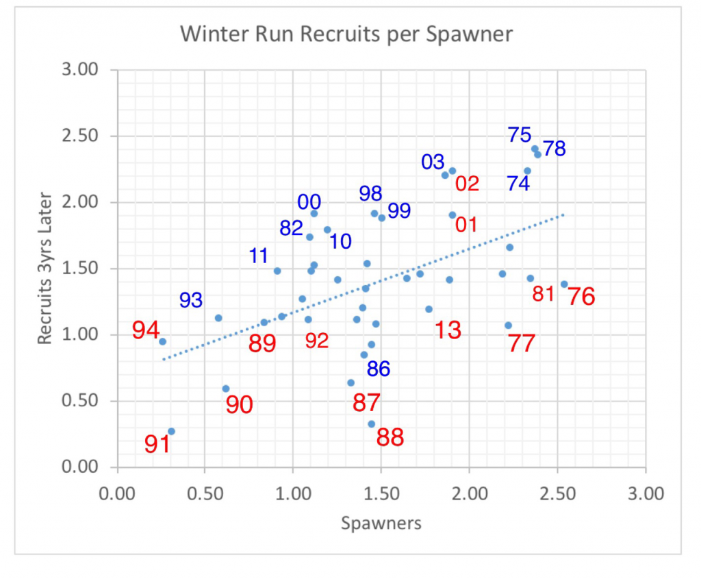
The spawner-recruit relationship (Figure 2) depicts a strong positive effect of the number of spawners on the number of recruits into the population.  This is important because mortality reduces the number of spawners and also the subsequent years’ egg production – a double whammy.  Without mitigation, the population spirals toward extinction.

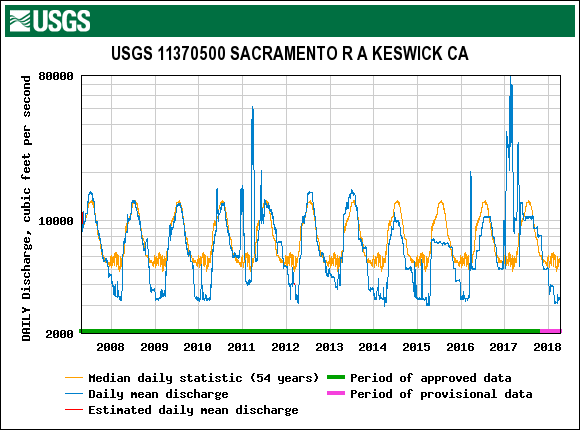
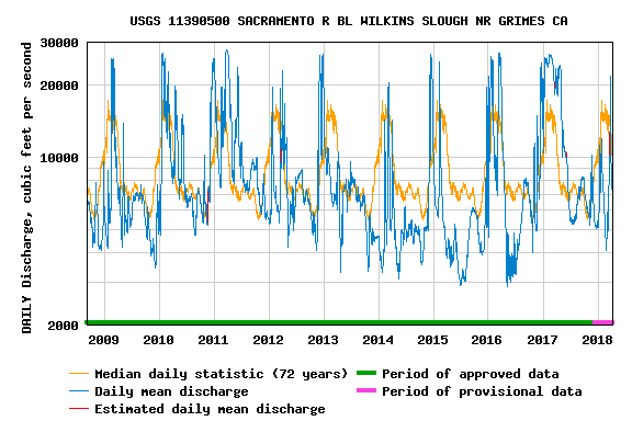
In addition, the relationship suggests that ten times as many salmon are produced in wetter years as in dry years for the same level of spawners.  Over the past decade, drier years have lower fall and winter river flows in the upper river spawning and early rearing reach (Figure 3), and lower winter flows in the lower river rearing and migratory reach (Figure 4).  The lower fall-winter flows reduce the productive capacity and survival of young salmon in the upper river spawning-rearing reach.  The low winter flows in the lower river reduce transport and survival on the way to and through the Delta.

The road to recovery is to build up the number of spawners by providing better flows in fall and winter, and to ensure eggs are sustained by cold-water Shasta Reservoir releases through the summer.  Hatchery augmentation helps sustain existing low levels of adult spawners in the population; otherwise the population would decline toward extinction in fewer generations.

Figure 1. Spawning population estimates of adult winter-run salmon in the upper Sacramento River from 1974 to 2017. Source: CDFW.

Figure 2. Spawner-recruit (log-log) relationship for the winter-run salmon population in the Sacramento River. The number is the brood year. For example: 1991 depicts the recruits derived from 1991 spawners. Red represents drier years, and blue represents wetter years for the brood year’s first summer and fall. For example: 1991 was a dry year.

Figure 3. Daily average Sacramento River flow below Keswick Dam, 2007-2018. The 54-year average median daily flow is also shown. Source: USGS.

Figure 4. Daily average lower Sacramento River flow at Wilkins Slough, 2008-2018. The 54-year average median daily flow is also shown. Source: USGS.

More on Sacramento River Salmon Declines Reclamation did what it had to do in water years 2010 to 2012, but not in 2016-2018.

With poor salmon runs from 2009 to 2011, Reclamation provided good conditions in the lower Sacramento River below Shasta Reservoir in spring-summers of 2010 to 2012 for fall-run and winter-run salmon. That effort contributed to recovery of fall-run salmon from the 2007-2009 drought in 2012-2014 (Figure 1). The sequence of below-normal, wet, and below-normal water years (2010-2012) provided sufficient water for good smolt survival, overcoming a significant deficit of adult spawners (eggs spawned). Poor conditions in the subsequent drought of 2013-2015 led to the latest fall-run collapse in 2016-2017.1

So did Reclamation provide good spring-summer conditions in the lower Sacramento River in below-normal, wet, below-normal water year sequence 2016-2018 to help recovery from the latest drought? No. As a result, we can now expect poor runs in 2019 and 2020 instead of a recovery.

2010-2012

Reclamation made a concerted effort in 2010-2012 to meet water temperature objectives in the upper river near Red Bluff (Bend, Balls Ferry, and Red Bluff) and the lower river near Sacramento (Wilkins Slough, Verona). The 56°F and 68°F water temperature objectives for the upper and lower river, respectively, were regularly met (Figures 2-4) in spring and summer.

2016-2018

In a less than concerted effort in 2016-2018, Reclamation has failed to meet the water temperature objectives more often and with greater discrepancies (Figures 5-7). More detail on the failure is provided in a recent post.

Problem and Solution

The causal factor is simply lower flows in spring and summer 2016-2018 than 2010-2012 (Figure 8). Lower flows, higher water temperatures, and lower turbidities lead to poor salmon smolt survival (and low adult migrant survival and subsequent egg viability). A concerted effort to recover salmon would mean maintaining water temperature objectives with spring-summer flows in the lower river at Wilkins Slough in the 7000-8000 cfs range instead of the 5000-6000 cfs range (Figure 8). This may require a supplemental release from Shasta Reservoir as in 2012 (Figure 9), which amounted to nearly 200,000 acre-ft of storage release, so that storage ended at 2,600,000 acre-ft at the end of September. The target end-of-September storage in below-normal water year 2018 is 2,300,000 acre-ft. With water deliveries near 2 million acre-ft from the Sacramento River in 2012 and 2018, a “concerted effort” involving 200 thousand acre-ft to maintain water temperature objectives prescribed in the water right permits seems reasonable. Whether it comes from Shasta storage or water contractor deliveries is a management/permitting agency decision.
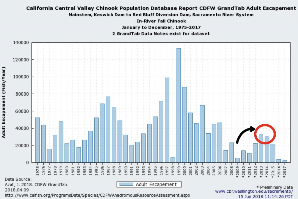
Figure 1. Long-term trend in upper Sacramento River fall-run salmon escapement. Red circle denotes recovery from low escapement from 2007-2009 drought.

Figure 2. Water temperature in the upper (Red Bluff, Balls Ferry) and lower Sacramento River (Verona) in 2010. Top red line denotes objective for lower river (68°F); bottom line denotes objective for upper river (56°F). Red circle denotes excessive temperatures. In 2010, a below-normal water year following three years of drought had water temperatures near objectives.
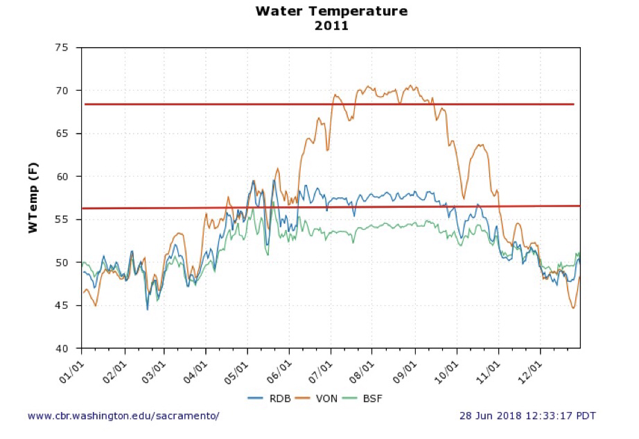
Figure 3. Water temperature in the upper (Red Bluff, Balls Ferry) and lower Sacramento River (Verona) in 2011. Top red line denotes objective for lower river (68°F); bottom line denotes objective for upper river (56°F). In 2011, a wet water year had water temperatures near objectives.
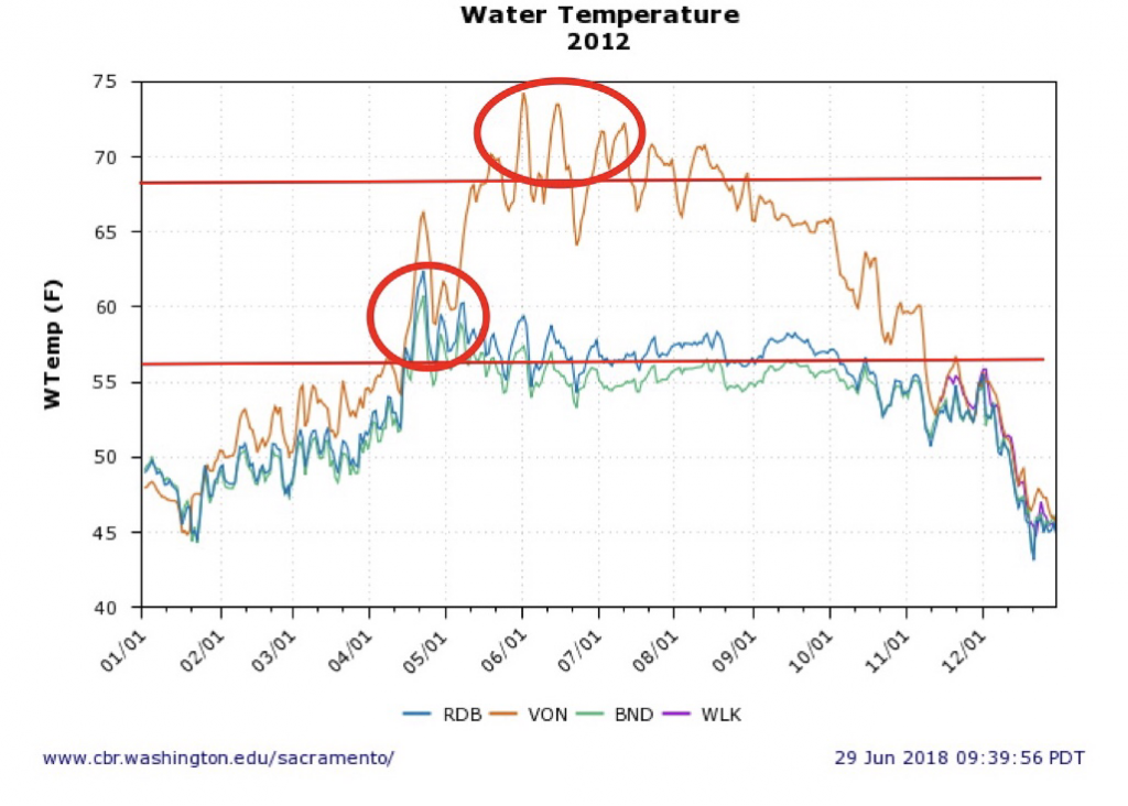
Figure 4. Water temperature in the upper (Red Bluff, Balls Ferry) and lower Sacramento River (Verona) in 2012. Top red line denotes objective for lower river (68°F); bottom line denotes objective for upper river (56°F). Red circles denote excessive temperatures. In 2012, a below-normal water year following a wet year had water temperatures near objectives.
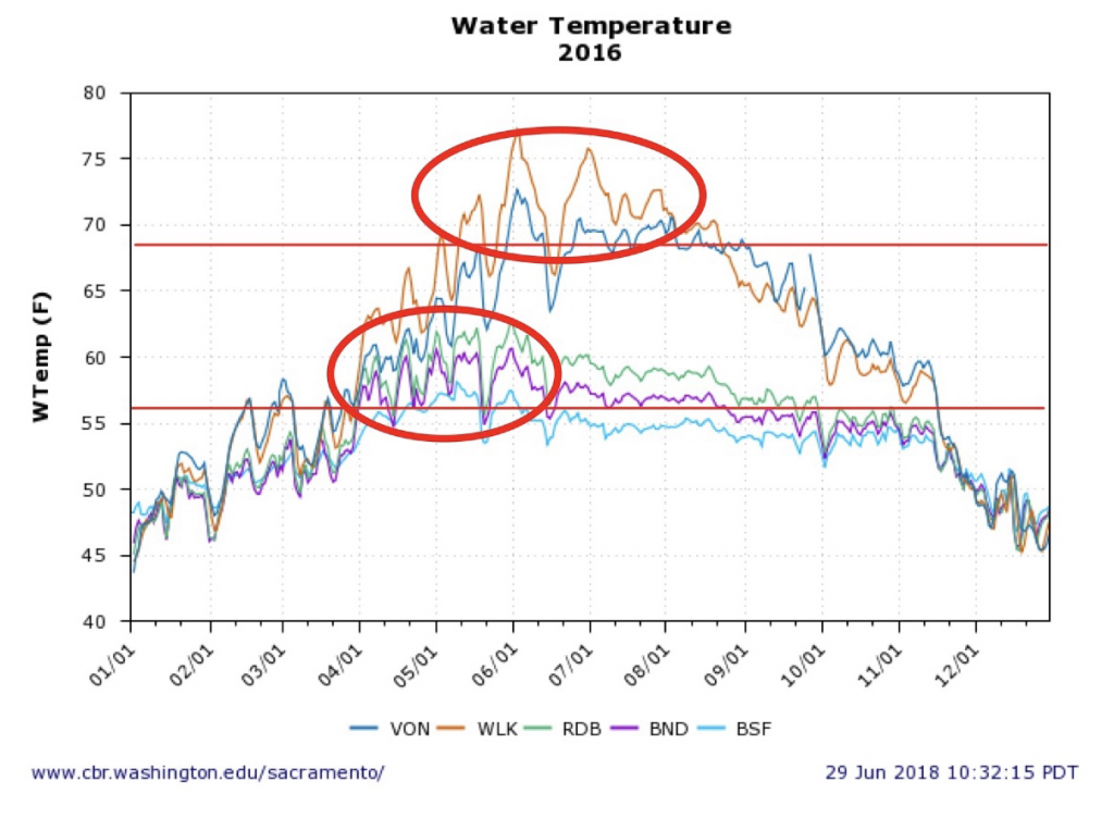
Figure 5. Water temperature in the upper (Red Bluff, Bend, Balls Ferry) and lower Sacramento River (Wilkins Slough, Verona) in 2016. Top red line denotes objective for lower river (68°F); bottom line denotes objective for upper river (56°F). Red circles denote excessive temperatures. In 2016, a below-normal water year following three drought years had water temperatures exceeding objectives April through July.
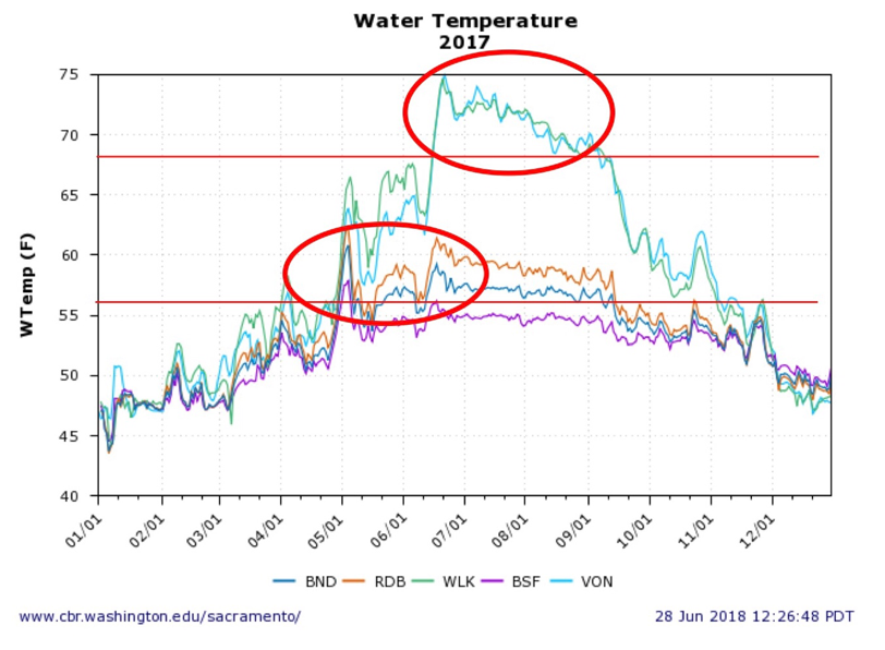
Figure 6. Water temperature in the upper (Red Bluff, Bend, Balls Ferry) and lower Sacramento River (Wilkins Slough, Verona) in 2017. Top red line denotes objective for lower river (68°F); bottom line denotes objective for upper river (56°F). Red circles denote excessive temperatures. In 2017, a wet water year had water temperatures exceeding objectives May through August.
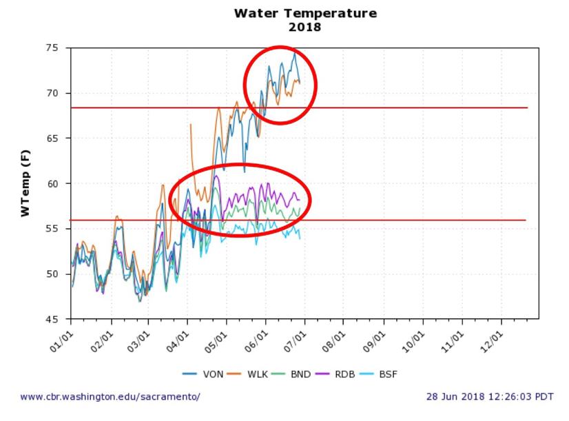
Figure 7. Water temperature in the upper (Red Bluff, Bend, Balls Ferry) and lower Sacramento River (Wilkins Slough, Verona) in 2018. Top red line denotes objective for lower river (68°F); bottom line denotes objective for upper river (56°F). Red circles denote excessive temperatures. In 2018, a below-normal water year following three drought years had water temperatures exceeding objectives April through June.
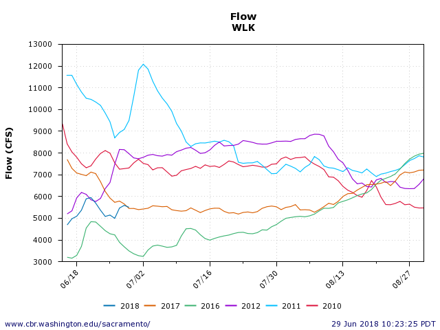
Figure 8. Summer flow in the lower Sacramento River (Wilkins Slough) in 2010-2012 and 2016-2018.
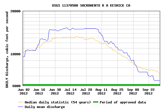
Figure 9. Releases of water from Keswick Reservoir to the lower Sacramento River in 2012 compared to 54 year average.
Enhancing Pelagic Habitat Productivity in the North Delta Is it too late to save the Delta smelt?

The Bureau of Reclamation recently released an Environmental Assessment for the Sacramento Deep Water Ship Channel Nutrient Enrichment Project. The proposed project would directly release nitrogen nutrients into the Ship Channel, which runs from West Sacramento to Cache Slough, north of Rio Vista.  The project is designed to stimulate plankton blooms in the North Delta as part of the Delta Smelt Resilience Strategy, which describes the goal as follows:

The purpose is to determine if the addition of nitrogen can stimulate plankton (fish food organisms) production in a section of the ship channel, which is isolated from the Delta in terms of water flow.

Adding nitrogen to the ship channel will indeed stimulate plankton productivity.  Only a few miles away, regional governments have spent decades in removing nitrogen (most recently, ammonia) from the effluent of the Sacramento Regional Wastewater Treatment Plant to reduce production of blue-green algae in the Delta.  The City of West Sacramento already seasonally releases high nutrients, metals, and salts into the Ship Channel.  Adding more nitrogen could easily increase toxic blue-green algae problems in the Delta, similar to the bloom that recently led to the recreational closure of southern California’s Diamond Valley Reservoir, which receives Delta water.

There is higher plankton productivity in the Ship Channel than in nearby Delta channels because the Ship Channel has longer residence time, higher nutrients,  and higher water temperatures.  The broken gate on the Ship Channel’s northern entrance contributes to these conditions.  However, lack of circulation also leads to nitrogen depletion and declining plankton production, and there is limited seasonal replenishment of nitrogen.

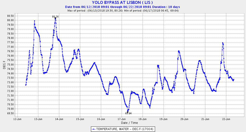
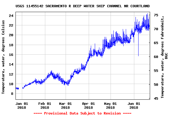
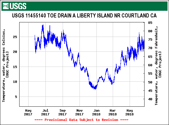
The Delta Smelt Resilience Strategy is considering increasing flows into the north Delta from the Colusa Basin Drain, Fremont Weir, and the Ship Channel to stimulate Delta plankton blooms.  The biggest problem with these sources is high spring-through-fall water temperatures (Figures 1-3).  Water temperature is certainly the greatest limiting factor in the north Delta for Delta smelt; adding nitrogen will not fix this problem.

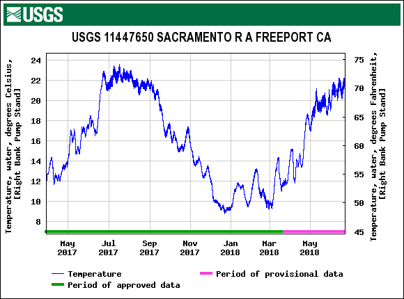
Fixing the gate at the north end and allowing cooler Sacramento River water (strong American River influence) into the channel (Figure 4) would reduce water temperatures in the Ship Channel.  Just a few degrees can be life or death for Delta smelt.  Increased entry into the Ship Channel of Sacramento River water would also introduce more nitrogen, potentially reducing the need to fertilize the Ship Channel with crop dusters.

Figure 1. Water temperature in the Yolo Bypass downstream of the entrance of the Colusa Basin Drain.

Figure 2. Water temperature in the Sacramento River Deep Water Ship Channel.

Figure 3. Water temperature in the lower Yolo Bypass toe drain canal near Liberty Island.

Figure 4. Water temperature in the Sacramento River near Freeport downstream of the entrance to the Sacramento River Deep Water Shipp Channel.

Gross Violation of Water Quality Standards for Water Temperature in Lower Sacramento River Further Degradation of Salmon Habitat

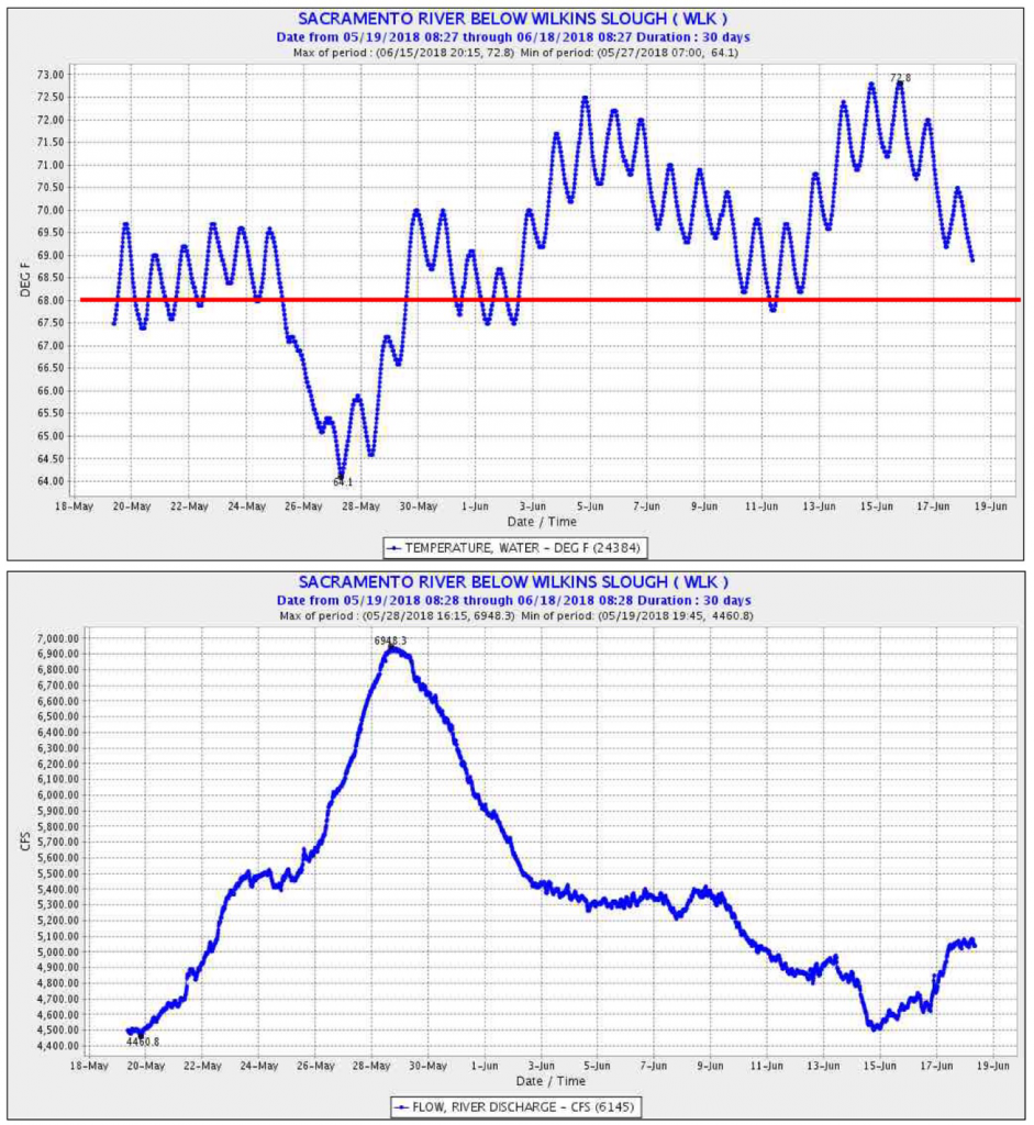
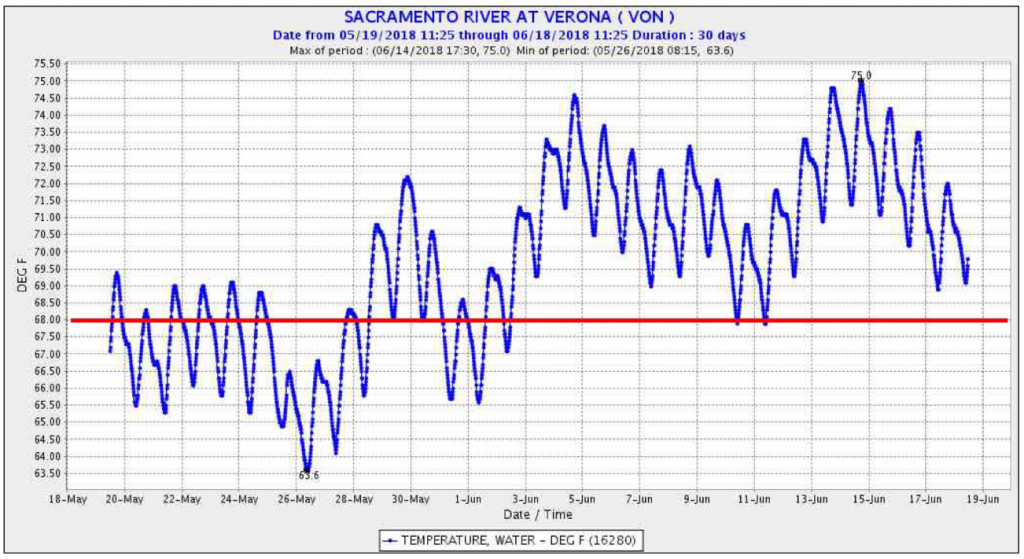
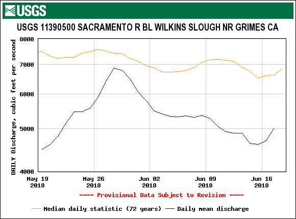
Water temperatures in the lower Sacramento River over the past month have often exceeded water quality standards that protect salmon and other beneficial uses (Figures 1 and 2).  Water temperatures at or above the standard of 68oF adversely affect adult and juvenile salmon.  Water temperatures can meet the standard if the Bureau of Reclamation maintains flow in the Sacramento at Wilkins Slough at 6000-8000 cfs, depending on air temperature.  The Bureau of Reclamation has maintained such flows in the past to meet water quality standards and terms in its water rights permits (Figure 3).  Shasta Reservoir water storage is 102% of normal as of June 18, 2018.  Water diversions from the Sacramento River upstream of Wilkins Slough are approximately 6,000 cfs, with 100% allocation to CVP contractors under water right permits.  For more on the effects on salmon, see past posts.

Figure 1. Sacramento River flow and water temperature at Wilkins Slough in lower Sacramento River: mid-May to mid-June 2018. Red line denotes water quality standard. Source: CDEC.

Figure 2. Sacramento River water temperature at Verona in lower Sacramento River: mid-May to mid-June 2018. Red line denotes water quality standard. Source: CDEC.

Figure 3. Historical and recent flow at Wilkins Slough. Source: USGS.