
Big Springs contributes streamflow, cold water, and volcanic nutrients to the middle and lower Shasta River. Although its contribution to the overall volume of the Klamath River is small (Figure 1), the cold, nutrient-rich flows originating from Mount Shasta’s source springs, combined with a gentle gradient, play a key role in making the Shasta River the most productive salmon tributary in the Klamath River watershed.
Streamflow
Big Springs is the major source of water for the Shasta River. It’s 52ºF clear water supports salmon, steelhead, and trout in the middle and lower Shasta River. Its 100-120 cfs base inflow makes up the predominant flow of the Shasta River in summer (Figure 2).
Much of the water sourced from springs in the watershed is diverted for agriculture or other human purposes. The primary uses are pasture irrigation, hay production, and livestock watering. Other purposes include bottled water production, domestic use, and city supply.
Water from the upper mainstem—both spring-fed and snowmelt—is stored in Lake Shastina and released gradually throughout the summer via a large canal and ditch system. Big Springs, which serves as the main source of spring water for the middle and lower river, is also diverted or pumped into irrigation systems through several small dams and distribution networks.
Notwithstanding its springs-fed sources, the Shasta River experiences ongoing streamflow shortages, especially during summer and fall in most years. Only exceptionally wet years provide enough water for both ranchers and fish. In dry years, nearly all water is allocated to agriculture, leaving the lower river and its main tributaries—such as Parks Creek, Little Shasta River, and Yreka Creek—almost completely dry. Salmon and steelhead manage to survive during these dry periods only in the middle sections of the Shasta River and in nearby large springs fed by Mt. Shasta’s snow fields or by leakage from Lake Shastina.
Before irrigation begins on April 1, base flows in the Shasta River are about 150 cubic feet per second (cfs). They drop to 10-20 cfs or less by summer (Figures 3 and 4). Flow recovers once irrigation ends after October 1. Most diversions in the mainstem Shasta River happen in the reach 10 to 20 miles downstream from Big Springs, as shown by streamflow data from Montague (Figure 5).
Water Temperature
Reduced flows result in elevated temperatures in the lower river, often above 65ºF. These high temperatures restrict salmonid habitat, survival, and smolt production. Unlike the nearby Scott River, dewatering and stranding aren’t major issues in the middle Shasta River’s spring-fed refuge. Instead, high water temperatures between Grenada and the mouth of the Shasta River at the Klamath River pose the main challenge. Historical temperature records at Yreka show that the lower river becomes almost uninhabitable for salmonids in summer, with temperatures reaching 20–25ºC due to low streamflows and warm agricultural runoff.
Data from the Grenada gage (Figure 6) show acceptable water temperatures (below 20ºC) when streamflows exceed 50 cfs. These levels would at least meet the minimum requirements for migrating adult fall-run Chinook salmon in late summer.
Most salmon and steelhead spawning and rearing occur in the middle stretches of the Shasta River below Big Springs, where cold, spring-fed water creates ideal habitat. However, during dry summers like 2021 (Figures 3 and 4), the amount of cold spring-sourced water that reaches Yreka is minimal due to upstream extraction.
Source of Nutrients
“The unique water quality of the Big Springs complex, and presumably other spring complexes associated with the Shasta River south of the Big Springs Creek-Shasta River confluence, was likely one of the largest contributing factors to high historical abundances and productivity of salmonids in the Shasta River.” (Jeffres, et. al. 2009.)
The Shasta River below the spring complexes is rich in natural sources of nitrogen (N) and phosphorus (P). These elements support high concentrations of aquatic invertebrates. This in turn contributes to the river’s historically high fish production (Jeffres, et. al. 2009).
Agricultural runoff is another source of nutrients. However, agricultural return flows often have elevated water temperatures, which, in combination with animal and plant waste, contribute to point sources of low dissolved oxygen in the stream. Such conditions degrade salmonid spawning, rearing, and migration habitat.
Conclusion
Big Springs and other springs in the Shasta River system supply cold, high-quality water that supports salmon and steelhead populations. Maintaining an adequate amount of spring-fed water throughout summer is vital. Any assessment of river flow needed for salmon and steelhead should consider the source and quality of streamflow, as well as the location of springs in relation to specific reaches of the river. Flow, water temperature, and proximity to springs are all important.
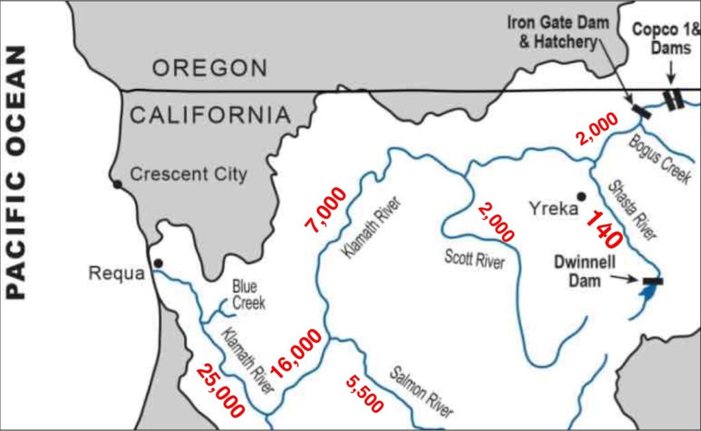
Figure 1. Lower Klamath River with late May of wet year 2017 streamflows in red. Note Shasta River streamflow was only 140 cfs near Yreka, California. Data source: CDEC.
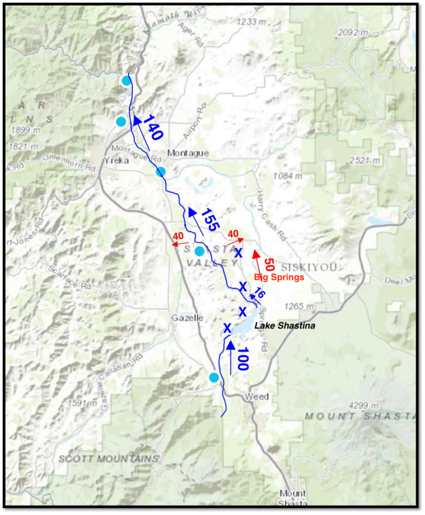
Figure 2. Selected Shasta River hydrology in late May of wet year 2017. Roughly 150 cfs of the 300 cfs total basin inflow was diverted for agriculture, with remainder reaching the Klamath River. Red numbers are larger diversions. The “X’s” denote major springs. Big Springs alone provides near 100 cfs. Of the 100 cfs entering Lake Shastina (Dwinnell Reservoir) from Parks Creek and the upper Shasta River and its tributaries, only 16 cfs was released to the lower river below the dam. Red numbers and arrows indicate larger agricultural diversions. Up to 15 cfs is normally diverted to the upper Shasta River from the north fork of the Sacramento River, west of Mount Shasta.
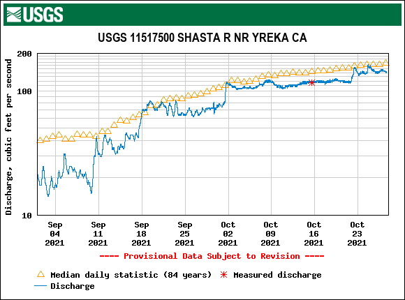
Figure 3. Streamflow during peak Chinook salmon spawning season in the lower Shasta River near Yreka CA in September and October of drought year 2021. Yellow markers show average for the day over 84 years of gage record.
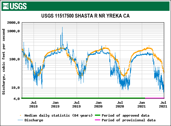
Figure 4. Streamflow in the lower Shasta River near Yreka CA from April 2018 through June 2021. Yellow markers show average for the day over 84 years of gage record. Note the low streamflow in dry summer 2020 and spring-summer of drought year 2021.
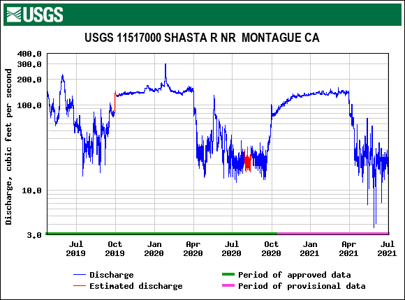
Figure 5. Streamflow in the lower Shasta River near Montague CA from April 2019 through June 2021. Note the low streamflow (<30 cfs) in spring-summer of dry year 2020 and spring of drought year 2021.
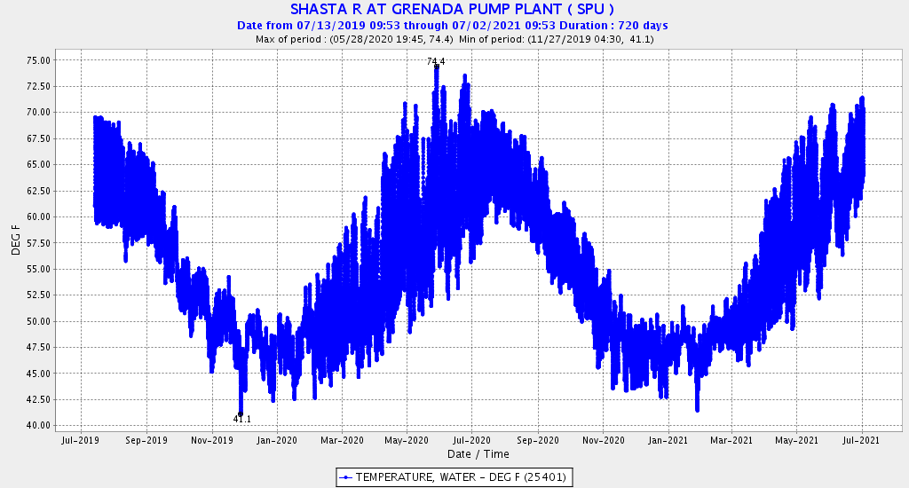
Figure 6. Water temperature (hourly) in the lower Shasta River below Big Springs near Grenada CA July 2019 to June 2021. Source: CDEC.
Bibliography
Jeffres, C. A., R.A. Dahlgren, M.L. Deas, J.D. Kiernan, A.M. King, R.A. Lusardi, J.M. Mount, P.B. Moyle, A.L. Nichols, S.E. Null, S.K. Tanaka, A.D. Willis. 2009. Baseline Assessment of Physical and Biological Conditions Within Waterways on Big Springs Ranch, Siskiyou County, California. Report prepared for: California State Water Resources Control Board. https://watershed.ucdavis.edu/sites/g/files/dgvnsk8531/files/products/2021-11/Jeffres-et-al-SWRCB-2009.pdf
Shasta River Watershed Stewardship Report. 2018. Shasta Valley Resource Conservation District 215 Executive Court, Suite A, Yreka, CA 96097. Version 1.2 April 2018. https://ifrmp.org/wp-content/uploads/2021/10/SVRCD_2018_0548_Shasta_Watershed_Stewardship_Report.pdf#:~:text=Shasta%20River%20Watershed%20strongly%20influences%20groundwater%20chemistry%2C%20which%20is&text=Big%20Springs%2C%20Shasta%20River%20at%20the%20Montague%E2%80%90Grenada%20Bridge%2C%20and%20Shasta%20River