Can Winter Run Chinook Salmon be Saved in 2015?

Various resource agencies are scrambling to protect Winter Run Chinook Salmon this year after last year’s debacle, in which water “saved” in Shasta Reservoir wasn’t cold enough to keep Winter Run eggs and fry alive1. Higher, colder flows are necessary to keep the eggs and fry alive in their spawning and early rearing areas near Redding, but were unavailable last summer because Shasta’s cold-water pool was depleted by the end of August.

The five charts included below tell the story of what happened last year. In summary, these are the main reasons why the Bureau of Reclamation ran out of cold water in Shasta Reservoir…

  • First, approximately 200,000 acre-feet (AF) of cold-water pool storage was released to senior water rights contractors in May. (Amount calculated from Figure 1 and Table 1).
  • Second, approximately 500,000 AF of cold-water pool storage was released in June and July that could be argued was needed for maintaining river temperature control below Redding. However, I would argue that given the precarious state of the Shasta cold-water pool in June and July, federal and state agencies should have released less (to maintain 58°F at Clear Creek instead of the chosen target temperature of 56°F) to sustain Shasta’s cold-water pool. My guess is they could have saved 2000 cfs or about 240,000 AF of total storage in June and July. This water would have come out of the Sacramento River Settlement Contractors’ 560 TAF deliveries for June-July (Table 1).
  • Third, somewhat less cold-water pool water could have been saved in early weeks of August.

If the Bureau of Reclamation had saved this 440,000 AF from May-July (about a third of deliveries), there would have been no extreme mortalities of Winter Run Chinook Salmon in the late August-October period from low flows and high water temperatures. Contractors could have made up some of their loss in the late August-October period when higher colder flows would have been released from Shasta for fish. If Sacramento River contractors were unable to use this water late in season, the water could have been used to maintain Delta water quality standards or left as carryover storage in Shasta Reservoir.

In summary, cold-water pool releases from Shasta Reservoir from May through August of 2014 were too great to support the cold water resource, resulting in the loss of much of the year’s production of Winter Run eggs and fry to low flow, warm water conditions. In similar conditions in 2015, releases for contractor irrigation deliveries should be reduced in order to sustain Shasta’s cold-water pool through the summer. Such protections should be the cornerstone of the Drought Operations Plan being developed by the agencies. NMFS and DFW should not approve the Plan without this element to protect Winter Run.
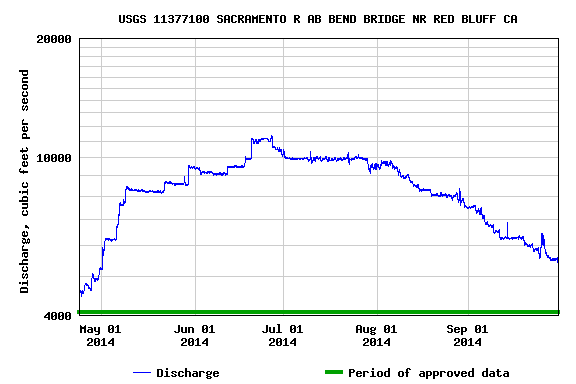
Figure 1

Figure 1. Mainstem flow of the Sacramento River below Redding, May-Sept 2014. Flows generally reflect releases from Shasta Reservoir. (Source: USGS Mobile Data Site)
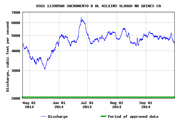
Figure 2

Figure 2. Mainstem Sacramento River flows at Wilkins Slough gage below most of the contractor diversions. (Source: USGS Mobile Data Site)
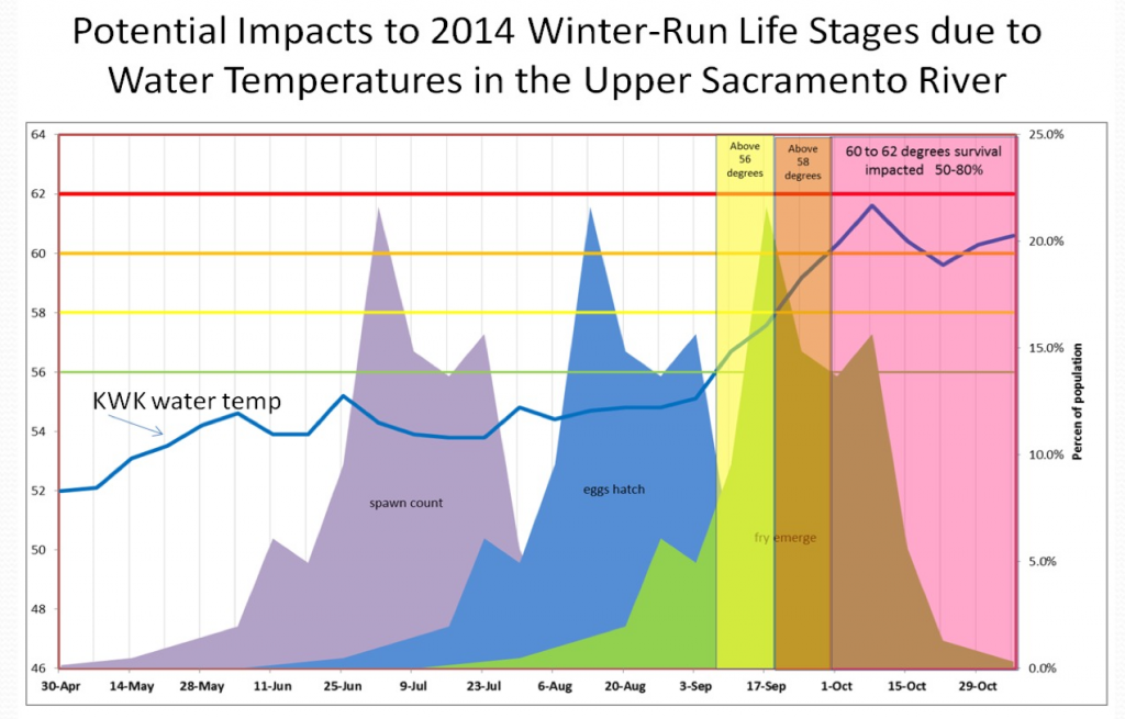
Figure 3

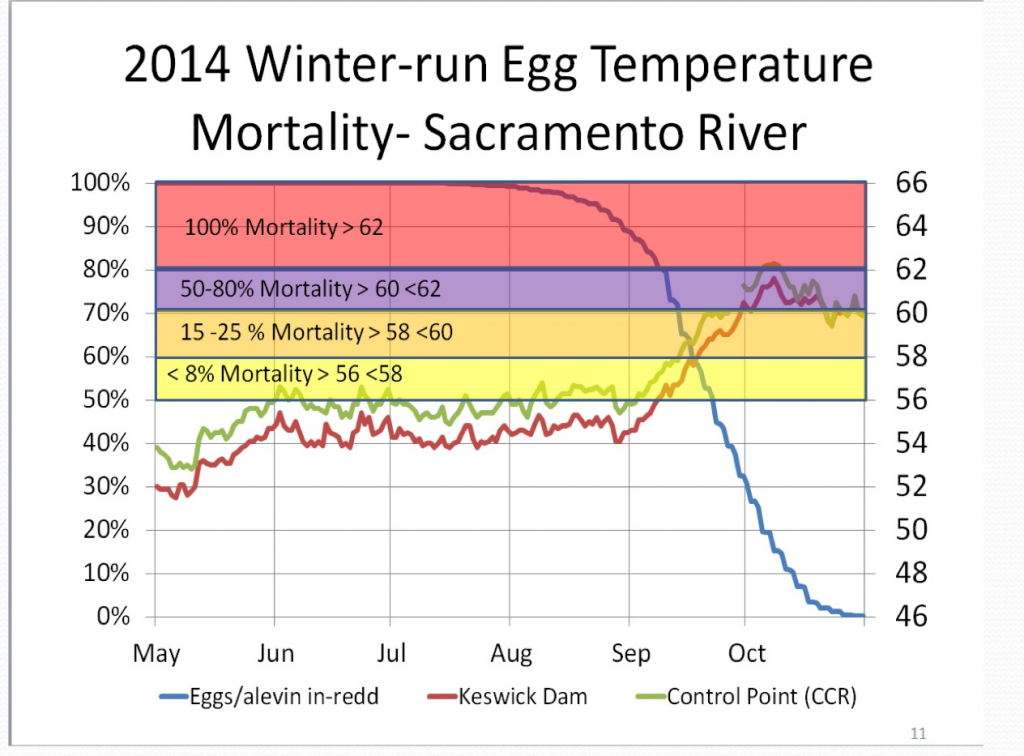
Figure 3. Power-Point slide of risk to Winter Run adults, eggs, and fry as a function of water temperature in Shasta Reservoir releases (as measured Keswick Reservoir releases – KWK).2
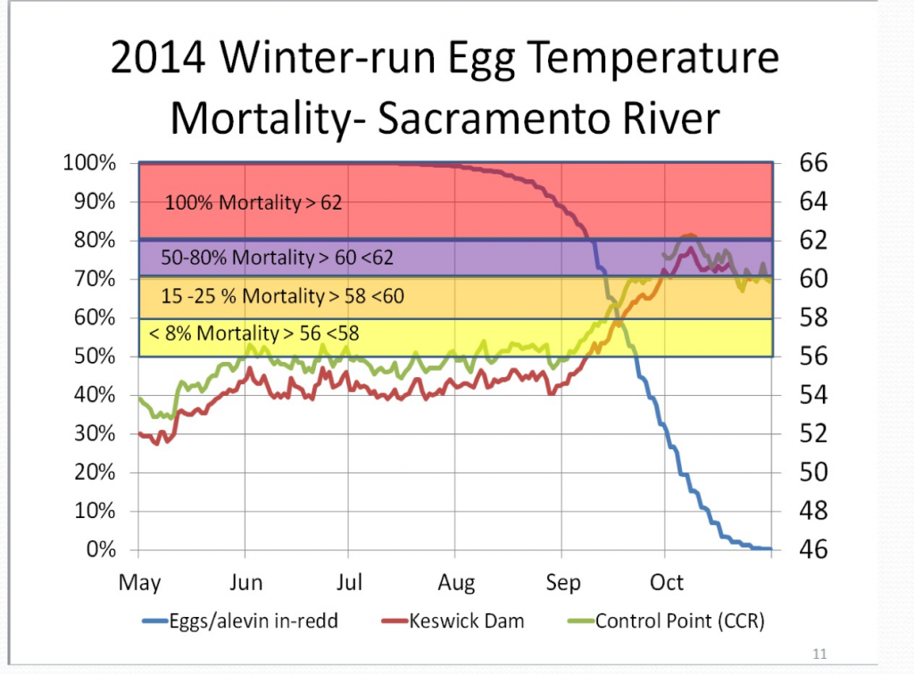
Figure 3

Figure 4. Power-Point slide of risk to Winter Run eggs as a function of water temperature in Shasta Reservoir releases (as measured Keswick Reservoir releases – KWK) and temperature in the river below the mouth of Clear Creek near Redding.3

Table 1

Table 1. Water deliveries from Reclamation to Sacramento River contractors in 2014.
(Source: http://www.usbr.gov/mp/cvo/vungvari/table_28_2014.pdf)

  1. See, for instance, https://cdfgnews.wordpress.com/2015/01/26/agencies-taking-measures-to-protect-winter-run-chinook-preparing-to-release-approximately-600000-fish/
  2. Source: NOAA’s National Marine Fisheries Service’s (NMFS) Update to the State Water Resources Control Board by Garwin Yip, February 18, 2015
  3. Source: NOAA’s National Marine Fisheries Service’s (NMFS) Update to the State Water Resources Control Board by Garwin Yip, February 18, 2015

The Delta Plan – where is the water habitat?

The Delta Stewardship Council’s Jessica Davenport, Program Manager, Ecosystem Restoration and Land Use, released an issue paper in August of last year entitled “Restoring Habitat with Science and Society in Mind”. 1

“The Delta Plan shall include measures that promote all of the following characteristics of a healthy Delta ecosystem:

  1. Viable populations of native resident and migratory species.
  2. Functional corridors for migratory species.
  3. Diverse and biologically appropriate habitats and ecosystem processes.
  4. Reduced threats and stresses on the Delta ecosystem.
  5. Conditions conducive to meeting or exceeding the goals in existing species recovery plans and state and federal goals with respect to doubling salmon populations.”

The Delta Plan,2 much like the Governor’s Bay Delta Conservation Plan (BDCP),3 has no measures that would promote a healthy Bay-Delta ecosystem. The plans virtually ignore water habitat: the characteristics of the water in the hundreds of miles and tens of thousands of acres of open water in the Bay-Delta. The plans fail to even define the components of a healthy ecosystem or how they relate to water habitat:

  • “viable populations” – what constitutes viable?
  • “functional corridors” – what is functional?
  • “appropriate habitats and ecosystem processes” – what is appropriate?
  • “threats and stresses” – what threats and stresses?
  • “conditions conducive to doubling salmon populations” – what conditions?

The plans simply focus on “restoration” of thousands of acres of edge habitat on marginal lands in Suisun Marsh and the Delta, virtually ignoring the “real problem” and its fixes. The “restoration” that is promoted will take decades to implement and will do little to promote a healthy ecosystem, at least in the short term.

The “real problem” is water management in the Central Valley and Bay-Delta. The “real problem” is our insatiable demand for water while virtually ignoring the beneficial uses and public trust requirements of the Central Valley and Bay-Delta ecosystems. There are water quality standards and endangered species biological opinions that provide minimal protections for resident and migratory native fish species. Yet the first thing that regulators do in droughts is relax these protections to provide more water for agriculture. As a consequence, the fish populations and their habitats suffer irreversibly in drier years, and especially in extended periods of drought. The result is fish populations on the verge of extinction, poor Bay-Delta water quality, salt in Delta water diversions, salmon smolts having to be trucked hundreds of miles from hatcheries to the Bay, and no freshwater inflow to the San Francisco Bay estuary.

Water is the ecosystem process ignored in the BDCP and Delta Plan. The characteristics of the water habitat in time and space are the missing element in the plans. The fish habitat that is most important is the water in Delta channels and bays, not the acreage of tidal marsh. Adding tidal marsh habitat will not fix the water habitat or provide a healthy ecosystem

The BDCP justified taking more water via the “tunnels” by offering thousands of habitat acres in return. The Delta Plan promotes these same land acreage solutions.

How can we really restore the Delta as habitat for smelt, salmon, steelhead, sturgeon, and other native fishes? We have to focus on Delta inflows, outflows, tides, and exports: hydrology, salinity, water temperature, and primary productivity patterns in the water habitat. The real habitat of the Delta is the three-dimensional characteristics of water in time and space. What should the water habitat be for Delta smelt when they hatch in the spring to insure good survival? How do we sustain the smelt in summer? Can they actually survive if all the Delta inflow is exported in August under relaxed standards? What happens to all the wild salmon smolts coming out of Central Valley rivers? What kind of water habitat do they need to pass through the Delta? They do not get a truck ride to and around the Delta. What is a “functional migration corridor” for them?

So instead of focusing on acreage, we should focus on the real habitat, water and all of its characteristics in time and space in the Delta, rivers, and the Bay. That way, we can promote the real ecosystem process that provides for a healthy Bay-Delta ecosystem.

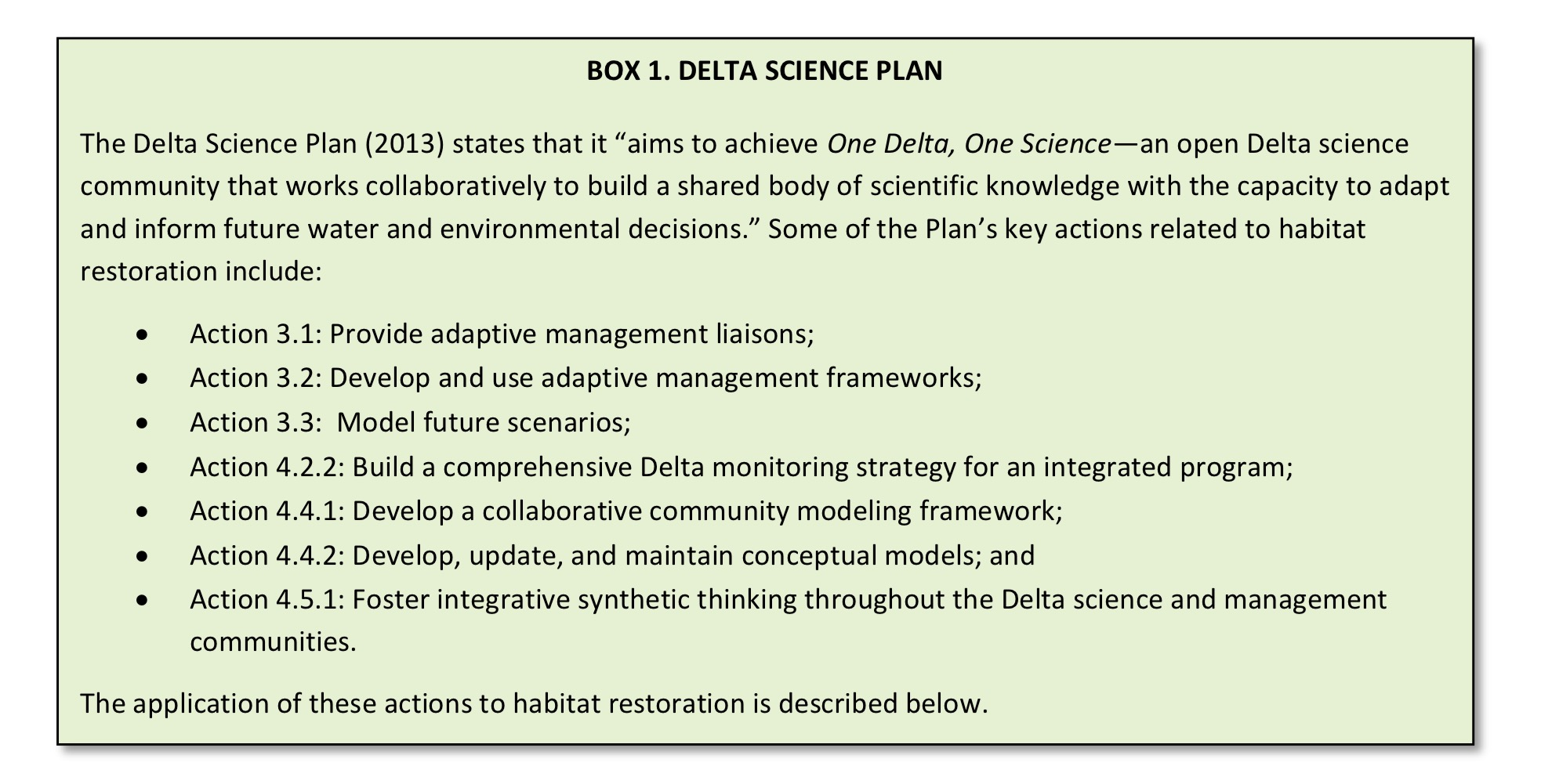
The Delta Science Plan4 is just more talk and smoke and mirrors. What the Delta needs is more water and better water habitat. We do not need a new vision.

http://calsport.org/fisheriesblog/wp-content/uploads/2015/04/Box-1.-Delta-Science-Plan.png

What is wrong with summer water transfers?

Summer water transfers are predominantly made with water released from Shasta and Oroville reservoirs.  Instead of being used by Sacramento Valley CVP and SWP contractors, water is sold to South of Delta contractors who take the water via the South Delta CVP and SWP export pumps.  Non-project water transfers are also facilitated by CDWR.  Transfers usually occur in drought years when allocations to South of Delta contractors are low and excess export capacity exists at the South Delta pumping plants.  Purchasers must also pay for an additional 15-25% of “carriage” water to limit salinity intrusion into the Delta that would occur with export of transfer water.

Under existing “rules”, up to 600,000 AF of water may be transferred through the Delta during the allowed summer transfer “window”.  In 2014, 110,000 AF of CVP water from Shasta Reservoir was transferred from July through November (Reclamation was granted a temporary change to transfer water in the Oct-Nov period in 2014).  In 2014, approximately 300,000 AF of transfers were conducted by CDWR during the summer.  In 2015 CVP transfers of Shasta water are expected to be 240,000 AF, while SWP transfers are expected to be less than they were in 2014.

So what are the problems with water transfers from an ecological perspective1?

  1.  Transfer water is released from reservoirs in summer where during drought years there may be a limited cold-water pool to sustain downstream fish populations through the summer and fall. In 2014, the brood year for Winter Run Chinook Salmon was lost when the Shasta cold-water pool was exhausted at the end of August (Figure 1).  Some would argue that the water would have been released in any case to downstream ag contractors.  However, there are other options that would keep the water in the reservoir (e.g., fallowing programs, water purchase, deferring transfers).
  2. The water is released from multi-year storage, thus limiting the amount of carry-over storage in the coming years that is needed to sustain fish and their habitat, as well as water supplies for public health and safety.
  3. Transfer water exported from the Delta is not the same water released from the reservoirs. Water exported is a combination of Sacramento River inflow, San Joaquin River inflow, and Delta low-salinity (brackish) water from the North, Central, and West Delta.  Sacramento River inflow includes flows from the Feather, Yuba, and American rivers, as well as many smaller rivers.
  4. The already inadequate protections that apply to “normal” export water don’t apply to transfer water. Transfers increase the flow towards the Delta pumps, pulling fish with them.  But the ratio of inflow to outflow that generally limits exports doesn’t count transfer water; there are no restrictions in moving transfer water through the Delta other than carriage water requirements.  Transfer water can make up 25% or more of Delta inflow.
  5. Transfer water exported thus takes water with fish from many Central Valley habitats. Most prominently is the taking of Delta Smelt from the brackish and freshwater zones of the North, Central, and West Delta. Transfer water essentially must pass through the Delta’s designated critical habitats to get to the South Delta export facilities (Figure 2).
  6. When water quality standards for inflow, outflow, and salinity are relaxed, the process is further aggravated. Adding transfers during drought conditions with barriers, DCC open, low exports, low inflows, and low outflows worsens the effects of transfers by bringing in added warm, fresh, low turbidity water to the Low Salinity Zone from the north, while exporting turbid, brackish, higher turbidity, more biologically productive water from the south (Figure 2).
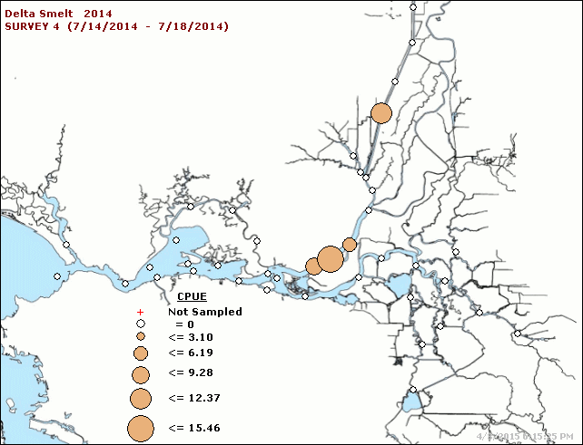
  7. Delta Smelt are highly vulnerable in the summer of drought years because the entire population is within the Delta (figure 3), where water temperatures are near or above lethal levels.
Figure 1.  Water temperature of Keswick Dam releases in summer 2014.  Chart depicts rapid rise in water temperature in early September as Shasta cold-water pool was exhausted. (Chart Source: NMFS)

Figure 1. Water temperature of Keswick Dam releases in summer 2014. Chart depicts rapid rise in water temperature in early September as Shasta cold-water pool was exhausted. (Chart Source: NMFS)

Figure 2.  Freshwater inflows to the Delta (blue arrows) including transfer water must mix first with many other source waters including brackish waters (green lines) from San Francisco Bay.  South Delta exports draw water across the Delta (red arrows).

Figure 2. Freshwater inflows to the Delta (blue arrows) including transfer water must mix first with many other source waters including brackish waters (green lines) from San Francisco Bay. South Delta exports draw water across the Delta (red arrows).

igure 3.  Catch distribution of Delta Smelt in CDFW Summer Townet Survey, July 2014.  (Source: http://www.dfg.ca.gov/delta/data/townet/ )

Figure 3. Catch distribution of Delta Smelt in CDFW Summer Townet Survey, July 2014. (Source: http://www.dfg.ca.gov/delta/data/townet/ )

CDFW proposes to close the Sacramento River above Redding to sport fishing from April 27 to July 31

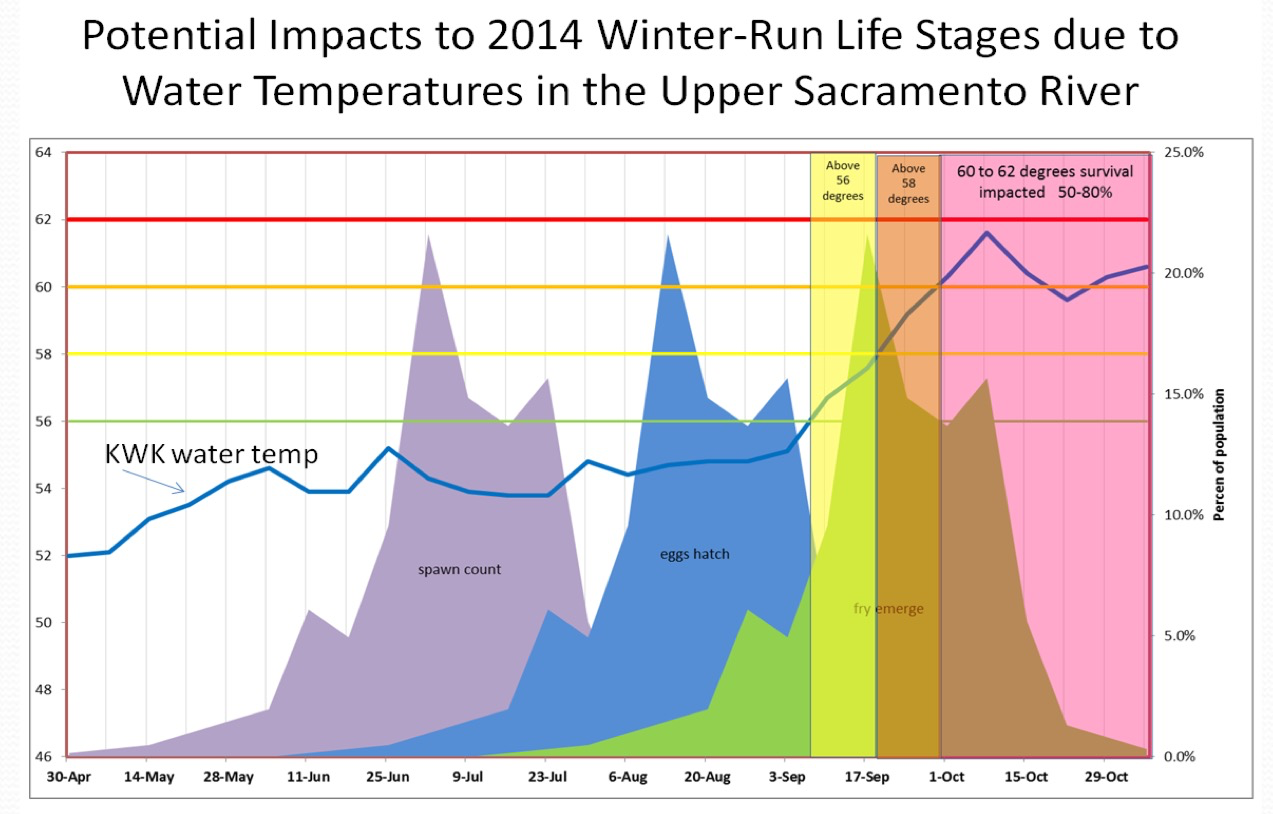
The California Department of Fish and Wildlife proposes to close fishing in the 5.5 miles of the Sacramento River above Hwy 44 Bridge from April 27-July 31 this year.1 These upper few miles of the river below Keswick Dam provide a world-class sport fishery for rainbow trout (salmon fishing in this river reach is permanently closed). The premise of the ban is to reduce mortality on endangered Winter Run Chinook Salmon. The reach is where most of the Winter Run spawn, eggs incubate, and fry emerge in gravels from late spring through early fall (Figure 1). Last summer 95% of the 2014 Winter Run brood year perished from redd dewatering and high water temperatures.

The proposed closure would inappropriately place the drought-management burden on sport anglers when the problem is poor water management in the present drought. The low flows and high water temperatures in 2014 were caused by depletion of Shasta Reservoir’s cold-water pool to meet water demands of Central Valley Project Settlement Contractors in the Sacramento Valley. These senior water rights holders received 1.3 million acre-ft of Shasta storage during 2014. An additional 110,000 acre-ft released was sold to south of Delta contractors via water transfers from July through November. Shasta Reservoir storage peaked last year near 2.4 million acre-ft in early May, then declined to 1.1 million acre-ft in October.

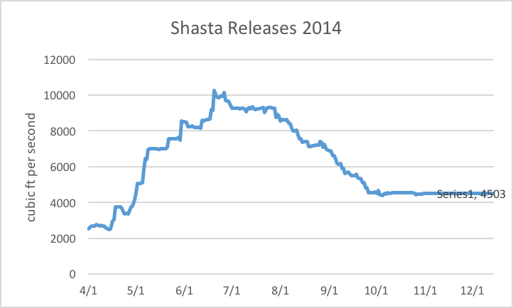
Shasta Reservoir releases were over 6000 cfs from early May through August (Figure 2). Most of the Winter Run spawned in June and July at flows in excess of 8000 cfs. During the August through September incubation period, flows fell to near 4000 cfs, resulting in the dewatering of many salmon redds. Redd dewatering coupled with high water temperatures resulted in the loss of 95% of the brood year production during September, according to CDFW and NMFS.

Closing the fishery this summer implies that sport fishing activities would otherwise contribute to Winter Run mortality when there is no scientific evidence to support this assumption. Boat traffic is mainly drift boats, which minimally disturb fish. The most obvious risk from fishermen would be trampling redds in the low water period in the August-September incubation period, which is not included in the proposed ban. Even that risk is low, since few anglers wade the spawning reaches.

DFW’s blog states: “Given the gravity of the current situation, it is imperative that each and every adult fish be given maximum protection.”2
The “maximum protection” standard would be much better applied if the Department unequivocally supported measures to protect all life stages of Winter Run. Instead of burdening sport fishermen with the proposed ban, the solution is for the State Water Board to reduce deliveries from Lake Shasta to water contractors this summer. If releases had been cut by a third from May-July last year, the Winter Run could have been saved. Yes, this would have come at a substantial cost to state’s agricultural production (Settlement contractors were already cut 25%), but the drought is unprecedented. Winter Run salmon extinction should not be the price paid to keep rice production high this year in the Sacramento Valley.

Figure 1.  Water temperature (degrees F) in Redding reach below Keswick Dam (KWK) in 2014, along with percent of Winter Run life stage present.  Red line shows water temperature where egg/alevin survival is less than 50%.  Source: NMFS

Figure 1. Water temperature (degrees F) in Redding reach below Keswick Dam (KWK) in 2014, along with percent of Winter Run life stage present. Red line shows water temperature where egg/alevin survival is less than 50%. Source: NMFS

Figure 2.  Shasta Reservoir releases from April through October 2014.

Figure 2. Shasta Reservoir releases from April through October 2014.

What is wrong with NDOI?

Delta outflow is the amount of fresh water that exits the Delta for San Francisco Bay. Freshwater outflow is the most important ecological function other than perhaps the tides for the Bay-Delta Estuary. The Net Delta Outflow Index (NDOI) is the parameter that is used as a measure of Delta outflow to manage the ecology, water supply, and water quality of the San Francisco Bay-Delta Estuary. NDOI is a number estimated from a crude set of variables, some measured and some guessed. It is a relic of the past and deserves a quiet burial, the sooner the better. Continuing its use is meaningless, unreasonable, harmful, injurious, and unnecessary.

The NDOI or QOUT is calculated as follows:

QOUT = QTOT + QPREC – QGCD – QEXPORTS – QMISDV1

Where:

  • QOUT Net Delta outflow at Chipps Island
  • QTOT Total Delta inflow
  • QPREC Delta precipitation runoff estimate
  • QGCD Delta-wide gross channel depletion estimate (consumptive use)
  • QEXPORTS Total Delta exports and diversions/transfers
  • QMISDV flooded island and island Storage diversion

All of these parameters are estimates themselves subject to gross errors, which compound to make NDOI useful only as a gross indicator of freshwater outflow to San Francisco Bay.

The main use of NDOI is in Bay-Delta water quality standards and drought emergency change orders:

“ The Delta outflow objectives included in the Bay-Delta Plan and D-1641 for the February through June time frame are identified in footnote 10 of Table 3 and Table 4 of footnote 10. Pursuant to footnote 10, the minimum daily NDOI during February through June is 7,100 cfs calculated as a 3-day running average. This requirement may also be met by achieving either a daily average or 14-day running average EC at the confluence of the Sacramento and San Joaquin Rivers of less than or equal to 2.64 millimhos per centimeter (mmhos/cm) (Collinsville station C2)… The minimum Delta outflow levels specified in Table 3 are modified as follows: the minimum Net Delta outflow Index (NDOI) described in Figure 3 of Decision 1641 during the months of February and March shall be no less than 4,000 cubic-feet per second (cfs) on a monthly average. The 7-day running average shall not be less than 1,000 cfs below the monthly average.”2

Reliance on NDOI is one thing, but using 3-day, 7-day, and monthly average limits borders on insidious. Government agencies have long recognized this and a decade ago commissioned the US Geological Survey to measure Delta outflow with UVM meters that measure water column velocities in real time.
.
The new measurement is defined as Net Delta Outflow or NDO3.

Net Delta Outflow

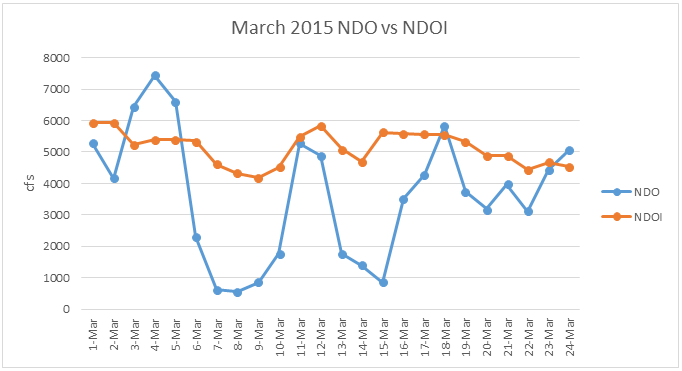
We compared the two parameters for the month of March, 2015. The differences in the parameters as seen in the chart below are significant and appear to be related to the fact that NDOI does not incorporate tidal effects. NDO indicates that outflow is much reduced by high “spring” tides that effectively block freshwater outflow to the Bay. The effect is real and roughly amounts to over 100,000 AF of freshwater flow that did not make it to the Bay in March, which resulted in greater saltwater intrusion and degradation of the Bay-Delta Estuary, as well as degradation of Low Salinity Zone habitat quality and quantity.

March 2015 NDO vs NDOI

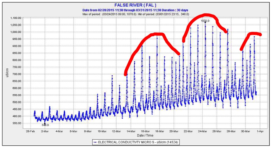
The effect also leads to saltwater intrusion into the central Delta via False River. Delta exports pull some of their water from the west Delta to the south Delta pumping plants via False River. The chart below shows higher salinity water entering False River during high tides with peaks in salinity during spring tides and low NDOs. The salt from these intrusions degrades Delta water quality and the quality of water exported from the Delta to Southern California. The salt is also a signature of the Low Salinity Zone, which is the primary nursery area for Delta Smelt, Longfin Smelt, and many other Delta fish. Pulling LSZ water into the central Delta kills many Longfin and Delta smelt.

False River

It is no longer reasonable to manage Delta outflow and exports with rules that include the NDOI. A vast array of flow, salinity, temperature, turbidity, chlorophyll, dissolved oxygen, and radio-tagged fish detection meters allow instantaneous management of the Delta. Changes are hung up on antiquated Delta standards that are frequently relaxed by the State Water Resources Control Board to satisfy the insatiable water demands of the state and federal water projects and their contractors. The NDOI needs a quick burial. If the Board can issue temporary drought emergency change orders involving the NDOI, why can’t it rely on better measurement to better protect, if only temporarily, the beneficial uses of the state’s water supply?

  1. Source:  http://www.water.ca.gov/dayflow/ndoVsNdoi/
  2.  Source: SWRCB March 5 Temporary Urgency Change Order for Central Valley Project and State Water Project
  3.  http://www.water.ca.gov/dayflow/ndoVsNdoi/