Fundamental Needs of Central Valley Fishes – Part 1c: Spring River Flows

In the coming months and years, regulatory processes involving water rights, water quality, and endangered species will determine the future of Central Valley fishes.

To protect and enhance these fish populations, these processes will need to address four fundamental needs:

  1. River Flows
  2. River Water Temperatures
  3. Delta Outflow, Salinity, and Water Temperature
  4. Valley Flood Bypasses

In this post, I summarize a portion of the issues relating to River Flows:  spring flows.  Previous posts covered fall and winter flows.

River Flows – Spring

River flows in spring drive many natural ecological processes in the Central Valley related to Sierra snowmelt.  Winter-run and spring-run salmon, steelhead, Pacific lamprey, and white and green sturgeon ascend the rivers from the ocean during the spring snowmelt season.  Spring-run salmon arre able to migrate upstream in the high water to hold until late summer spawning.  Winter-run salmon and sturgeon spawn in the Sacramento River below Shasta that same spring.  Pacific lamprey spawn in streams throughout the Valley in spring.  Juveniles, and remnant yearlings of all these species spawned in the previous year, head to the ocean in the high flows.  In the Valley, the spring snowmelt and rains swell the rivers for the annual runs of Delta smelt, splittail, American shad, Sacramento suckers, and striped bass.   In the Bay-Delta, spring flows spur annual productivity that sustains juvenile longfin smelt, Delta smelt, fall-run salmon, green and white sturgeon, striped bass, American shad, and splittail, as well as many resident and estuarine fishes and their food supply.

Much of the Valley’s snowmelt is captured in mountain and Valley rim reservoirs, breaking the link between the ocean and mountains.  In the lower Sacramento River below Shasta Reservoir, spring snowmelt flows are markedly reduced by retention of snowmelt in the reservoir (Figure 1).  The Feather River, the main Sacramento River tributary, are similarly affected (Figure 2).  In the San Joaquin River watershed, absence of flows sourced in spring snowmelt is also severe (Figure 3).  The capture of snowmelt not only reduces flow in Valley rivers and the Bay-Delta, but also reduces sediment load, river scour, water depths and velocities.  It raises water temperatures and limits the extent of natural floodplain inundation.  All of these are important ecological processes on which native fishes depend.
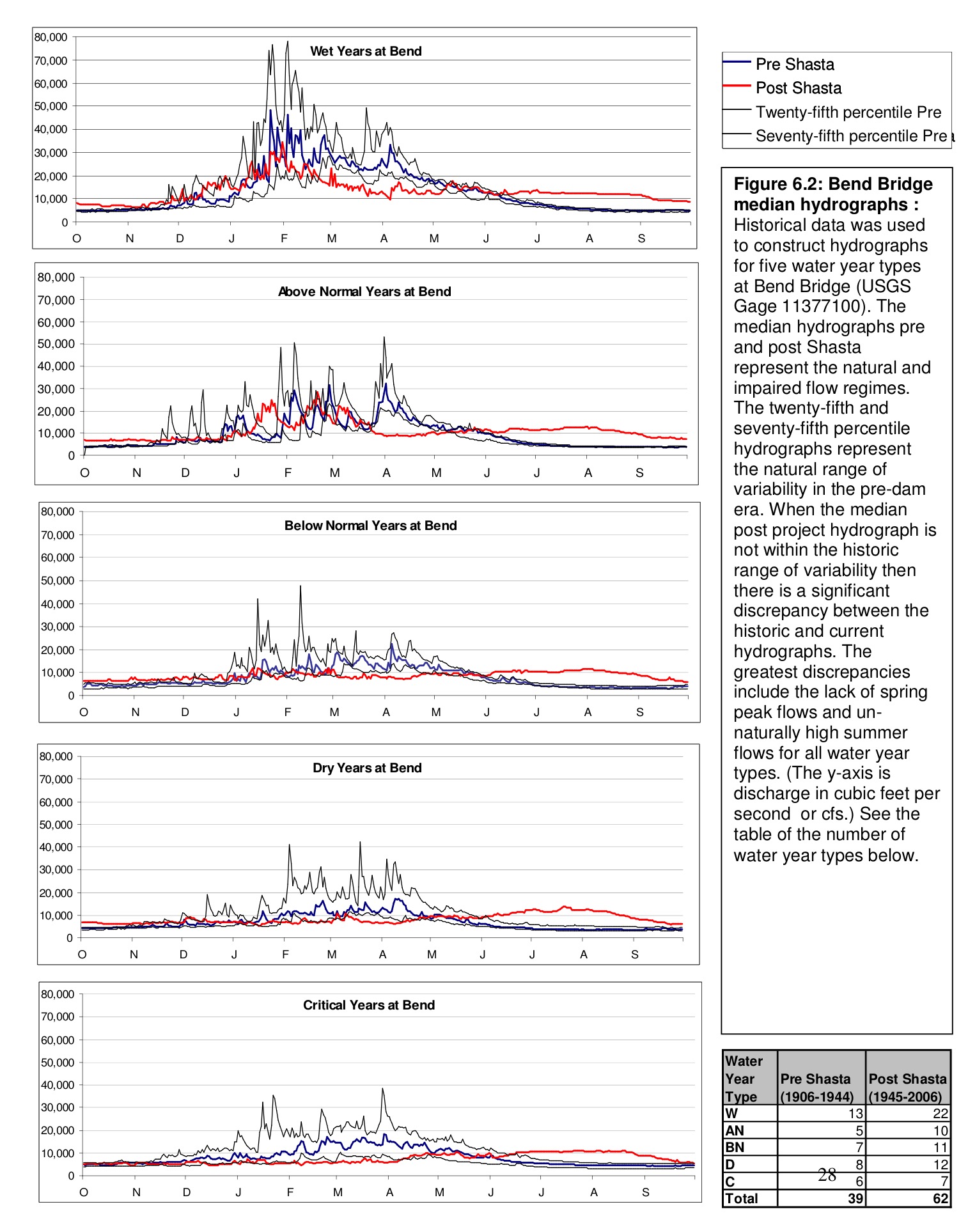
Figure 1. Pre-and post-Shasta flows in the lower Sacramento River near Red Bluff (Bend Bridge gage). Note that nearly all the peak spring snowmelt flows have been removed below Shasta in all year types. (USGS gage data)
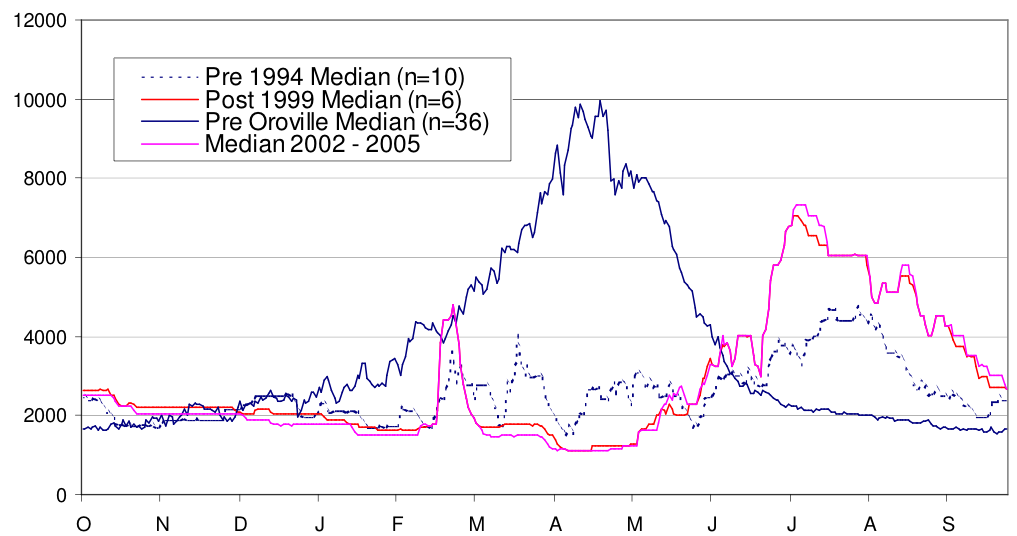
Figure 1. Pre-and post-Shasta flows in the lower Sacramento River near Red Bluff (Bend Bridge gage). Note that nearly all the peak spring snowmelt flows have been removed below Shasta in all year types. (USGS gage data)

Figure 2. Pre- and post-Oroville Reservoir flows in the lower Feather River. (CDWR data)
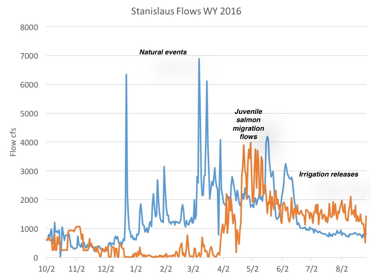
Figure 2. Pre- and post-Oroville Reservoir flows in the lower Feather River. (CDWR data)

Figure 3. Spring snowmelt (natural flow – blue line) is retained in New Melones Reservoir except for prescribed irrigation releases and salmon migration flows (orange line – reservoir releases to lower Stanislaus River). (CDEC data)

Figure 3. Spring snowmelt (natural flow – blue line) is retained in New Melones Reservoir except for prescribed irrigation releases and salmon migration flows (orange line – reservoir releases to lower Stanislaus River). (CDEC data)

Under current operations, spring snowmelt into the Valley reservoirs is generally held in storage except for minimum downstream flow requirements, agricultural demands, Delta inflow and outflow to meet water quality standards, and minimum flow specifications for endangered fish in biological opinions.  Flow releases for agriculture and fish are generally re-diverted soon after release, thus resulting in further reduction of downstream flows (this is the case for  the lower Sacramento River in Figure 1, the lower Feather River in Figure 2, and lower Stanislaus River in Figure 3).  Critical conditions often appear below these diversions in the lower Sacramento River (Figure 4), in the lower San Joaquin River, and in outflow from the Delta to the Bay.

What is needed are spring releases (spills) from the major Valley reservoirs to the major rivers below dams that carry at least in part to the Bay, to stimulate and sustain migrations of the adult and juvenile anadromous fish throughout the Valley.  Water releases timed to the natural flow pulses would stimulate migration, providing even more flow and stimulus for young anadromous fish from all the Valley rivers to pass successfully through the Delta and Bay to the ocean.
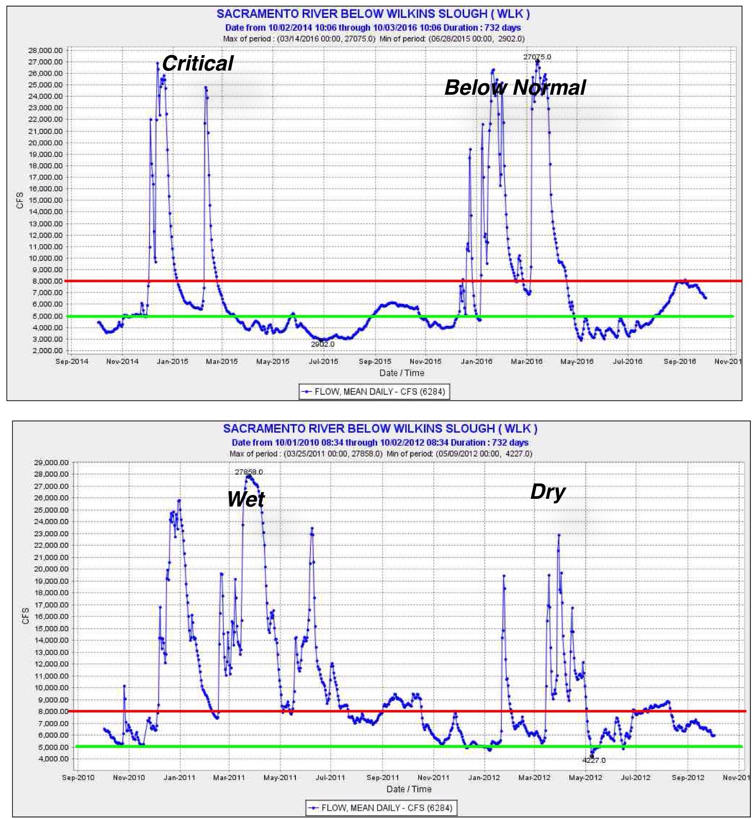
Figure 4. River flow (cfs) in lower Sacramento River below major irrigation diversions in four recent years representing four water-year types. Green line represents minimum flow needed to maintain a semblance of essential ecological processes in the lower river. Red line represents preferred minimum level protecting ecological processes. May-June flow is generally depressed except in wet years.
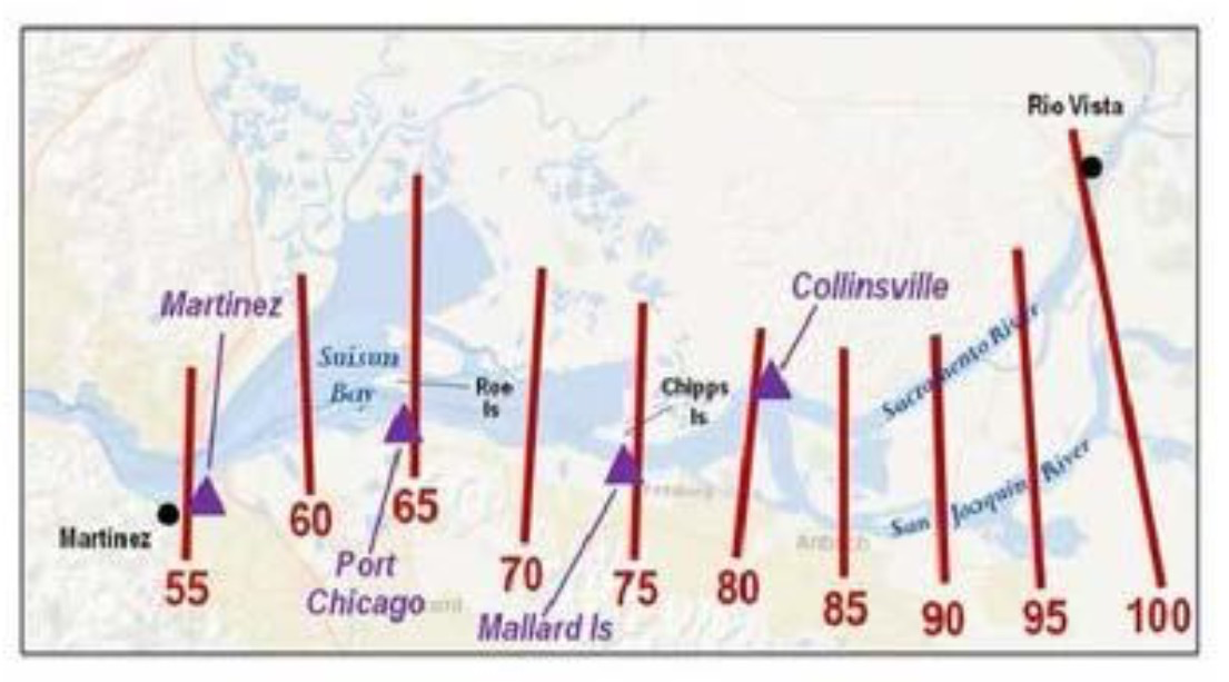
Figure 4. River flow (cfs) in lower Sacramento River below major irrigation diversions in four recent years representing four water-year types. Green line represents minimum flow needed to maintain a semblance of essential ecological processes in the lower river. Red line represents preferred minimum level protecting ecological processes. May-June flow is generally depressed except in wet years.
Department of Interior’s Central Valley Anadromous Fish Habitat Restoration Program

CVPIA 2017 Annual Work Plan Draft Cover Art

Over the past twenty-plus years, the US Bureau of Reclamation and the US Fish and Wildlife Service have implemented multiple actions to restore physical habitat for salmon and steelhead in the Central Valley.  While these agencies in the Department of Interior have focused much of their efforts on the tailwaters of Reclamation’s federal Central Valley Project dams (Shasta/Keswick, Whiskeytown, Folsom/Nimbus, and New Melones), they have implemented projects on other tributaries as well (e.g., Butte Creek).

The overall mandate and effort stems from the Central Valley Project Improvement Act (CVPIA) of 1992 and its sub-element – the Anadromous Fish Restoration Program (AFRP).  The Act established the Central Valley Project Restoration Fund (CVPRF or Restoration Fund), which includes the Trinity River Restoration Plan and the San Joaquin River Restoration Plan.  Funding comes from appropriations from the U.S. Congress, collections from water and power contractors, and non-federal cost-share obligations.  Funding varies annually – the federal share for 2017 projects is budgeted at $22 million.1  Total funding for Interior’s 2017 efforts in the proposed federal budget is approximately $55 million.  Major projects for 2017 include stream channel restorations and fish passage projects throughout the Central Valley.

With the changes that will come with the new federal government administration in 2017, we can expect many changes to the program, including funding.  Setting priorities and funding allocation for the coming year will be a complex process.  The state and federal goals and objectives may be in conflict.  The 2017 and coming years’ programs will help determine the future of Central Valley salmon, steelhead, sturgeon, American shad, and striped bass.

Commercial and sport fishermen will have to be especially vigilant.  The whole restoration process has so many components that often are uncoordinated.  Resource advocates should seek a stronger role in the process and come together in common purpose.  Let’s start by having a strong voice in the future of CVPRF and CVPIA-AFRP.

Smelt Working Group recommends cutting Delta exports when large group of Delta smelt shows in survey nets

Last week I opined about the lack of agencies’ (Smelt Working Group) concern relating to high Delta exports so far this December.  SWG:  “However, members are concerned regarding today’s OMR flow (daily average of approximately -10,000 cfs) and how it could influence the future distribution of the species. … The SWG expressed concerns regarding the current OMR flow (~-10,000 cfs). … A minority of the membership stated that we do not know what percentage of the population is currently at risk of being entrained; that entrainment into the OMR corridor could be occurring now and we would not know it. This minority indicated OMR should not exceed -5,000 cfs immediately.”  (Smelt Working Group 12/5/16 meeting).

I was incorrect to label it a lack of concern when it was really lack of management action.  The SWG had noted that two smelt had been caught in November trawl surveys in the lower Sacramento River near X2 (~2700EC), which was above km 81 and below km 85 on 12/5 (X2 actually reached km 95 on high tides by 12/10/16).

Kilometers above the Golden Gate Bridge in Bay-Delta estuary.

Kilometers above the Golden Gate Bridge in Bay-Delta estuary.

As it turned out, the minority recommendation was not adopted and high exports (~10,000 cfs) continued.

On 12/12 the SWG met again.  It noted recent higher exports, an upstream movement of X2 to km 90 (because of higher exports), and perhaps most important the capture of 221 Delta smelt near km 90 in a single trawl on 12/10.  Three Delta smelt were also captured in a trawl in Three Mile Slough (km 98).  SWG:  “Members indicated great concern that Delta Smelt could begin migrating upstream in the very near future, and find appropriate cues to move upstream on the San Joaquin River and into the sphere of influence of the pumps where the adults and subsequent young of the year will be at increased risk of being entrained into the Old and Middle River corridors, or even into the facilities themselves.” 

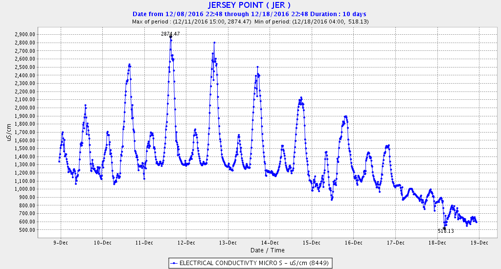
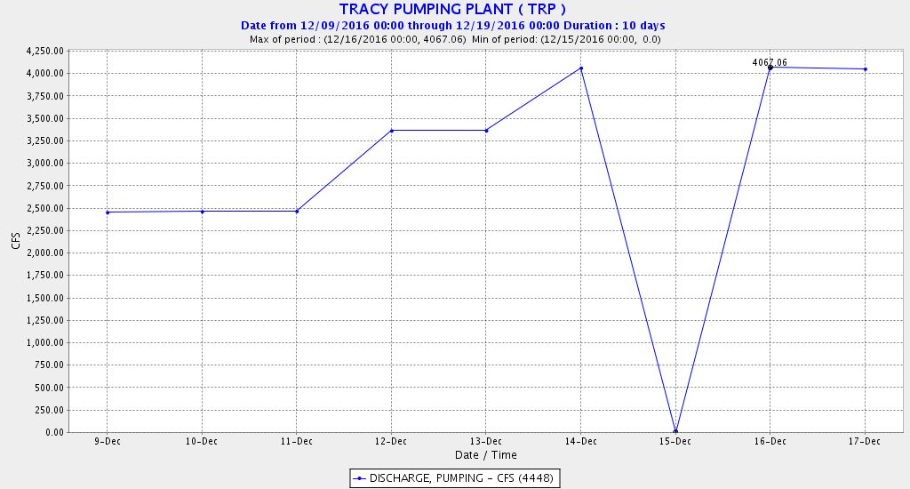
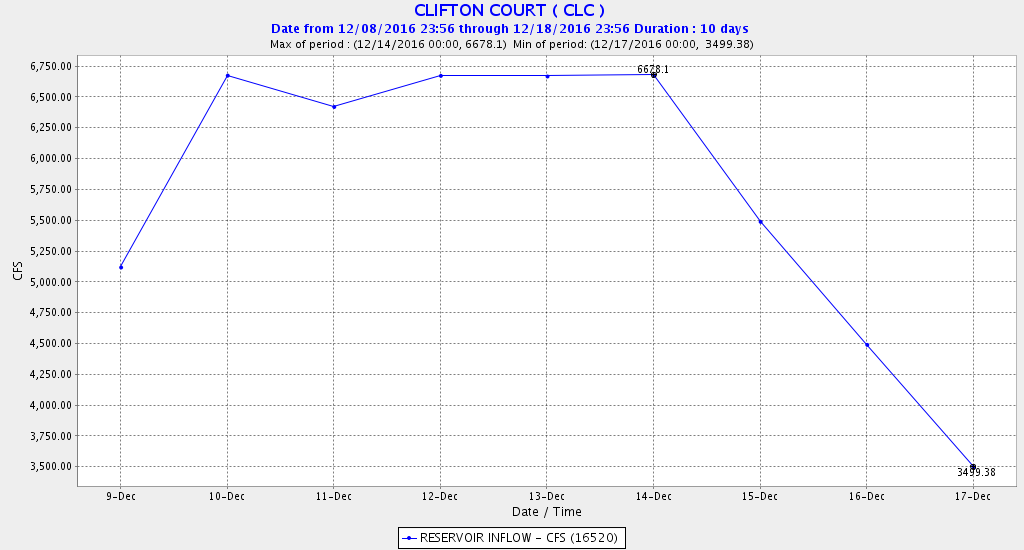
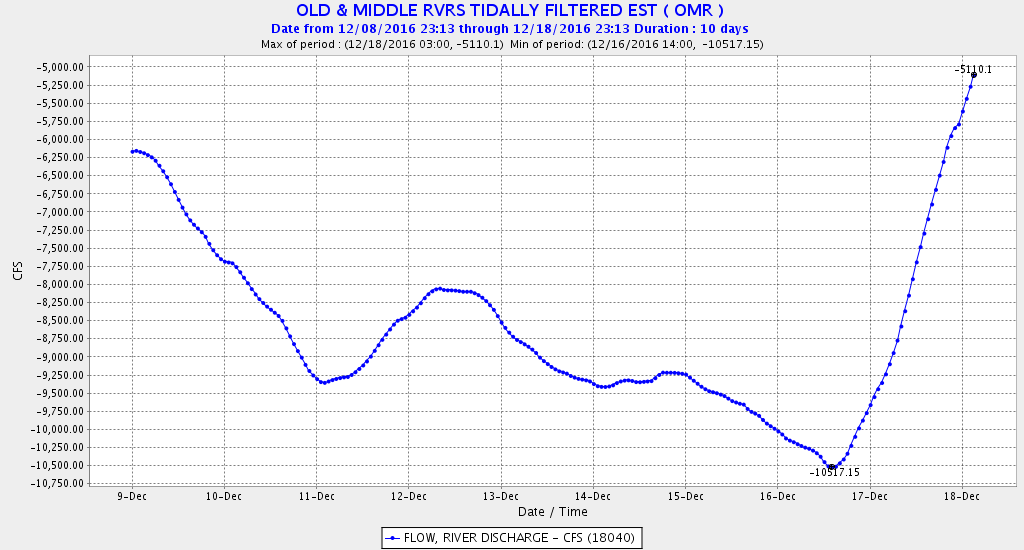
At the 12/12 meeting, the SWG unanimously recommended reducing exports to limit OMR to -5000 cfs, per the Delta Smelt Biological Opinion.  Reclamation/Interior/CDWR management did not adopt this recommendation until 5 days later.  Exports were initially increased, and the OMR fell further to -10,323 cfs (see chart below) before export cutbacks started on 12/15, when the big surge of stormwater hit the Delta.  As a consequence of th surge, X2 on the lower San Joaquin River pushed downstream of km 90 after 12/17.  It is possible that some of the contingent of Delta smelt that were concentrated near X2 before 12/17 were drawn into the central Delta before OMR was limited.  It remains to be seen if the -5000 OMR limit will be adequate to protect what appears to be a potentially significant uptick in the Delta smelt spawning population compared to the past four years.  I wonder if these smelt were a consequence of last July’s outflow pulse.  Are Delta smelt potentially making a small comeback like water year 2010, when OMR December limits in the 2009 Delta smelt biological opinion were first put in place?

Combined flow in Old and Middle River in the central Delta. Minus flows represent the effects of Delta exports from the south Delta. Exports were cut from 11,000 cfs to 7500 cfs on 12/16-17.

Combined flow in Old and Middle River in the central Delta. Minus flows represent the effects of Delta exports from the south Delta. Exports were cut from 11,000 cfs to 7500 cfs on 12/16-17.

Salinity (EC) at Jersey Point in lower San Joaquin River (km 98) 12/9-12/17. Sharp drop after 12/14 due to reduced exports and higher Delta inflows.

Salinity (EC) at Jersey Point in lower San Joaquin River (km 98) 12/9-12/17. Sharp drop after 12/14 due to reduced exports and higher Delta inflows.

Federal Tracy Pumping Plant daily average exports from the south Delta 12/9-12/17. The Water Bill was signed by the President on 12/16, allowing increased federal Delta exports. (4400 max)

Federal Tracy Pumping Plant daily average exports from the south Delta 12/9-12/17. The Water Bill was signed by the President on 12/16, allowing increased federal Delta exports. (4400 max)

State Clifton Court daily average exports from the south Delta 12/9-12/17. (6800 max)

State Clifton Court daily average exports from the south Delta 12/9-12/17. (6800 max)

Water Year 2016

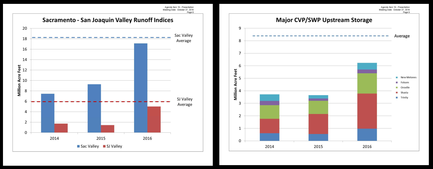
At an October 27, 2016 meeting of the Delta Stewardship Council, John Leahigh, Department of Water Resources chief operator for the State Water Project, briefed the council on Water Year 2016. Precipitation-runoff and reservoir storage were up considerable compared to 2014 and 2015.  However exports were lower than expected, with reduced deliveries – only 5 to 75% – to south of Delta water contractors.

water-year-2016Mr. Leahigh attributed lower Delta exports to several factors:

  • A concerted effort to conserve Shasta storage (for winter-run salmon) at the expense of water deliveries, mainly to south-of-Delta contractors.
  • Higher summer Delta outflow that was needed to repel saltwater intrusion into the Delta caused by higher-than-normal tides associated with the warm-water “blob” along the coast. (This outflow served the dual purpose of reducing the salinity of Delta export water and allowing the water projects to meet salinity standards for Delta agriculture – see previous post.)
  • Lower San Joaquin River Delta inflow that “creates a dynamic in the Delta that makes it difficult to move stored water from the Sacramento basin to the south Delta”.
  • An inability to export Valley stormwater in winter-spring: “If we don’t pick it up, it ends up in the Bay and into the ocean.”  (This is a not-too-subtle reference to winter-spring export restrictions for endangered fish and pitch for the proposed Delta tunnels.)

Mr. Leahigh concluded:  “I think the key messages would be flexibility, nimbleness, and the fact that we have processes in place that would help us react to whatever we end up seeing in the coming year; there’s always a new challenge with respect to the hydrologic pattern and the regulatory environment, so just having those processes in place puts us one step forward.”

The important lesson here is that the state and federal water projects are flexible and nimble when it comes to water exports and deliveries.  When it comes to the short-term needs of the fish and their habitat, not so much.  The projects are ready with Temporary Urgent Change Petitions to benefit water deliveries, but not the environment.

Fundamental Needs of Central Valley Fishes – Part 1b: River Flows – Winter Flows

In the coming months and years, regulatory processes involving water rights, water quality, and endangered species will determine the future of Central Valley fishes.

To protect and enhance these fish populations, these processes will need to address four fundamental needs:

  1. River Flows
  2. River Water Temperatures – holding, spawning incubation, juvenile rearing and migration.
  3. Delta Outflow, Salinity, and Water Temperature
  4. Valley Flood Bypasses

In the previous Part 1a post, I discussed river flows during fall.  In this post, I discuss river flows during winter.

Winter Flows

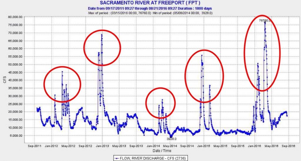
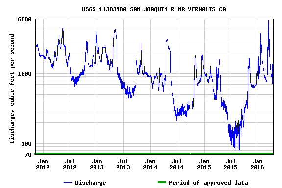
Winter is the season of high river natural flows.  Even in drought years, Sacramento River flows measurably spike during storms that provide stormwater runoff from numerous undammed tributaries and local sources (Figure 1).  On the mainstem Sacramento River and those of its tributaries that also feature rim dams, most of the stormwater inflow is captured and stored for spring-fall water supply.  On the San Joaquin River, all the major tributaries and mainstem have large storage reservoirs that capture Sierra and upper Valley runoff, so there is limited controlled winter runoff (Figure 2).

Winter flows are needed to attract adult winter-run and spring-run salmon, smelt, steelhead, and sturgeon to upriver spawning grounds.  Winter flows also carry young salmon and steelhead to the Delta, Bay, and ocean by providing velocity, water temperature, and turbidity conditions that speed migration and deter predation by birds and fish.  Winter flows stimulate food production and availability.  Winter flows and associated high water levels provide access to off channel and floodplain rearing areas that provide refuge and food.  Winter flows clean substrate and wash gravels, and thus improve spawning conditions.  High winter flows wash sediment, nutrients, and organic material into the estuary that stimulate Bay-Delta productivity.

On the Sacramento River, winter flows carry juvenile winter-run, spring-run, late-fall-run, and fall-run salmon through up to 200 miles of rivers and the Delta to the Bay and ocean.  Much of the route is leveed and channelized, with little cover/refuge and abundant predators.  Higher flows provide turbidity and lower water temperatures that deter predation.

In the San Joaquin River watershed downstream of the rim dams, flows are minimal in the absence of flood flows and dam spills.  Thus, de facto drought conditions persist downstream of San Joaquin watershed dams in all but the wettest years.  Recruitment into the salmon populations is confined to San Joaquin offspring produced in wet years, augmented by hatcher strays, since there is minimal juvenile survival to the ocean in other years because of low flows.

In the non-flood years where reservoirs capture most reservoir inflow during the winter, supplemental releases from Central Valley reservoirs should be considered to piggy-back on and enhance natural flow pulses to benefit salmon and other native fish.  Such action would most benefit salmon populations below rim dams.  Such releases can be prescribed as a portion of the natural or unimpaired inflow to the reservoirs.

Figure 1. Daily average Delta inflow from the Sacramento River 2012-2016 as measured at Freeport. Red circles denote winter-spring flow pulses that support important ecological processes such as salmon migration. Water years 2012-2015 were drought years; 2016 was a below-normal water year.

Figure 1. Daily average Delta inflow from the Sacramento River 2012-2016 as measured at Freeport. Red circles denote winter-spring flow pulses that support important ecological processes such as salmon migration. Water years 2012-2015 were drought years; 2016 was a below-normal water year.

Figure 2. Delta inflow from the San Joaquin River 2012-2016 as measured at Vernalis. Prescribed fall and spring flow releases from reservoirs for salmon migrations dominate the hydrograph in these drought years. Winter flow pulses were lacking with the exception of 2016. Water years 2012-2016 were drought years in the San Joaquin watershed.

Figure 2. Delta inflow from the San Joaquin River 2012-2016 as measured at Vernalis. Prescribed fall and spring flow releases from reservoirs for salmon migrations dominate the hydrograph in these drought years. Winter flow pulses were lacking with the exception of 2016. Water years 2012-2016 were drought years in the San Joaquin watershed.